|
|
Post by Philip on Nov 5, 2009 21:47:32 GMT -8
IMO, that's what the Foothill Gold Line extension should have been, branching off from the El Monte Station. I think LRT should continue to at least Azusa on the Foothill line. Metrolink would be nice, but the service just isn't frequent enough and it's more expensive to ride. It would be cheaper to build though, right? However, I would definitely favor anything past Azusa to be Metrolink and connect with the El Monte Station as you said and the existing Foothill 2B stations (Montclair, etc.). |
|
|
|
Post by kenalpern on Nov 5, 2009 22:20:12 GMT -8
Thanx for the kind words, roadtrainer. Whitman, I entirely agree.
|
|
|
|
Post by metrocenter on Nov 6, 2009 9:35:09 GMT -8
Thanx for the kind words, roadtrainer. Whitman, I entirely agree. Hey Ken, I don't think roadtrainer and Whitman are involved in this discussion. Sincerely, the metrocenter.  |
|
|
|
Post by kenalpern on Nov 6, 2009 12:30:30 GMT -8
Hmmm...did they get deleted? I just saw their posts, and responded.
|
|
|
|
Post by bobdavis on Nov 7, 2009 23:01:38 GMT -8
Regarding Metrolink to the northern San Gabriel Valley: Metrolink (SCRRA and/or LACMTA) owns a track from about a mile east of Baldwin Park (Orange Ave. Junction) to Azusa. It's the former Pacific Electric "Rivas Cutoff", built in 1950 to connect the San Bernardino Line to the Monrovia-Glendora Line, allowing the eastern end to remain for freight service when the portion between El Sereno and Monrovia was abandoned in 1951. It would require extensive rebuilding to support passenger operation to Azusa, and the City of Azusa might have objections to extending the line eastward a few blocks on 9th St. (where PE had street running past their Azusa depot) to be near the Gold Line station. As far as I know, the only service currently using this track is a once-a-week local freight. Among other things, it has a fairly sharp curve running around the edge of an abandoned quarry which would hamper any sort of high-speed operation.
|
|
|
|
Post by wad on Nov 8, 2009 5:06:24 GMT -8
wad: I'd heard that before. Do you know what law that is? This sounds like some that should be targeted in the Transportation Re-authorization Bill. I don't know if it's state or federal, but I remembered when the county was adding hundreds of miles of HOV lanes in the 1990s. Each freeway that had its fast lane converted to an HOV lane had a mixed flow lane added in its place. |
|
|
|
Post by Justin Walker on Nov 18, 2009 0:55:51 GMT -8
By no stretch of the imagination does it sound easy. Agreed. Branching off of the existing Red/Purple Line, no matter how you cut it, would not be easy. You have to wonder why the Red Line planners didn't think of this... But wait! They did! Once upon a time, the dream was to have heavy rail lines reaching to every corner of the county. The Downtown LA-North Hollywood Metro Rail line was to be merely the starter line of a much larger system. In 1982, it was therefore recommended that the Metro Rail line through downtown along Hill Street be built as two-level stations (a la present-day Wilshire/Vermont station) to allow for easy future branch line construction. 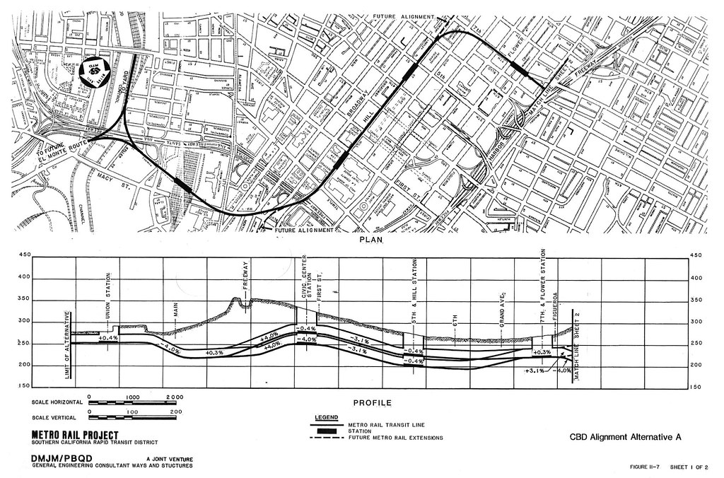 As you can see above, two "future alignments" would have been allowed: - "South Los Angeles extends service south from the Central Business District along Vermont to the vicinity of Pacific Coast Highway and then east to the Long Beach area"
- "Burbank/Glendale extends service...to the Glendale/Burbank area"
(Check a 1980 Prop A map to see what that might have looked like.) 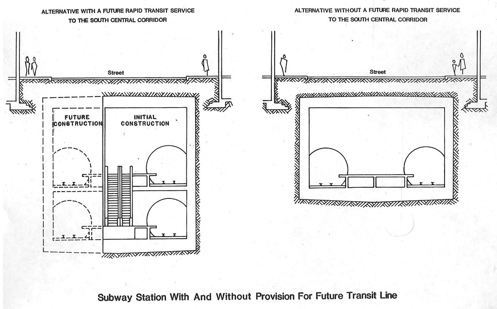 The two-level concept unfortunately disappeared later that year: " In view of the Los Angeles County Transportation Commission's recent decision to continue planning for a light rail transit line in the south central corridor, future provisions for rapid transit may not be necessary." Hello Blue Line, goodbye easy subway extensions (and goodbye easy Whittier Subway)!  |
|
art
Junior Member

Posts: 64
|
Post by art on Nov 24, 2009 21:57:33 GMT -8
The fine Dr. Alpern, what am I , chopped liver? [ftp] 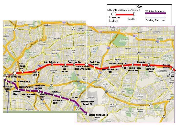 [/ftp] An extension if the redline down the el Monte Busway is also pictured, it was for a senior project. I'll post a better pic later, but this gives a better iidea of my alignment idea. Not even a mention in your article? I know I havent been around for some time, but dang! haha ;D Just messin with you, its nice to see this concept taking flight amongst members of the TC. I have not been around, working and elacamp as well as 3 boys taking up my time, plus the wifey isnt permissive of me taking 3 hours to post my transit ideas. Either way, both the El Monte HOV conversion as well as the whittier purple line extension have been in the halls of the MTA library for decades now. When I began touting them both as the best way to create comprehensive and pragmatic eastside rail coverage about a half decade back (along with the esgl taking the 60 corridor and randolph street row for the se cities), all I really did was make a few tweaks to exisiting ideas to fit into current development and ridership concentrations. I dont want to act like an egomaniac, especially since I made not a penny and swallowed much flack, but it feels REALLY good to see my concepts and ideas coming to fruition, on several things: -I made comments about esgl alignment around Lorena/1st/Indiana/3rd on this board over a half decade back, as well at numerous scoping meetings and letters/calls to the MTA. I even noted the half century pilgramage between el mercadito-la gloria and the tamaleria/party store across 1st -I noted how the esgl shouldve run straight south from UnStation rather than that curve to alameda 5 years ago, including noting how that extra space would give room for portal to connect to the DTconnector -the stations between Ford and Atlantic are too close, dimishing travel time -the major travel route most eastsiders take into DTLA is more south, in the historic core where busses all meet, this will affect ridership much like how the goldline has trouble grabbing all the Fig bus riders from NELA If you go back to p1 where i posted these maps, i also discussed issues of intricate detail with these concepts, and the esgl. It really bothered me to talk to people/mta/consultants and be treated like I was some gadfly marking lines on a map (of course thats how we all start, that and a headache from a 45 minute bus stop experience!) when i very diligently looked at these concepts thoroughly before concluding. It is still bittersweet to see things I dang told people incessantly now creating problems with our built projects, and it is downright appalling to see many of those comments about future endevours still being ignored. My senior thesis in urban planning was on the EM busway HRT conversion and Purple line whittier extension, complete with renderings and a sketchup model, Jerard saw the hard copy years ago and hopefully I can make it to a meeting to show any TC members interested. Here are some of those observations and a few new ones I picked up onthe way: ESGL 1 & 2 - The Atl station should have been on the east side of the boulevard to make more distance between it and CC station. Plus Atlantic bl is designated as a mini highway, I dont even know if an at-grade crossing is legally feasable. The Atl/Pomona intersection is jam packed all day, even if it is legal putting an LRT crossing every 6-12 minutes would be absurd and inconceivable. Atl at this point holds the only 60 freeway offramp, and handles a huge amount of traffic as well is quite dense. I dont know how the train will cross atl in anything but an el configuration, meaning station rebuild as well. -In a perfect world the hairy S curve wouldve been at least a trench. It can stil be done, except an at-grade crossing would probably still stay at Lorena and crossing gates would be needed to maintain speed. East of Lorena the ROW merely stays level while the hill rises going into the tunnel and allowing for a mid block ped crossing between the mercadito and tamaleria, half century safety hazard left unfixef by a negligent city solved as well. The trenched row would curve southeast to run behond the building on the SW corner of Indiana/1st, mitigating any traffic interaction with the train. There is enough room for a protal just east of indiana in the several dozen yards between this conceptual portal and the station. i was scared of the 3rd/indi crossing but was pleasantly suprised by how the MTA pulled it off, all that is needed is auto crossing gates. -The cost estimates for the SR-60 route for phase 2 are absurdly and unecessarilly high. The MTA has proposed putting the train in an el config along an elevated freeway which is redundant. take a cue from the 10 fwy widening thru El Monte for the carpool lane extension and widen the southern edge of the 60 fwy by 25 feet. The slope along the fwy has more than enough room for this widening and it will be MUCH cheaper than a total elevated alignment for the 2 miles between Sadler and Vail. The soundwall wil have to be moved though, but this is a tremendous opprtunity to cut costs and give us elevated rail using prexisting infrastructure. the main cost would be 5 small bridges over crossing roads, other wise the grade sepeartion is already there. The train can also be at-grade if it is placed on that landscaping area between the Montebello Town Center and the 60, taking another .75 miles of elevated and cutting costs. I would also note what an excellent opportunity this station will be to create a dense TOD community on the expansive parking lots as well as serve southside montebello and south sangabe with shuttles as they are so close. Same goes for the supposed el config along whittier narrows from san gabriel bl to SElMonte HS. The MTA is calling for a total elevated alignment in an area with no density and little crossings. If the train made slight curves at freeway offramps, but kept on the southside of the 60 alignments and had crossing gates this 2-3 miles of elevated would be at-grade. El is unecessary here, and a waste of money. Lets put grade seperations where people are. I would guestimate these 2 ideas would shave over 4.5-600 million off the cost easilly, making it much more FTA fund viable. The washington alignment is a bad idea, unless youre from south pico or los nietos. the worst part is that the randolph st PE row is a mile south of washington, why build el in a trucking zone when you have the row grade seperate nearby? This ROW should really be a spur of the blueline from the slauson station thru the SE cities, but thats another discussion. On the HOV redline conversion to El Monte -This is a no-brainer, the major costs would be the portal to rise from just east of union station to the at grade running alignment, bridges at Chavez, CSLA-710, and to get into the EM transit center from baldwin. Otherwise it is laying down track on the far right portion of the HOV lane and building stations. The HOV lane only needs to be pushed onto that extra buffer area now seperating the HOV lanes from normal traffic, which runs for 8-9 miles. Lots of money savings there. The stations would require some investment, building multiple bridges to span the on/offramps and connect to the adjoining neighborhoods and activity centers on both ends of the stations. that would create better access to Garvey/Valley as well as use the extensive HRT station length to reach 2 major streets in one station (for instance Atlantic-Garfield, Del Mar/ San Gabriel bl). The stations should also be completely enclosed with clear doors only opening in sync with train doors when they come in to mitigate freeway noise and wind. they do this in Asia, Europe and Latin America and I think it would work for this and many existing freeway rail stations in LA. The valley-garvey busses are packed all day long in a super congested corridor, they areas surrounding much of this alignment are fairly dense and full of working class latinos and asians more conducive to riding public transit. Plus they were built around the old PE train that ran down this row, and are naturally able to connect peds to the close major corridors and areas quite easilly if you walk the community. the current busway doesnt have one stop between csla and el monte, missing a perfect opportunity to service high ridership communities. -In a perfect world Asian investment would fund high rise developments sitting above the freeway on-offramps that are integrated into the 4 bridges radiating out from each station. This would better acclimate the pedestrian from station to street, and can also mitigate freeway noise and pollution with 6-8 story walls of development. The purpleline conversion to Whittier -Dr Alpern is absolutely right, we need a county sup more willing to champion a cause in the name of transit equity (if the westside can have at least 2-3 rail line worthy corridors, than the area connecting LA to the rest of the nation and socal can have several as well) rather than nonstop complaints. I have tried to get a meeting with the Sup's transportation deputey, but have not been lucky or diligent enough to do so. i am only a trained transit advocate who grew up on the bus and is a constituent, the deputy has better things to do so far from my experience.  The eastside is clogged by so many freeway because it is the gateway between central and downtown LA and the 2 million person SGV, the 3 million person IE, the OC and the rest of the country. That alone should cease the whole "the eastside has a train but the WS doesnt, no fair" ideology, altho the wilshire subway should be a priority), and every freeway and arterial E-W street is clogged during rush hour to show it. ken is correct that viewing rail service as an alernative to cars, and since so should match major congestion patterns-freeways to be comprehensive. He is also correct to asser that the 7th metro to 7th configuration would fill a major hole in transit coverage for central LA as well as help revitalize the olde rneglected portion of downtown that is also a major destination for most of LAs working class who will take this train. The train could service South Broadway and the Fashion District in one station, skid row and the SE dtla area in another (including the greyhound station, fruit market, and nearby artists area), and go elevated just east of San Pedro cutting down costs immensely. It would onyl require less than 1.1 miles of new subway from 7th station to east of San Pedro, 2.5 miles of el from San Pedro to the LA River and then down to the portal into Boyle Hts. That would take the purple line from 7th to Soto/Olympic in under 800 million, a small cost for such a crucial gap and insurance that a rail ine connecting the working class latino heavy eastside to the destinations most working class latinos have gone to in dtla for over half a century is covered. This transit gap, along with wilshire, the SF valley to purpleline via 405 and Vermont avenue hrt; is one of the most crucial to adequately covering a huge travel pattern and a large swath of the city-county where it is needed most. Once the alignment hits the LA river it can veer south along the river a tiny nit to then run under the olympic bridge and have a station at soto. This area is next to the dense wyvenwood and estrada courts housing complexes, a potential development at the Sears and lots of new housing potential. The train would then go directly east to hit Whittier blvd at Lorena (with a possible stop) a station at Indiana-Eastman, Ford-Arizona, Atlantic-Goodrich, and Garfield-concourse. Because Pico-whitter cities area so far away, it would be best to have them served by the fastest rail service, which is why in aperfect world a 7th-whittier hrt is much more preferable to slower lrt. East of garfield the train can go elevated, but that may not be politically feasable due to the myopic cbehavior of local politicos and their retial revenue cash cow. Why on earth anyone would block a rail line hitting the historic and most dense part of your city (which needs revitalization and has the pt dependant riders) to save a dirt path and some bushes still astounds me, talk about myopic provincialism. My wife is now leering at me, as i cooked about 60 taquitos, beans rice and veggies for my family for dinner while writing this. I can elaborate later, I miss this forum and have to get back to TC meetings. |
|
|
|
Post by kenalpern on Nov 24, 2009 22:43:53 GMT -8
Art, you could NEVER be chopped liver! You're one of the key "thought leaders" of the Eastside who encouraged me to ask Jeremy and others to come up with their maps.
I think your ideas bear a whole lotta merit, but will bear a lot more fruit with Sup. Molina's successor (I wish I could sing a different tune, here).
So whatever the EGL planners lean towards for a Phase 2, I hope you're part of that effort (I favor the SR60 route out of default), and that you're part of the effort to get the NEXT Eastside rail line.
|
|
|
|
Post by metrocenter on Nov 27, 2009 7:39:56 GMT -8
You can get ridership by building two ridiculously short branches of the Eastside Line. The first branch heads down Atlantic and serves Whittier Blvd. 9/10s of a mile. The second branch goes up Atlantic and serves East L.A. College. 1/2 of a mile. Two huge ridership generators, 1-1/2 miles total.
I believe we are stuck in a mentality of building freeways. We are using light rail as long-distance commuter rail, like freeways, where it doesn't count unless it's at least 6 miles long. This is why, to me, the 60 Fwy corridor is absurd. For some reason, little high-value branches like I suggested don't even occur to Angelenos.
There are two huge generators of ridership, each less than a mile of the current terminus. So why build a line that bypasses these obvious targets, and instead runs long distance out a comparatively empty corridor, to suburban Whittier?
|
|
|
|
Post by warrenbowman on Nov 27, 2009 9:17:17 GMT -8
Why? I don't accept the premise of the question. Both of those locations have feeder bus lines that connect with the Gold Line Atlantic station. I love a train as much as the next guy who posts here, but how does building a 1/2-mile LRT line make financial sense? "Ridiculously short", indeed.
|
|
|
|
Post by erict on Nov 27, 2009 9:31:34 GMT -8
I've always thought that Atlantic blvd. or parallel to it or the 710(is there an old ROW anywhere?) is in dire need of an entire rail line of it's own. It is such a busy street and area. Maybe it could hook up to the Blue Line. Just a thought.
|
|
|
|
Post by kenalpern on Nov 27, 2009 22:30:59 GMT -8
Fortunately, this line is waaaaaay behind other lines like the Downtown Connector and the Crenshaw Corridor and the Wilshire Subway which all make lots of sense and which enjoy much more consensus.
The Eastside is still "drawing lines" on a map without a true understanding of quality planning and corresponding ridership. Metrolink, the need for an Eastside HRT to serve the Whittier corridor more directly, and other projects all need to correspond together.
Again, I believe that the 60 freeway corridor is a more exact way to encourage fast, high ridership in as short a time as possible by travelling on the shoulder, not the median of that freeway in a corridor that's growing faster than other regions of the nearby Eastside with respect to density.
That said, this is only a part of what needs to be a bigger, more planned out network. It took twenty years for the Westside and Mid-City to figure out what it needs: Expo, Crenshaw, Wilshire, Green Line extensions and Downtown Connector.
Methinks it'll take another 20 years for the Eastside to figure out what sort of rail network it wants and needs. To my pea-sized brain, the 60 corridor extension is just the safest part to start that rail network.
I'm more bullish at this time on how to UPGRADE METROLINK and to START OVER WITH AN EASTSIDE HRT TO WHITTIER than I am extending the Eastside Gold Line LRT, but if the powers that be want to choose a single corridor in which to spend $1 billion...
|
|
|
|
Post by metrocenter on Nov 28, 2009 23:04:02 GMT -8
Why? I don't accept the premise of the question. Both of those locations have feeder bus lines that connect with the Gold Line Atlantic station. I love a train as much as the next guy who posts here, but how does building a 1/2-mile LRT line make financial sense? "Ridiculously short", indeed. I guess I didn't explain this well enough. I'm not suggesting a 1/2 mile rail line. I'm suggesting you have two terminuses for the Gold Line: one at Whittier Blvd., and one at East L.A. College. They would share most of the line, except for the little extensions to the revenue generating locations. It doesn't make sense to wait at ELAC for a 'feeder bus' just to get to the Gold Line. If you have to do that, you might as well drive to school. OTOH, if you can get on the train at Chavez/Atlantic and ride all the way home, to say Highland Park or Little Tokyo - then it makes sense. The point is: look at Boston, and NYC, and London, etc. Rail lines in these cities typically have several termini and branches, each of which share a trunk line. That's what we should think about: not just extending the length of each line, but how to make each line the most useful. |
|
|
|
Post by kenalpern on Feb 23, 2010 11:02:41 GMT -8
Anyone going to a meeting this week?
|
|
|
|
Post by darrell on Feb 25, 2010 13:38:47 GMT -8
At the bottom of Item 60 on today's Metro board agenda ("In October, the Board adopted the 2009 Long Range Transportation Plan. At that time the Board approved a motion requesting that staff return to the Board in January with a response to various Long Range Transportation Plan issues.") is this item on Eastside phase 2: Supplemental Request - Eastside Transit Corridor Phase 2.
In addition to the above motion, Director Antonovich requested staff to address the issue of maintaining equity for the subregion (San Gabriel Valley or Gateway) as it relates to the Eastside Transit Corridor Phase 2.
Currently, staff is in the early stages of the environmental analysis for the Eastside Transit Corridor Phase 2. Since the Board's approval in October 2009, staff has initiated the environmental process including updating mobility problem in addition to purpose and need of the project. In order to address Director Antonovich's motion, additional effort will be focused on ridership, geotechnical and cost analysis to assess the viability of building two shorter alignments to address subregional equity. Staff will update the Board as the necessary analysis will be conducted to determine the impact of shorter segments on ridership, cost and other critical criteria. The construction of two shorter segments could advance the project in two directions, north toward SR 60 and south toward Whittier. |
|
|
|
Post by metrocenter on Feb 25, 2010 14:57:28 GMT -8
I realize as a rail advocate it may seem strange for me to be unenthusiastic about a rail project. But I just don't see the usefulness of a superlong extension of the Eastside Line that stretches deep into suburbia, via either low density rolling hills (SR60) or low density industrial tracts (Whittier Blvd).
I think Antonovich's idea is that having two short branches (rather than one long one) would provide better regional access by serving the more dense parts of two corridors. I'd like to hear more details, but I think I might agree.
(Of course, in my vision, at least one of those branches would hit East Los Angeles College (a potentially large source of ridership for the Eastside Line).
|
|
|
|
Post by darrell on Feb 25, 2010 23:20:53 GMT -8
I agree, and am very concerned about very expensive projects with poor ridership. Here's a list of FTA cost-effectiveness measurements (less than $25 per rider is good): - Expo phase 2 (ROW-Colorado) - $20 (1/09 Draft EIR)
- Regional Connector (underground) - $19 (12/08 Final AA)
- Purple line to Santa Monica - $34 (1/09 Final AA)
- Foothill Gold Line - $24 (2/04 Draft EIS/EIR)
- Crenshaw (LRT) - "lower than Medium" (10/09 Draft EIS/EIR)
- Eastside phase 2 (SR-60) - $110 (10/09 AA Addendum)
- Eastside phase 2 (Washington) - $83 (")
Purple Line to Westwood is better. Foothill's 2004 number is suspect for being so old. I couldn't find a number in Crenshaw's Draft EIS/EIR. Anyone have newer / better numbers? |
|
|
|
Post by kenalpern on Feb 28, 2010 18:40:49 GMT -8
I can't help but wonder if the reason there's so much effort to get an Eastside LRT to Whittier or the 605 freeway is for "political balance". What if that Eastside LRT money went to extending the Foothill Gold Line beyond Azuza to, say, Claremont, instead...if the whole darn issue is politics, not economic or ridership issues?
The whole thing looks ridiculous, when compared to other projects.
|
|
|
|
Post by Philip on Feb 28, 2010 23:59:47 GMT -8
I've always thought that Atlantic blvd. or parallel to it or the 710(is there an old ROW anywhere?) is in dire need of an entire rail line of it's own. It is such a busy street and area. Maybe it could hook up to the Blue Line. Just a thought. An extension south could hook up not only to the Blue Line, but to the Green Line as well (though at which station would be a question). I think it's a terrific idea, easily better than building either the SR-60 or Washington alignments. I also like the idea of building a short northern extension to serve the East L.A. College. Let's face it: Measure R throws roughly $1 billion at this extension. $1 billion! And the two options are to spend all of it on two possible corridors, neither of which promises ridership higher than roughly 15,000? It's insanity. Plus, LeBonge's idea to extend the Red/Purple Lines to the Arts District already sets up for a HRT to Whittier. If the SR-60 route is indeed adopted, I will do my best to support it, but personally, after much consideration, I'm now voting no-build. The best way to serve the Eastside further, of all the proposals stated, is a HRT to Whittier via Whittier Blvd. Erict's idea/Antonovich's idea is another step in the right direction. Perhaps we can bring these ideas to some of the future meetings? |
|
|
|
Post by jdrcrasher on Mar 27, 2010 18:44:59 GMT -8
I agree. We need a Purple Line Extension from the 7th St Metro station with a station at the North end of Santee Alley, and then run on 6th, which becomes Whittier Blvd, to Sante Fe Springs Ave. Imagine, a straight shot from Santa Monica to Whittier. Not bad for a 30 mile subway.
As for the GLEE II Washington alignment, it's an absolute disaster. It doesn't have THAT much more projected ridership than the SR-60 alignment. I believe it's 15,000(Washington Blvd) to 13,000(SR-60). And that doesn't take into account future developments along the route.
|
|
|
|
Post by masonite on Mar 27, 2010 19:59:20 GMT -8
I agree. We need a Purple Line Extension from the 7th St Metro station with a station at the North end of Santee Alley, and then run on 6th, which becomes Whittier Blvd, to Sante Fe Springs Ave. Imagine, a straight shot from Santa Monica to Whittier. Not bad for a 30 mile subway. As for the GLEE II Washington alignment, it's an absolute disaster. It doesn't have THAT much more projected ridership than the SR-60 alignment. I believe it's 15,000(Washington Blvd) to 13,000(SR-60). And that doesn't take into account future developments along the route. Too bad GLEE II is set in stone from Measure R. I think there needs to be some flexibility to alter lines that don't make sense to ones that do in the same general area like this. This isn't the only area where I think we have this issue. I am surprised it hasn't come up on this board, but what are the thoughts about the 30-10 Plan? I personally don't see how we can actually get all these projects done in 10 years when some corridors haven't even been studied like the 405 line. Also, we have no idea as to how much some of these projects will cost like the 405 line. I have a feeling any type of decent line here is going to cost a lot more than $1M. I think the plan is to save $4B in costs through reduced construction inflation and also have the feds kick in another $2B in matching funds. This plan probably allows for projects like Crenshaw and the Connector get built that may not have enough funding otherwise, because their construction costs are higher than were anticipated a few years ago. I think it may be bad for things like the Pink Line, which would have been in line to get federal funding in the later stages of Measure R if federal funding was received at a sufficient level for the Western to Westwood section. It is hard to imagine that we'd get nothing built after 10 years though. We'd have no local funds though, so not sure where any new lines would be funded from. |
|
|
|
Post by wad on Mar 28, 2010 3:55:03 GMT -8
And that doesn't take into account future developments along the route. I highly doubt Montebello and Pico Rivera would be willing to kill Whittier Boulevard and transfer commercial development to Washington Boulevard. |
|
|
|
Post by kenalpern on Mar 28, 2010 10:13:09 GMT -8
Well, I'm not too certain that GLEE II is entirely set in stone because there are other projects that could take priority over it. For example, the question must be raised if there's political will to extend the Foothill Gold Line to Claremont with that GLEE II money in the years to come.
Should that prove impossible, then by default I recommend the SR60 route be created as a new commercial corridor that serves at least part of the proposed Washington/Whittier corridor plan (which also had an initial SR60 extension). It would, to some degree, serve some of the same functions as the Foothill Gold Line but along a different commercial corridor.
Another option is to drop GLEE II altogether and focus on the PE ROW to Southeast L.A. County that I believe is also Measure R-defined.
Regardless of where GLEE II goes, I could make an argument that a post-Measure R generation would fight for:
1) Either a two-pronged GLEE II that has both the SR60 and Washington/Whittier routes, or a reconsideration of a Purple Line HRT that goes to Whittier Blvd. underground combined with a SR60 LRT (again, this is why--by default, as the least of all evils if we're forced to build SOMETHING--I favor the SR60 routing)
2) A Green Line that goes underground, as was originally agreed upon by the old EIR from the 1990's, from Norwalk to the Metrolink station; by the time there is a CAHSR and a Crenshaw Line/LAX People Mover, this will be a link to a very attractive Green Line that will make a lot of sense, not just to Southeast L.A. County but to Orange and Riverside Counties
3) A Foothill Gold Line that goes to Claremont/Montclair (which would provide a San Bernardino County link to enhance federal funding), and if the recently-approved Gold Line extension to Azusa is finished by 2014-15, this may be an issue we have to confront in the next five years
Either way, the eastern end of the county of Los Angeles has a LOT of decisions to make!!!
|
|
|
|
Post by masonite on Mar 28, 2010 18:49:42 GMT -8
2) A Green Line that goes underground, as was originally agreed upon by the old EIR from the 1990's, from Norwalk to the Metrolink station; by the time there is a CAHSR and a Crenshaw Line/LAX People Mover, this will be a link to a very attractive Green Line that will make a lot of sense, not just to Southeast L.A. County but to Orange and Riverside Counties This project has to happen from a regional basis as you point out. However, I don't see the Eastside giving up their line for something like this. At least with the subway down Whittier, it is the same region. The Green Line would then be a very valuable and attractive line if it actually connected at both ends, but as you have pointed out it has no champion for its eastern missing leg. Maybe enough people will realize this when CAHSR starts construction. The Purple Line and Regional Connector were certainly no where 10 years ago. |
|
art
Junior Member
Posts: 64
|
Post by art on Apr 4, 2010 22:40:09 GMT -8
I agree, and am very concerned about very expensive projects with poor ridership. Here's a list of FTA cost-effectiveness measurements (less than $25 per rider is good): - Expo phase 2 (ROW-Colorado) - $20 (1/09 Draft EIR)
- Regional Connector (underground) - $19 (12/08 Final AA)
- Purple line to Santa Monica - $34 (1/09 Final AA)
- Foothill Gold Line - $24 (2/04 Draft EIS/EIR)
- Crenshaw (LRT) - "lower than Medium" (10/09 Draft EIS/EIR)
- Eastside phase 2 (SR-60) - $110 (10/09 AA Addendum)
- Eastside phase 2 (Washington) - $83 (")
Purple Line to Westwood is better. Foothill's 2004 number is suspect for being so old. I couldn't find a number in Crenshaw's Draft EIS/EIR. Anyone have newer / better numbers? Thanks for that chart, very helpful! In terms of the SR-60 esgl 2 cost: The cost is WAY more than it should be. If you follow the proposed alignment and grade you will notice the MTA has the route running elevated above an elevated freeway, which is redundant and unecessary. The train can very easilly run along the south edge of the 60 along the freeway (not in the middle, along the south edge) with small bridges to cross where the freeway passes over roads (gerhart, findlay, garfield offramp, garfield, wilcox, vail). The southern slope of the 60 would need to be widened about 20 feet, in the exact same fashion they did to widen the 10 freeway in El monte for carpool lanes a few years back. This simple route adjustment would create an alignment that is grade seperated but is similarly expensive as at-grade. When I first saw the MTA concept pics with an el running above an elevated freeway my jaw dropped, I was honestly floored by either the incompetence or lack of creativity this came from. I spoke to several engineers and MTA staff on the matter, all of them seemed to agree that the tthings I mentioned were feasible and pragmatic. The southern slope of the 60 is wide enough to fit in LRT tracks with a reinforced reatining wall to widen the freeway 2 dozen feet, how nobody thought to take advantage of this is beyond me. I had even told the CDM consultants the same thing at meetings years back, it still astounds me. Same with the alignment east of Paramount blvd. Once the train passes Paramount, there is 30-40 feet of parkway between the Montebello Town Center (MTC) and the slope to the 60 freeway that runs for 2/3rds of a mile. This is enough room for a station and the track, which again would be grade seperated for an at grade cost. Just east of the MTC the train would need to be el for less than a mile until it passes San Gabriel Blvd. For some reason the MTA concept plans also make this portion elevated, which is totally absurd. Again, there is ample room for 25' of track width, running along the south edge of the SR-60, as the alignment runs through the whittier narrows rec area for several miles. this area is undeveloped, has minimal traffic and few crossings. Why the MTA does not take advantage of this is beyond me (and MTA staff, as they had no answer to this qestions the several times I asked nicely). The train can easilly run at-grade along the south edge of the 60 for the few miles between SG Blvd and South El Monte HS. The road crossings (rosemead, santa anita) are very easy to work around, as it is all in park space and has minimal traffic for urban LA. The alignment simply can slightly curve a couple dozen yards farther south at crossings to give ample space between the freeway and an at-grade crossing with gates, which mitigates safety issues (peds are nonexistant) and allows the train to maintain speed per CUPC guidelines. These unecessary elevated areas add up to over 70% of this alignment's cost. Placing them in the "at-grade" fashion I noted would basically halve the cost of the project, and that is a fairly conservative estimate of cost savings. Like I noted, these portions provide the opportunity for the esgl 2 to have grade seperation for the cost of at-grade, and would reduce the price tag so much that i'd bet the barn it would do much better in FTA cost benefit analysis. To be honest, Im ambivalent about any esgl extension while SO much is neede inthe urban core, but if it is gonna happen the SR60 option would be my choice ONLY if it was adjusted in the manner I noted. If any of you have the MTA's ear, please notify them of this easy fix. Now regarding the washington option, Im totally against it for one major reason: The randolph street ROW is less than a mile south of washington. That means there is a MTA owned right of way within walking distance of where they want to spend upwards of 150 million per mile for an el running in a mid-low density area that is also a truck corridor (extra hazard of them taking out a pylon). Beyond that, putting LRT on washington would kill the chance of the randolph row being built in its most logical and ridership getting way, as an offshoot of the Blue line just north of the slauson station running southeastward along the right of way. This ROW runs through mega dense florence firestone, huntington park, bell, cudahy, bell gardens and south montebello. These communities are in dire need of rail transit, and is tragic to see the most beneficial option smashed by some sloppy extension that serves more suburban areas farther east. That is also why I did not support the whittier/beverly options for the esgl2 as well, as they would kill the chance of a whittier blvd subway in the future, creating rail service for eastern suburbs at the expense of the most dense transit dependant portions of the corridor. that is the anithesis of good transit planning in my humble opinion. On the subject of a 7th-whittier purple line extension, the beauty of this concept is that it has the ability to serve cery dense areas while not being totally subway, therefore creating the highest cost-benefit results. I personally would like to see the alignment dip a bit farther southeastward after the 7th metro station to hit the north end of santee alley, which seems pretty plausible considering it will be deep bore tunnelling and the building layout for the route. But either way it is totally feasible for the subway to become elevated down the middle of 7th just east of San Pedro, which means the train would only be subway for 1.5 miles and then run elevated for 1.75 miles to the LA river, that's pretty darn cheap for heavy rail in the downtown of the 2nd largest city in the country ($7-800 mil from 7th station to the river). I envision the train then curving south along the LA river for a half mile where it then curves east between the DHS building and olympic bridge, where it would underground again. There would be a soto-olympic station, and then the train would run directly east to the Lorena-whittier station, from then on it would go under whittier boulevard. I prefer this option rather than a straight 7/6th-whittier blvd for alignment for a few reasons: -The soto-olympic inersection abuts a dense and huge housing complex (wyvernwood and estrade courts) and has TONS of potential for dense development around the station -The geography and topography of the area along 6th-whitter between the LA River and Lorena creates many obstacles that are not along the route I note -the topography along whittier makes the area of the boulevard west of Lorena much less dense and congested as it is quite hilly and sliced by freeways. drive it and see what i mean, whittier is a congested beast until the area between Lorena and the LA river where its hilly and pretty dead East of Lorean is where it imperative for HRT to be along whittier, it would have to be subway till at least Atlantic. but politically speaking, it should be subway past garfield as it is still quite dense, and Montebello would definitely demand it be subway, as whittier is the main corridor and the city's revenue cash cow. If I were a dictator I would make it elevated east of concourse to save money, but certain portions of whitter bl in montebello are old and fairly narrow as well. Just east of the rio hondo river i would have the train rise and then run along the ROW just north of whittier blvd, I believe it was an old PE line, but is metrolink now so an el would be necessary. It seems logical for the train to run along this ROW clear into uptown whittier (a much more logical and cost beneficial terminus for HRT, but whittier politicos and residents seem to be prioritizing a new dirt path over transit infrastructure at the moment *sigh*) than whittier presbyterian or anywhere else int he area. Plus, the development potential for parking lot pockmarked uptown whittier is tremendous, not to mention whittier college a few blocks away. |
|
|
|
Post by kenalpern on Apr 5, 2010 20:33:04 GMT -8
Art, I hope you keep up the good fight from your end of things. Unfortunately, it does appear that the only two options we have is the Washington alignment and the SR60 alignment. I presume you DID put your concerns down in writing on the input cards they had for their presentations? Like yourself, I consider the SR60 extension a default option (the least of all evils) and I just pray they do it as cost-effectively as possible.
I welcome your input, Art, or anyone else's, to assist in a future CityWatch article. I've weighed in several times on an Eastside rail network, and I believe that this SR60 route will be the way chosen because it IS the cheapest, there IS a redundancy of ROW's in southeast L.A. County towards Whittier, and because (mainly) it has a political champion in the form of Gloria Molina (who's running unopposed and is termed out). Perhaps most importantly, Whittier is lukewarm, and the SR60 cities are redhot, in support of the Washington and SR60 options, respectively.
|
|
|
|
Post by jeisenbe on Apr 7, 2010 17:12:05 GMT -8
Good luck, Art. I hope we don't spend too much on this rail line, if it gets extended. Your ideas sound great, and I wonder why Metro did not figure it out themselves. The Red/Purple line extension down Whittier Blvd might not be cost-effective enough to get federal funding, unless the cities along the right-of-way change their zoning around stations to allow 4 to 6 story apartments, condos and commercial spaces within 1/4 mile of stations. But long-term it makes a great deal of sense to connect those cities with rapid transit.
In the short term, could we get real bus rapid transit on Whitter, with exclusive transit lanes, as planned for the rest of the 720 bus route on Wilshire? It would not be as fast as a subway, but would be much more useful than light rail on Washington.
|
|
|
|
Post by jdrcrasher on Apr 7, 2010 21:35:07 GMT -8
Like you Art, I think a Purple Line extension from the 7th St metro station, with a station in the northern part of Santee Alley, makes much more sense than the Washington Blvd alternative of the GLEE.
However, the Whitter Greenway bikeway is all but safe from transit lines.
|
|
|
|
Post by Dan Wentzel on Apr 9, 2010 10:26:36 GMT -8
From this Whittier Daily News article: Southeast-area cities group endorses Washington Boulevard light-rail routeBy Mike Sprague, Staff Writer
Posted: 04/08/2010 05:51:11 PM PDT
WHITTIER - A coalition of 27 cities and numerous unincorporated areas of Los Angeles County on Wednesday unanimously endorsed a light-rail route extention along Washington Boulevard from East Los Angeles to Whittier.
Based on seven criteria, the Washington Boulevard route was considered better than an alternative alignment along the Pomona (60) Freeway, said Richard Powers, executive director of the Gateway Cities Council of Governments.
"In all seven, the Washington Boulevard alignment was superior," Powers said.
The Washington Boulevard route would go via Garfield Avenue and Washington Boulevard and end near Presbyterian Intercommunity Hospital. The competing line would run along the Pomona (60) Freeway and end at Peck Road.
The seven criteria were travel time, length of the route, number of Southeast-area cities served, number of stations to be located in Gateway cities, alignments, cost per mile and projected average weekday ridership.
The Washington Boulevard route would take 17.5 minutes (it covers the same travel time per mile as the Pomona Freeway line), is 9.3 miles long, serves five cities, has four stations in Southeast area cities, costs $2.36 million per mile, and would serve 15,660 riders per weekday, according to a staff report by the City Managers Steering Committee.
The Pomona Freeway proposal would take 12.5 minutes, is 6.3 miles long, serves one Southeast-area city, has three stations in Southeast area-cities, costs $2.6 million per mile and has a projected ridership of 12,270 per day, the report stated.
In addition, the Washington Boulevard alignment splits the area between the Santa Ana (5) Freeway and Whittier and Beverly boulevard corridors, while the other route just follows the Pomona Freeway, it stated.
Montebello Mayor Bill Molinari, whose city supports the Pomona Freeway route, said he disagrees with the decision.
"There's not any clear indication that the (Washington Boulevard) route would be more beneficial," Molinari said.
Molinari said the Washington Boulevard route has a higher overall cost.
He also questioned the ridership study, saying it's flawed because Washington Boulevard goes through mostly industrial areas in Montebello.
Whittier Councilman Joe Vinatieri said the vote shows that the Washington Boulevard route has the support of the Southeast area of Los Angeles County.
"It shows that there is broad support from this whole end of the county based upon the facts," Vinatieri said. "It shows this is the most cost-efficient route there is and will have the most potential riders."
Whittier Councilman Owen Newcomer called the vote "wonderful."
"It greatly increases our chances," Newcomer said of the city's ability to persuade the Metropolitan Transportation Authority to support the Washington Boulevard route.
"Metro is very sensitive to what the various communities want and they know now they have a unanimous vote on the route that the Southeast cities wish," Newcomer said.
An environmental impact report on both routes is now being developed and expected to be released in the spring of 2011.
|
|


