|
|
Post by James Fujita on Nov 25, 2009 1:44:17 GMT -8
And Im sure, me, gokkhan, james and damien all came to this conclusion on our own, as it seems so pragmatic. Truth be told, I have always had, and still have, my doubts and concerns about the "head straight south from Union Station" idea that others on this board seem to prefer. The current route is actually quite pragmatic. It curves around existing buildings, it sticks to the road network, it takes the path of least resistance. My major concern was with the location of the Little Tokyo station. Geographically, the current station is as close as possible to the heart of Little Tokyo. The current route also avoids cutting through the Nikkei Center property. The developers of the Nikkei Center have shown a willingness to compromise with the MTA; however, it is not clear how far that generosity extends. There are other concerns as well. The maintenance yard at Temple, for example, does not belong to the MTA. Government agencies can conflict with each other quite easily, as the L.A. Unified School District has proven. There was never any guarantee that the MTA would be able to cut through that property. Sorry, but the proposed alternatives never seemed particularly "pragmatic" to me. |
|
|
|
Post by Jason Saunders on Nov 25, 2009 9:17:38 GMT -8
And Im sure, me, gokkhan, james and damien all came to this conclusion on our own, as it seems so pragmatic. Truth be told, I have always had, and still have, my doubts and concerns about the "head straight south from Union Station" idea that others on this board seem to prefer. The current route is actually quite pragmatic. It curves around existing buildings, it sticks to the road network, it takes the path of least resistance. My major concern was with the location of the Little Tokyo station. Geographically, the current station is as close as possible to the heart of Little Tokyo. The current route also avoids cutting through the Nikkei Center property. The developers of the Nikkei Center have shown a willingness to compromise with the MTA; however, it is not clear how far that generosity extends. There are other concerns as well. The maintenance yard at Temple, for example, does not belong to the MTA. Government agencies can conflict with each other quite easily, as the L.A. Unified School District has proven. There was never any guarantee that the MTA would be able to cut through that property. Sorry, but the proposed alternatives never seemed particularly "pragmatic" to me. All valid points James, except for the station. Given the DTC the new LT station would be even closer to Little Tokyo. Also, I think City of Los Angeles, might be a bit more agreeable with proper mitigation then LAUSD given their shared interest. Also, undoubtedly their would be some complications with Nekei but with proper coordination it could be done, alla Hollywood and Highland which was built around the subway on three sides (left, right and top) at about the same time. Another benefit is that ESGL would not have to be shut down for however many months it would take to rebuild the ramp as the new ramp could be constructed while the existing one was in operation. Lastly, It would be kind of cool to turn the "unused bridge" into a park alla the High Line Park in New York City. www.inhabitat.com/2009/06/09/new-yorks-high-line-park-in-the-sky-opens-today/This park is awesome! |
|
|
|
Post by bluelineshawn on Nov 25, 2009 11:40:35 GMT -8
The straight shot from Union Station is so obvious that there must be reasons why they didn't chose that route. One obvious reason is that you can't build over private land without compensating the owner. Given the location the compensation might have been too expensive. Or perhaps it would have interfered with the LAUS run-through project?
|
|
|
|
Post by James Fujita on Nov 25, 2009 11:54:44 GMT -8
Truth be told, I have always had, and still have, my doubts and concerns about the "head straight south from Union Station" idea that others on this board seem to prefer. The current route is actually quite pragmatic. It curves around existing buildings, it sticks to the road network, it takes the path of least resistance. My major concern was with the location of the Little Tokyo station. Geographically, the current station is as close as possible to the heart of Little Tokyo. The current route also avoids cutting through the Nikkei Center property. The developers of the Nikkei Center have shown a willingness to compromise with the MTA; however, it is not clear how far that generosity extends. There are other concerns as well. The maintenance yard at Temple, for example, does not belong to the MTA. Government agencies can conflict with each other quite easily, as the L.A. Unified School District has proven. There was never any guarantee that the MTA would be able to cut through that property. Sorry, but the proposed alternatives never seemed particularly "pragmatic" to me. All valid points James, except for the station. Given the DTC the new LT station would be even closer to Little Tokyo. Also, I think City of Los Angeles, might be a bit more agreeable with proper mitigation then LAUSD given their shared interest. Also, undoubtedly their would be some complications with Nekei but with proper coordination it could be done, alla Hollywood and Highland which was built around the subway on three sides (left, right and top) at about the same time. Another benefit is that ESGL would not have to be shut down for however many months it would take to rebuild the ramp as the new ramp could be constructed while the existing one was in operation. regarding the station, Art said that he had come up with the idea for a straighter rail line 3-4 years ago. within that context, four years ago (give or take), the DTC was not on the MTA's immediate agenda. therefore, any plans to straighten the line would have referred to the GLEE (same thing as ESGL, but sounds better, no?), and not the DTC. furthermore, in a ridiculously tone-deaf move, the MTA had labeled the Little Tokyo station as "1st/Alameda". the thought that Little Tokyo could be left out or shortchanged was very high in my mind at the time, and I was suspicious of altering the plans for GLEE. returning to the present: the trouble with straightening out the GLEE and the DTC today is that the MTA has given the Little Tokyo community a proposal that really addresses all of their concerns, and the LTCC seems to like it. this plan also requires the minimum amount of coordination from the Nikkei Center. so, um, why buy a cow when you're getting the milk for free? also, you really shouldn't have to shut down the whole darn GLEE while rebuilding the bridge and ramp. you'd have to shut down the stretch between Union Station and Little Tokyo (which is the stretch that helps me the most), but you should be able to keep East Los Angeles to Little Tokyo in operation, right? |
|
|
|
Post by spokker on Nov 25, 2009 13:42:57 GMT -8
The maintenance facility is on the North side of Union Station after Chinatown Station.
|
|
|
|
Post by James Fujita on Nov 25, 2009 14:36:32 GMT -8
The maintenance facility is on the North side of Union Station after Chinatown Station. The MTA's maintenance facility is north of Chinatown, true. But the city of Los Angeles (the DWP, I think? I'm not sure) also maintains a yard of some sort on Temple. You can see it at the bottom of Gokhan's illustration, south of Ducommun Street. |
|
|
|
Post by spokker on Nov 25, 2009 15:34:54 GMT -8
A light rail maintenance facility?
My point is that if you operate only between Little Tokyo and Atlantic, the trains have no place to sleep.
|
|
|
|
Post by darrell on Nov 25, 2009 16:13:28 GMT -8
Downtime on the existing Eastside line is important to avoid, and a big distinction between these two proposals. Metro's new alternative to build a portal at Temple and Alameda allows a new MSE embankment to be built next to the existing one, with only a short disruption for cutover, like the Blue Line and Expo at Flower & Washington. Conversely, the version below would require demolition and reconstruction of at least a significant part of the bridge over the freeway, closing the line for months. A second issue with the image below is how does it ramp down to a portal? Through the DWP site? Or on the 1st & Alameda site?  |
|
|
|
Post by James Fujita on Nov 26, 2009 0:45:56 GMT -8
Metro's new alternative to build a portal at Temple and Alameda allows a new MSE embankment to be built next to the existing one, with only a short disruption for cutover, like the Blue Line and Expo at Flower & Washington. Conversely, the version below would require demolition and reconstruction of at least a significant part of the bridge over the freeway, closing the line for months. Another benefit is that ESGL would not have to be shut down for however many months it would take to rebuild the ramp as the new ramp could be constructed while the existing one was in operation. Darrell's assertion flat-out contradicts Jason's assertion. No matter which option is chosen, we know that light rail construction will be disruptive. Putting that aside, only one of these two proposals has been put forth by Metro as an official alternative for the Regional Connector. It would present less of a disruption to the Nikkei Center. Furthermore, this same proposal is the only one to have received the approval of the Little Tokyo CC. Under the circumstances, I know which proposal I would support. |
|
|
|
Post by Jason Saunders on Nov 26, 2009 5:32:18 GMT -8
Darrell's assertion flat-out contradicts Jason's assertion. No matter which option is chosen, we know that light rail construction will be disruptive. Putting that aside, only one of these two proposals has been put forth by Metro as an official alternative for the Regional Connector. It would present less of a disruption to the Nikkei Center. Furthermore, this same proposal is the only one to have received the approval of the Little Tokyo CC. Under the circumstances, I know which proposal I would support. Only a week ago none of the options were on the table and of course the one approved by LTCC is only a 'concept' and not an official proposal, all- be-it, it is coming from Metro. Other 'concepts' can be put forth and also approved by LTCC. Who knows if presented with another concept they may also find it acceptable. In terms of time of ESGL shut down, I must admit that I was wrong. I came to that conclusion because I assumed the old ramp would have to be torn down and rebuilt and that ESGL would be non-operational during this time. Darrel is right that the new ramp with a much steeper slope would be built side by side with the existing. Only a small portion of the existing would have to be re-sloped and as such it would take less time.  And you are right in that more coordination with Nikkei would be required. However, the one undeniable aspect is the straight through concept would be much more efficient in terms of travel time/speed. Which concept is better depends on how much you value operational efficiency. Different concepts have different positives and negatives and people with differing opinions value those pluses and minuses differently. Some people are satisfied with a slow meandering railway others prefer getting places quickly. The best solution is usually somewhere in the middle. |
|
|
|
Post by James Fujita on Nov 26, 2009 16:15:36 GMT -8
And you are right in that more coordination with Nikkei would be required. However, the one undeniable aspect is the straight through concept would be much more efficient in terms of travel time/speed. Which concept is better depends on how much you value operational efficiency. Different concepts have different positives and negatives and people with differing opinions value those pluses and minuses differently. Some people are satisfied with a slow meandering railway others prefer getting places quickly. The best solution is usually somewhere in the middle. "A slow meandering railway"? Why didn't you add the classic "100 year old technology" canard as well? Three minutes does not a "slow meandering railway" make.... In any case... The trouble is, there really isn't a "somewhere in the middle" in this case. You either go straight through the middle of the Nikkei Center (I guess that would count as "somewhere in the middle", har har.) or you go around it. And when you factor in the portal, that's more that just a little coordination with the Nikkei Center, that's a lot. There's already a healthy debate over speed vs. costs elsewhere on this message board, so there's no real point in copying that here. What I will say, however, is that politically, I just don't see the straighter route as having the momentum to carry it forward. Remember, the curvier route fulfills Little Tokyo's wishes, and it fulfills the Nikkei Center's needs. And apparently it would require less disruption for GLEE passengers. It reminds me of the story of the Fisherman and the Magic Fish. He asks for a regional connector, he gets one. He asks for a Little Tokyo station, he gets one. He asks for it to be underground on Second, he gets it. He asks for a $200 million underground crossing at First and Alameda, he gets it. He asks for a straighter bridge.... |
|
|
|
Post by jeisenbe on Nov 28, 2009 23:48:56 GMT -8
Bluelineshaw wrote: "The straight shot from Union Station is so obvious that there must be reasons why they didn't chose that route" I believe the reason was the need for a Little Tokyo station, and need for a cheap at-grade route. Remember, there was no Regional Connector in the plans. So, the current alignment was the best way to get a station in Little Tokyo and get a route from Union Station to Boyle Heights, without building another mile-long subway under Little Tokyo and the Arts District. Now that we are going to build an all-underground Regional Connector (if the new plan works out), it would make a great deal of sense to run the tracks straight to Union Station, since we don't need to go along Alameda to reach a surface station, and we have to build a portal and a ramp anyway. The complications are 1) interferring with underground parking at Nikkei Center and 2) building half of a bridge over the freeway. However, if Nikkei is okay with the plan, they could benefit by regaining the land currently devoted to the surface station and tracks, if the development could be planned appropriately, and Metro decided that running trains from East LA to Pasadena is not essential. ( Theoretically, if Metrolink builds new run-thru tracks, the bridge and ramps could probably include a route to hook into the Gold Line just before the 1st street bridge. This would skip Little Tokyo, but would provide a route from East LA to Union Station, if you think a transfer at Little Tokyo is unacceptable. See this map: maps.google.com/maps/ms?ie=UTF8&hl=en&msa=0&ll=34.050988,-118.231902&spn=0.01785,0.037808&z=15&msid=102764232639575421873.0004797d8981c0b8ed46a) |
|
|
|
Post by James Fujita on Nov 29, 2009 13:49:58 GMT -8
two thoughts. first of all:
I was looking at that map of the run-through tracks to see where it would go, curious to see if it would affect Nishi Hongwanji. I 'm glad to see that the temple wouldn't be affected, although I wonder if eminent domaining those warehouses will be as easy as we imagine.
And then I see Fukui Mortuary, and I think: ah, crap. While the purple lines representing the Metrolink tracks probably won't be a problem, it looks like the Gold Line very well could be (assuming that the map is accurate). I can easily imagine Little Tokyo rallying around an community institution like that.
You say "it's just a mortuary, James," but it's a Japanese mortuary, trained in doing things the Japanese way, and there aren't that many of them around.
second thought:
I like the idea of transit-oriented development, and I like the idea of the Nikkei Center being able to hook up with the MTA at 1st/Alameda. I like the thought that there might be some underground shops or something at the intersection to replace what will be lost when the new station gets built.
and yet.... you know what? personally, I think the MTA has never done a very good job at the sort of transit-oriented development that just sort of grew up organically in Japan. Hollywood? Pasadena? certainly not anywhere along the Blue Line. (the Green Line? you must be kidding.)
with the track record that the MTA has, I just don't see that as happening at the Nikkei Center. I think the timing is all off, especially as the MTA seems to like to build their stations first and have development build around them.
now, I'm not Jonathan Kaji, so I don't know for certain. but he's the guy you would have to talk to if you want any sort of rail portal or diagonal tunnel running through the Nikkei Center property.
I could send an e-mail to Kaji and Associates, but of course I'm perfectly happy with the "one minute slower" plan, so I don't really see the point, would you?
|
|
|
|
Post by jeisenbe on Nov 29, 2009 23:22:47 GMT -8
James, I am not sure about the precise alignment of run-thru tracks. The map I posted was just a rough guess. Where is the Fukui Mortuary? It may be possible to build the tracks in a different alignment if the community wants to preserve certain businesses.
However, the tracks for Metrolink and High-Speed Rail will cause disruption to the area south and south-east of Union station. I don't think it can be done without buying or condemning at least a few privately owned properties.
|
|
|
|
Post by Justin Walker on Nov 30, 2009 0:17:01 GMT -8
James, I am not sure about the precise alignment of run-thru tracks. The map I posted was just a rough guess. Where is the Fukui Mortuary? It may be possible to build the tracks in a different alignment if the community wants to preserve certain businesses. This diagram shows the properties that would have been affected by the Run-Through Tracks, as last proposed in 2005. Eight properties would have been affected by the project, four of which are owned by Metro, and six of which were vacant at the time (is this still the case?): 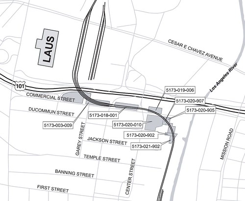 |
|
|
|
Post by James Fujita on Nov 30, 2009 1:26:49 GMT -8
Fukui Mortuary is at the corner of Temple and Vignes, a couple of blocks north of the Nishi Hongwanji.
It would not be affected by the route map that Justin Walker provided, but it would be dangerously close to any diagonal run-through routing that we might attempt.
I think it's safe to say that while the 2005 Metrolink run-through track proposal would be perfectly acceptable, any route that compromised the mortuary would be as dead upon arrival as Fukui's customers.
|
|
|
|
Post by kenalpern on Nov 30, 2009 1:38:39 GMT -8
Pun intended, James?
|
|
|
|
Post by jeisenbe on Nov 30, 2009 11:47:32 GMT -8
Justin, the 2005 route plan would be much curvier, but I suppose it would require buying fewer properties. HSR might need a larger curve radius. I hope Metrolink and CAHSR get together and make a good plan, since CAHSR will have to have run-thru tracks to run trains down to Anaheim in the initial segment.
|
|
|
|
Post by James Fujita on Nov 30, 2009 14:56:41 GMT -8
Yes Ken, very much so  back to the discussion: I've noticed a recurring theme in local rail transit planning, which is that planners seem willing to accept a somewhat curvier route over a straighter one, if that route will avoid angering neighbors or keeping eminent domain to an absolute minimum. It's a strategy worth pursuing when possible, especially when the Los Angeles Times still receives anti-rail letters such as this one.It's interesting to note that the Little Tokyo community is keeping an eye on high-speed rail as well as on light rail.The following is from Little Tokyo Unblogged: It's really not that great of an idea to have high-speed rail going very fast through the center of a city anyways, and considering that trains will have just entered or exited Union Station, I suspect that the curvier route will not have a strong effect on the CalHSR project. However, it will provide a lot of reassurance for the local community, and CalHSR needs as much community support as it can get. Let the people have their S curves. It is far more important that we make sure that these projects (Regional Connector, Run-Through Tracks, Cal HSR) get built at all. |
|
|
|
Post by Justin Walker on Nov 30, 2009 17:19:23 GMT -8
It's interesting to note that the Little Tokyo community is keeping an eye on high-speed rail as well as on light rail.The following is from Little Tokyo Unblogged: It's really not that great of an idea to have high-speed rail going very fast through the center of a city anyways, and considering that trains will have just entered or exited Union Station, I suspect that the curvier route will not have a strong effect on the CalHSR project. However, it will provide a lot of reassurance for the local community, and CalHSR needs as much community support as it can get. Let the people have their S curves. It is far more important that we make sure that these projects (Regional Connector, Run-Through Tracks, Cal HSR) get built at all. It is important to note that the Run-through Tracks and the CA High-Speed Rail project are unrelated projects. The Run-through tracks will accommodate Amtrak & Metrolink just fine but the HSR line would need its own alignment. (Remember, there will be NO track-sharing between Amtrak/Metrolink and HSR trains between LA and Anaheim. The preferred alignment as of July is as shown (click to view PDF plans): 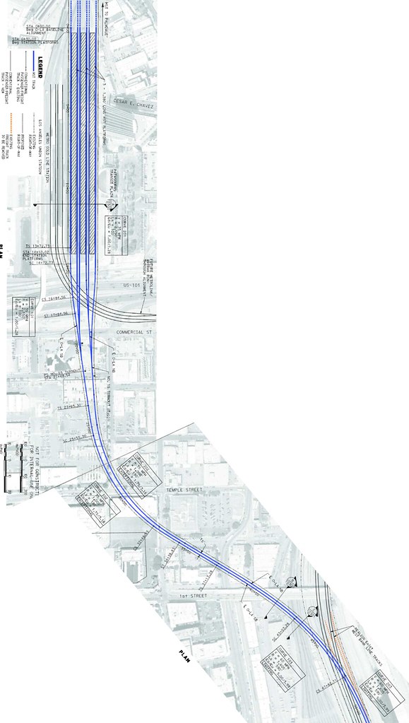 |
|
|
|
Post by James Fujita on Nov 30, 2009 19:54:17 GMT -8
That is a fascinating map, Justin and thank you for posting it.
However, I can't quite tell where Vignes is on that map. If Vignes is where I suspect it is, then I can see how Little Tokyo might have been concerned. The map appears to "thread the needle" between the Nishi Hongwanji temple (to the south and west at First Street) and the Fukui mortuary just to the north at Temple.
Of course, that map is only accurate up to July 2009. I'm curious to know what the more recent and more easterly approach that Little Tokyo Unblogged mentioned would be.
I know there will be no track-sharing (there's none in Japan), but one would hope that there could be right-of-way sharing (which they have plenty of in Japan).
|
|
|
|
Post by jeisenbe on Nov 30, 2009 20:24:07 GMT -8
James, the HSR alignment you show was what I was thinking of when I drew my map. It appears they are planning to elevate the HSR station above the current tracks (since the HSR and Metrolink tracks cross in the diagram, they should be at different elevaltions). That will be more expensive, but it will leave plenty of room for Metrolink and HSR expansion. Based on the pdf James linked to, the HSR tracks would be 32 feet above the Metrolink station. It appears the HSR alignment also avoids the Mortuary, though it would have very high elevated tracks across the street. As long as we are building all these elevated tracks thru the area, we really should get two more tracks put in for future Metro expansion. If he only get the 4 tracks (2 for Metrolink, 2 for HSR) it would make more sense to put them in the same alignment, side-by-side or double-decked, rather than having the Metrolink tracks curve thru another set of properties. However, I would like to see another platform and north-south alignment reserved for Metro. We will definitely want another transit line thru Union Station in the future, even if not for another 30 years, and it will be difficult to shoe-horn in more tracks if we don't plan ahead. The best place for another metro line would be just east of the current Gold Line, to make transfers and routes simpler; the current platforms can reasonably handle only one more line. There used to be room for two more tracks and a platform to the west, but now there is a condo in the right-of-way to the north that would need to be partially demolished; buyer beware: maps.google.com/maps?f=q&source=s_q&hl=en&geocode=&q=Los+Angeles,+CA&sll=33.778184,-118.171048&sspn=0.008097,0.013797&ie=UTF8&hq=&hnear=Los+Angeles,+California&ll=34.059193,-118.233941&spn=0,359.993101&t=h&z=17&layer=c&cbll=34.05746,-118.234855&panoid=VGu5MLYKV0yrgUaXq3G4TA&cbp=12,155.59,,1,-40.77 |
|
|
|
Post by James Fujita on Dec 1, 2009 3:06:50 GMT -8
first, a small point of clarification: The map was posted by Justin Walker, not me. Nothing personal, but it's odd how we can discuss the minutae of rail transit and somehow still manage to get basic stuff like names wrong regarding Cal HSR: if it were possible, I would prefer that both Cal HSR and Metrolink follow the river route and curve around the edge of the neighborhood. Eminent domaining those buildings would be easier than eminent domaining down through the middle. However, I suppose it is possible that Cal HSR can't handle those tighter curves as well as Metrolink can. In which case, I would actually prefer to see Metrolink curve around and have just Cal HSR take the other route. Somehow, having four tracks side-by-side (or even double-decker) in that neighborhood just doesn't feel right to me, especially if it would be close to Nishi Hongwanji. As for Union Station: I don't know about another set of light rail tracks. Let's suppose a second downtown connector gets built 30 years from now. There's no reason why that train would have to go to Union Station. There are many areas and streets in downtown that might want or deserve a train, and strategically, it might be better to weave a web than to have all rails lead to the same place. Union Station is a very valuable link, but with the Red Line and Gold Line already there, we should look into other links as well. |
|
|
|
Post by metrocenter on Dec 1, 2009 11:35:46 GMT -8
It makes one wonder what would happen if, all of a sudden, all these separate agencies and entities (Metro/Metrolink, Cal HSR, CalTrans, Amtrak, BNSF) could actually work together to create unified plan and a coordinated set of bridges crossing the 101 freeway, headed toward the L.A. River.
It makes the mind reel.
|
|
|
|
Post by James Fujita on Dec 1, 2009 13:31:00 GMT -8
It makes one wonder what would happen if, all of a sudden, all these separate agencies and entities (Metro/Metrolink, Cal HSR, CalTrans, Amtrak, BNSF) could actually work together to create unified plan and a coordinated set of bridges crossing the 101 freeway, headed toward the L.A. River. It makes the mind reel. It might be easier if Metrolink/Amtrak operated equipment that was similar to Metro, or even equipment that was similar to Cal HSR — that is to say, electrified. Electric may not be silent, but it would be quieter than diesel, which might make it more acceptable to Nishi Hongwanji, etc. Actually, if there's to be any sort of coordination between Metro, Metrolink and Amtrak, I'd rather see it in TAP card usage. |
|
|
|
Post by bluelineshawn on Dec 1, 2009 20:26:27 GMT -8
The agencies are coordinating. Read the CAHSR documents for proof. They are coordinating with Metrolink, OCTA, LACMTA,, Amtrak, BNSF, etc, etc. But there's only so much that can be coordinated when everyone has plans with no funding.
If/when HSR is built between LAUS and ARTIC, I would think that Metrolink and Amtrak will seriously consider electrification. HSR will most likely still need it's own tracks since they are using non-FRA compliant trains.
|
|
|
|
Post by jeisenbe on Dec 2, 2009 0:15:16 GMT -8
Sorry Justin; thanks for the maps. I had not looked thru the detailed alignment before. I did not realize they already had a workable plan with elevations and all that. I suggest anyone interested in HSR and Metrolink click thru to the link Justin posted: www.cahighspeedrail.ca.gov/images/chsr/20090701145146_AppendixE.pdf#page=23. I am glad to see that metrolink/amtrak will not be left at grade. For the most part, the grade-crossings will be fixed by having the streets go under the rails, rather than the other way around. However, they plan for the high-speed tracks to be to the left or right of the 2 to 4 standard tracks. The Caltrain route in the penninsula is wider and has very little freight traffic, so they are planning to do it right up there: HSR gets two tracks (the middle two is the current plan) and Caltrain will be electrified and will use the two outer tracks. However, Caltrain is also planning on running non-FRA compliant (that is, light-weight and efficient) trains or EMUs. In the event of problems on one track, like a stalled train, Caltrain and HSR might be able to share a few tracks and work around the problem, if they get things worked out, and get a waiver from the FRA (which Caltrain needs to electrify anyway) Metrolink needs electrification, but those plans are far off, and there is a lot of freight on that corridor. I understand it will be easier for HSR to put a concrete barrier between their two tracks and the 2 to 4 tracks for Metrolink and freight. But if the four tracks were more integrated, Metrolink could more easily run regional express trains on the HSR tracks. Especially on the LAUS- Anaheim segment, where HSR is unlikely to run more than one train per 30 minutes each way in the near-term, there would be plenty of room on those new tracks for "local" trains, with stops at Fullerton, Norwalk, and Commerce (every 4 miles). I wish someone here could look at the Metrolink compatibility issues more closely. The CAHSR blog does a good job of dealing with the issues with the route in Nor Cal, and there is even a Caltrain HSR Compatibility blog ( caltrain-hsr.blogspot.com/. We could use a "Metrolink HSR Compatibility blog". |
|
|
|
Post by metrocenter on Feb 8, 2010 15:38:43 GMT -8
The following story appeared last week in blogdowntown.com. In a nutshell, this will add the newest option for the Regional Connector (tunneling under 1st/Alameda) to the list of alternatives for consideration. Underground Connector Up for Metro OKBy Eric Richardson
Published: Tuesday, February 02, 2010, at 01:18PMDOWNTOWN LOS ANGELES — A popular plan to take Metro's proposed Regional Connector light rail link under the intersection of 1st and Alameda will be officially considered by the agency's planning committee this month. First presented to the Little Tokyo community in November, the underground option must be formally added to the two currently being studied in the project's environmental documents. The project would link the two pieces of the existing light rail network, bridging the gap between the 7th / Metro terminus used by the Blue and Expo lines with the Gold Line's Little Tokyo / Arts District station. Two plans currently under consideration both involve at-grade links to the existing Gold Line tracks, an option that the community has been consistently against since the project outreach first started in late 2007. The new alternative could add up to $200 million onto the project's price tag, which would then total roughly $1 billion. Project staff will present the new option to the Planning and Programming committee on February 17 18. The Metro board will officially select a "Locally Preferred Alternative" for the project this summer. Update (Friday): Committee meeting was moved back a day, to February 18. |
|
|
|
Post by darrell on Feb 12, 2010 19:16:53 GMT -8
Next Thursday's Metro Planning and Programming Committee agenda includes the staff report on adding the Fully Underground LRT Alternative, including a fuzzy black and white map. Here's the Agenda description; follow the link above to read the staff report. 33. APPROVE one additional “Build Alternative” for study in the Regional Connector Draft Environmental Impact Study/Report.
The additional “Build Alternative” is a Fully Underground LRT Alternative (Little Tokyo Variations 1 and 2) – underground alternative via Second Street and under First and Alameda Streets. This alternative would be in addition to the Metro Board’s previous approval to include: the “No Build”, TSM, and two build alternatives. |
|
|
|
Post by darrell on Feb 12, 2010 19:38:25 GMT -8
And here's Metro's 2/1/10 news email. The "Metro successfully revisited the alternative and diligently worked to address and minimize previously identified constraints." means they read Gokhan's idea here last November of how to fit a portal and ramp north of Temple. Regional Connector E-Bulletin – February 2010
Happy 2010! We appreciate your valuable input in the Regional Connector Transit Corridor project thus far. We look forward to your ongoing participation so that we can continue to address issues in a timely way and consider project refinements that are supported by the community.
Latest News
As we move into the second month of 2010, we would like to share some project updates with you. You may recall that Metro has, to date, studied four alternatives as part of the Draft Environmental Impact Statement and Report (Draft EIS/R): the required No Build and Transportation Systems Management (TSM) alternatives, as well as an at-grade emphasis alternative via Flower and; 2nd Streets with a couplet on Main and Los Angeles Streets, and an underground emphasis alternative under Flower and 2nd Streets crossing 1st and Alameda Streets at-grade.
During the Alternatives Analysis process a fully grade-separated underground alternative was identified and studied. However, it was ultimately eliminated due to physical constraints and impacts the alternative would have had on the community. During the scoping period, we heard from many in the community about the desire and need for a fully grade-separated alternative which would specifically address concerns regarding the intersection of 1st and Alameda Streets. In response to community concerns, Metro successfully revisited the alternative and diligently worked to address and minimize previously identified constraints.
In close coordination with the Little Tokyo community and other project stakeholders, Metro is now working to develop a fully grade-separated alternative for consideration. The conceptual alternative was presented to the Little Tokyo Community Council on November 24, 2009, and Metro is continuing to refine this option further.
The primary features that distinguish the fully grade-separated alternative from the underground emphasis alternative are as follows: - Trains would pass under the intersection of 1st and Alameda Streets. One set of tracks would surface continuing east, allowing trains to travel east- or west-bound on the Gold Line alignment. The other set of tracks would surface to connect to the existing Gold Line bridge over the US-101 Freeway. This would allow trains to continue traveling north- or south-bound on the Gold Line alignment.
- The existing at-grade station in Little Tokyo/Arts District would be relocated. A new station would potentially be located below ground level within the property currently occupied by Office Depot and other small commercial uses.
- A proposed station at 2nd Street and Broadway would be located under 2nd Street between Broadway and Spring Street.
- No Underpass or Pedestrian Bridge would be constructed at 1st and Alameda Streets, because no new at-grade tracks would be added to the intersection.
You can view Metro’s Blog posting about the alternative by following this link.
A fully grade separated alternative would need to be formally added to the Draft EIS/R, while the initial four alternatives will continue to be studied as part of the environmental process. Metro staff will make the formal request to include the additional build alternative in the EIS/R at Metro’s February 17th Planning and Programming Committee meeting.We encourage your attendance and your comments at this meeting.
In advance of this meeting, you are welcome to submit comments on the potential addition of the fully grade-separated alternative by email: regionalconnector@metro.net.
Next Steps
As the environmental studies continue to move forward, Metro anticipates hosting a series of community update meetings during April 2010. Metro staff is looking forward to providing you with an update on the progress of the technical studies, presenting the fully grade-separated alternative, and presenting any new information for community review.
Metro anticipates releasing the Draft EIS/R document during Summer 2010. The Draft EIS/R analysis will include a description of construction processes and potential mitigation measures. A set of public hearings will be scheduled to solicit feedback from the community regarding the findings of the study. The Final EIS/R will be available for community review during Fall 2011, where Metro will again solicit community feedback. The Final EIS/R will designate a Locally Preferred Alternative.
Stay in Touch!
For additional information or questions, to learn about upcoming meetings or to sign-up for study updates, please go to www.metro.net/regionalconnector or contact the project information line at 213.922.6934. You can also find us on Facebook at “Metro Regional Connector”, and feel free to email us at regionalconnector@metro.net
Another Thank You
Metro would like to again thank everyone who has provided comment on the Regional Connector Transit Corridor Study. Metro is listening, and will continue to listen as the study progresses through the planning process. Here's Metro's map from last November again: 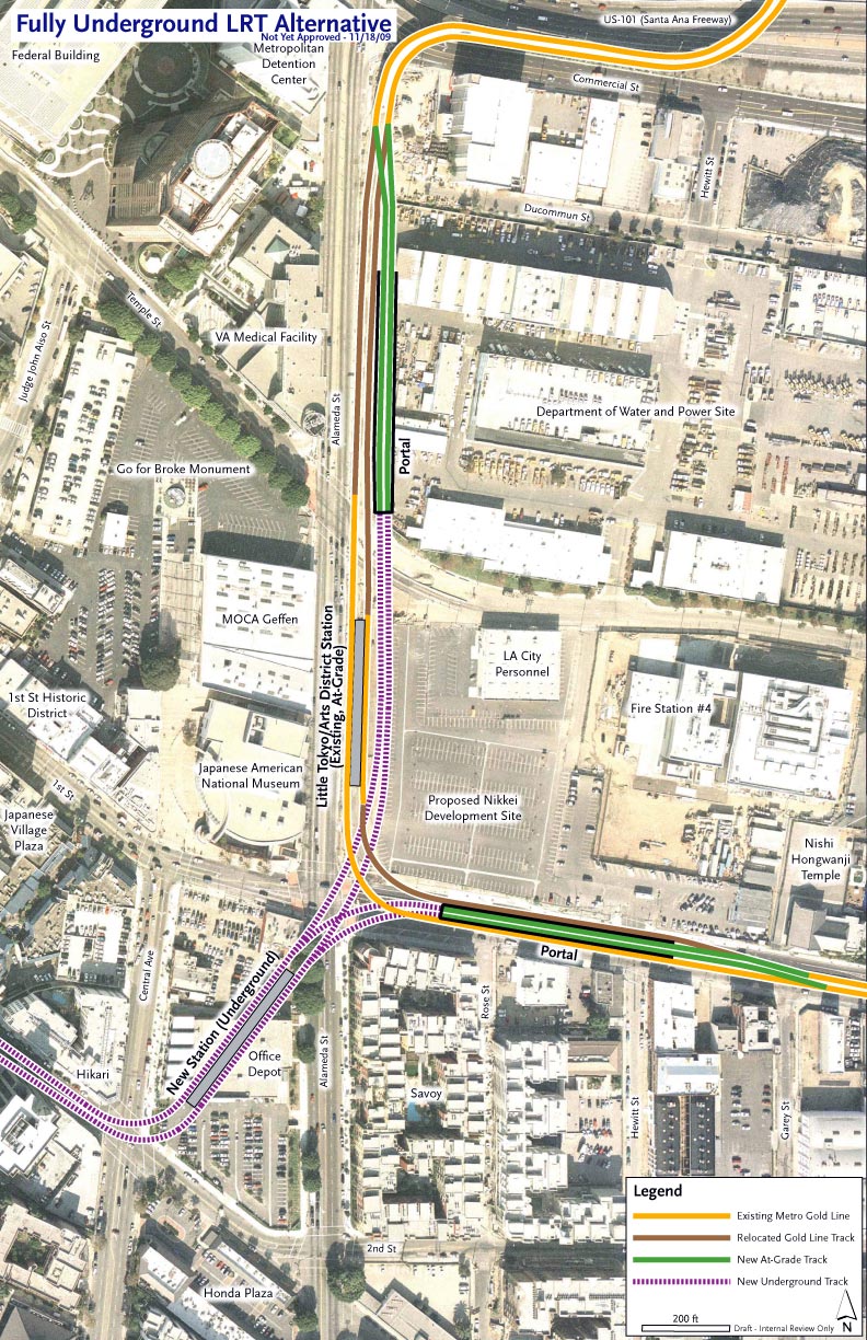 |
|


