|
|
Post by TransportationZ on Jan 29, 2012 17:36:36 GMT -8
Hello, First Post. maps.google.com/maps/ms?msid=205119005670644179646.0004b72aeaecc101662af&msa=0&ll=33.916013,-117.997971&spn=0.430781,0.594635 With the Western half the county getting the Crenshaw Line, Van Nuys, Sepulveda Pass, and the South Bay extension, I was surprised there is not crosstown North South LRT Planned. Rosemead/Lakewood corridor is perfect because: -ROW to Gold Line Foothill corridor is wide enough for a connection. -This connection could then continue west as the Burbank Glendale LRT, splitting from the gold line again between Memorial Park and Del Mar. -Hits all major metro rail stations, with a possible connection to the El Monte busway(if possible) -As well as hitting the Gold Line, El Monte Busway, Eastside Gold Line, AND Green Line, It would also hit the Lakewood center and Long Beach airport, while bringing much need LRT service to the eastern side of Long Beach. |
|
|
|
Post by James Fujita on Jan 29, 2012 19:27:52 GMT -8
I'm more familiar with the south end of this route than the north end, so I'll limit my comments to the south end:
- At the Long Beach traffic circle, I would veer off to serve the students of Long Beach State, rather than head south to Belmont Shore.
- Long Beach already has pretty decent bus service to Belmont Shore in the form of the Passport shuttle. The Ocean Boulevard route would be a better candidate for a streetcar than a light rail line.
|
|
|
|
Post by TransportationZ on Jan 29, 2012 19:49:13 GMT -8
I'm more familiar with the south end of this route than the north end, so I'll limit my comments to the south end: - At the Long Beach traffic circle, I would veer off to serve the students of Long Beach State, rather than head south to Belmont Shore. - Long Beach already has pretty decent bus service to Belmont Shore in the form of the Passport shuttle. The Ocean Boulevard route would be a better candidate for a streetcar than a light rail line. I love the passport bus. While yes, I wanted to get to CSULB, Connecting to the Blue line is far more important, unless you go to CSU, then circle back around onto ocean. Otherwise, you are creating yet another critical 3 mile gap in the system. It HAS to reach the Blue Line. EDIT: Also, the Passport D already goes to CSULB, just give students a Passport Shuttle from Traffic Circle or 7th street station. EDIT2: There just isn't enough going on on Ocean to warrant a streetcar. 4th Street would be a better candidate, or even better a 2nd Street Streetcar from the Second street LRT station East to 2nd/PCH. |
|
|
|
Post by James Fujita on Jan 30, 2012 2:02:06 GMT -8
Given our current lack of funding, any rail line which we are to consider seriously needs to aim for the highest possible ridership, and not just be linking together points on a map.
CSULB, like many Cal State campuses, is a commuter campus. It would provide many more potential riders than Belmont Shore. I like Belmont Shore, but I don't see it generating enough traffic to be seen as a light rail-friendly destination.
I honestly don't see why it has to link with the Blue Line. If it links with the Green Line, people would be able to make a Blue-Green-Lakewood transfer.
Even if you want an east-west route in Long Beach, there are routes which would be better than the Ocean Boulevard route. A more inland route, while less scenic, would draw more riders. Anaheim or PCH would be sufficient.
I suggested a streetcar for Ocean Boulevard because I know that's the route that the Passport takes, your map specifically mentioned Ocean, and I think streetcar would be a better fit than light rail on that route. Assuming that Long Beach was even interested in such a thing in the first place.
|
|
|
|
Post by hooligan on Jan 30, 2012 11:56:40 GMT -8
Hello, First Post. maps.google.com/maps/ms?msid=205119005670644179646.0004b72aeaecc101662af&msa=0&ll=33.916013,-117.997971&spn=0.430781,0.594635 With the Western half the county getting the Crenshaw Line, Van Nuys, Sepulveda Pass, and the South Bay extension, I was surprised there is not crosstown North South LRT Planned. Rosemead/Lakewood corridor is perfect because: -ROW to Gold Line Foothill corridor is wide enough for a connection. -This connection could then continue west as the Burbank Glendale LRT, splitting from the gold line again between Memorial Park and Del Mar. -Hits all major metro rail stations, with a possible connection to the El Monte busway(if possible) -As well as hitting the Gold Line, El Monte Busway, Eastside Gold Line, AND Green Line, It would also hit the Lakewood center and Long Beach airport, while bringing much need LRT service to the eastern side of Long Beach. .. You'd have issues in Downey. First the Nimbys. And they are probably 80 percent complete with the repaving and widening project of Lakewood Boulevard they basically widened it three lanes north and south and added a median. there is a row South of the 105 that would be ideal and can take you all the way to LB airport. i have a gateway cities map i created. One of my spokes goes to long beach Ariport you could probably extend the line to Cal state Long Beach but i could see bus Service connecting the university to the airport. g.co/maps/hfm2t |
|
|
|
Post by bobdavis on Jan 30, 2012 12:56:27 GMT -8
Rosemead Blvd. in my area (Pasadena-Temple City-Rosemead) has been undergoing lots of repairs/upgrades for the last few years. Every time I see crews out working on the median (often closing lanes in the process), I think, this disruption would be a lot more tolerable if they were installing railroad tracks for a light-rail line. Right now, all we have is a bus line with 30 to 40 minute headways--not the sort of service that inspires people to use transit. But with Expo II, Crenshaw, Sepulveda/Van Nuys, Downtown Connector and a few other projects ahead of it, the Rosemead-Lakewood Line is definitely in the "I should live so long!" or "sometime between now and when the Devil hosts the Winter Olympics" category.
|
|
|
|
Post by bzcat on Jan 30, 2012 14:52:39 GMT -8
I like the overall concept of this line but I also think ending the line at CSULB is more attractive option than ending at Blue line. It will likely generate more transit trips if the line ends at CSULB. Not much transfer demands exist between this proposed route and the Blue line. As it is sketched out, the entire line will be build over existing roadways, which means it will be very messy fight with NIMBY of various stripes. Also, depending where Gold line East side extension is located, I think there may be benefit of routing this N-S rail line to Montebello rather than continue on Rosemead between Beverly and 10 freeway. The Whittier Narrow Recreation Area is popular on the weekends but a dead zone during the week. That portion of the rail line is going to kill the line for Federal funding purpose due to low ridership. I would prefer an alignment using Montebello Blvd and San Gabriel Blvd in the middle portion of this line. Also, I would end the line at Arcadia station rather than Sierra Madre Villa. maps.google.com/maps/ms?msid=200920330746408617074.0004b7c6bc339d81ab9e8&msa=0&ll=33.956461,-118.088608&spn=0.377608,0.727158 |
|
|
|
Post by TransportationZ on Jan 30, 2012 15:49:23 GMT -8
Given our current lack of funding, any rail line which we are to consider seriously needs to aim for the highest possible ridership, and not just be linking together points on a map. CSULB, like many Cal State campuses, is a commuter campus. It would provide many more potential riders than Belmont Shore. I like Belmont Shore, but I don't see it generating enough traffic to be seen as a light rail-friendly destination. I honestly don't see why it has to link with the Blue Line. If it links with the Green Line, people would be able to make a Blue-Green-Lakewood transfer. Even if you want an east-west route in Long Beach, there are routes which would be better than the Ocean Boulevard route. A more inland route, while less scenic, would draw more riders. Anaheim or PCH would be sufficient. I suggested a streetcar for Ocean Boulevard because I know that's the route that the Passport takes, your map specifically mentioned Ocean, and I think streetcar would be a better fit than light rail on that route. Assuming that Long Beach was even interested in such a thing in the first place. So you are saying connectivity is not important at all as long as it hits a high ridership generator. Noted. I saw an extended Green/Crenshaw Line through the South Bay to Long Beach heading east past the Blue Line on PCH ending at CSULB. Not a Lakewood Line. Though it should depend on the demographics of where the majority of students are coming from to see if an E-W or N-S ending CSULB is more convenient. I actually agree about PCH and Anahiem as better routes. My aim was not specifically to connect to Belmont shore-my aim was to not leave our system with yet another gap. Great for CSULB students but for the rest of us you would plopped right in middle of CSULB with no connection to Downtown or the rest of Long Beach for that matter. And I'm 100% sure a good portion of CSULB stupdents aren't just going North of the campus. I think my map made gave you the impression I value Belmont shore over CSULB - which I don't. |
|
|
|
Post by James Fujita on Jan 30, 2012 16:10:46 GMT -8
EDIT: If a South Bay to Long Beach to CSULB branch got built, the Lakewood Line could dead-end at the Traffic Circle. I see nothing wrong with transfers. If necessary, build a wye.
Secondly, connectivity is important, but it is not everything. If the Purple Line extended to Santa Monica, it is not a sure thing that it would link up with the Expo Line.
EDIT: Responding here more to bzcat, Bob Davis and hooligan than to c40lfr in this post:
The problem is, we really are running out of old PE separated ROWs that we can grab without too much trouble.
Also, the residential vs commercial/ industrial nature of some of the old ROWs have definitely changed over the years, meaning that a ROW that might have once made sense now makes less sense. You can even see that with some of the Blue Line stops, where the primary destination appears to be a zipper factory.
In the future, we will be facing more and more "roadway routes" and potential NIMBY trouble to varying degrees. As we have seen with the Purple Line, some of the more desirable locations (Century City) may be surrounded with the biggest NIMBYs (Beverly Hills).
We have to recognize that road routes will be either 1) slow because of street rules, 2) expensive because of tunneling 3) attract NIMBYs if elevated. That doesn't mean we avoid such routes, but these are potential problems.
However, I don't want to discourage c40lfr or others from coming up with imaginative or creative maps, even if they are unlikely to get built soon. This is The Dream section of the message board.
There's a part of me which finds the idea of rail from downtown Long Beach to Long Beach Airport or CSULB to be very attractive. But, we have to be more realistic.
|
|
|
|
Post by jdrcrasher on Jan 30, 2012 21:17:49 GMT -8
At first I thought I created this thread!
I think the South Bay-Long Beach-CSLB line should get to CSLB by veering on the old PE ROW after it crosses the Blue Line, jumping on Anaheim, tunneling under Park Estates, and emerging under Beach Dr. This goes through a denser area than Traffic Circle (I originally wanted it to go there, though).
I also think the the ROW to Long Beach Airport would be better used as a Metrolink line to establish Union Station-Long Beach service. If there is ever Metrolink via the Harbor Subdivision, it likely won't get farther than LAX.
|
|
|
|
Post by carter on Jan 30, 2012 22:13:56 GMT -8
I think it's also important to think about what employment centers any proposed line would connect. Here's a handy map: 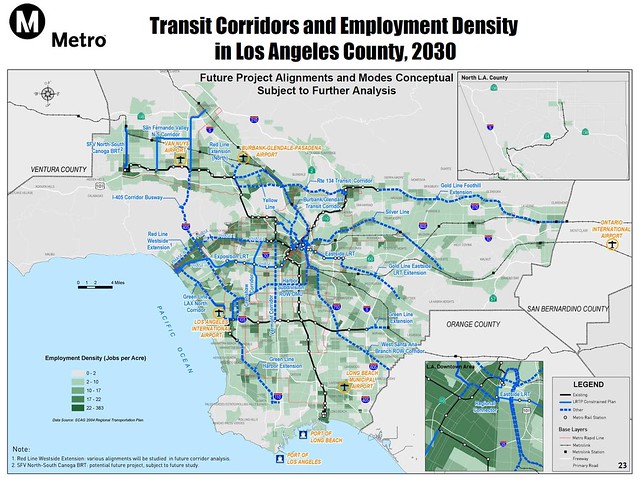 Unfortunately, this line appears to be a low-performing line in the employment respect, so it's probably going to have to take a back seat to a number of other worthy but un-funded projects, like an extension of the Crenshaw line to the Purple and Red Lines, a Vermont Blvd line, or a NoHo to Pasadena Line. That said, this is "The Dream" thread, so keep dreaming! |
|
|
|
Post by TransportationZ on Jan 30, 2012 22:33:00 GMT -8
I think it's also important to think about what employment centers any proposed line would connect. Here's a handy map: Unfortunately, this line appears to be a low-performing line in the employment respect, so it's probably going to have to take a back seat to a number of other worthy but un-funded projects, like an extension of the Crenshaw line to the Purple and Red Lines, a Vermont Blvd line, or a NoHo to Pasadena Line. That said, this is "The Dream" thread, so keep dreaming! Actually this map shows even more the need for this line. You will have all these lines to eastern side of LA County(Foothill extension, East LA Gold Line, etc) but you still have to go through the blue line to access the projects. There is no crosstown line. You would suffer from the same problems that plague NYC. For example, sure the bronx has 6 subway lines, but they are ALL going N-S, leaving crosstown bus routes crush loaded. You can't go from say East LA to Montclair w/o backtracking ALL the way back to downtown LA. IMO, they are leaving the eastern half LA Country dry with no N-S Service. Making everyone take the blue line for all N-S movements is going to prove to be a bigger problem later. |
|
|
|
Post by jdrcrasher on Jan 31, 2012 8:30:01 GMT -8
^ This is probably the biggest benefit of a Lakewood/Rosemead corridor line. It also strengthens the case for the 405 corridor.
Btw, what's up with shooting range in Whittier Narrows? You know,that piece of land southwest of Rosemead at the 10 freeway? Is it still in operation? If not, who owns the land? I know some native american tribes own some land nearby.
|
|
|
|
Post by matthewb on Jan 31, 2012 9:13:48 GMT -8
IMO, they are leaving the eastern half LA Country dry with no N-S Service. Making everyone take the blue line for all N-S movements is going to prove to be a bigger problem later. It sounds like once that happens, there could be momentum to get funding to move this from the dream section to reality. It's a good idea, and I think that additional transit further East is a logical extension once the main job centers (west side) and highest population density areas are served. |
|
|
|
Post by Gokhan on Jan 31, 2012 10:03:40 GMT -8
The right-of-way seems to be 100 ft or wider everywhere. Therefore, from a technical point of view, it should be possible to maintain two lanes in each direction and have at-grade LRT. The right-of-way checks good!  |
|
|
|
Post by bobdavis on Jan 31, 2012 15:29:39 GMT -8
North-south service in the San Gabriel Valley was one of the glaring weaknesses of the PE--one could just about walk from Glendora to Covina in the time it would take to ride the Red Car from Glendora to Valley Jct. (just east of County USC Medical Center) and then backtrack on the San Bernardino Line. After World War II, there was a one-man bus line running from downtown Monrovia to the PE station in El Monte. Business grew to the point where the owner-operator bought another bus and hired a driver for it. The big problem was that the owner didn't have the resources to run a background check on the new man, and find out WHY he was available. One of my mother's friends told me about riding the bus out of Monrovia with the hired driver at the wheel. They came to the Santa Fe tracks where the driver ignored the operating wigwag signal and crossed just before the Santa Fe "Chief" roared through the crossing. It wasn't until the 1960's that the SCRTD started adding a comprehensive set of crosstown lines out my way.
|
|
|
|
Post by gibiscus on Nov 24, 2012 13:52:20 GMT -8
I was thinking of a line similar to this, starting at Sierra Madre Villa station, then east on Foothill, south on Rosemead (stops @ Colorado, Huntington and Las Tunas [Temple City]), west on Las Tunas (stops at San Gabriel Blvd, Santa Anita [Downtown/Mission SG] and Garfield [Downtown Alhambra]), south on Atlantic (stops at Valley, Garvey [Monterey Park], Cesar Chavez [ELAC], Pomona/Beverly/Eastside Gold Line and Whittier), southeast on Telegraph (stops at the Citadel and Commerce Casino), south on Garfield (stops at Slauson, Florence, Firestone, Imperial), then south on the RR ROW east of Garfield (stops at Century/Green Line, Rosecrans, Alondra, Artesia and South), then via the branch going southwest (stop at Orange), south on Atlantic (stops at San Antonio and Bixby), west on Wardlow (stop at Long Beach) and then south on Long Beach Blvd, joining the Blue Line at Willow and continuing to downtown LB...
|
|
|
|
Post by gatewaygent on Nov 24, 2012 20:38:31 GMT -8
Hmm? The line you describe seems a little zig-zaggy. It's not to say that it couldn't become a successful line. However, it seems as though it would be better to implement lines on Main St./Las Tunas Dr., Garvey Av., Randolph/Whittier ROW, and Atlantic Av. (These four probably won't occur in our lifetimes, if at all.) Moreover, this isn't even including the West Santa Ana Branch/PEROW and the Blue Line extension to Cal State Long Beach which are in the LRTP 2009 + Supplement #1 respectively.
|
|


