|
|
Post by JerardWright on Jun 2, 2017 6:04:34 GMT -8
Interesting.... for the "blue" Whittier line, there are a few issues. Actually landscaped medians is what killed the alignment down Beverly Blvd. City of Montebello just spent a lot of local dollars to build and maintain landscaped medians along Beverly Blvd and they did not want that impacted at all through a LRT at grade alignment even though that was one of the highest ridership corridors. The ROW through Whittier has already long been built as the Greenway Trail, and Whittier is committed to it - they paid for a bridge replacement over Pickering for the original construction and have just bought an easement to extend it from Mills Ave to the far eastern city line. It's also quite narrow through Uptown, and crosses a bunch of small residential streets. That is true but there has been little consideration to actually widening and improving that section or at least build a separation as it goes through the Park for both transit/bike/equestrian. It crosses a bunch of smaller streets to get to where the actual demand and more centralized destination should be to serve Whittier where you want ridership. The northern section is already being looked at for a Metrolink stop near Rio Hondo College. What might be more workable is to zig-zag it on the surface along the UP right-of-way to Garfield to Washington Blvd. Surface station at the Citadel as you say. These are very busy streets with heavy truck traffic, so getting Commerce to OK it might be an issue. The core of using the ROW is to save dollars and enable both South El Monte and Whittier to be served at the same time because the ROW serves both and limit branch operation issues as it is currently a problem with both the SR 60 and Washington Blvd alignments as they are too far a part to be useful but too close together to which they cannibalize each other in ridership with the split. I'd almost want to throw another bone here and that is to turn SR-60 alignment into an express lanes and have BRT service with a dedicated station at the Shops at Montebello and around Rio Hondo College/Peck Road to operate express Silver Line like service to more of the Eastern San Gabriel Valley more effectively, it would give the SGV taxpayers a solid improvement to the enable faster trips and $$$ to maintain that corridor through the tolling. A transfer can be made at Atlantic with the option to continue the trip up the 710 to connect with the I-10 Express Lanes into Downtown LA, currently Foothill Transit Park and Ride Express lines use the 60 east of the 605, this could open up new ridership opportunities and create an added Silver Streak like service for Foothill that will be useful and popular. |
|
|
|
Post by JerardWright on Jun 2, 2017 6:10:41 GMT -8
It looks to be more expensive to build a subway under Whittier Blvd from downtown thru East LA (all the way to Atlantic?) than just under Atlantic. Also, DTLA utility relocations cost a heck of a lot. I didn't see any guesstimates of cost in Scott's piece. Of course you will never see a cost estimate because that will defy logic of building such pieces. Hell, it would be far cheaper to just upgrade the existing Gold Line as a subway from the East LA side of the LA River to the current Boyle Heights subway (or not and just give full signal synchornization) and then build a new tunnel from Indiana down Whittier Blvd to the proposed junction and split the lines that way to actually solve the core capacity problem through East LA. Agreed, but if they are going for a tunnel, might as well enable the tunnel to be useful and use it for capacity purposes so that more trains CAN run through the alignment. |
|
|
|
Post by bzcat on Jun 2, 2017 11:06:07 GMT -8
|
|
|
|
Post by culvercitylocke on Jun 3, 2017 18:35:23 GMT -8
Hmm I would say a Washington second subway into downtown would be amazing but would never happen. And seems a bad idea to begin it if we're currently building a partially failed subway project (a subway to nowhere instead of to the sea).
But I do think the c line proposednis ridiculous.
Instead they should:
1 . Build out the 60 extension.
2. Build a traditional junction at the point where the two lines merge and have the Washington alignment bend north south to go up Atlantic to Pasadena using 710 money. So you have a north south line that then bends onto Washington for that "extension "
Then if the fabled WSAB ever gets built you could extend south the north south line to meet it as proposed on the urbanize link.
|
|
|
|
Post by bzzzt on Jun 4, 2017 9:41:58 GMT -8
That is true but there has been little consideration to actually widening and improving that section or at least build a separation as it goes through the Park for both transit/bike/equestrian. It crosses a bunch of smaller streets to get to where the actual demand and more centralized destination should be to serve Whittier where you want ridership. Not sure which park you're talking about - Palm Park in Whittier? The Greenway ROW there could be widened, but it's places on the Trail near Broadway and near Pioneer where the ROW's single-track width would mean either throwing out any landscaping, or using property takes to get enough space for LR plus a landscaped bike/walk lane. Even then, I'm not sure if there's enough separation (legally) between the LR and pedestrians. If the ROW had been double-track, or if it had been in an industrial zone, it'd be a different story... I just don't see the city council supporting that - they'd rather go with an alternative. The more practical way to go through Whittier is along the Greenway trail along Lambert, starting at Washington - which is also the end of Metro's GLEE line 'B'. The ROW there is wide enough, but the ridership wouldn't justify building it until the area densifies. Another possibility is widening Whittier Blvd (with property takes) from the 605 to where it widens at Philadelphia as car traffic might necessitate it. Run a surface line down Whittier Blvd, and either turn towards uptown on Philadelphia, or, if it isn't sold off already, use the old ROW at the back of Presbyterian Hospital to go to Washington/Lambert, which could then be extended as above. Of course, the best and simplest and expensive way is a subway going down Whittier Blvd from DTLA to Uptown Whittier. Which might be what the politicans are aiming for, but need a stopgap light rail until it's built. |
|
|
|
Post by JerardWright on Jun 9, 2017 18:27:49 GMT -8
The more practical way to go through Whittier is along the Greenway trail along Lambert, starting at Washington - which is also the end of Metro's GLEE line 'B'. The ROW there is wide enough, but the ridership wouldn't justify building it until the area densifies. Another possibility is widening Whittier Blvd (with property takes) from the 605 to where it widens at Philadelphia as car traffic might necessitate it. Run a surface line down Whittier Blvd, and either turn towards uptown on Philadelphia, or, if it isn't sold off already, use the old ROW at the back of Presbyterian Hospital to go to Washington/Lambert, which could then be extended as above. Of course, the best and simplest and expensive way is a subway going down Whittier Blvd from DTLA to Uptown Whittier. Which might be what the politicans are aiming for, but need a stopgap light rail until it's built. 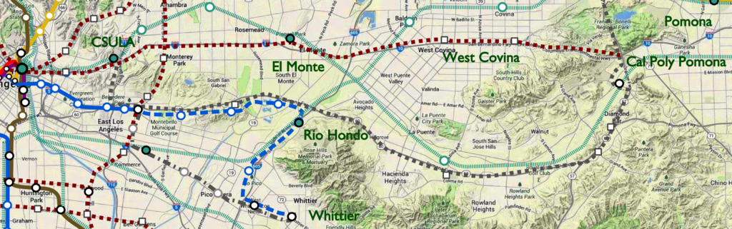 Another all subway solution to a problem when other critical corridors haven't even been completed will send us down the road of fiscal unease during the 1990's. If Metro is going to spend more money to solve a problem let's actually solve the problem in front of us rather than cause a brand new headache and have to cancel other Measure M projects to pay for this. The more I think about it there is really two cost effective ways of solving the problem; 1) Hybrid LRT to Whittier & SR-60 Express Lanes/BRT approach (Silver Lines). Build the LRT via the proposed Citadel/ Washington Blvd to Whittier corridor and BRT service that mimics the Silver Line BRT on the I-10, in the original study BRT was studied but not as an Express Lanes approach. BRT can operate with strategic stations at Atlantic, The Shops at Montebello, Peck Road even around Puente Hills Mall that can be linked to the I-10 Express Lanes via the 710 at CSULA. This will be a better bang for the buck and can serve more of the San Gabriel Valley region and connect directly into Downtown LA and East Los Angeles. Revenues from the toll lanes can upgrade the BRT and station infrastructure and maintain SR-60 for critical Goods Movement and keep operation costs in line with service demands for mostly a commuter style corridor. This can even link with an Atlantic Corridor BRT/Arterial Streetscape improvements for both mobility and economic development. 2) Build both destinations on one corridor (Dashed Blue Line); Build the SR-60 alignment as designed with an elimination of the Peck Road station with a replacement station serving Rio Hondo College near Pico Rivera Sports Arena and continue via railroad ROW parallel to the 605 to Washington or Whittier Boulevards where it then continues to Whittier terminus. The strength here is that every one is served within existing dollars & as an operational advantage that there are no branches it is one solid corridor that will link new destinations on the alignment and utilizes a portion of an existing grade separated Railroad ROW to save on costs and solve an actual problem, you combine this was an added stations with Metrolink at the Citadel and Rio Hondo and destinations can be served throughout the region most cost effectively. In addition, the Randolph UP ROW (a portion of which is utilized for the West Santa Ana Corridor) would be ideal as another link to Downtown LA that would be far more cost effective to implement and tie into the system and preserves ideas for a Whittier HRT subway whenever that gets going. |
|
|
|
Post by bzzzt on Jun 10, 2017 10:50:31 GMT -8
Come on, you know how politics is. You don't cancel it or cancel other projects, you just stretch out the project another ten years to collect revenue.
For 1), you might have a possible solution. However, there is no HOV or carpool lane on the 60 on most of the stretch you're talking about. Metro would need to construct one for BRT to have a chance, using freeway funding for the construction. But this could happen if Metro is willing to backtrack on their LR proposal that they sold as part of Measure M, and and Montebello is alright with it. Montebello might be agreeable, as they would get a wider freeway where there is a lot of traffic congestion.
2) Never liked zig-zags. This route would be good for shoppers going to the Montebello mall. You'd lose a bunch of downtown commuters.
Anyways, w/ regards to the Randolph ROW - if you think UP (or BNSF) will share their ROW (I have my doubts), than I suggest sharing the WSAB line from downtown south to Butte St junction, then running east on the rail ROW past the Citadel, and hopping over to Washington Blvd on a short underground tunnel.
|
|
|
|
Post by JerardWright on Jun 13, 2017 21:43:18 GMT -8
For 1), you might have a possible solution. However, there is no HOV or carpool lane on the 60 on most of the stretch you're talking about. Metro would need to construct one for BRT to have a chance, using freeway funding for the construction. But this could happen if Metro is willing to backtrack on their LR proposal that they sold as part of Measure M, and and Montebello is alright with it. Montebello might be agreeable, as they would get a wider freeway where there is a lot of traffic congestion. The beauty of this is, this is not really a back track this is part of the two branch solution for Eastside Phase 2 AND to manage the congestion on the existing SR-60 corridor with a median HOT lane that can include dedicate BRT infrastructure in the process. Plus the revenues from the HOT can stay along the corridor for more SR-60 improvements, so it is a win-win. You incorporate a P3 solution that helps on the Truck goods movement and you have an economic trade and transit corridor that can be a model of the nation. Actually this would solve a number of issues as the route is as fast or faster as commuters are traveling now as the planned stations along SR-60 are farther apart which can build up considerable operating speed. Plus this "zig-zag" will serve a couple of extra destinations along the way with Rio Hondo College being a key hub that can be included and closer on Whittier Blvd where most of the shopping centers are located and actually gives the SR-60 extension some real ridership and be cheaper to build with actual money left over to improve for example the Whittier Greenway to be extended to the San Gabriel River pathways. The beauty of it is that making Whittier a destination off of SR-60 makes sense as an initial rail corridor to Whittier, as if you are driving you have to do an number of dog-legs to reach Whittier either via the 5, 60 or 605 freeways. This is part of what the Gateway Cities COG have been thinking for a while now as an option to keep on the table to Whittier in case these studies fall apart. |
|
|
|
Post by metrocenter on Jun 14, 2017 9:33:24 GMT -8
<rant>
When it comes to branching, Metro seems to always be operating on a fear of not having balanced branches. I understand there are operational issues when things are unbalanced. But I cannot understand the possible need for a Whittier-to-El Monte boomerang. That is almost guaranteed to have zero ridership.
I would prefer to see the existing Gold Line split at 3rd/Indiana, with the new split coming straight down Indiana to Whittier Blvd, and then heading east. There is tons of ridership in the southern part of East L.A. Do it right, once and for all.
And while they're at it, they could cut-and-cover the short stretch from 1st/Lorena to 3rd/Indiana, like they should've done in the first place. That S-curve has blown up traffic and destroyed the neighborhood.
</rant>
|
|
|
|
Post by fissure on Jun 14, 2017 23:14:18 GMT -8
The reason for the boomerang is to have not-terrible headways along both branches. If Expo stays at 12 minutes off-peak, you're looking at 24-minute headways along each branch, which is godawful for midday light rail. Moving the split west a few miles doesn't change anything. Running one as a shuttle outside of peak (or even during peak) is not going to fly politically, because whoever doesn't get direct service will feel like they missed out.
I wish Randolph Street had been in the study area, since the WSAB tracks will be almost entirely grade separated north of the junction point and should have plenty of capacity (though they might need more than 2 tracks to turn trains at LAUS). It would be a roundabout way to serve Whittier, and Montebello would miss out, but Maywood/Bell/Bell Gardens would be a worthwhile trade. It also still makes sense as a line even if the Whittier Blvd subway gets built.
|
|
|
|
Post by JerardWright on Jun 15, 2017 14:36:27 GMT -8
<rant> When it comes to branching, Metro seems to always be operating on a fear of not having balanced branches. I understand there are operational issues when things are unbalanced. But I cannot understand the possible need for a Whittier-to-El Monte boomerang. That is almost guaranteed to have zero ridership. I would prefer to see the existing Gold Line split at 3rd/Indiana, with the new split coming straight down Indiana to Whittier Blvd, and then heading east. There is tons of ridership in the southern part of East L.A. Do it right, once and for all. And while they're at it, they could cut-and-cover the short stretch from 1st/Lorena to 3rd/Indiana, like they should've done in the first place. That S-curve has blown up traffic and destroyed the neighborhood. </rant> Which Boomerang are you referring to? Mine or Metro's? From a practical standpoint just extending the SR-60 to go to Whittier will hit two key destinations that neither branch currently serves in Rio Hondo College and the Pico Rivera Sports Arena which are good from a ridership perspective and we don't spend a total of $6B to solve, more like an additional $1B for this extension. Because the current dilemma with the two branches is both the operational headache and the cost of building both branches where there is now added a new 2 mile subway that is only increasing ridership by 1500-2000 riders for an added $1B cost, not to mention the operational limitations of the existing alignment has (not because it is at grade) it is because they didn't give the line priority in key sections and that stations are too close together. $2B to $3B saved to actually spend on fixing the operational headaches of the corridor or as seed money towards a suggested Whittier Blvd HRT extension. Like you, I agree if they are going to spend the money here they might as well correct the capacity constraints needed to actually OPERATE both branches or try to solve the problem of serving both destinations with as little extra cost as possible to conserve for more important matters in the subregion. |
|
|
|
Post by bzzzt on Jun 15, 2017 23:19:35 GMT -8
Actually this would solve a number of issues as the route is as fast or faster as commuters are traveling now as the planned stations along SR-60 are farther apart which can build up considerable operating speed. Plus this "zig-zag" will serve a couple of extra destinations along the way with Rio Hondo College being a key hub that can be included and closer on Whittier Blvd where most of the shopping centers are located and actually gives the SR-60 extension some real ridership and be cheaper to build with actual money left over to improve for example the Whittier Greenway to be extended to the San Gabriel River pathways. The beauty of it is that making Whittier a destination off of SR-60 makes sense as an initial rail corridor to Whittier, as if you are driving you have to do an number of dog-legs to reach Whittier either via the 5, 60 or 605 freeways. Well, I wouldn't call Rio Hondo a key hub. You have the college, true, but it's warehouses, a freeway, a river, a closed garbage dump, and a huge cemetery around it. Also, the dog leg would add 5 to 6 miles from the planned terminus at Washington/Whittier towards downtown or East LA. Add in 2-3 stops, and I think it's going to be close to the same times. And you'd be losing ridership that would switch from cars because they're inconveniently far from the freeways along Washington or Atlantic - one reason why the Washington Blvd ridership is greater than the 60 ridership. I'm still of the opinion that the proposed route (the 'c' route seems like a waste of money, though) is the best, although way expensive. If not, build a Silver Line on the 60, or see if LR can be built along the Riverside Metrolink ROW. |
|
|
|
Post by JerardWright on Jun 16, 2017 5:49:45 GMT -8
Actually this would solve a number of issues as the route is as fast or faster as commuters are traveling now as the planned stations along SR-60 are farther apart which can build up considerable operating speed. Plus this "zig-zag" will serve a couple of extra destinations along the way with Rio Hondo College being a key hub that can be included and closer on Whittier Blvd where most of the shopping centers are located and actually gives the SR-60 extension some real ridership and be cheaper to build with actual money left over to improve for example the Whittier Greenway to be extended to the San Gabriel River pathways. The beauty of it is that making Whittier a destination off of SR-60 makes sense as an initial rail corridor to Whittier, as if you are driving you have to do an number of dog-legs to reach Whittier either via the 5, 60 or 605 freeways. Well, I wouldn't call Rio Hondo a key hub. You have the college, true, but it's warehouses, a freeway, a river, a closed garbage dump, and a huge cemetery around it. Also, the dog leg would add 5 to 6 miles from the planned terminus at Washington/Whittier towards downtown or East LA. Add in 2-3 stops, and I think it's going to be close to the same times. And you'd be losing ridership that would switch from cars because they're inconveniently far from the freeways along Washington or Atlantic - one reason why the Washington Blvd ridership is greater than the 60 ridership. I'm still of the opinion that the proposed route (the 'c' route seems like a waste of money, though) is the best, although way expensive. If not, build a Silver Line on the 60, or see if LR can be built along the Riverside Metrolink ROW. Besides portions of Washington Blvd are warehouses and other industrial uses that depress ridership as well. The surge in bus ridership in this area for Rio Hondo, I think it would help it compared to what is there now and can develop into that hub of ridership (something most college campuses generally are and have been for Metro Rail lines), something minus the Citadel, the Eastside Extensions lack and be cost effective in doing so. Something the C route spends more money doing to do a poor job in serving because the bulk of the money will be spent on underground flying junctions. I don't believe you'd lose many riders because the slightly longer trip length will be made up with faster operating speeds and stop spacing from using portions of existing grade separated railroad ROW to SR-60 corridor, one of the saving graces the extension needs plus that odd operational configuration is just a big and confusing to potential new riders than anything else. Simplicity should be the guide here for an extension, not complexity. |
|
|
|
Post by numble on Sept 24, 2018 12:49:18 GMT -8
|
|
|
|
Post by metrocenter on Sept 25, 2018 15:53:00 GMT -8
I'd like to see a detailed cost/benefit analysis, but I just don't think the ridership demand is there to justify the cost of light-rail all the way to Whittier.
At this point, I would favor EITHER Gold Line extension heading down Atlantic to Washington Blvd (subway as far down as Whittier Blvd), OR (as I suggested before) a Gold Line branch under Whittier Blvd, starting at 3rd/Indiana.
Once that is build, they can build BRT out Washington Blvd. But rail development needs to be focused on the under-served higher-density areas full of likely transit users, not on the boonies.
|
|


