|
|
Post by jeisenbe on Oct 24, 2017 18:33:33 GMT -8
A year after the passage of Measure M, with a new Long Range Transportation Plan (LRTP) underway, this is a good time to think further ahead. Alon Levy, writing at Pedestrian Observations, recently discussed future investments in LA's Metro system and linked to a map, which I believe was influence by Let's Go LA's plan. He suggests a total of about 400 station in LA County, between Metro and Metrolink, for another $90 billion in investment: pedestrianobservations.com/2017/09/15/future-los-angeles-metro-investments/
 |
|
|
|
Post by jeisenbe on Oct 24, 2017 19:06:58 GMT -8
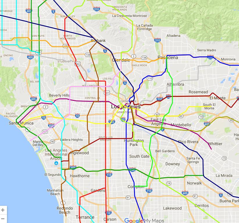
Evaluating Alon's plan: Considering that the Seattle metro area voted for a 35 billion dollar transit plan, mainly consiting of suburban light rail extensions (though there is also a new downtown subway thru Seattle), it’s not unreasonable to think that LA, with a metro population 4 or 5 times larger than that of Seattle, would vote for a 90 billion dollar system. Hopefully half the cost would be funded by the State and Federal government, with the local half covered by another 1/2 cent sales tax, plus a gas tax, motor vehicle licensing fee, and de-congestion charges on freeways and downtown LA, plus funded from the City of LA for a couple of the central-LA focused subways. If The Transit Coalition and Move LA sponsor the next ballot measure in 2020 or 2024, it could be passed with simple majority. The city of Los Angeles could also vote to support the system with extra funding, to help provide more service to the central city. I don’t entirely agree with Alon’s idea that every line needs to be fully grade-separated. The Metrolink lines and the some of the more suburban light rail lines could continue to have grade crossings, with quad-gates and preemption of cross-traffic; this may also be necessary to keep the cost within estimates. However, there could be a long-term plan to eliminate grade-crossings, and all new routes through the central city (405 to downtown, between of Expo and the hills) will need to be fully grade-separated, likely subways. I do think LA Metro needs to take a hard look a the greater Downtown Los Angeles area in the new Long Range Transportation Plan currently underway, and carefully consider future additional transit lines. The currently planned system (see map: ) will quickly put the Purple Line over capacity between Koreatown and Westwood and the Regional Connector will not allow frequent enough service for the Expo and Blue Lines (which will have to share tracks thru downtown). The 2009 long-range plan underserves central Los Angeles while requiring too many transfers at Union Station, especially if Metrolink is electrified and High Speed Rail reaches Union Station. Alon's idea of routing the Blue Line (or the Santa Ana Branch) straight north-west to Pershing Square and Bunker Hill is interesting. It might be easier than building a whole second Regional Connector subway to separate the Blue and Expo lines. But his multiple north-south lines in the San Fernando Valley are excessive; I don't see the need for all that branching. A second north-south line on Sepulveda would be great if the initial route reaches capacity, but keeping a grid structure in the Valley is better. It's also odd to have a Silver Line and Pink Line sharing Santa Monica Blvd through Hollywood. But most importantly, there is still no east-west line south of Santa Monica Blvd or north of Exposition, except for the Purple Line. Even with rerouting the Red Line south on Vermont, I think this will give insufficient capacity - especially since Alon is assuming that the Sepulveda Pass lines along 405 will need 4 tracks! We'll need another east-west line through central Los Angeles first. And as always, South LA seems to get left out. Alon does have an Atlantic line which helps serve Maywood, Bell and East Compton, but Southgate and South LA still have no rapid transit through their hearts, where there is high population density and lots of current bus riders. There's also no line serving the high density residential areas along in Inglewood and Hawthorne along Hawthorne Blvd, or along Anaheim and 7th St in Long Beach east of Downtown.  ![Alon Levy's Map]() |
|
|
|
Post by jeisenbe on Oct 24, 2017 19:07:21 GMT -8
My 4 Phase long-range plan for Los Angeles Metro / Metrolink transit: 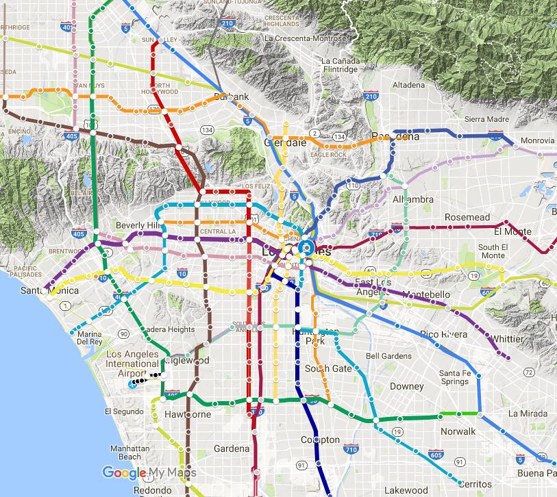 I made a new map that adopts a couple of ideas from Alon, especially the new north-south subway thru Downtown LA with transfers at Bunker Hill and Pershing Square, and a second north-south line for the Sepulveda pass. However, I reduced the number of north-south branches in the San Fernando Valley, and instead added more service to central Los Angeles. I have also selected the phases to keep new lines balanced in between different districts of the county; I believe this map has a better chance of passing the LA County supervisors and voters. The 4th phase adds even more transit, especially in central and SE LA, but would be over and above the level of Alon’s plan. (See a map of the 5 districts: egpnews.com/wp-content/uploads/2014/02/2Redist2011_BoardAdoptedPlan_LACounty-copy.jpg) Compared to Alon’s map, mine has more service in the densely-populated areas of central Los Angeles, and does not require as much new development or up-zoning to be feasible. However, it should allow the population of LA to increase by 50% over the next 35 years (a little over 1% a year), with the majority of new trips via transit (and most of the rest via walking and bikes), without new freeways. |
|
|
|
Post by culvercitylocke on Oct 24, 2017 19:35:46 GMT -8
the biggest problem with Alon's map is that he's only looking at Google maps and has never actually navigated these projected routes in person.
So, for example, you have the routing of his proposed sepulveda line. This line is routed, bizarrely, to the Expo/Venice station.
Also on the sepulveda line, for Alon, like all the crayon maps, persistsin sending criss crossing tunnels under the LAX runways. The FAA and LWA made it pretty clear that they are NOT allowing tunneling under the runways, ever. The connection point at LAX is always and forever going to be Aviation and 96th.
Due to living in the area around Howard Hughes center (as well as working in one of the office towers for a while), I can attest that putting a station at the 405/Sepulveda (or just to the east/west of the freeway) is a really bad idea. There are geographic constraints (that will complicate construction and significantly increase costs) to the road grades, and curve radii that will make subway construction especially difficult, and you have to realign the line to aviation and 96th, basically abandoing the sepulveda routing as soon as you cross the 405. Also, the Howard Hughes center is not worth serving with a stop, the office parks east of the fox hills mall are a source of much greater ridership (as is the fox hills mall). There is also ample possibilities for station box placement when you aim at splitting the difference between the mall and the office parks. This alignment also allows the route to tunnel under the 405 where it is berm supported rather than pylon supported, which means the tunnel does not have to be as deep. And this alignment also allows the route to align to aviation/96th more easily.
I am glad you mentioned South LA! Vermont is an excellent candidate for a rail line, I think the buses get like 60,000 boardings a day? right?
And the numerous crayon maps never put an east west line between Green and Expo, but Slauson is an excellent candidate for such a line.
and the numerous crayon maps never put a north south line east of the 110 freeway, we only ever see vaguely diagonal or east west lines that just serve the CBD. An eastern equivalent of the sepulveda line ought to be considered as well.
politically, Alon's suggestion of upzoning the foothill communities is adorable. remember it was La Canada residents who mobilized and fought for decades to cripple the freeway system by preventing the 710 from being built because they did not want semi trucks to use the 210 freeway.
The people of pasadena and south pasadena were not nearly as opposed as the millionaires of La Canada, mostly the locals were less opposed more divided than the la Canada opposition because the locals knew they would use the freeway and would thus gain from the additional connectivity it would have provided.
so Alon is really displaying the depths of his ignorance of the local situation to even suggest that we could just upzone the foothill communities when this particular community is the most dedicated, powerful and successful NIMBY community in all of los angeles
I actually think his two north south lines west of the 405 in the valley are reasonable, I think the sepulveda north south line is excessive, given Van Nuys is going to be the north south route of choice for transit.
Sending a line down montana in santa monica is profoundly ignorant, an example of overbuilding where there is no demand for transit and heavy opposition.
I also think the Lincoln Blvd corridor is ill suited for rail, I think Buses better serve this stretch.
A Venice line that serves La Cienega/Beverly Hills and West Hollywood before traveling to the CBD is a quite interesting possibility, and superior to a Crenshaw extension zig zagging over to Weho. however I think Santa Monica Blvd might well be impossible for an aligned Rail line if the Hollywood fault line lies underneath it (as geologists expect)
|
|
|
|
Post by jeisenbe on Oct 24, 2017 23:11:39 GMT -8
(BTW, I updated the picture of my map since your post, but the link is still correct) Agree, especially that the People Mover route is now decided. I believe Alon may have drawn this map a few years ago, before this was decided. I'm a little uncertain about what route you think is best for the Sepulveda/405 line thru Fox Hills. Do you have a map if this? East-west on Slauson and north-south east of downtown is "cross-town" service, rather than radial, so it will be lower ridership. But I do include a new line on Slauson in phase 3 from Atlantic to Crenshaw, and continuing southwest to LAX on previously constructed tracks. It makes a half-circle, following Atlantic to the north. In Alon's defense, his map also includes a map on Atlantic, so he does have cross-town service in the SGV to East LA and Compton. Yeah, I don't think that's very reasonable in the next 20 to 30 years. Perhaps in 50 years? It will be a very different community by then. Even in my phase 4, which has transit almost everywhere, I wouldn't put a line looping all the way northwest like that. There's just not enough flat land in that area to make a subway necessary, especially since he hasn't drawn a line for Western or Avalon or Long Beach Blvd. I believe this idea comes from the transportation engineer who writes at Let's Go LA, who should know better?: letsgola.wordpress.com/sepulveda-passlax-transit/I agree, for the next 30 years. BRT will be fine for Lincoln until everything else is built. The fault is along the part of Santa Monica Blvd through Century City and Beverly Hills, where it travels Southwest to Northeast, so it will probably be fine to have a subway (or elevated?!) along Santa Monica from West Hollywood and further east, as in the map. There's also a fault along the Sunset strip: yet another reason to avoid it for a station. 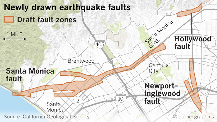 |
|
|
|
Post by culvercitylocke on Oct 25, 2017 2:02:58 GMT -8
I keep getting a "not found" on both the map and the link.
|
|
|
|
Post by culvercitylocke on Oct 25, 2017 2:20:19 GMT -8
What if we are all thinking about the Sepulveda line in the wrong way because we are all 405 dependent in our thinking.
In other words, we are always stuck in path dependency thinking. 405 path dependency thinking.
From Westwood to LAX, the sepulveda route hits no major job centers, since few jobs are situated adjacent to the 405. Even large employers like the Sony lot would entail routing through even lower density areas like cheviot hills.
And you then try to trade off with Howard Hughes or Fox Hills etc.
But what if the 405 didn't exist?
Then you would probably build an almost perfectly straight North-South Line from Aviation 96th up La Cienega, through the mountains under Laurel Canyon up Tujunga to the Sun Valley Metrolink Station.
This is a pretty damn good option, probably not being looked at because the we're trying to solve the 405 problem by staying 405 Adjacent.
just some random late night thinking outside the box.
|
|
|
|
Post by jeisenbe on Oct 25, 2017 5:50:09 GMT -8
[Which map and link are "not found"? Alon's (from the top post), or mine in the second post?] Well, the hills along La Cienega between Manchester and Expo are low (Ladera Heights) to no (Oil field / recreation area) density; there would probably be almost 3 miles without a station. Further north, La Cienega is a great option for a north-south line between Venice Blvd and Hollywood Blvd; I'd recommend that as part of the second phase after Measure M. But a tunnel through the hills straight north from La Cienega would end up in North Hollywood, just a mile west of the end of the red line. It would be an option to consider if the Red Line tunnels are going to reach capacity. But since we're already planning to build the Crenshaw line up to Hollywood and Highland, if we need a second tunnel it should probably be a continuation of the Crenshaw line to the north. And the line on La Cienega can turn east on Santa Monica Blvd (or Hollywood Blvd) instead. Also in favor of the Sepulveda/405 line is that UCLA/Westwood is a pretty good job center, Century City will be only 1 stop east, and Santa Monica will be a short trip west. Most people will need to transfer to get to destinations between Westwood and LAX, but that's the development pattern. 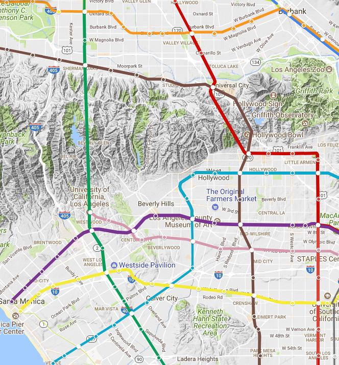 |
|
|
|
Post by culvercitylocke on Oct 25, 2017 12:07:46 GMT -8
It's really only a plausible thought experiment because of the access it gives to the two major hospitals it would include.
Also it is interesting to consider since it substantially shorter than the 45 km from sylmar to lax
In a way it is sort of a north south equivalent of the green line but without the interference of the freeway.
Yes the 3 miles between la brea and slauson stations would be rather glorious for moving people.
I was thinking of it more in terms of relieving the bottleneck created by the mountains between the valley and the basin by facilitating north south movement through eastern west la . What's interesting is that a la Cienega route relieves the bottleneck without mimicking an existing automobile route. How does that affect ridership, having an exclusive and superior transit route that can't be out done by a car?
I was sort of thinking the route would connect at the redline north Hollywood stop and the routes could interline from that stop to the metro link station, thus people would have The option of routing to downtown or routing to the hospitals/lax
|
|
|
|
Post by jeisenbe on Oct 25, 2017 16:09:07 GMT -8
But only moving them to Ladera Heights, LAX or the South Bay. And that 3 miles would cost $300 to $600 million with no additional riders. If instead the line on La Cienega turns southwest at Venice Blvd, it could serve central Culver City and Venice, while providing a transfer to the Sepulveda line for the minority of people going south to LAX or the South Bay. This route is only 2 miles longer but would have 3 additional stations. With a transfer, it would take 6 to 8 minutes longer (peak / off peak) for people to get from La Cienega to LAX / South Bay verses a direct line, but there would be twice at least as many destinations along the way.
I think people tend to overestimate the importance of direct trips to the airport, compared to other destinations.
This would limit frequency and reliability, and would require HRT technology (third-rail instead of overhead wires). If we're building a third tunnel across the mountains (after the Red line and Sepulveda Pass lines), we'll be doing it to maximize capacity on the new line. So long trains will be needed; maybe HRT is fine, but LRT is fine too if the platforms are long enough.
|
|

