|
|
Post by JerardWright on Oct 20, 2008 17:57:16 GMT -8
Let me ask a simple question, How many single level underground wyes that operates in 6 directions have been built by transit agencies around the world? * The Chicago L operates as a grade separated wye around Tower 12 at Wabash/Van Buren but that's on an elevated structure. From www.chicago-l.org * Another one close to home is on the Blue Line rail yard between Del Amo and Wardlow Station that's a 6 way elevated wye. However, I couldn't think of any underground that operate like this in such a tight setting. I started looking at BART, NYC Subway, DC Metro Boston Green Line, Our own Red/Purple Line at Wilshire/Vermont should have been set-up this way but it wasn't, they use flying junctions which are done in two levels. The closest to this is in Philadelphia around the 30th Street Station but this is a mix of at-grade and underground and it needs a lot of space in which to work with. Then I looked away from the US and looked at the German LRT/U-Bahn systems from which our own Regional Connector can learn from with multiple LRT lines running through a dense common trunk structure in their CBD and I didn't see not one underground single level wye that operates in 6 directions. It might have something to do with visability. Visability to the point that it will require a two level wye underground. So prepare yourself for that possible answer. It's not going to stop us as a group to propose a number of solutions including this one in our letter about 1st/Alameda crossing for the EIR so that Metro answers them. ======================================= BTW, The FTA cost-effectiveness that $18 Medium figure is based on; Blue Line to Long BeachGold Line to Sierra Madre Villa
Gold Line to Atlantic/PomonaExpo Line to Culver City(if it went to Santa Monica, that $18 figure would be a lower) How hard would it be to close off 1st Street at Alameda and divert traffic to Temple and 2nd Street? We'll need to do this in order to build any below-grade solution. How does that make a difference, if the frequencies are the same? The core tunnel in which it is running in is in a very dense and active environment. Which is why that artery is below grade. Look at that image carefully. The total at-grade solution is unacceptable because of the tight turns and curves. Is Alternative #5 perfect? No, however neither are any of the proposed solutions I see thus far. They all need work which is why much like Alt#5 will need fine tuning before presenting to the Project team. If we suggest an underground solution that is infeasible or unachevible then there goes any opportunity to have that studied in the EIR. |
|
|
|
Post by damiengoodmon on Oct 20, 2008 20:05:51 GMT -8
Is the visibility for Metro's option really much better than if it were below grade?
I don't think anyone's proposing the WYE as tunnels but instead as an open structure that is underground.
In Metro's proposal there appear to be plenty of blind spots. For a train coming from east LA. There would be no visibility to the trains coming from 2nd St and very limited visibility from trains coming from Union Station after the Mangrove project is built.
And where did the FTA cost-effectiveness come from? Didn't know or think one was created for the Blue Line or Pasadena Gold Line given that those were locally funded projects.
|
|
|
|
Post by JerardWright on Oct 20, 2008 21:22:03 GMT -8
Is the visibility for Metro's option really much better than if it were below grade? Yes, and with the at-grade platforms double as a holding pen for trains to pass. An open structure that is underground? Do you mean an open SPAN struture? With that you would still have to cover Alameda Street so that those vehicles can still pass through, correct me if I'm wrong here? So semantically and physically this is still an underground single level wye that has trains coming in 6 directions. Trains from Union Station have a clear view of the East LA Trains and the portal. Trains from the portal because it's on a diagonal can see both East LA and Pasadena branches. East LA can see the portal and because of the distance between the curves as shown on the conceptual rendering both lines can see the train from Union Station. What is confusing the focus is that little piece of spinach they drew on the rendering for landscaping in the central section which given the structure design I don't see that even being built. There was a question that was asked by J. Russell Brown from DLANC and your Kool-Aid drinking pal Darrell regarding the ridership modeling and FTA new starts cost effectiveness. That figure comes from current cost of the project divided by the new ridership from the assumed operation of current or under construction lines (Blue, Gold, ELA, Expo to Culver City) that Dolores and Ann stated. Notice it doesn't show Expo to Santa Monica, maybe Metro is slowly learning their lesson on FTA ridership modeling. Who knows? (Shrugs shoulders) |
|
|
|
Post by metrocenter on Oct 20, 2008 21:54:58 GMT -8
I tend to agree with many on this forum, that this junction should be underground. In particular, I really like jejozwik's concept (pictured below), except that the second station should be under the block to the southwest of 1st/Alameda, as in damien's proposal. It seems to me that if this could be pulled off (a big question from an engineering standpoint), this would eliminate the need to discard the old station, which would remain for Pasadena-Eastside trains. 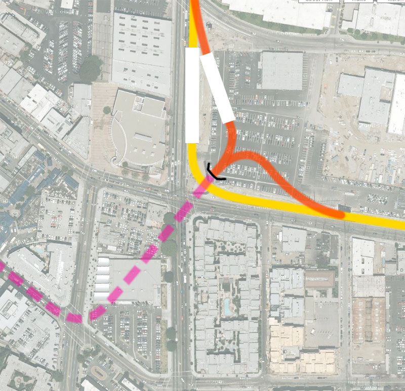 |
|
|
|
Post by Justin Walker on Oct 20, 2008 22:43:47 GMT -8
I also agree jejozwik's proposal makes the most sense. The new junction would be recessed and lead directly to the connector portal. But, Little Tokyo would be best served by a new underground station under 1st/Alameda. This would completely separate vehicular traffic from the LRT traffic. Pasadena-Eastside trains likely wouldn't be necessary because cross-platform transfers will be possible at the new underground station.
Similar versions of jejozwik's proposal appear to have been screened out since the last set of meetings (Alternatives 6 and 8) in favor of the current Metro-favored underground alternative with the at-grade junction (Alternative 5). It seems they did this so as to not interfere with the "Mangrove Property Future Development" on the NE corner of 1st/Alameda. If that is the reason, it is very short-sighted considering it would shortchange the functionality of the entire LRT network.
|
|
|
|
Post by JerardWright on Oct 20, 2008 23:14:00 GMT -8
The development is part of it but the other issue was Alt. 6 and 8 eliminated any potential for a Pasadena-East LA route option which Union Station stakeholders wanted to include.
Visually this looks great and the transition to Temple/Alameda with a small adjustment can work, however the big if on this proposal on the Eastside are;
* The length the trains have to transition from street level to underground, that curve in the portal midway isn't impossible but can it fit on the current constrained site?
* How the 1st Street drivers will have to react on very short spacing apart two different train movements. Eastside from Union Station and Eastside to Downtown. At least the at-grade wye there was only one spot in which to deal with this now we've created two. (Alameda and Hewitt/Garey)
|
|
|
|
Post by metrocenter on Oct 21, 2008 7:51:56 GMT -8
The development is part of it but the other issue was Alt. 6 and 8 eliminated any potential for a Pasadena-East LA route option which Union Station stakeholders wanted to include. The proposal by jejozwik doesn't eliminate the existing at-grade station on the Pasadena-Eastside route. I would think the biggest issue is the use of the land that is slated for development. The MTA would have to buy that: it could be very expensive. The other issue would be whether or not it's possible, given the need to incorporate tight descending S-curves. |
|
|
|
Post by darrell on Oct 21, 2008 9:01:04 GMT -8
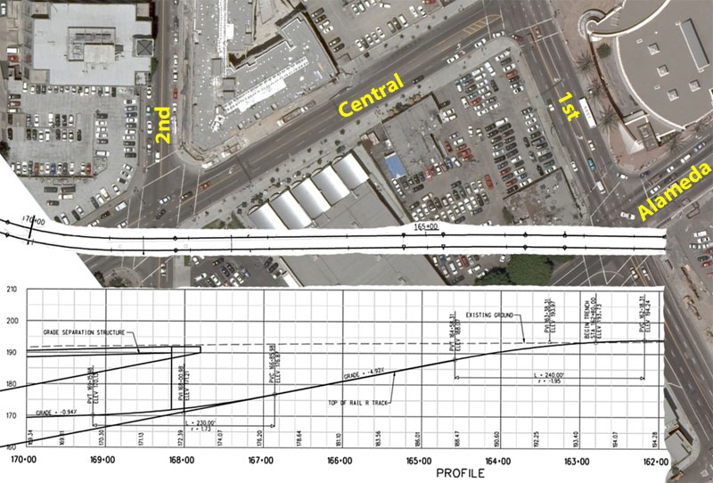 Thinking about the ramps that would have to fit within the blocks at 1st and Alameda led me to this. First, above, is the Expo Line ramp on Flower north of Exposition, scaled to the MS Live photo map, superimposed on the current subway option that puts a ramp between 1st & Alameda and 2nd & Central. Keeping the grade at about 5% but letting it continue deeper (which the Connector will do), allowed the portal to shift around 40 feet right, shortening the necessary open-air ramp length. It just barely fits on the diagonal across that block! It will obviously also need to begin a much tighter curve than the gentle Expo curve, in order to go under 2nd. 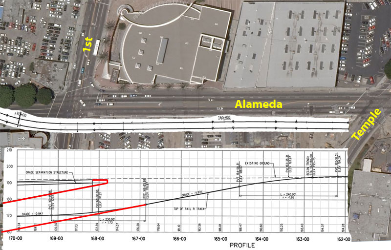 Here's the same plan and profile where a ramp would have to descend along Alameda between Temple and 1st if the tracks are to be under 1st & Alameda. Again, it appears to just barely fit. But things get more complicated with the track junction that would be under 1st & Alameda. I presume the engineers wouldn't want to put turnouts (switches) and crossings on a 5% grade; therefore the junction would have to be farther west after the tracks level out in the tunnel. And it appears the Gold Line connection between Union Station and 1st Street could not be done in the trench, as its turnouts and crossings would have to occur on the 5% grade. Perhaps on an at-grade diagonal across the block? You could request this be studied as an option in the Draft EIS/EIR, where the engineers could design the actual vertical and horizontal curves that would be necessary. Which would also give a more definitive comparison of its additional cost, travel time difference, and comparative traffic impacts. Different subject: Go see the historic map exhibit at the Downtown Library. It's maps of the original Los Angeles streets give a perspective on how this crazy street grid came to be. |
|
|
|
Post by jejozwik on Oct 21, 2008 10:58:05 GMT -8
where exactly does the caltrans bridge meet the grade downtown?
|
|
|
|
Post by jejozwik on Oct 21, 2008 11:28:53 GMT -8
version 2. continue the subway running until temple street. were the line would curve east to start the subway to surface ramp. turning south on vignes street, with a possible street closure, to connect with the existing line. 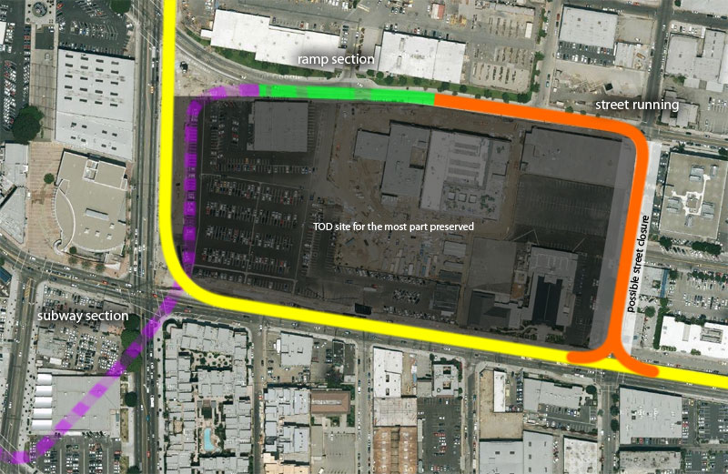 |
|
|
|
Post by jejozwik on Oct 21, 2008 11:35:41 GMT -8
i almost responded saying to do this with 2nd street then running north on vignes... but then the at grade intersection would show up again...
|
|
|
|
Post by metrocenter on Oct 21, 2008 12:51:50 GMT -8
My version of this would require purchase of the property: 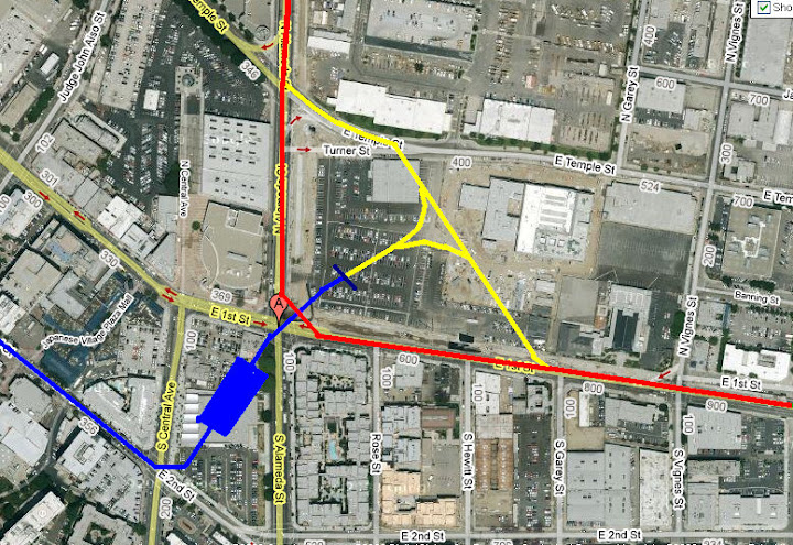 |
|
|
|
Post by JerardWright on Oct 21, 2008 12:56:24 GMT -8
where exactly does the caltrans bridge meet the grade downtown? To answer the question, Temple/Alameda. With Version 2, I wonder where the loading ramps will be located for the development? We've kept the large development in, now we need to find a spot to access it. I suppose they can enter on 1st Street. I also wonder how Version 2 affects that new Fire Department Center (the under construction building that is shown) that is across the street from DWP on Temple. As much as I would enjoy the 360 degree loop around the site as a transit rider to transition from underground to grade level, I don't know how they will be able to access their facility. Maybe the key ask that we want is a Grade Separated crossing. Doesn't have to be underground, it just need to be grade separated. I enjoy the ideas that are being stimulated and suggested, but coming from my professional background, I always know that with every new solution comes a different set of problems that need to be worked out. How we can work these things out will require key pieces of information. The pieces of info we need to know are:* How big is this Mangrove Site? * What are it's dimensions? * What buildings are adjacent to or abutting this lot? * What are the conditions of the adjacent and abutted buildings? * What is the maximum grade our LRV's can climb horizontally and vertically? * How much in linear feet does it take for an LRV to climb from below grade to at-grade? (Thank you Darrell with your post on the engineer profile of a below grade to street level transition ramp for a train) |
|
|
|
Post by metrocenter on Oct 21, 2008 13:39:04 GMT -8
New solution: raise both existing branches to an elevated wye above First/Alameda. Then, the trains would head southwest to a station equipped with train elevators that bring the trains underground.  Seriously though, I still (after all these years) insist that the easiest solution would be to wye at Temple/Alameda.  |
|
|
|
Post by jejozwik on Oct 21, 2008 13:47:31 GMT -8
With Version 2, I wonder where the loading ramps will be located for the development? We've kept the large development in, now we need to find a spot to access it. I suppose they can enter on 1st Street. I also wonder how Version 2 affects that new Fire Department Center (the under construction building that is shown) that is across the street from DWP on Temple. As much as I would enjoy the 360 degree loop around the site as a transit rider to transition from underground to grade level, I don't know how they will be able to access their facility. its a TOD, no need for entrance drives ;D. this was not a be all end all idea. just tossing the concept out. the ramp could be shifter more to the east until inches before the curve south. as far as the fire department center. im not sure how that is incorporated to the TOD development. my assumption was it would be razed and incorporated into the TOD plan. |
|
|
|
Post by JerardWright on Oct 21, 2008 13:52:52 GMT -8
^ I would love a TOD with zero Parking! ;D
However, we do need a entrance for the trucks to make their deliveries and load their goods to the development and if it's housing, a spot in which new residents can move in and load their furnishings.
Unless we can take a page from our friends on Wilshire between Westwood and Beverly Hills with their high-rises with no loading zones into their property and how much traffic that causes.
As for the Fire Center, that is under construction and it's a LA City Public Works project. IOW, that's a non starter to tear down a brand new building unless we want to pay $220 M for it so they can build a new one.
|
|
|
|
Post by jejozwik on Oct 21, 2008 13:57:25 GMT -8
who is going to tonights meeting? i will be unable to make it [11 hour shifts 8-8]
i really hope someone could attend and bring up the concerns made in this thread. we only have two meetings here, last chance till EIR-EIS is tonight
|
|
|
|
Post by Gokhan on Oct 21, 2008 13:58:19 GMT -8
I believe the Downtown Connector is going to being built cut and cover just below the surface, but correct me if I am wrong.
The maximum allowable grade is 5.00% = 0.0500. You can't have higher grade than that because otherwise the trains wouldn't be ADA-compliant and they might run into mechanical difficulties as well.
So, it's not difficult to calculate the required lengths for grade change:
15 ft --> 15/0.05 = 300 ft
20 ft --> 20/0.05 = 400 ft
25 ft --> 25/0.05 = 500 ft
30 ft --> 30/0.05 = 600 ft
Also, one needs to add an extra 100 ft or so to these numbers to account for smooth grade change from 5.00% to 0.00%.
Note that LRVs have a height of 12.25 ft, but you need to add the height of the pantograph to that and the thickness of the road-supporting structure above the trench.
So, it looks like you need about 500 ft to come at-grade. Then there seems to be barely enough space in the southwest block of 1st and Alameda for the current plan. The full subway, going below grade Alameda/1st would be easier to build than the current plan, since you have 600 ft to come at-grade at Temple north of 1st St. All the switches could be located on level track.
Regarding the concerns about rail - rail crossings, there will only be a single rail - rail crossing that will be frequently used -- between a northbound and a westbound train. The other two rail - rail crossings will almost be never used since they are part of the Gold Line - Eastside Line route, which may never be operated once the connector is in place.
|
|
|
|
Post by jejozwik on Oct 21, 2008 14:04:08 GMT -8
^ I would love a TOD with zero Parking! ;D IOW, that's a non starter to tear down a brand new building unless we want to pay $220 M for it so they can build a new one. never said crush the building to make the regional connector. i said i was assuming that with the TOD that all the buildings in the block would be part of the lot. anyhow, like i said in the last post, the ramp could be moved more east to allow for half of temple to be used for parking/receiving |
|
|
|
Post by JerardWright on Oct 21, 2008 14:21:35 GMT -8
Gokhan, Check your measurement of the distance between Temple to 1st Street. On my scaled maps I only have 400' which would not be enough space. Where as the SW 1st/Alameda diagonal I have it at 450' but it gains the extra transitional space by going 'at-grade' at 1st/Alameda.
|
|
|
|
Post by jejozwik on Oct 21, 2008 14:36:26 GMT -8
anyone interested in measuring distance, zmaps is a great tool |
|
|
|
Post by Gokhan on Oct 21, 2008 15:33:23 GMT -8
Gokhan, Check your measurement of the distance between Temple to 1st Street. On my scaled maps I only have 400' which would not be enough space. Where as the SW 1st/Alameda diagonal I have it at 450' but it gains the extra transitional space by going 'at-grade' at 1st/Alameda. I did and I was right. You have 600 ft between 1st and Temple and 500 ft on the diagonal of the southwestern block.   Although, I had ignored the small triangle in the parcel maps at Alameda/Temple. If you don't, you have 500 ft. The easiest way to measure the distances is Google Earth. It's pretty darn accurate. The most accurate and failsafe way is ZIMAS for City of LA. You don't gain additional distance by reaching a street. The top of the tracks need to be at grade level when you reach the street; otherwise, you can't run traffic through it. |
|
|
|
Post by Gokhan on Oct 21, 2008 18:05:01 GMT -8
I'm redrawing my proposal, this time more clearly and to scale. Light blue rectangle is the 400-ft-long station platform in a level open cut. Maroon, unfilled rectangles are open cuts. Maroon, shaded rectangle is a deck over the cuts so that the cars can run on it. The tracks below it are level; therefore, all the wyes are on level track. Note that there is only a single rail - rail crossing -- between the northbound and westbound trains. Further north the tracks become at-grade as they cross Temple and further east they also become at-grade in the median of the 1st street, in both cases the edge of the maroon rectangles represent the end of the retaining walls. Note that you need 500 - 600 ft for the tracks to come at-grade. There is sufficient space between Temple and 1st. The tracks would be approximately 22 ft below ground if designed smartly. That should be the track depth under the street deck at 1st and Alameda. I didn't include a Gold Line - Eastside Line wye, as I don't expect this to be used, but it could easily be included if necessary under the 1st and Alameda street deck. During the construction they could build a temporary at-grade Gold Line - Eastside Line connector and station in the northeast block of Alameda and 1st. 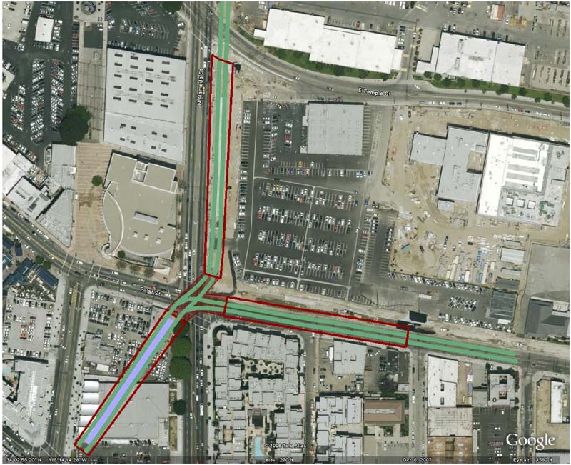 |
|
|
|
Post by darrell on Oct 21, 2008 19:01:38 GMT -8
I believe the Downtown Connector is going to being built cut and cover just below the surface, but correct me if I am wrong. They said deep bored tunnel at last week's meeting. The subway stations have mezzanines. I even heard that the current plan is to dive under the Red Line below Hill Street, but wonder if there is space above that tunnel. The maximum allowable grade is 5.00% = 0.0500. You can't have higher grade than that because otherwise the trains wouldn't be ADA-compliant and they might run into mechanical difficulties as well. So, it's not difficult to calculate the required lengths for grade change: 15 ft --> 15/0.05 = 300 ft 20 ft --> 20/0.05 = 400 ft 25 ft --> 25/0.05 = 500 ft 30 ft --> 30/0.05 = 600 ft Also, one needs to add an extra 100 ft or so to these numbers to account for smooth grade change from 5.00% to 0.00%. Note that LRVs have a height of 12.25 ft, but you need to add the height of the pantograph to that and the thickness of the road-supporting structure above the trench. So, it looks like you need about 500 ft to come at-grade. A little more, actually, probably at least 550 feet. The Expo Line on Flower needs about 600 feet from the beginning of the vertical curve to the portal (below; the heavy vertical lines are 100 feet apart, e.g. "167+00" marks 16,700 feet). It appears that could be reduced by some 40 feet if the ramp continues deeper (the straight lines I added, newly colored red) rather than transition back to horizontal. Then there seems to be barely enough space in the southwest block of 1st and Alameda for the current plan. Yes. The full subway, going below grade Alameda/1st would be easier to build than the current plan, since you have 600 ft to come at-grade at Temple north of 1st St. All the switches could be located on level track. Not so sure when the track will level out, or whether that's soon enough for the switches and crossing. Agreeing with your latest map, Gokhan, there would not be space for a Gold Line connector (Union Station to Eastside). Two considerations on metrocenter's and jejozwik's maps (previous page) are fit and running time. A straight ramp like above is about all that could fit northeast of 1st & Alameda. No platform, no switches, no tight reverse curves. The main issue that putting the tracks below 1st & Alameda would address is trains having to wait at an at-grade signalized intersection there, a delay of less than a minute. Substituting jejozwik's track around three sides of the block appears to add two tight curves and more running time. And metrocenter's at-grade wye at Temple & Alameda appears to substitute one at-grade wye for another and add more track length and curves. |
|
|
|
Post by metrocenter on Oct 21, 2008 19:17:07 GMT -8
^ I'll buy that.
|
|
|
|
Post by JerardWright on Oct 21, 2008 20:27:30 GMT -8
I like Gokhan's map now because it understands and realizes you can't do everything underground and at one point. In a subtle bit of irony you've recreated portions of Alternative #8 for discussion.
A few other needed adjustments/questions on your scaled drawing.
* For this, show how much space at NE 1st/Alameda we'll have between the edge of the sidewalk to the start Temple-First portal, this is the point where the train first starts in the portal heading north. That's important to show how much of the key corner space can be exposed to the developer for the entrance of his property so that a development could still occur even with the at-grade platform slicing through the lot.
* At the Temple/Alameda corner for the inclusion of the at-grade Pasadena Gold Line will there be enough space for a flat junction to occur? I think there would be but I don't know what angle the track is coming from and how fast a speed can be acheived.
|
|
|
|
Post by darrell on Oct 21, 2008 23:07:46 GMT -8
The current (October '08) Metro presentation (6 MB pdf) is finally available for download. |
|
|
|
Post by metrocenter on Oct 22, 2008 13:51:11 GMT -8
I think Gokhan's proposed route is very well thought out. And yes, it is essentially Alternative 8.
Unfortunately, it seems that Alternative 8 has been removed from consideration, because it would require demolition of the Little Tokyo platform. Did anyone who attended the meeting(s) get a feel for how flexible Metro might be on reconsidering this alternative?
|
|
|
|
Post by JerardWright on Oct 22, 2008 20:22:34 GMT -8
Well we can always suggest to study Alternative #8 as a comparative basis as Darrell suggested to Alternative #5 to help shape and refine the conceptual engineering needed in the EIR. Thus far through this phase of the project I think they've listenend to the Downtown Stakeholders coupled with the systemwide importance of it, I think they will listen.
That is why in my posts I asked the questions in such a manner that we can suggest the questions as to the why this works better or why does this is easier to do than the other one alternative. Rather than carry-on in a knee jerk uncontrolled fashion that we want underground and that's it. We have to relate to what the concern was and answer that question as well as query the how's and why's,
You know a dialogue.
At the first or second phase of the Alternatives Analysis (AA), Alt 6 and 8 were eliminated due to the development and lack of Pasadena-Eastside connection. For this, we must modify the idea as to show why it could work and then sell how that can be done. Because we recognize one of the parameters and found a potential solution(s) that fits those parameters. That is why I asked, "Where is the delivery lane/loading area going to come into the site?" Why, because that is the first thing a developer will want to know. If it's feasible to do that because now that one little function will effect the size, shape and scale of the development. If the developer can only acheive a small entrance or none at all, that constrains how much and how well an ROI s/he will get for the investment. Eat up too much space with the tunnel structure that limits how tall and what kind of development goes on the site because that affects the type of foundation needed for the structure.
Why are all these things important because, we are about to enter EIR phase and the more questions related to this and the more analysis required to compare and contrast, the more they need to do the conceptual engineering to answer those questions to make a better project.
|
|
|
|
Post by metrocenter on Oct 24, 2008 6:17:19 GMT -8
^ You're absolutely right. It's easy to slip back into the mode of "the correct answer is obvious: if you don't get it that's due to your ignorance". That mode may work on the forum, but it'll get you nowhere in the real world.
There's also the matter of keeping perspective. For example, while we're debating how best to send the train underground, the MTA is still considering an at-grade alternative. While it's clear to us that underground operations make the most sense, that decision has not yet made. Therefore, this issue must be the number-one priority for lobbying efforts and transit advocacy.
|
|


