|
|
Post by Jason Saunders on Feb 13, 2009 9:20:18 GMT -8
I received the below e-mail from the Los Angeles County Bicycle Coalition yesterday. I wonder if any of you can shed light on why the bike lanes are being left out of the DEIR and what the plans are for a bikeway?
______________
Begin Email:
ACTION ITEM: EXPO BIKEWAY IN TROUBLE
Background:
A new light rail line, called the Expo Line, will eventually extend from downtown to Santa Monica. The project is divided into two phases. Phase I is under construction and will end at Robertson & Venice in Culver City. Phase II will extend the line from there to Santa Monica. Phase II is still in planning phases, and a draft environmental impact report was released last week.
One of the things that has been promised for the Expo Line is a bikeway adjacent to the train line. This would create a continuous bikeway from Santa Monica to downtown if it were built!
Recently, the Expo Construction Authority decided NOT to include the bikeway in the environmental review for Expo Phase 2, to avoid the burden of doing a federal environmental impact statement. Thus, the bikeway segment of the plan will not be considered by Expo Construction Authority even though it has federal funding.
This has created serious uncertainties about how, when or if an Expo Bikeway will ever be built.
TAKE ACTION:
If we want the bikeway to be part of the Expo Line project, it is IMPERATIVE that our elected city officials hear our demands to build the bike path simultaneously with the rail line.
Please contact our representatives now and attend one of the upcoming hearings (dates and locations below).
Key points to make:
- The bikeway must be built simultaneously with the Expo project. If it is not included in the environmental review, we need a commitment and a plan from Expo on how that will happen.
- If the Expo Bikeway is not built at the same time as the rail line, costs will increase dramatically and construction difficulties could arise if light rail construction does not provide space for the bike path.
- The goal of the Expo project is to reduce auto use. The bikeway is a critical component for achieving this. It can deliver transit users to stations without car trips and provides a much-needed crosstown commuter bikeway.
- If Expo must forgo using federal money for the light rail component, they should also secure funding from other sources for the bikeway.
- The Expo Bikeway is a wonderful opportunity to expand our network of safe bike routes for a growing community of cyclists.
ATTEND A MEETING (see below) and speak in support of the Expo Bikeway!
Please WRITE or CALL no later than 5:00 pm on March 13, 2009 to ask for a bikeway to be included in Expo Line construction!
Contact info: Call, snail mail, and/or email your comments to:
The Expo Line DEIR is open for public comment online at:
http://www.buildexpo..org/phase2_overview.php or email <phase2@exporail.net>
|
|
|
|
Post by mattapoisett on Feb 13, 2009 12:38:30 GMT -8
I have read on Streetsblog LA that all of the money for the Phase 2 Bike-way would have come from the Feds. The money is there for the bike-way but it would require a Federal EIS. Since the rest of the project would be getting non Fed funds if they Eliminate the bike-way they eliminate the need for the FEIS and potentially Speed up the project.
There are other issues like the bike-way not fitting through the tunnel under the 10 and it would have to be redesigned around that.
Take Care
- P.
|
|
|
|
Post by Jason Saunders on Feb 13, 2009 14:29:12 GMT -8
Here is the text of the Streets Blog column: la.streetsblog.org/2009/02/12/fear-of-federal-oversight-imperils-expo-bikeway/#more-1748Last month when I first looked through the environmental documents for the proposed Phase II of the Expo Line, I was encouraged because the maps included with the Draft Environmental Impact Review required by clearly showed a completed bike trail connecting Santa Monica to Downtown Los Angeles. Appendix E of the DEIR actually includes a description of what facilities along the trail would look like. However, according to the Los Angeles County Bike Coalition, the bike trail portion of the proposed Expo Line is currently endangered by a decision by the Expo Construction Authority. In an email to supporters, the Bike Coalition asks members to contact the politicians that makeup the Expo Board to pressure them to include the bike path in its final plan. What's happened is that the Expo Construction Authority decided to refuse federal money for the project so that they can avoid going through the NEPA process or any other federal oversight. Unfortunately, the bike trail is completely funded by those federal dollars, so even though the money is available, the Expo Construction Authority isn't willing to do the work needed to procure those funds and build the bike trail. Expo's solution is that "others" should be responsible for completing the trail. Whoever these "others" are, Expo, Metro, Caltrans are all possibilities, they would be responsible for completing the federal environmental review. If Expo won't consider moving forward with the bikeway and the federal review on its own, it would be preferable if the "others" committed to the project before the current state mandated environmental review is completed. A complete copy of the bike coalition's action alert, including who to contact and how to comment, is available after the jump: |
|
|
|
Post by kenalpern on Feb 13, 2009 15:28:59 GMT -8
Methinks that the Bikeway money maybe shouldn't be built with federal dollars in this case, and that the bikeway should be in the plans and map for the Final EIR.
|
|
|
|
Post by Jason Saunders on Feb 13, 2009 16:21:35 GMT -8
Why do we need a federal environmental review for an urban bike path on city streets? Isn't it obvious that a bikepath is environmentally positive. Do you really need an environmental process to confirm this?
Second, why not just throw the bikeway into the EIR at least then the bulk of the environmental work will be done. I don't know how much more is is involved with an EIS but come on it's a urban bikepath.
Third, how much additional funding are we talking about here? The renderings I have seen all show the bikepath as being demarcated by a white paint stripe on existing roadway. Do they really mean to say there is enough funding to build the light rail with local funds but not the bikeway, not the white stripe?
Come on people..... think outside the box.
|
|
|
|
Post by warrenbowman on Feb 14, 2009 9:51:35 GMT -8
I haven't been active, on the board or at meetings, in a while. But I went to a *lot* of meetings when Expo was in it's infancy. One of the main reasons I supported the project was the bike way. In a city that has as poor a bike infrastructure as L.A., a bikeway from downtown to Santa Monica would be golden. Ken, or anyone, how do we make sure that this great opportunity does not get quietly missed?
|
|
|
|
Post by kenalpern on Feb 14, 2009 12:26:32 GMT -8
Make it clear at the upcoming Draft EIR meetings that you expect the Expo Construction Authority to not get out of its responsibility to establish this Bikeway. As far as I'm concerned, this Bikeway is as essential as the catenary wires are for this light rail project.
|
|
|
|
Post by Jason Saunders on Feb 14, 2009 19:18:01 GMT -8
I'm glad other people feel the same as I do. If anyone has more info please share it. I would like to know:
- How much more does the bikeway cost?
- if no bikeway was being built because of funding sources does that mean no bicycle amenities such as bike racks would be provided at stations?
- Does it cost more to break it up into two projects?
- Does any work have to be undone if the bikeyway is built latter?
- Are Federal dollars already allocated for the bikeway, or is just intended that "a agency" will go after them in the future?
- If local funds are used to build the bikeway could the allocated federal dollars be diverted elseware in Los Angeles for Bikeway/Sharrows improvements/infrastructure?, such as a sharrows on Venice Blvd between Crenshaw and downtown L.A. where Venice is too narrow?
-If the Expo Authority doesn't build the bikeway then who and when?
This light rail line should be an example to other cities of what can be done, not an example of what could have been done.
|
|
|
|
Post by darrell on Feb 14, 2009 23:11:42 GMT -8
Here's what I understand from conversations last week.
Metro has already allocated $5 million in federal funding to the cities of Los Angeles and Santa Monica, I think referring to plans before the light rail project got going, for east of the 405 and within Santa Monica. More money is needed for 405 to Centinela.
Because this federal funding is incompatible with the CEQA Draft EIR the bikeway environmental clearance and seeking more funding was transferred to the cities, apparently like was done for the Orange Line busway.
Expo says they have provided for the bikeway in their plans and will include it in the final design and construction contract to be built at the same time as the rail line.
We're generally relieved that the bikeway is still in the plans, but concerned that what Expo indicated in their plans is inadequate in certain areas (National to Overland, Sawtelle to Gateway, Stewart to 20th), and whether the cities will complete their work in time for construction. We'll do our best to help monitor and facilitate.
Comments on the DEIR in support of the bikeway should help.
|
|
|
|
Post by Gokhan on Feb 16, 2009 20:15:30 GMT -8
$5 million is such a small amount of money for this $1 billion project. Minor enhancements (such as tiles) to a station can cost that much. Therefore, I find it hard to believe that they would go for federal funding for only $5 million. So, it could be that they expect the cities to contribute much more than that, perhaps on the order of $10 - $40 million, allowing the bike overpasses at Pico/Sawtelle etc. to be built. Or, perhaps, they could allocate local money later on and forgo federal funding ($5 million). I know for example, they tried hard to get the money for the USC Station ($5 million as well) from USC until the last minute and then USC didn't give a dime (as expected for an institution that opposes the project); so, they ended up getting the funds from Metro. There might also be other strategies being played. I don't think they would really ignore the bike path, which is such an important part of the project, but it's still somewhat a shame that they are making it part of a strategy game, which is jeopardizing it. They could certainly have had local $5 million easily for the bike path.
But it's very important for everyone to comment on the bike path during the current DEIR period so that it's included as fully as possible in the project.
|
|
|
|
Post by darrell on Feb 16, 2009 20:32:08 GMT -8
The $5 million may be what was allocated a few years ago for Los Angeles west of I-405 and Santa Monica, even before light rail on Exposition was approved. That idea is reinforced by what I heard that Los Angeles will still need to find funding for the I-405 to Centinela section.
|
|
|
|
Post by Jason Saunders on Feb 17, 2009 20:00:22 GMT -8
Sorry Darrell, I'm trying to understand what is funded and what is not but I'm not following you.
"5 million For L.A. west of 405 and Santa Monica" I assume you mean between 405 and S.M. and that the this 5 million is not adequate for this one mile segment
At this stage is that all that is funded/appropriated for a bikeway for phase 2?
|
|
|
|
Post by darrell on Feb 17, 2009 22:58:04 GMT -8
"5 million For L.A. west of 405 and Santa Monica" I assume you mean between 405 and S.M. and that the this 5 million is not adequate for this one mile segment I think the bikeway sections west of Centinela in Santa Monica and east of I-405 in Los Angeles have funding (totaling $5 million), leaving the gap from I-405 to Centinela needing to find funding. |
|
|
|
Post by joshuanickel on May 21, 2009 16:56:20 GMT -8
|
|
|
|
Post by Jason Saunders on May 26, 2009 19:15:15 GMT -8
What do you guys think of this as a detour of the bike path around the 10 Freeway tunnel?  Virtues: - It keeps the bikepath continuous, - stays close to Expo, - reduces grade climb for cyclist. (Overland National are steep!) - Maintains class 1 (fully automobile separated) bike path along Expo trench after 10 FWY - Does not require expensive construction of tunnel or overpass. Ills: - It requires cutting a path out of the freeway embankment. The Freeway would be physically above the bike path which is good - Cyclist have to cross motor. May require signal - Cheviot Hill people may not be happy about having a bike path running behind their houses. |
|
|
|
Post by losangeles2319 on May 26, 2009 19:23:24 GMT -8
I think the NIMBY's in Cheviot Hills would be much less concerned with a bike path when a train will "soon" be traveling behind there homes.
then again...
People could easily get off their bikes if they wanted to cause mischief.
But really, whats the difference.
Couldn't people easily ride their bikes into the neighborhood if they really wanted to.
|
|
|
|
Post by darrell on May 26, 2009 22:30:13 GMT -8
- It requires cutting a path out of the freeway embankment. Actually, no, re: the freeway embankment. Better than that, the City of Los Angeles owns a conveniently-located sewer easement along the north side of the freeway that would be a great bikeway right-of-way. It's like an extension of Northvale Avenue to Motor. See where it says "Restricted Use Easement" on this parcel map detail from the County Assessor's Office? 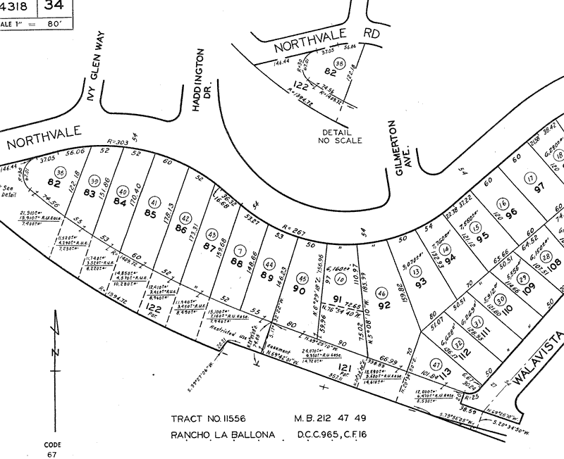 It is definitely a possibility. There have been conversations with the City, Metro, and Expo about it. Also with the adjacent property owners, although I've heard they're not so favorable. It's the bright green strip right of the freeway on this MS Live aerial map, looking west from Moter. 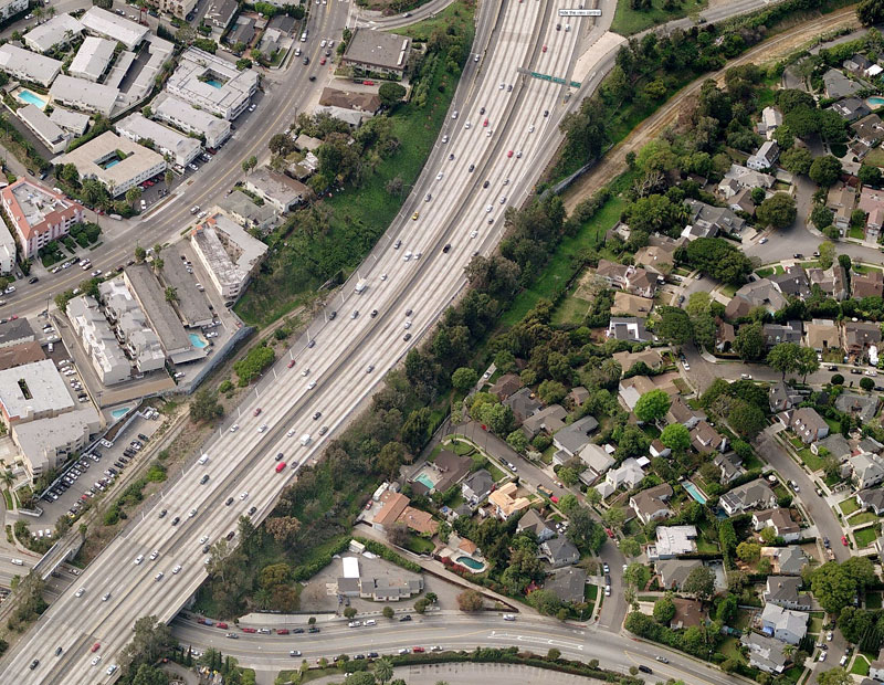 |
|
|
|
Post by Gokhan on May 26, 2009 23:09:10 GMT -8
Yep, this is the beautiful RUE (restricted-use easement) around the corner from where I live in Palms, a little jungle hidden in the city. Hopefully they leave most of the trees and green space when they pave for the recreational path.
There are apparently monarch butterflies that habitat this area. The Palms Stop was originally known as the Grasshopper Station, due to the clouds of grasshoppers in late 19th Century when these areas where all ranches. I saw one recently in that area. Despite all the urbanization, some species survive. The other know sensitive species were the raptors (hawks etc.) that nest on the trees. Because of that they couldn't remove or relocate the trees on the Expo right-of-way during their nesting period.
|
|
|
|
Post by Gokhan on May 27, 2009 14:45:21 GMT -8
The other species that habitat the Expo right-of-way are the stray cats, most of them black. They live in the vicinity of the Palms Park by the pedestrian overpass over the tracks there. At one point there were more than seven dozen of them but someone, probably a dog lover & cat resenter, had most of them trapped, and the last time I saw less than a dozen remaining. I once saw a guy with a fairly large dog heading to the pedestrian overpass to cross from Cheviot Hills to the Palms Park. The guy was literally dragging the dog through the leash, as the dog tried to brake against the pavement with its feet. At the same time, the dog was shivering. It was an incredibly funny sight. The guy finally gave up and picked up the large dog and carried it across the pedestrian overpass. The dog was apparently scared to death of the cats there. When they reached the Palms Park though, the dog was happily catching Frisbees.  |
|
|
|
Post by kenalpern on May 27, 2009 21:18:13 GMT -8
My son and his friends love playing with the cats when they play at Palms Park.
|
|
|
|
Post by Jason Saunders on May 27, 2009 22:03:50 GMT -8
I've seen these cats you guys speak of as well. Speaking of Palms Park, another benefit to a bike path at this location is that it opens up a new portal to Palms park for people who live south of the freeway.
I really think this is an excellent bike path connectivity solution and hope that it comes to fruition. I really can't see why these residents would be opposed to to a bike path here. The benefits far outweigh any negative consequences and it seems to me an amenity like a bike path only increases the value of a home.
|
|
|
|
Post by Gokhan on May 28, 2009 6:49:07 GMT -8
One other somewhat-unusual species living in that area are the coyotes that inhabit the Cheviot Hills and Rancho Park country clubs and golf courses. They apparently feed on golf-course rodents. One night I saw two of them prowling as far as near Ashby and Overland, just by the right-of-way. There were reported cases of cat remains at times; so, they must occasinoally be feeding on other small animals as well. Although they are harmless to humans, people are adviced to keep their small pets indoors to avoid them ending up as food for the coyotes.
|
|
|
|
Post by Gokhan on May 28, 2009 6:52:54 GMT -8
I've seen these cats you guys speak of as well. Speaking of Palms Park, another benefit to a bike path at this location is that it opens up a new portal to Palms park for people who live south of the freeway. I really think this is an excellent bike path connectivity solution and hope that it comes to fruition. I really can't see why these residents would be opposed to to a bike path here. The benefits far outweigh any negative consequences and it seems to me an amenity like a bike path only increases the value of a home. One thing that worries me is the proposed at-grade bike crossing at Motor Ave. They are diverting the bike path from the right-of-way to National starting around National/Palms and the bikes would have to cross Motor Ave to access the restricted-use easement by the north embankment of the freeway. In that area Motor is downhill with a curve, creating high speeds, low visibility, and difficult braking. So, I'm worried that some cyclists might easily get hit by cars there. |
|
|
|
Post by mattapoisett on May 29, 2009 11:00:01 GMT -8
FYI: the LA City Bicycle Plan Folks have released their preliminary Maps for the LA Plan. Including the Expo Bike path You can post comments to the committee through the site. www.labikeplan.org/ |
|
|
|
Post by Jason Saunders on Oct 14, 2010 8:27:21 GMT -8
I'm trying to picture how the Bikeway will cross La Cienega as it exits the area behind "The great wall of Culver City." Will it curve across the western station plaza? Will it proceed directly across La Cienega and then across the eastern Plaza? Will it go at an angle across La Cienega connecting with the Jefferson bike path? How will people traveling West on bicycle connect? I imagined the westbound bike lane to be on the North side of Jefferson. A tricky connection to the south side of the Great Wall of cc.
|
|
|
|
Post by jeisenbe on Jul 5, 2011 15:13:02 GMT -8
|
|
|
|
Post by Gokhan on Jul 5, 2011 18:04:44 GMT -8
Note that the bike path has stopped at Ballona Creek because Culver City is not paying Expo $4 + $3 = $7 million dollars they promised. LOL
|
|
|
|
Post by rajacobs on Sept 24, 2011 23:50:46 GMT -8
Since the last post, the bike path to the Culver City station is again under construction. Beyond North of Venice, it has been noted that the path continues along the northside of the ROW to Bagley, then crosses the tracks and continues along the southside of the ROW until Palms. Then it continues on National to Motor, then Motor until it reaches the ROW.
It occurred to me that a preferred route from Bagley, that will probably beat the congestion along National, is to turn right from Bagley and go under the freeway bridge, then left on Harlow (next to the freeway) through the Cheviot Hills Shopping Center at the end of the street, then straight up Manning to Motor, left on Motor (with a light) and back to the ROW.
The advantage is: 1) virtually no traffic on Harlow, 2) relatively light traffic on Manning. The only disadvantage is a small hill climb up Manning. The speed of cars around the curves on National bothers me, as does the requirement of crossing Motor mid-block to re-enter the bikepath west of Motor.
|
|
|
|
Post by Gokhan on Sept 25, 2011 9:36:00 GMT -8
We can't have a major bike path through the busy Vons parking lot, rajacobs. It would also have several street crossings, including two freeway ramps, two moderately steep uphills on Manning, and a long detour. I think National Blvd, once clearly striped for the bike lanes and sidewalks are constructed, won't be that bad. It's also an existing bike route and cyclists are familiar with it. But they have to put a really good bike crossing at Motor and I-10 north embankment (where the bike path will follow) though, as there is a blind curve there. |
|
|
|
Post by rajacobs on Sept 25, 2011 16:48:43 GMT -8
OK, ...granted, Von's parking lot is busy; nonetheless eay to ride through. And one freeway lamp is with a 4-way light. The other is only on the south side of the street, not affecting nw-bound cyclists. ...But I'll stand down this alternative.
As for National, loose the car parking on the north side of the street and I'll feel much more comfortable. As for clear striping making a positive impact on safety. ...Don't think so because the road is soooo curvy, apparently intended to accommodate the once and now forgotten Palms Depot (just my supposition). Now, it's hard in even normal driving, let alone fast driving, to stay to the right on the marked lanes. Add greater lane congestion, and there'll be accidents.
|
|