|
|
Post by tramfan on Oct 13, 2015 12:57:13 GMT -8
Lot more photos of the bike path on Expo line fan's Ipernity page: the most interesting one is the traffic light with a bicycle on it, a first in LA. In countries like the netherlands and Denmark these traffic lights for bicycles only are very common.
|
|
|
|
Post by bzcat on Jan 8, 2016 11:48:29 GMT -8
|
|
|
|
Post by tramfan on Jan 8, 2016 15:43:47 GMT -8
This is an important meeting! I've ridden the Expo bike path many times with my road bike and although I like to climb the current Northvale route from Overland to Motor has some challenging hills that will not be easy to scale with a street bike. Another challenging part of this bike path is the crossing at Pico/Westgate. When the planners showed it to me at a meeting I already told them that this was ludicrous; coming East from Sawtelle you have to cross Westgate and then North to cross Pico to the bike path, going East you have to do the same thing in opposite direction; two busy streets with long waiting times for the traffic lights for pedestrians/cyclists. As cyclists always take the route of least resistance they will cross Pico directly: a very dangerous undertaking but it is what I do when I use the bike path going East. A solution would be what they built under the Olympic Expo bridge a traffic light for cars to let bicycles cross Olympic: a first in LA. Going West on the bike path I ignore the bike path from Sawtelle to Pico and just make a left turn at the light at the Pico/Sawtelle intersection. Other then those two issues this is a very nice bike path that is being used by many cyclists already even though the official opening is still months away.
|
|
f ron
Full Member

Posts: 222
|
Post by f ron on Jan 9, 2016 12:57:26 GMT -8
This is an important meeting! I've ridden the Expo bike path many times with my road bike and although I like to climb the current Northvale route from Overland to Motor has some challenging hills that will not be easy to scale with a street bike. Another challenging part of this bike path is the crossing at Pico/Westgate. When the planners showed it to me at a meeting I already told them that this was ludicrous; coming East from Sawtelle you have to cross Westgate and then North to cross Pico to the bike path, going East you have to do the same thing in opposite direction; two busy streets with long waiting times for the traffic lights for pedestrians/cyclists. As cyclists always take the route of least resistance they will cross Pico directly: a very dangerous undertaking but it is what I do when I use the bike path going East. A solution would be what they built under the Olympic Expo bridge a traffic light for cars to let bicycles cross Olympic: a first in LA. Going West on the bike path I ignore the bike path from Sawtelle to Pico and just make a left turn at the light at the Pico/Sawtelle intersection. Other then those two issues this is a very nice bike path that is being used by many cyclists already even though the official opening is still months away. I use the bike path frequently and I agree with both the points you're making. The Pico/Gateway crossing is messed up no matter which route one takes. Whether it's your preferred shortcut on the officially sanctioned route, bike traffic spends too much distance sharing sidewalk with pedestrians --around bus stops even!-- and it's only a matter of time before a bunch of people get seriously injured. A dedicated light could circumvent some of it but I fear the wait times there would be even longer than what's at the official crossing. I'm mighty interested to see what comes of the Northvale component. My only concern there --other than the when (bet you it takes much, much longer than they're going to say) is how many more trees will be felled along the trench to build it. Other than that, it's a fantastic amenity. The section between Overland and Military is especially nice and it's always in use by locals of all ages! |
|
|
|
Post by darrell on Jan 15, 2016 12:45:18 GMT -8
Here are photos from Wednesday's well-attended Overland-Motor bikeway meeting of the two main boards: 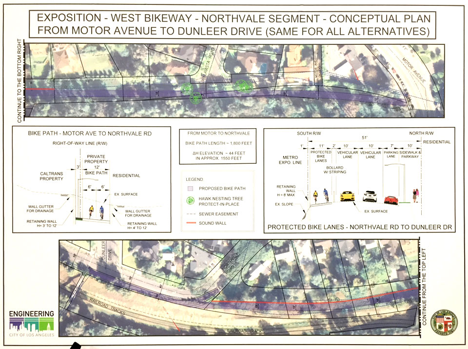 This shows the path along the City-owned easement from Northvale to Motor between back fences and the freeway embankment. Because of the 44-foot elevation drop toward Motor much of this route will be between retaining walls to ease the grade. 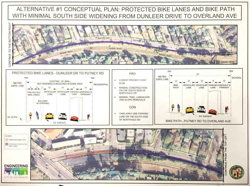 Three alternatives along the Northvale section were described: 1. Bollard-separated bike lanes along the current south side of Northvale, as shown in this board, with a little narrowing of the traffic lanes and loss of parking on the south side; 2. Widening of Northvale to provide wider lanes, that would cost more and lose much of the existing vegetation; 3. Bike path in the trench with big retaining walls. Good news is that Councilman Koretz and City engineering staff are working on finally moving this forward, and the Northvale option 1 along with the previously-controversial easement section farther east seem to be the consensus to move forward. They do need a little more money to build it. Also see Streetsblog's post about the meeting. |
|
|
|
Post by Gokhan on Jan 15, 2016 16:35:43 GMT -8
It's good that they are protecting the hawk nests. Will they eventually cut those trees after the baby hawks leave or keep them permanently?
I like Alternative 1. It's minimally invasive, other than some vegetation and habitat loss on the restricted-use easement.
Sound walls for the bike path??? What is next? Sound walls for sidewalks?
|
|
|
|
Post by thanks4goingmetro on Feb 9, 2016 15:57:22 GMT -8
 Went for a bike ride from Culver City to Marina Del Ray and I used a portion of the finished Expo bike way from Culver City Station to Palms station where the sidewalk peters out—I wasn't alone either, the locals are walking and biking it too. Can't wait for it to go all the way through.  |
|
|
|
Post by tramfan on Feb 10, 2016 15:05:29 GMT -8
I've been using the bike path from Pico to Bundy at least 3 times a week both ways and from Santa Monica to Military once a week. For some reason some parts that are ready to use are still closed of with fences but the ones without are used frequently by cyclists. From 17th Street to 26th Street is barricaded with fences, from 26th to Centinela is unofficially open and great to avoid heavy traffic on Olympic, from Centinela to Westwood is open with some obstacles under 405 under crossing where homeless people have set up camp with three large tents and lots of junk. From Westwood to Overland is ready for use but also fenced off. From Palms to Venice is open with some fences that are easily to ride around. The Military to Westwood section is used by locals very frequently with kids on skateboards and scooters, dog walking and of course cycling. All traffic lights work for cyclist to cross the intersections safely. When officially opened it's going to be used very heavily I expect.
|
|
f ron
Full Member
Posts: 222
|
Post by f ron on Feb 10, 2016 16:09:31 GMT -8
It's pretty great. I expect I'll be using it more more than the train --and depending on how far one is traveling point to point it could well be faster. It could be a hugely popular feature so long as the path is maintained and understood to be safe.
In addition to the burgeoning homeless encampment beneath the 405 --sofas and tents on the bike path, really?!-- the often closed but sometimes open segment between Centinela and Stewart also seems to be a favored spot for the homeless. Unlike beneath the 405 where at least the wary rider can go around those people--some of which are vocally agitated and hostile, note the copious broken bottle glass littering the path behind the liquor store between Sawtelle and Pico-- the section west of Centinela is enclosed on two sides. It could potentially be a concern for someone riding alone at night. Given the number of encampments around the I-10 area I gotta wonder how this sort of thing is going to play out on the yet-to-be-built trench portion of the path which promises to be even more remote.
|
|
|
|
Post by tramfan on Feb 11, 2016 13:50:43 GMT -8
The more cyclist are using the bike path the less it becomes attractive for the homeless. I'm sure that before the official opening the LAPD or the Sherriffs office will do a clean sweep of the bike path and remove the homeless.
The section South of Pico to Sawtele is a total disaster because it does not go anywhere apart from all the broken bottles and garbage littering the path. It's safer to take Pico or Exposition West of Sawtele even if you have to deal with more traffic.
|
|
|
|
Post by tramfan on Feb 16, 2016 11:50:44 GMT -8
I rode the bike path from Santa MOnica 17th Street to Military: all construction fences were removed. There were a lot of bicyclists using it already.
|
|
|
|
Post by joshuanickel on Mar 31, 2016 17:40:38 GMT -8
Here are photos from Wednesday's well-attended Overland-Motor bikeway meeting of the two main boards: This shows the path along the City-owned easement from Northvale to Motor between back fences and the freeway embankment. Because of the 44-foot elevation drop toward Motor much of this route will be between retaining walls to ease the grade. Three alternatives along the Northvale section were described: 1. Bollard-separated bike lanes along the current south side of Northvale, as shown in this board, with a little narrowing of the traffic lanes and loss of parking on the south side; 2. Widening of Northvale to provide wider lanes, that would cost more and lose much of the existing vegetation; 3. Bike path in the trench with big retaining walls. Good news is that Councilman Koretz and City engineering staff are working on finally moving this forward, and the Northvale option 1 along with the previously-controversial easement section farther east seem to be the consensus to move forward. They do need a little more money to build it. Also see Streetsblog's post about the meeting. LADOT has announced on their website that they will be moving forward with option 1: LADOT - Closing the Northvale Gap within Expo Bike Path |
|
|
|
Post by Gokhan on May 5, 2016 13:23:07 GMT -8
Class 2 bike lanes have appeared on National Blvd between Palms/Exposition Boulevards and Motor Avenue. This has eliminated the center lane and the no. 2 lane just east of Motor Avenue.  |
|
|
|
Post by warrenbowman on May 31, 2016 21:17:10 GMT -8
So I just moved to the the neighborhood just to the northeast of the Jefferson/La Cienega station. Very excited to live so close to Expo, but I was surprised to see that the bike lane on Jefferson heading west from La Cienega doesn't seem to exist, but instead only has sharrows for two long blocks that carry heavy amounts of car traffic. Can anyone tell me how this happened? There is a huge new development slated to go in at the Northwest corner of Jefferson and La Cienega, and I want to see if there is some way to get a piece of the development carved out for a proper bike lane. Some historical context might be helpful.
|
|
|
|
Post by mattapoisett on Jun 1, 2016 0:00:09 GMT -8
The Bike Path is on the south side of the elevated track. If you are heading west on Jefferson it's a pain to get to since you ether cross two sides of the intersection or use the left turn lane on Jefferson to get to the Station path. It comes out where Jefferson and National intersect. Expo Bike Path - La Cienega Jefferson I take this almost daily to work. So I just moved to the the neighborhood just to the northeast of the Jefferson/La Cienega station. Very excited to live so close to Expo, but I was surprised to see that the bike lane on Jefferson heading west from La Cienega doesn't seem to exist, but instead only has sharrows for two long blocks that carry heavy amounts of car traffic. Can anyone tell me how this happened? There is a huge new development slated to go in at the Northwest corner of Jefferson and La Cienega, and I want to see if there is some way to get a piece of the development carved out for a proper bike lane. Some historical context might be helpful. |
|
|
|
Post by mattapoisett on Jun 1, 2016 0:38:08 GMT -8
One last thing. There's a bike lane on Jefferson heading southwest from National which ends at Duquesne. For some reason it's not noted on the google map. The Bike Path is on the south side of the elevated track. If you are heading west on Jefferson it's a pain to get to since you ether cross two sides of the intersection or use the left turn lane on Jefferson to get to the Station path. It comes out where Jefferson and National intersect. Expo Bike Path - La Cienega Jefferson I take this almost daily to work. So I just moved to the the neighborhood just to the northeast of the Jefferson/La Cienega station. Very excited to live so close to Expo, but I was surprised to see that the bike lane on Jefferson heading west from La Cienega doesn't seem to exist, but instead only has sharrows for two long blocks that carry heavy amounts of car traffic. Can anyone tell me how this happened? There is a huge new development slated to go in at the Northwest corner of Jefferson and La Cienega, and I want to see if there is some way to get a piece of the development carved out for a proper bike lane. Some historical context might be helpful. |
|
|
|
Post by Gokhan on Jun 1, 2016 14:12:04 GMT -8
|
|
|
|
Post by bzcat on Jun 2, 2016 10:39:02 GMT -8
One last thing. There's a bike lane on Jefferson heading southwest from National which ends at Duquesne. For some reason it's not noted on the google map. The Bike Path is on the south side of the elevated track. If you are heading west on Jefferson it's a pain to get to since you ether cross two sides of the intersection or use the left turn lane on Jefferson to get to the Station path. It comes out where Jefferson and National intersect. Expo Bike Path - La Cienega Jefferson I take this almost daily to work. I think Culver City added that section of bike lane on Jefferson just south of National after Google updated the maps in the area. It should appear eventually on the map once the data is refreshed. |
|
|
|
Post by mattapoisett on Jun 2, 2016 12:14:17 GMT -8
That was done by LADOT since it's LA until you get to the transfer station on Jefferson. If you widen out the map, it shows the bike lane south/west of Rodeo which I think was put in at the same time. I wonder if there is a way to ping Google about it. I think Culver City added that section of bike lane on Jefferson just south of National after Google updated the maps in the area. It should appear eventually on the map once the data is refreshed. |
|