|
|
Post by joshuanickel on Mar 3, 2009 21:08:31 GMT -8
Nice sketch of the end of Colorado from the Santa Monica workshop tonight: 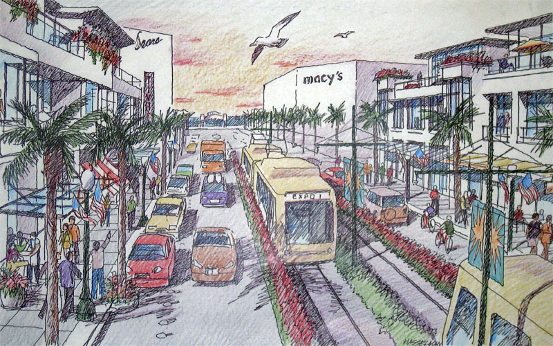 This is a Santa Monica Planing drawing. EXPO officials have stated that there is no roon for landscaping in the trackway but they will landscape the sidewalks. |
|
|
|
Post by bobdavis on Mar 4, 2009 1:08:54 GMT -8
Regarding "a railroad in your bedroom": Back in the 40s, I lived in a house with a major Pacific Electric line on the other side of the driveway (in Monrovia). One morning we almost had a Studebaker for breakfast when the driver tried to cross the track while the morning "box motor" was using it. Of course it could be that my parents got a good deal on the house because it was so close to the tracks, but I thought it was great!
|
|
|
|
Post by darrell on Mar 9, 2009 21:55:35 GMT -8
From the Expo Authority late this afternoon (and moving Phase 2 discussion back to this thread): Notice of Extension of Comment Period on DEIR from March 13 to March 27, 2009
The Exposition Construction Authority has completed the Draft Environmental Impact Report (DEIR) on Phase 2 of the Expo Line project. The DEIR studies the potential impacts to the environment that may result from adoption and implementation of one of the four proposed alternatives and identifies recommended mitigation measures.
The original comment period on this DEIR began Wednesday, January 28, 2009 and was scheduled to end Friday, March 13, 2009. The March 13 deadline has been extended to Friday, March 27, 2009. |
|
|
|
Post by darrell on Mar 13, 2009 13:51:28 GMT -8
My letter in the Santa Monica Daily Press today: If Bill Bauer were to visit downtown Phoenix he would find their newly-opened light rail tracks are mostly in boulevard medians under signal control, like the City of Santa Monica is seeking for Colorado Avenue ("City ignores safety and traffic issues," page 4, March 9).
Seattle's mile-short worlds fair monorail remains stuck in 1962, while they are completing a new 14-mile light rail line, also largely in boulevard medians, with short tunnel sections where there is no surface right-of-way.
Los Angeles' Eastside Gold Line, opening later this year, is similar.
Like recent lines in many other downtowns, including Portland, Sacramento, San Francisco, San Jose, San Diego, Salt Lake City, Denver, Dallas, Houston, Minneapolis, and Charlotte, mostly-at-grade light rail has hardly "fallen out of favor."
And "what nonsense," indeed, to claim the City Council's endorsement "was made without traffic studies or environmental reports," when those exact issues are documented in the current Expo Line Phase 2 Draft Environmental Impact Report, which found no significant traffic impacts on Colorado. |
|
|
|
Post by Gokhan on Mar 19, 2009 11:28:02 GMT -8
Expo Phase 2 route decision
Time has come for the Expo Authority board of directors to vote on the route for the Phase 2 of the Expo Line. This will take place on the Thursday, April 2, 2:30 PM, board meeting of the Expo Authority.
What they are asking now is public to come to this crucial meeting and show support for the project. Note that all the Fix Expo, Cheviot Hills, and Neighbors for Smart Rail folks will be there, bringing as many opponents as possible. Unfortunately it's always like this with such projects -- the opposition is louder than the support. Therefore, it's crucial for us to go this meeting and counter their opposition. Please try to attend and ask as many friends of you as possible to attend.
04/02/09
2:30pm
Regular Board Meeting
Kenneth Hahn Hall of Administration
500 W. Temple
Third Floor
Board of Supervisors’ Hearing Room 381 B
In Expo Authority's words:
... As mentioned the Expo Authority Board will be meeting on April 2nd per the information above to choose the locally preferred alternative. If you are available to come out and provide your public comment, it would be greatly appreciated.
|
|
|
|
Post by spokker on Mar 19, 2009 13:41:08 GMT -8
Hey, I'm on Spring Break that week! Maybe I'll show up and see what this Expo circus looks like in person  |
|
Adrian Auer-Hudson
Junior Member
 Supporter of "Expo Light Rail - Enabler for the Digital Coast".
Posts: 65 
|
Post by Adrian Auer-Hudson on Mar 20, 2009 7:32:54 GMT -8
PLEASE DO. We need all the support possible. I am in Reno and cannot be there. But, so wish that I could.
|
|
|
|
Post by darrell on Mar 26, 2009 12:27:55 GMT -8
From Friends 4 Expo Transit: ------------------------------------------------------------- Expo Line Draft EIR home stretch! The Expo Line phase 2 (Culver City to Santa Monica) Draft EIR (Environmental Impact Report) is in its home stretch! 1. Your comments are needed now: the deadline is tomorrow, Friday, March 27. Click to email phase2@exporail.net and copy the Expo Authority Board members. It's important for Expo Line supporters to be on record. You can simply state your route preference, or write details of environmental impacts significant to you. These will be reported to the Expo Board and added to the Final EIR in the fall. Friends 4 Expo has endorsed option LRT-2, the Exposition right-of-way and Colorado. The right-of-way has 2/3 the cost of Venice-Sepulveda, 4-6 minute faster travel time, greater ridership, and fewer environmental impacts. Colorado Ave. in Santa Monica has lower cost, fewer impacts, and smaller scale than Olympic Blvd. Click for F4E's full comments (PDF). 2. The Expo Authority Board will decide which options go forward into the Final EIR at its meeting next week, Thursday, April 2, 2:30 p.m. If at all possible come to the meeting and speak for the Expo Line! ________________________ See the NEWS page at friends4expo.org for more. |
|
|
|
Post by darrell on Mar 26, 2009 15:02:04 GMT -8
From today's LA Times: Santa Monica rail yard idea stirs alarm at arts complexNearby residents suggest Bergamot Station as a site for an Expo Line maintenance yard. They don't want the facility built, as now proposed, close to their homes. By Martha Groves March 26, 2009 Over its 15-year existence, Bergamot Station in Santa Monica has evolved from a ramshackle Southern Pacific rail yard turned water-heater factory into a world-class destination for art lovers. Its dozens of galleries, the Santa Monica Museum of Art and other artsy operations -- housed in scattered warehouse-style buildings clad in corrugated metal -- each year attract hundreds of thousands of visitors, many seeking the Bergamot Cafe's signature mint lemonade. So revered is the erstwhile Red Car stop, which dates to 1875, that city officials have designated it the heart of an arts and entertainment area that is expected to blossom fully once the long-awaited Expo Line light rail comes to town in a few years. It therefore came as dreadful news to gallery owners and other tenants that a suggestion is bubbling up that Expo Line officials should consider using the property for a maintenance yard. About 25 of them gathered at the cafe Wednesday morning to hear from Wayne Blank about plans for a letter-writing and e-mail campaign to squelch the idea. Blank, co-owner of Shoshana Wayne Gallery, is the man Santa Monica tapped in 1993 to develop the complex. Bergamot Station is slated to have a station along the route, which will run from downtown to near the ocean. The maintenance yard proposal, Blank noted, has come not from Expo Line officials, whose draft environmental report identifies a nearby industrial property owned by Verizon as their location of choice. Rather, the idea is being floated by nearby residents who oppose having a 24-hour-a-day maintenance yard across the street. "I'm really supportive of the train coming through, and I love going to the art shows at Bergamot Station," said Michael Tarbet, a spokesman for the area's mainly low- and moderate-income tenants. "But it's only fair to look at it as a possible alternative. "This is the only minority community in town," he said, "and it seems unfair to burden it again." The area's previous burden was imposed in the 1960s, when construction of the 10 Freeway split what is known as the Pico neighborhood in half. The highway displaced many families and ensured that those remaining would be subjected to steady doses of noise and pollution, Tarbet said. Particularly affected were residents of Delaware and Virginia avenues and Exposition Boulevard. The site proposed for the Expo Line yard is on Exposition near Stewart Avenue, just east of Bergamot Station. Santa Monica bought Bergamot Station in 1989 from Southern Pacific Transportation Co. with $17.3 million from its city bus line and county transportation funds. City Council records from August 1989 state: "Its shape and overall size make it a good location for a rail car storage and light maintenance yard." But city officials say the site has become such a valuable cultural center that it no longer makes sense to convert it. Nor do they approve of using the Verizon site, given its proximity to residents. "Neither site is appropriate," said city planning director Eileen Fogarty. She added that the city and the Exposition Construction Authority, the agency created by the state to design and build the $2-billion-plus project, have agreed "to work with a broker to come up with an appropriate site west of the 405 [Freeway] . . . that meets their needs and is acceptable to the city." Samantha Bricker, the authority's chief operating officer, said that although the agency has agreed to work with the city to identify other locations, "right now the [Verizon property] is being recommended as the site." Bergamot Station, she added, was "never studied. It's a non-starter." On April 2, the authority's board is scheduled to discuss the Expo Line's route through Santa Monica. The city has urged that, after Bergamot, it continue along Colorado Avenue. A decision about the maintenance yard will not be made "any time soon," according to Bricker. Gallery owner Craig Krull said he is optimistic that the city and the authority will agree on a suitable site for the yard and that it won't be Bergamot Station. "It would be a shame," he said, "to miss the golden opportunity to build upon what we have and make it even better." martha.groves@latimes.com |
|
|
|
Post by Gokhan on Mar 26, 2009 23:31:15 GMT -8
The following are my public comments on the Expo Line Phase 2 DEIR.
March 26, 2009
Ms. Monica Born, PE, Phase 2 Project Director
Exposition Metro Line Construction Authority
707 Wilshire Blvd Ste 3400
Los Angeles CA 90017-3520
mborn@exporail.net
Dear Ms. Born,
The following are my public comments on the Expo Line Phase 2 DEIR. Please evaluate them before you make your recommendations to the board of directors and subsequently finalize the EIR.
Yours sincerely,
Public comments on the Expo Line Phase 2 DEIR
1) The Pacific Electric Santa Monica Air Line railroad right-of-way through northern Palms and southern Cheviot Hills and Rancho Park offers the significantly better route option.
a) This route ensures the continuity of the light-rail experience and greatly increases the patron satisfaction. The alternative that would follow street medians of Venice and Sepulveda sacrifices the ambience and feeling of the natural railroad right-of-way, which will psychologically discourage riders, also given several sharp bends and greater distance.
b) Moreover the railroad right-of-way is faster.
c) It is expected to draw more ridership.
d) The railroad right-of-way will serve the Westwood/UCLA and Century City better through the Westwood Blvd Station. These areas are the most congested areas on the Westside.
e) And most importantly the railroad right-of-way route will be substantially cheaper.
f) It’s also important from the environmental-justice point of view to build the line uniformly on the railroad right-of-way, regardless of the neighborhood.
2) Colorado alternative is more environmentally friendly than the Olympic alternative.
a) It doesn’t use concrete aerial structures like the Olympic alternative.
b) It’s cheaper.
c) It’s only slightly slower (a minute or less).
d) City of Santa Monica’s suggestions should only be implemented if they are found not to slow down, reduce the capacity of, or make unsafe the rail-transit operations.
i) Right-of-way narrowing must ensure that it can result under no circumstances pedestrian fatalities arising from pedestrians being sandwiched in between two trains. If that could ever be the case, it would constitute a technical design-safety flaw that could have been prevented.
ii) Intersection-corner-radius increases should be sacrificed only if it can be ensured that the traffic will not be blocked or will not interfere with LRT.
3) Westwood Station is the most important station for Phase 2.
a) It will serve Century City, Westwood/UCLA, and the surrounding area.
b) The neighborhood is too complex and congested to be served by the Sepulveda Station alone.
c) Sepulveda Station alone would result in a too long distance between the Palms/National Station and the nearest station to the west of it in this dense residential and commercial region.
d) The unpaved Exposition Blvd North and South between Westwood and Sepulveda must be paved in order to provide easy shuttle, kiss-and-ride, and park-and-ride access to the station.
e) Enough bus zones should be provided on Westwood and Overland.
f) Enough parking should be provided for the station.
g) The bicycle and pedestrian path should be nicely integrated with the station area.
h) The station area should be designed as a green corridor as much as possible.
4) Storage and maintenance facility is necessary and it should be implemented in the optimal location, which is near the end of the line.
a) If it is near residences, sound walls and landscaping must be provided.
b) The proposed Verizon site appears to be very suitable for this purpose. Otherwise, the Mercedes–Benz dealer site between 11th and 14th Streets and the lots to the south of it could be used. The right-of-way then could be extended so that it merges the median of Colorado Ave at 11th St, instead of the currently proposed 17th St.
c) The bike path should be routed through the north of the facility, not the south of the facility.
5) The bike path should be implemented in the most useful way possible.
a) Bike bridges should be provided at Venice/Robertson and Pico/Sawtelle and possibly at Motor/I-10.
b) The restricted-use easement just west of Motor on the north side of I-10 should be used for the bike path.
c) Bike paths should be designed for bicycle and pedestrian dual use.
d) The bike path should be routed through the north side of the Verizon site.
6) High-speed gated at-grade design is the most environmentally friendly option if feasible.
a) Expo Authority’s extensive studies through three independent subconsultants have shown that gated at-grade running is safe at Overland, Westwood, Sepulveda, Barrington, and Centinela.
b) LADOT’s DEIR comments to the Expo Authority express concerns about at-grade running at these five crossings, but they do not back it up by a comprehensive study. Moreover, Expo Authority has already addressed most of these concerns through their comprehensive study performed by three independent subconsultants. It looks like LADOT’s comments are biased under influence of the local homeowners’ associations and neighborhood councils, which do not necessarily represent the entire community, given that most residents in the area, who are busy middle-class, live in apartment buildings and they don’t actively participate in such organizations.
c) Westwood and Sepulveda are safest at-grade crossings due to low speed (~ 20 MPH because of presence of a station).
d) 35 MPH Overland crossing (speed limited because of the curvature of the tracks) is also considered low-speed and hence safe. Very few school children walk on Overland to or from school. Gated LRT crossings are much safer for school children than the four freeway ramps on Overland, a few blocks south.
e) Overland, Westwood, and Sepulveda are all in or by single-family residential neighborhoods. At-grade design without intrusive heavy infrastructure such as aerial guideways, retaining walls, and rail bridges is best for these neighborhoods. Also, in such neighborhoods, traffic is less congested than in commercial neighborhoods. Therefore, Overland, Westwood, and Sepulveda are top candidates for at-grade design.
f) Although I support the at-grade proposals by the authority at Barrington and Centinela, I note that these are high-speed (55 MPH) crossings with limited visibility in a dense, usually congested commercial area and the level of service at especially Barrington is very low. Therefore, despite supporting at-grade design at these two crossings, I caution the authority that these two crossings are most likely to be contested by CPUC, due to their potential safety risks.
g) At Overland, Westwood, and Sepulveda crossings, the push by LADOT is somewhat political, resulting from the influence of homeowners’ associations and neighborhood councils in this area. Note that these three crossings, if grade-separated, may induce environmental-justice problems when compared to similar Phase 1 crossings. As an example Vermont Ave in Phase 1 was left at-grade despite having a 2020-projected traffic count of 678 vehicles/lane/hour and level of service of D/D, for AM/PM peak periods respectively. With no build the 2020-projected level of service for Vermont Ave was C/B, for AM/PM peak periods respectively.
h) Additional traffic lanes proposed at these streets is reasonable. But I strongly request that lanes are slightly narrowed (by about six inches) and the existing curbs are not modified. This is very important in order to preserve the trees, parkway, and distance to the residences on these streets.
i) Wherever grade separation is required, aerial guideways supported on columns should be used. This will allow the continuity of the area accessible through under these structures, provide space for facilities—including parking—under these structures, and provide visual continuity as viewed from either side of the structures. The height of the structures should be minimized, using minimal clearances for the vehicles that will pass under these structures. In order to minimize the height, depressed streets under the structures should be used where feasible. Retaining walls should only be used at LRT ramps and their heights and lengths should be minimized by using embankments and landscaping.
7) Plan and build an interface designed for a future Expo–Purple Lines Connector.
a) There are two arcs near Exposition and Sepulveda that connect the Expo Line railroad right-of-way to a former Pacific Electric railroad right-of-way along Sepulveda Blvd in the north direction. This junction is historically known as the Home Junction. The Phase 2 of the Expo Line should be built so that there could be a Purple Line Connector through these two arcs and then headed along Sepulveda Blvd in the north direction toward the future Purple Line. The connector itself could be at-grade, below-grade, or elevated light-rail. But, regardless, these arcs are an opportunity for this connector, and the Phase 2 should be built in such a way that it doesn’t preclude this connector to the future Purple Line through these arcs and Sepulveda Blvd.
8) Plan and build an interface designed for a future Expo–Green Lines Connector.
a) Although the 4th/Colorado Station platform unfortunately dead-ends at 4th St/I-10 off ramp, if the vertical level of the end of the tracks at this location can be optimized for a future elevated freeway off ramp and a depressed Pacific Coast Highway/I-10, then the tracks could extend under an elevated freeway off ramp and over a depressed Pacific Coast Highway/I-10 to connect to an Expo–Green Lines Connector along Lincoln Blvd or another alignment. Therefore, this should be considered for the vertical alignment of the end of the 4th/Colorado Station platform in order to optimize it for a future extension toward the Green Line. Note that the Pacific Electric Santa Monica Air Line historically continued from Santa Monica toward Venice and Inglewood.
9) Plan and build an interface designed for a future Expo–Venice–Culver Connector.
a) The junction historically known as the Culver Junction at the intersection of Venice/Robertson and nearby Venice/Culver Boulevards was the railroad junction for the Pacific Electric Santa Monica Air Line (currently Expo Line), Venice Short Line (currently Venice Blvd), and Inglewood Line (currently Culver Blvd) rights-of-way. Plan, design, and build the line at the Culver Junction (Venice and Robertson) in such a way that future extensions along Venice Boulevard and along Culver Boulevard are possible.
|
|
Adrian Auer-Hudson
Junior Member
Supporter of "Expo Light Rail - Enabler for the Digital Coast".
Posts: 65
|
Post by Adrian Auer-Hudson on Mar 27, 2009 7:39:28 GMT -8
The published public comments are pretty much right on. I especially like number nine. I have thought for a while that the old Culver Blvd RoW would be a great starter line for reaching LAX.
|
|
|
|
Post by kenalpern on Mar 27, 2009 15:26:11 GMT -8
As Adrian and others know, the discussion of an Expo/Culver/Lincoln route to LAX has long been discussed by TTC as a way to link the different regions of the Westside to the Expo Line and to each other.
|
|
|
|
Post by spokker on Mar 29, 2009 15:50:42 GMT -8
Is there a good summary of the arguments against using the existing right of way for phase 2?
What are the benefits, if any, of not using the existing right of way and using the alternative?
I'm just trying to see why some oppose using a perfectly good right of way that already exists.
|
|
|
|
Post by bluelineshawn on Mar 29, 2009 16:50:01 GMT -8
I think that everyone agrees that using the existing ROW will be faster and cheaper to build and the trains will run faster to Santa Monica. The downside is that the ROW bypasses many businesses along Venice and of course all of the NIMBY's that don't want the trains near them. And as I understand it the increased riders heading to Venice will be more than offset by less riders total because of the longer running time along the length of the route.
At the risk of being called names here, as is becoming common, I like the idea of running the line along Venice and losing a couple of minutes in the total running time.
|
|
|
|
Post by Gokhan on Mar 29, 2009 18:05:49 GMT -8
I think that everyone agrees that using the existing ROW will be faster and cheaper to build and the trains will run faster to Santa Monica. The downside is that the ROW bypasses many businesses along Venice and of course all of the NIMBY's that don't want the trains near them. And as I understand it the increased riders heading to Venice will be more than offset by less riders total because of the longer running time along the length of the route. At the risk of being called names here, as is becoming common, I like the idea of running the line along Venice and losing a couple of minutes in the total running time. Well, if you build on Venice, then you will bypass many businesses on Pico, which is served by the ROW alignment. It's true about NIMBYs but even them have accepted that the line will be built on the ROW. Answering spokker's question: The main advantage of the diversion (Venice/Sepulveda) is that it serves Mar Vista better than the ROW alignment. The main advantage of the ROW alignment is that it serves Westwood/UCLA/Century City better. I think many people will agree that Westwood/UCLA/Century City needs light-rail much more than Mar Vista, not to say that Mar Vista doesn't need it at all. See the Page 2-41 under Project Alternatives for the detailed station boardings. Palms is served equally by both alignments, either through Palms/National, which I think is a better hub though, or Venice/Motor. Mar Vista is served by Venice/Sepulveda and National/Palms. Westwood/UCLA/Century City served by Westwood/Exposition. Some people will argue that one day Purple Line will be built. But (1) it's a long time from now and (2) it won't connect Westwood/UCLA/Century City to Palms/Culver City/USC/South LA like the Expo Line, which is the most important argument to build Expo on the ROW. I will also argue that one day there will be a line on Venice and there will be a line on Sepulveda as well. But the thing is that if the ROW is bypassed now, it will be lost forever. And then there are obvious reasons as saving several hundred million dollars, double the ridership to Westwood/UCLA/Century City than the diversion alignment, more ridership overall, much less property takes, etc. And my addition to all these arguments is the importance of preserving the ambience of the right-of-way for the patrons and environmental justice of not skipping more affluent neighborhoods. I think ROW is no brainer. The diversion was something that was brought by Zev and Yvonne in early 2000s, during the old DEIR that ultimately went into trash, after finding that the impacts at Sepulveda would be too severe. If Zev and Yvonne hadn't brought it up, it wouldn't even have been an alternative now. Yvonne had promised Cheviot Hills that Expo would never be built on the ROW during her time. She's just gone and replaced by Mark Ridley-Thomas. Zev had said "Why build it on a route with opposition?" He now understands the importance of building the line on the right-of-way, and sympathizing with the light-rail NIMBYs is a thing of the past for him. |
|
|
|
Post by kenalpern on Mar 30, 2009 5:36:33 GMT -8
Gokhan's statements pretty much say it all. As a Boardmember of the Mar Vista Community Council (the neighborhood council of Mar Vista and Westside Village), I've been at the center of enhancing Rapid Bus service, complete with stations and parking structures, to help establish a Venice Blvd. "Expo Connector" that would pretty much enhance transit service on Venice Blvd.
Such transit service would fill in most of--if not all of--the blanks left on Venice Blvd. from an Expo Line on the ROW to service the regions of Palms, Mar Vista, Venice, Del Rey, Culver City and Marina Del Rey. A relatively cheap Venice Blvd. Orange Line-like service--with stations and parking/bicycle/pedestrian/TOD nodes that I like to call the "Expo Connector" would be a perfect way to ensure both optimal Expo Line access and ridership as well as a comprehensive mass transit plan for the Westside in general.
|
|
|
|
Post by darrell on Mar 30, 2009 13:28:12 GMT -8
The Expo Authority staff report for Thursday is posted (PDF). It looks rather as I'd expected: it calls for LRT 2 (right-of-way and Colorado) as the preferred alignment going forward into the Final EIR, and calls for continued work with cities and stakeholders during the FEIR process on issues raised during the DEIR - Grade Crossings, Maintenance Facility, and Bikeway. |
|
|
|
Post by metrocenter on Mar 30, 2009 13:58:53 GMT -8
This is getting there, slowly but surely. Use of the ROW is now pretty much a settled issue, so far as I can see (whatever the repeated disclaimers say). Going forward, the question will be "how", rather than "if".
The grade crossings will continue to be an issue. I'd be surprised if all the controversial at-grade crossings remained at-grade. The issue is not safety but traffic. Especially at Westwood, Sepulveda and Barrington.
I'm also wondering where they will put 170 parking spaces at Expo/Westwood.
|
|
|
|
Post by joshuanickel on Apr 1, 2009 16:29:33 GMT -8
Is anyone going to the meeting?
|
|
|
|
Post by darrell on Apr 1, 2009 17:43:29 GMT -8
Is anyone going to the meeting? Of course! Seriously, it would be great for everyone here who can to attend and speak. I'll be supporting the staff recommendation and making a few specific comments about the three areas of continued study: grade separations, maintenance facility, and bikeway. |
|
|
|
Post by Gokhan on Apr 1, 2009 20:30:22 GMT -8
I'll be going, as well as other supporters. And, certainly, the NIMBYs are going, too (see below). Isn't it ironic that the comment period was extended two weeks at the request of the NIMBYs and now they are claiming that the end of the comment period is too close to the decision date and therefore the decision should be postponed?
Dear Westwood Gardens Neighbors and Friends:
News and events regarding the Expo Train.
====================================
The Chief Executive Officer for the Expo Authority is recommending that the Expo Board choose Route 2 which is on Expo Right Of Way through our neighborhood going on Colorado to the end which is now Sears. (LRT2)
They will be voting tomorrow. We will be there asking how they can possibly choose a route when the public's DEIR comments were submitted less than 1 week ago!
Our Westwood Gardens comments were over 25 pages as was West Of Westwood. Neighbors for Smart Rail's comments were 57 pages with 14 attachments. Not to mention the comments from WNC, Cheviot Hills HOA, Tract 7260 HOA, and many many others. All dealing with the inadequacies of the Expo DEIR. Yet under the Oppose section under "Overview of Major Comments" were only these 2:
"No money available to build it and no one will use it"
"Adversely affect quality of life"
Please review the attached report.
The MTA Board Meeting will be tomorrow, Thursday:
2:30pm
Regular Board Meeting
Kenneth Hahn Hall of Administration
500 W. Temple
Third Floor
Board of Supervisors’ Hearing Room 381 B
--------------------------------------------------------------------------------
--------------------------------------------------------------------------------
March and Rally:
There is a very important march and rally this Saturday morning. The community that has been fighting the MTA to make the Expo line Phase 1 safe for school children in their area will be marching from Foshay Learning Ctr to Dorsey High. There will be press there. There will be folks from Overland PTA there as well. Their community has supported our efforts against the Expo Authority's plans for this train through our neighborhood and we have supported theirs. What happens on Phase 1 will happen on Phase 2. I will be there with my kids to show support as I have in the past and I hope you will be there too.
|
|
|
|
Post by joshuanickel on Apr 1, 2009 21:19:21 GMT -8
They claim that there is no money to build it yet when they buy their stuff to put in their homes, they are paying for it with the measure R sales tax that starts on July 1st I'll be going, as well as other supporters. And, certainly, the NIMBYs are going, too (see below). Isn't it ironic that the comment period was extended two weeks at the request of the NIMBYs and now they are claiming that the end of the comment period is too close to the decision date and therefore the decision should be postponed?Dear Westwood Gardens Neighbors and Friends:
News and events regarding the Expo Train.
====================================
The Chief Executive Officer for the Expo Authority is recommending that the Expo Board choose Route 2 which is on Expo Right Of Way through our neighborhood going on Colorado to the end which is now Sears. (LRT2)
They will be voting tomorrow. We will be there asking how they can possibly choose a route when the public's DEIR comments were submitted less than 1 week ago!
Our Westwood Gardens comments were over 25 pages as was West Of Westwood. Neighbors for Smart Rail's comments were 57 pages with 14 attachments. Not to mention the comments from WNC, Cheviot Hills HOA, Tract 7260 HOA, and many many others. All dealing with the inadequacies of the Expo DEIR. Yet under the Oppose section under "Overview of Major Comments" were only these 2:
"No money available to build it and no one will use it"
"Adversely affect quality of life"
Please review the attached report.
The MTA Board Meeting will be tomorrow, Thursday:
2:30pm
Regular Board Meeting
Kenneth Hahn Hall of Administration
500 W. Temple
Third Floor
Board of Supervisors’ Hearing Room 381 B
--------------------------------------------------------------------------------
--------------------------------------------------------------------------------
March and Rally:
There is a very important march and rally this Saturday morning. The community that has been fighting the MTA to make the Expo line Phase 1 safe for school children in their area will be marching from Foshay Learning Ctr to Dorsey High. There will be press there. There will be folks from Overland PTA there as well. Their community has supported our efforts against the Expo Authority's plans for this train through our neighborhood and we have supported theirs. What happens on Phase 1 will happen on Phase 2. I will be there with my kids to show support as I have in the past and I hope you will be there too. |
|
|
|
Post by stuckintraffic on Apr 2, 2009 0:24:41 GMT -8
I'm a new poster here so I just wanted to say first of all say hello to everyone.
I've only recently become aware of efforts to bring the Expo Line to the Westside. As a lifelong resident of West LA, I've been following developments surrounding this line with a close eye... Sitting in the worst traffic on earth day in and day out, I've often wondered why in the world there is no real mass transit in this area. So I'm excited that we're getting a rail line!
As someone who WILL use this line frequently to get from Mar Vista to downtown Santa Monica, I would like to see that this line gets built in the best way possible.
That said, I still cannot figure for the life of me why anyone would want the Colorado option over the Olympic one. The Colorado option is slower, plain and simple, and it will adversely affect car traffic more than the Olympic option because, instead of going over some of those final streets near the terminus in SM, it will go across them at-grade.
Here are my thoughts I wrote down a couple weeks ago. I thought I'd share them here:
When I found out they wanted to put the train on Colorado and not Olympic because they wanted to save some not-so-spectacular trees, I decided to scope out the area myself. I thought the support behind the Colorado alignment indicated the Colorado stretch would be some amazing thing. Honestly, after taking a gander at the area, I was less than excited about it.
First off, I observed that Lincoln is an incredibly busy street, and I was surprised that here was a chance to get the train off of a crowded street (the Olympic alignment goes elevated at Lincoln and all the way to the terminus) but people would rather not take that wonderful opportunity and instead put it in a place that has the possibility of underperforming speed-wise (at least compared to the Olympic option).
At this point, I thought, "Well maybe everyone knows something I don't about this amazing proposed pedestrian promenade." If it helped the streetscape and made the area better looking (the primary argument for not putting it down Olympic -- it will hurt those oh-so-beautiful trees) then that would be a good reason to sacrifice speediness and traffic mitigation. And, after all, that rendering they released of the Colorado terminus with the sea gulls flying above and the impossible-to-install median landscaping looked pretty terrific.
So, I scoped out the area near that Sears building at the end of the line. To be honest, it's not that impressive, nor is there a lot of potential for improving it into some great pedestrian space. At the corner of Lincoln there is a huge power station of some sort, and the south side of Colorado between Lincoln and 5th building is dominated by a huge bus yard. Aside from that, you have a few warehouse-like commercial spaces and some less-than-busy storefronts. I understand the mode of thought is that you can use the train to invigorate the area, but the power plant and bus yard had me thinking this would be a tall order to fill. (I concede that I am not familiar with any sort of community plan that may exist to to move these things; if anyone has any info about that, I would love to hear it).
Add to that the fact that really the only stop here for pedestrians will be 14th street, and it got me thinking that this great pedestrian promenade has not been thought out very well.
It seemed to me like a confusion of priorities. To me, the Expo line is an arm of our rapid transit system. If SM wants a streetcar, I think they should put in a proper streetcar that stops very frequently and runs slowly (20 mph) in order to promote pedestrianism in the area. I don't see why you'd want to hurt regional mobility (slowing down the Expo line for a streetcar segment) to lend to a cause (pedestrian promenade) that I don't believe is very promising.
---
Bottom line: it boggles my mind why anyone wouldn't want Olympic. The aerial structure doesn't have to be ugly, and those trees are not endangered redwoods!
Also, I'm wondering if any planning has been or will be done to make whatever routing is chosen (Colorado or Olympic) compatible with the much-talked-about Green line extension that would go up Lincoln and connect with the end of Expo. Have they thought of how these will connect or how multiple lines of trains running down the same tracks will affect traffic?
Similarly, has the Robertson station of the Expo line (that goes over Venice Blvd) been designed to account for a future interface with a line down Venice?
Or, in a line that will sooner come into play, has the Expo Line at Crenshaw been designed to allow the Crenshaw line to go through/over/below it (Crenshaw line will eventually cross Expo on its way to Wilshire)?
I realize the first two examples are not so close to happening; however, the Crenshaw/Expo interface is definitely something beyond pie in the sky.
All of these things are important because they will ultimately mean $$$ if these future lines dictate that the lines we are building now will have to be rebuilt to accomodate. Or, worse yet, planners will have to build the line in a less-than-optimal way in order to save face so that they don't have to demolish a station they designed only 5 years prior.
We're seeing this now with the Downtown connector, where no one thought beyond 3-5 years with the placement of the Little Tokyo station. Many have known the DT connector to be a necessity for a while, and yet the Gold Line Little Tokyo station (still not even done!) was placed in a way that creates all sorts of problems for the engineers and designers taking the helm with the DT connector. They now face the contraints of having to build the DT connector in a way that doesn't destroy the Little Tokyo station because doing so would cost more money and would highlight the lack of foresight put into planning the Gold Line.
Going back to my Expo example -- it looks like they're close to choosing Colorado now, but what if in 25 years when they go design the Green Line extension they determine Colorado can't handle the extra capacity? Then they ultimately have to build the stretch from Lincoln to 4th via Olympic anyway. Not saying that's a for-sure but I haven't heard that enter the discussion at all...
I think that, instead of initiating all these piecemeal alternatives analysis studies for segments of lines, Metro/County of LA need to use some of this Measure R money to invest in one large-scale alternatives analysis (even EIR?) for an entire LA Metro system that incorporates all projects on the table for the next 50 years. That way, we would all know what is getting built and where, and we could plan accordingly. While all might not get built in our lifetimes (or at all) and the far-off projects would no doubt have to later be updated with supplemental studies (to account for changes in pop, density, etc), the benefits of adopting such a practice would be self-evident.
|
|
|
|
Post by darrell on Apr 2, 2009 8:21:08 GMT -8
I'm a new poster here so I just wanted to say first of all say hello to everyone. Welcome! I'll try to give some short answers below. Have you seen the City of Santa Monica staff report? In particular it opposes Olympic's elevated entrance into downtown Santa Monica (their image below): "This elevated structure at the entrance to downtown will detract significantly from the City’s character, scale and desired pedestrian environment."  City of Santa Monica planning staff recommended the Colorado alternative last fall, developed by consultant Robert Odermatt, who was involved in the design of light rail in downtown Portland and San Jose (photos below). 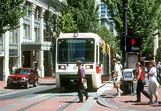 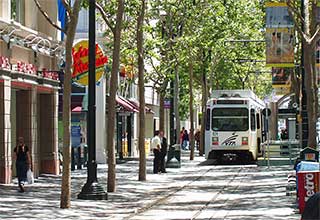 This Expo Authority image is a good representation of the trackway down Colorado. Trains would operate at 30 mph (the street's speed limit) under signal control for the one mile between the 17th Street station and the 4th Street terminus at Sears Auto Center. (Conversely they'd be at 35 mph under signal control on Olympic between signals at 20th and 14th, before going aerial at 11th.) 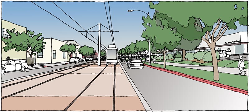 The city should be able to give trains signal priority at all of the intersections except Lincoln, which is tied in with the freeway ramps' signal timing. So trains may wait part of a cycle before crossing Lincoln on that green light. The net is Colorado is only about one minute slower than Olympic. Gokhan and I have suggested making the terminus station compatible with trains running through to the south. Think of a curve to the east above the I-10 freeway, then heading south along Lincoln. Did you see the City of Los Angeles RFP for Westside Transporation Studies - including Lincoln - that was just released? Light rail would be a difficult fit along Lincoln, though. 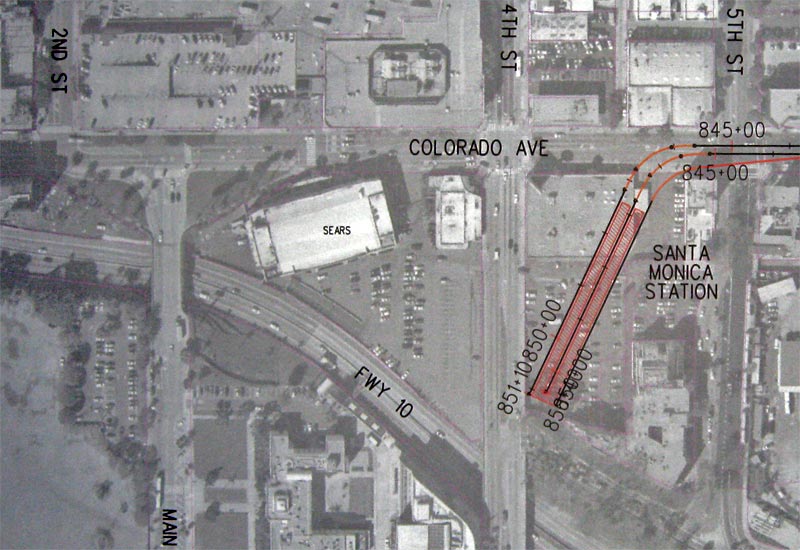 No, in part because such a line down Venice would involve multiple bridge sections, not a simple project. Ken Alpern and others are advocating for a Rapid bus line from the Culver City Expo staiton down Venice. That was originally in the Crenshaw plans, but the trunk of the Expo Line from Crenshaw to 7th & Flower does not have the capacity for a third branch to be added. |
|
|
|
Post by stuckintraffic on Apr 2, 2009 11:23:40 GMT -8
About the drawing of the Olympic elevated terminus -- I think that's a terrible rendering. It looks like it was thrown together in about a half an hour. No detail at all. Looks like very basic Photoshop gradient textures. It looks like it was created by someone with an agenda to show how bad it could look.
Secondly, I don't think that the elevated structure would look bad at all. You'd have a nice view from the top waiting for the trains, and from the train entering the station you'd also have a nice view of the city and perhaps the beach. There are lots of ways to make it ped friendly. I'm surprised no one thought of putting retail or perhaps a Metro information center below at street level. Or at the very least landscaping and vendors.
I live in the area and so I want to see something that helps beautify the city. I think that if done right the elevated could do this. I also think those trees are scraggly, not endangered, and in the middle of a roadway. They're not worth saving at the expense of a minute per day for every rider that takes that train ad infinitum. They can plant new trees in their place (and proposed renderings showed this).
|
|
|
|
Post by JerardWright on Apr 2, 2009 11:54:39 GMT -8
... of the Olympic elevated terminus -- I think that's a terrible I live in the area and so I want to see something that helps beautify the city. I think that if done right the elevated could do this. I would agree with that sentiment because elevated stations and structures can be designed to incorporate themselves into buildings or even have the strucutre cladded so that it mimics the nearby structures. I'm of no major preference one way or the other regards to the Colorado or Olympic alignment, but something to ponder about accessing the station. If it's only one minute that is lost travelling between station platform to station platform between the elevated terminal and the at-grade terminal, that one minute will be negated by the very climbing of stairs and or walking up escalators to reach the elevated platform. Considering that along Colorado there are MTV, Yahoo, Sony and other major companies that are making Colorado it's home, it makes sense to link those pieces together with Downtown. |
|
|
|
Post by Jason Saunders on Apr 2, 2009 13:48:03 GMT -8
First, the rendering of the elevated station is drawn to make the station appear unappealing and your right stuckintraffic, the image does feel like it has an agenda. Second, The Colorado alignment will probably look like the below image of the East Side Gold Line extension now under construction. This of course is the "cheapest" option. Which is what they are going for; "cheap" farm3.static.flickr.com/2217/2332140942_5a46f618a0.jpg?v=0Third, the elevated is not less pedestrian friendly. It is more. How is a train weighing thousands of pounds slowly going down the street shared by pedestrians at intersections more pedestrian friendly? How does the removal of parking spaces (parked cars create a buffer between moving cars and pedestrians) and the removal of some sidewalk space create a more pedestrian friendly environment. Also, the consensus was that there is no room for landscaping under this option so you can expect to see very "hard" surfaces. Make no mistake, this portion of the alignment will be a "bus on rails" stopping at major intersections and waiting at lights just like a rapid bus would do. It will not be innovative. It will not be aesthetically pleasing. (the station might but not the rest of it.) It will not look like the two smaller images Darrel presented unless Colorado is going to be majorly revamped to be something closer to Third Street Promenade and it will not be as efficient as it should. Some people who post on these boards think our choices are to build it cheap or for it not to be built. Others think we should invest in making it more efficient and that grade separation can be attractive. L.A. needs transportation solutions not tourist trolleys. If S.M. wants a Pacific Electric tourist trolley they should build one that connects to the modern efficient rail car. I speculate the Expo board, which meets today in downtown Los Angeles will go with the city of Santa Monicas stated preference of at grade on Colorado. The city would like at Grade on Colorado because the schools on Olympic did not want the train going down Olympic. To the best of my knowledge grade separation on Colorado was not studied or eliminated very early in the process. It is now late in the game so I think we're getting at grade on Colorado. |
|
|
|
Post by Gokhan on Apr 2, 2009 17:32:47 GMT -8
**** The Pacific Electric Santa Monica Air Line railroad right-of-way has been adopted for the Phase 2 segment of the Expo Line. ****
After 20 years of fight against the NIMBYs, it's all over. Today the Pacific Electric Santa Monica Air Line right-of-way that goes through northern Palms, southern Cheviot Hills, and Rancho Park has been adopted for the Expo Line. The board has voted unanimously with all members present.
The motion has adopted the Air Line right-of-way and the Colorado Ave alignment, i.e. LRT No. 2.
The motion additionally directed the Expo staff to address all the comments raised during the DEIR and work further on sensitive areas such as grade separation and maintenance facility. It asked the staff to come back to the board with a report on these sensitive areas in 60 days.
The DEIR process is now complete, with the route adopted. The next step is to finalize the EIR and generate the FEIR, making changes to the details as necessary. The FEIR will also include some form of preliminary engineering. FEIR will be completed by the end of the year and will be certified by the Expo board. Once the FEIR is certified by the Expo board, the project will be official and it will be submitted to the design - build company in early 2010, to be completed circa 2014.
I should mention that all board members were very supportive of the DEIR. Zev Yaroslavsky in particular was very considerate about possible impacts and raised issues about street striping that need to be addressed. He also stressed very strongly that this line will be built no matter what, while addressing the faction of various homeowners'-association presidents and officials from the Westside. He made it clear to their face that there is no other way. He said that delays will not be tolerated because we needed this now. He also emphasized that grade separations in Phase 2 will be determined exactly in the same way as in Phase 1 and there will not be any environmental-justice issue. He also made it clear that the maintenance facility will be in Santa Monica and it cannot be underground. He gave the large West Hollywood bus facility (former Pacific Electric major rail yard) as an example saying that it's literally adjacent to residences (not just across the street like the Verizon facility) and it had been determined that it was not feasible to put it underground. Zev also stressed that the Westwood Blvd Station is the most important station for Phase 2 and, addressing the homeowners'-associations-presidents faction, he said that he knew they didn't want it but it was needed absolutely and it would happen.
Out of the 53 people who spoke for a minute today, an overwhelming majority were supporters, except for a faction of homeowners'-association presidents and officials from the Westside, all supporting the railroad right-of-way. This faction left the meeting unhappily, but I hope that they understand the importance and benefit of this project.
My impression now is that Expo Phase 2 is now on autopilot and I don't expect any problems further down on the road. Things should go very smoothly from now on.
|
|
|
|
Post by Gokhan on Apr 2, 2009 17:46:07 GMT -8
Another note from the Expo board meeting today:
Fix Expo stated that they will launch a nuclear war on April 24. They said that this is environmental racism and since Phase 1 is federally funded (which is hardly true in reality), they will stop both Phase 1 and Phase 2 and annihilate the federally funded Westside subway extension, as well as all other future rail-transit projects.
Earlier there was a lot of mention of Dr. King's name by them, which I thought was irrelevant and disrespectful.
|
|
|
|
Post by stuckintraffic on Apr 2, 2009 18:04:03 GMT -8
why not Olympic? Don't get it...
|
|