|
|
Post by darrell on Jun 13, 2008 12:12:50 GMT -8
I think the Sepulveda crossing should be grade-separated, due to the impact on north-south traffic. The level-of-service (calculated by MTA) at that location is currently grade B. In 2030, the MTA projects a grade C in 2030 if nothing is built, and a grade D if Expo is built at-grade. To me, that's a big hit. I see two basic criteria, what I'll call lane flow capacity and queuing length. * Lane flow capacity is limited by stopped time at signals. For example, a standard lane can carry X vehicles per hour through an intersection where the signal is red 30 seconds out of a 60-second cycle. The exercise in Monday's presentation for Overland said there is 25 minutes of red time per hour at Ashby. Stopped time for crossing gates overlaps part of that red signal time, resulting in their conclusion of 32-33 minutes of combined signal and gate-down red time per hour. That reduced flow capacity (from 35 minutes per hour to 27 minutes per hour green time) per lane would be mitigated by adding a third lane coming up to the intersection on each side. Less green time per lane x more lanes = more total time. Same for Sepulveda, adding a third southbound lane to mitigate increased red time at the Exposition Blvd. intersection / crossing. * Queuing length is simply whether stopped cars would back up across a grade crossing. Can't have that!  For example, Bundy queues all the way from Pico to Olympic in both directions, here shown at the right-of-way, and will have a bridge. The concept for Barrington is to add right-turn lanes in both directions. That third lane in each direction shortens the queue length at Olympic and Pico by as much as 1/3. With three different traffic engineering consultants looking at this, their analysis must be pretty bullet-proof. |
|
|
|
Post by Tony Fernandez on Jun 13, 2008 12:14:19 GMT -8
Right, but there's still the very high north-south traffic (people going to to Culver City, El Segundo, Westchester, etc. from Westwood, Brentwood, etc. and Vice Versa). The Red Line Extension would not really help those commutes at all, but the Bronze Line (or Sepulveda Line) would take care of those commutes. Then that would be considered the primary route for transportation along that commute area and grade separations would be a minute issue, as Jerard put it.
|
|
|
|
Post by darrell on Jun 13, 2008 12:26:15 GMT -8
The MTA is really in a bind. They really have to grade-separate at least one of those crossings, but if they do then that only gives Damien's environmental justice lawsuit more evidence. So, how do you mitigate this? Remember, if the Grade Crossing Policy analysis concludes a grade separation is required, that is entirely consistent with phase 1's determinations. Traffic on Venice, Pico, Bundy, and Cloverfield require grade separation. Adjacency to Venice brings in Washington-National, Pico brings in Sawtelle, and Cloverfield brings in Olympic, not that those don't have heavy traffic and/or queuing issues on their own. |
|
|
|
Post by Tony Fernandez on Jun 13, 2008 12:38:16 GMT -8
Yes, I know that it's all been consistent, but I'm just saying that's not how Damien is going to argue it.
|
|
|
|
Post by metrocenter on Jun 13, 2008 12:56:23 GMT -8
metrocenter, this is actually incorrect. The figures provided for Exposition/Sepulveda are for the diversion option. The right-of-way option was approved earlier and they didn't have the figures for it in Monday's presentation. In the presentation (link), the table of grade crossings on page 7, for the Exposition ROW, makes no mention of Sepulveda, as either "at-grade", "separated", or "further analysis". An oversight, no doubt. Edit: oops, my bad! In fact, the ROW option will have an at-grade crossing at Sepulveda/Exposition. See pages 20 and 22 for discussions and images of the crossing in the ROW option as at-grade. The data in the table on page 19 is definitely unclear. Does it refer to the ROW option or the diversion option? Probably another mistake. |
|
|
|
Post by Gokhan on Jun 13, 2008 13:32:42 GMT -8
In the presentation (link), the table of grade crossings on page 7, for the Exposition ROW, makes no mention of Sepulveda, as either "at-grade", "separated", or "further analysis". An oversight, no doubt. Actually, it does; it's listed as at-grade. You overlooked it. The data in the table on page 19 is definitely unclear. Does it refer to the ROW option or the diversion option? Probably another mistake. I strongly believe that this is only for the diversion option. But I've already asked Expo about this and I am waiting for the Sepulveda figures for the right-of-way option. |
|
|
|
Post by metrocenter on Jun 13, 2008 14:26:26 GMT -8
Actually, it does; it's listed as at-grade. You overlooked it. Oh yeah, thanks. |
|
|
|
Post by kenalpern on Jun 13, 2008 21:48:33 GMT -8
There will be lawsuits and protests no matter what is decided here. At this time, the LADOT has NOT accepted these at-grade crossings, and will decide whether or not the Authority's proposals are acceptable to them.
Each intersection must be evaluated independently by the same guidelines, and if we can say that the same alterations to major thoroughfares in Phase 1 like what is being proposed for Sepulveda and Overland, then the Environmental Justice argument holds true.
If the LADOT and the Authority do not agree to the proposed changes, then Metro policy and the PUC will have to proceed with an elevated rail line at key intersections that (like La Brea and La Cienega) cannot must for traffic and safety purposes be elevated.
Environmental Justice claims are serious and must be evaluated thoroughly, but the numbers and facts must be evaluated regardless of each opinion and claim and lawsuit...and the questions of how to proceed west of Venice/Robertson are anything but decided.
|
|
|
|
Post by masonite on Jun 13, 2008 23:07:15 GMT -8
Although I'd like to see as much of Expo grade separated as possible, the one solace I take from having it at grade at some of these intersections is that the single drivers will have to yield to the Metro as it speeds by.
When I worked in Downtown LA in the 90s I was surprised at the number of people who didn't even know there was a subway in LA, and this was in Downtown where it was literally two blocks away. It just didn't have the visibility. At least with Expo people will know it is there good or bad.
|
|
|
|
Post by Gokhan on Jun 13, 2008 23:57:46 GMT -8
Here is how an Overland grade separation would look like: 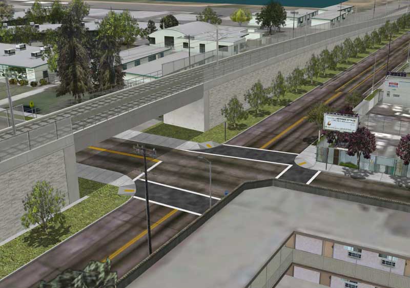 This image is Expo's rendering for a Farmdale Ave grade separation. Overland Ave and Farmdale Ave are very similar with regard to having a school and residential properties in close proximity. The main difference is that an Overland bridge would be longer, thicker, and higher. In my opinion if traffic permits, this should be avoided. Chances are that the people who ask for this: (a) Don't know what they are asking for (b) Don't give a darn about the neighbors who have homes right next to it (c) Worried that their everyday drive through the crossing might take a minute longer (d) Have kids who will be attending the school and worried that they will be distracted by bells and horns and won't get to learn and be successful adults when they grow up (e) Some combination of the above |
|
|
|
Post by roadtrainer on Jun 15, 2008 7:12:01 GMT -8
You know what? Education does wonders! Look at the schools next to the Blue Line and the Gold Line! Has there been Gang fights spill over onto the ROW's? And there are no accidents involving children at all. I think that the education department of Metro is doing great!, What I fear is "time rushed" adults who can't wait for a Metro train come and gone in less than 30 second! Sincerely The Roadtrainer  |
|
|
|
Post by bluelineshawn on Jun 15, 2008 9:15:15 GMT -8
Metro has a few cartoons about watching out for trains, but I don't think that their "education department" gets involved with gang prevention.
But you're correct about adults getting hit by trains. It could happen to anyone and since there are more adult riders it will happen to adults more than kids. This even though adults are generally more experienced than kids, which is the big difference.
And while we're on the subject most of the blue line pedestrian accidents occur when people accidentally walk in front of the second train. I think that what happens is that they hear the horns and they look and see the train coming. They focus on the train coming and step on the tracks when it passes, never realizing that there was another train coming from the opposite direction. It's startling to look at train/pedestrian accidents and see how often the circumstances are like this. I don't have any stats, but from the reports that I've noticed over the years it's probably 65-80% of non-suicide pedestrian accidents. Maybe Metro needs to put up signs to warn of this occurrence.
|
|
|
|
Post by bluelineshawn on Jun 15, 2008 9:40:11 GMT -8
this is LOS ANGELES. We're not a 3rd tier US city like that of Phoenix, Sacramento, San Jose, Sacramento, Houston, etc.... Houston - 4th largest U.S. city, not exactly "3rd tier" (2000 Census) Phoenix - 6th largest U.S. city San Diego - 7th largest U.S. city Dallas - 8th largest U.S. city San Jose - 11th largest U.S. city San Francisco - 13th largest U.S. city Note also that we're talking about one corridor within a larger Los Angeles rail network. I think that he means 1st Tier would be cities like NYC, London, Paris, Tokyo, Chicago, Los Angeles, etc. 2nd Tier would be Seoul, San Francisco, Toronto, Madrid, etc. The cities that you listed are mostly 3rd tier and lower on a world scale. LA is really kind of hard to compare to any other city when it comes to infrastructure. We're not as densely populated as older world cities, but we're much larger and more densely populated than other sun belt cities. Our needs are special. We're kind of a tweener and the transportation system that we're building reflects that. |
|
|
|
Post by damiengoodmon on Jun 15, 2008 13:41:35 GMT -8
Within America there are two recognized mega-cities: New York and Los Angeles. I'd say we're a much smaller version of Tokyo (polycentrism) with the metropolitan population and density of London.
Much of our transportation challenge stems from the multiple economic centers. For example, it would be much easier to devise a transit system that could lead to the ridership percentage of those other cities, if we only had to feed Downtown and/or the Wilshire corridor. But, in large part due to the sole investment in highways, large economic centers exist on our outskirts of Burbank, Glendale, El Segundo/LAX, all the way out to Warner Center. Portions of the South Bay even have substantial job density. It's called the donut effect.
The solution is a bit of a hybrid between urban and commuter rail. Look at the spacing of the stations in the other world cities and you typically see stations every 1/2 or 2/3rds mile in their urban core, or in some cases 1/4 mile (Paris and New York especially). We make up for our dispersed economic centers with stations every 1 mile (or 1.25 or 1.5 miles). Again the purpose is SPEED!
SPEED, in a dense urban environment of course costs money, because of the necessity of grade separation. But when a project like Expo or the SFV Busway are considered for rail, savings can be founding in building with fewer stations, but in a manner that allows future infill stations to be built - ideally funded by the developers.
For example, Expo totally grade separated with just 16 stations over 16 miles and 55-64 mph running (Green Line's speed) between stations is a 29-30 minute run. (Want to see a line that blows Metrolink's ridership out the water, busts the Blue Line out of its seems, and actually pulls cars off our freeways: build a line from Downtown to Santa Monica that can make it in 30 minutes.)
Alas, with the way we're building Expo now travel time is more like 45 mins at best, and closer to the low to mid 50s (really long cycles at Adams/Flower, Flower/HOV, slowing the trains at Farmdale, redundant stations (Trousdale), signal running across Crenshaw, Overland, Westwood, Sepulveda and Barrington, etc) and that's not including Colorado Blvd street running and an extra Santa Monica station!
The point I'm making is MTA can build a system that shows the high ridership that make it easier to argue that the cost is justified, but it requires a commitment (by the electorate) to make the capital investment. I argue that the commitment is lacking because the electorate doesn't see from MTA the vision, understanding and competency.
Also, I'll nitpick a bit and say I disagree bluelineshawn that we're building a transportation "system." At best we're building independent transportation projects and at worst we're building just to build. They're building "systems" in Seattle, Denver and Dallas, like they built in D.C. last century. But when you have to feed all 4 corners of the most heavily populated county in the country it creates political obstacles - thus Expo, Crenshaw, Eastside LRT and SFV Busway Canoga extension all are more highly prioritized than the corridors with the most need: Wilshire/Whittier, 405/Sepulveda/Van Nuys and Vermont/Western.
You'd be utterly shocked to see how much more competitive all of our extensions would be for state and federal funding if we built those three projects first or at least built the one's we have decided to build with 35-50% greater investment.
|
|
|
|
Post by Gokhan on Jun 15, 2008 13:51:11 GMT -8
A fully grade-separated rapid-transit line would cost twice as much as the Expo Line, possibly much more.
This means you have two choices: (1) no rail at all and (2) light-rail.
Moreover, the Expo right-of-way is not geographically suited for a fully grade-separated line, unless it is built as a subway with tunnel-boring machines.
Neither an elevated, nor a trench line is practical, both would be very expensive and the former would create visual pollution and the latter would be prohibited by utilities and storm drains.
A true grade-separated line with level grade, like the I-10 freeway with rail on it, is not possible, because you need close to 200 ft of right-of-way to build the trenches and embankments.
If you just put grade separation at the crossings, it would have to be roller-coaster-type grade separations, since these require ramps. We will already have enough roller-coaster rides at the USC trench, La Brea, La Cienega, and Venice/Robertson structures. Such structures need to be avoided unless required by the Metro 2003 criteria.
People who are asking for the roller-coaster grade separations at Overland and Sepulveda are people who don't know what they are asking for. These structures create visual pollution and enhance the noise. Remember, roller coasters make noise when the slope changes coming on and off the ramps. They also enhance the noise because of the elevation.
Moreover, the roller-coaster grade separations, which are the only type of grade separation possible for the Expo Line, prevent future alterations to the line. You can't extend the station platform between Westwood and Overland to a four-car length, since it would be blocked by the ramp of an Overland grade-separation structure. At USC the trench prohibits future branches to the east on the Metro-owned old right-of-way, and it makes extending the platform of the Trousdale Station almost impossible.
The Expo Line is simply not geographically fit for grade separation. The grade separation will only turn it into a roller coaster.
|
|
|
|
Post by JerardWright on Jun 15, 2008 14:18:39 GMT -8
A key question, which electorate, City or County?
I would agree with you partially case in point is the East LA Gold Line and Regional Connector. However most of that stems from our Long Range Transit Plans and the lack of money to fully study new projects and corridors. If more projects are studied from the on-set it improves the likelyhood of such system connectivity and that connectivity shows on such maps.
I would add Portland to the mix, not because of LRT but there is a comprehensive Long Term system vision that they are executing one piece at a time with the understanding of the greater network. Denver and Seattle are suprisingly compact, compared to LA County within their city and county areas. Denver's FasTraxs buildout is a mix of urban light and commuter rail with a few BRT corridors to boot utilizing the most out of the existing freight and highway rights of way. But then it goes back to how large a footprint we are trying to serve compared with need and money and their lies our problem which doomed us the first go round.
How do you try to get the most out of the system Politically when there's 88 cities represented by 13 seats on a board and to the fact most of which the first three pieces are all within the City of LA it's a mess in and of itself. Should we build the big map and ask for the big pot of money and then when the money is presented to us we map out who gets what first? Or should we prioritize who gets what from the County in the voter funding proposition and the folks in the Burbank, Pasadena, South Bay, SG Valley, Gateway Cities sees the first 3-5 projects are all within the City of LA and wonder, what are we going to get out of it and how soon?
DC is the exception instead of the rule, not in their planning but to how they get the funding to build their main system. It helps when President LBJ signs a mandate to build and fund the system.
|
|
|
|
Post by JerardWright on Jun 15, 2008 14:38:10 GMT -8
I thought that line was the Wilshire Purple Line extension? ;D
|
|
|
|
Post by masonite on Jun 15, 2008 22:04:25 GMT -8
The point I'm making is MTA can build a system that shows the high ridership that make it easier to argue that the cost is justified, but it requires a commitment (by the electorate) to make the capital investment. I argue that the commitment is lacking because the electorate doesn't see from MTA the vision, understanding and competency. Also, I'll nitpick a bit and say I disagree bluelineshawn that we're building a transportation "system." At best we're building independent transportation projects and at worst we're building just to build. They're building "systems" in Seattle, Denver and Dallas, like they built in D.C. last century. But when you have to feed all 4 corners of the most heavily populated county in the country it creates political obstacles - thus Expo, Crenshaw, Eastside LRT and SFV Busway Canoga extension all are more highly prioritized than the corridors with the most need: Wilshire/Whittier, 405/Sepulveda/Van Nuys and Vermont/Western. You'd be utterly shocked to see how much more competitive all of our extensions would be for state and federal funding if we built those three projects first or at least built the one's we have decided to build with 35-50% greater investment. I'd have to agree with this. The projects that make the most sense from a system build and ridership standpoint have not been built in a logical order. We build lines like the Green and Gold Lines without proper connections (i.e. LAX, Norwalk, DTC), but hold off on building ready to go lines that don't rely on any unbuilt connections and other future what ifs like the Purple Line. I know there have been political reasons for this, but if the DTC and Purple Line were ahead of the game there would be more support for Metro. Right now we have to wait, hope and pray the November sales tax increase is passed by voters or we will be left with a half built unconnected metro rail system that falls embarrasingly short of what we could have accomplished by now. The good news is that if the sales tax does pass, I think we will be on our way to much more of a transit system and a pretty decent one at that. |
|
|
|
Post by kenalpern on Jun 16, 2008 5:04:44 GMT -8
I agree with your points, masonite. Many of the efforts behind the TTC's push for the LAX/Green Line connection and the Downtown Connector have been opposed by the "old school" politicians who still don't understand the concept of building a system rather than a series of pet projects.
The half-cent sales tax should take care of the entire system, or at least the most vital and unmet needs of creating such a system.
|
|
|
|
Post by darrell on Jun 16, 2008 7:09:33 GMT -8
I thought that line was the Wilshire Purple Line extension? ;D Let's estimate a timetable for Purple Line Alternative 1, the direct line along Wilshire (including Century City). Times to Western are actual; the remainder are based on comparable Red Line segments. | Stations | Miles | Minutes | | 7th & Flower | | | | Wilshire & Alvarado | 1.1 | 3 | | Wilshire & Vermont | 1.0 | 2 | | Wilshire & Normandie | 0.7 | 2 | | Wilshire & Western | 0.5 | 1 | | Wilshire & Crenshaw | 0.5 | 1 | | Wilshire & La Brea | 1.5 | 3 | | Wilshire & Fairfax | 1.0 | 2 | | Wilshire & La Cienega | 0.9 | 2 | | Wilshire & Beverly | 1.3 | 2 | | Santa Monica & Ave of the Stars | 1.3 | 3 | | Wilshire & Westwood | 1.5 | 3 | | Wilshire & Federal | 1.1 | 2 | | Wilshire & Bundy | 0.7 | 1 | | Wilshire & 26th | 0.8 | 2 | | Wilshire & 14th | 0.9 | 2 | | Wilshire & 4th | 0.8 | 2 | | Total | 15.7 | 33 |
So 33 minutes downtown to Santa Monica, plus or minus a minute or so, for fully grade-separated heavy rail. Estimated at $5.5 billion (2008 dollars) for 12.3-14 new subway miles (distances for Alternatives 1 and 14), you can see why we build few subways, and only in the densest corridors. For comparison, I estimated the Expo Line (right-of-way option) at 37-41 minutes for 15.4 miles from 7th & Flower, Los Angeles, to Colorado & 4th, Santa Monica. (That's surprising - Expo is slightly shorter.) |
|
|
|
Post by damiengoodmon on Jun 16, 2008 9:20:13 GMT -8
I would agree with you partially case in point is the East LA Gold Line and Regional Connector. However most of that stems from our Long Range Transit Plans and the lack of money to fully study new projects and corridors. If more projects are studied from the on-set it improves the likelyhood of such system connectivity and that connectivity shows on such maps. Of course I understand the LRTP and RTP process. But neither of those processes have ever precluded the creation of a master plan (10 year, 25 year and 50 year) to help give direction regarding how the corridors can/should be connected, where further corridor study is necessary (AA/EIR), where costs savings can be found through everything from standardized design and materials. In those cities building "systems" it's what they're doing, but most importantly, it's not like we've never done it before. Crenshaw Corridor has been in the constrained funding plan since '01 if I recall correctly. Why did it take until '08 before Metro "discovered" that it would not be possible to operate it as a branch line of Expo. Of course someone knew well before '08, but it only got to the level of action this year. That's unacceptable. Same with the Little Tokyo Station and DTC. Same with (as we will see) the Flower St running segment between the Blue and Expo. These things don't need AAs or EIRs to "discover" these problems. A staff memo would have done and it would have saved Metro a lot of money and heartache. How much more difficult is our job going to be to go for federal money for Crenshaw because we won't be able to operate it as a spur? How many millions of dollars are we going to spend retrofitting the Little Tokyo station? How difficult is it going to be to fix the combined running segment of the two of the most heavily used LRTs in the country. How much political and public relations capital are we losing by failing to include in the discussion of the 405 HOV lane, a spur of Expo/405 Line? If these discussions happened at a higher/actionable level, we'd be building better and building a system that could actually do something about this traffic nightmare. The sad reality is even with more money I don't think most of the problems will be fixed. You don't have to propose 400 new miles of rail to get the county's electorate to invest in transportation SYSTEM upgrades that actually improve their commutes and have investment in all parts of the county. For example, we're wasting money and capital discussing a completely unnecessary Eastside LRT extension down the HWY 60 corridor, when the real need for that corridor are upgrades to the Riverside Metrolink Line (more trains, more tracks if necessary, grade separation, etc.) to reduce peak hour headways and improve the on-time performance. With respect to losing capital just look at how that discussion in that region is completely prohibiting the real discussion (Purple line extension under Whittier) from occurring. And its not like adding grade separations to tracks that share freight isn't the perfect opportunity to explore design-build public-private partnerships in L.A.. Through electrification we can even increase the stations and reduce operation costs, and possibly reduce fares. That too is a perfect public-private partnership opportunity. Money can be spent adding safety mitigations to allow for quiet zones in these residential communities along Metrolink lines. Money can be spent adding more muni shuttles to and from the Metrolink stations during peak hours, coupled with upgrades to the streets that lead to the stations with bike lanes and peak hour bus only/carpool lanes. In several edges of the county, money can be spent simply constructing larger parking facilities. Heck even on our existing system we could be building new facilities (go to the Lakewood and Norwalk stations on the Green Line at 7:15 in the morning if you want to know what I mean). Speaking of the Green Line, connecting it to the Norwalk/Santa Fe Springs Metrolink station is a worthwhile project that needs funding. As does the Foothill Extension.... as Metrolink!Do those things and it's clear that the capacity at Union Station needs to be increased to handle the additional trains so among other upgrades build the Run Through tracks. Of course, I could go on. But my point is that our elected officials at best still consider our rail projects feathers to be put in caps and not an actual means to alleviate congestion, and the electorate is no better off, with so many who clearly support projects just because they want to ride the trolley like they did back in the good old days when Ike was in office or take a ride to the beach or Old Town Pasadena once every now and then. Everyone wants a light rail line, but what every one needs is traffic solutions. That's not to say the two are mutually exclusive, but this obsession with light rail (which from the standpoint of electeds is really an obsession with development), is getting in the way of expanding the discussion on how we can actually Get LA Moving. First, as you know, different corridors and the need for high speed travel is on both, which is why I suspect you smiled. And the need for speed is greater on the Expo corridor than the Wilshire, given the distance from a lot of the economic/activity centers. Wilshire actually hits a lot of destinations all along its route. Not the case with Expo. For comparison, I estimated the Expo Line (right-of-way option) at 37-41 minutes for 15.4 miles from 7th & Flower, Los Angeles, to Colorado & 4th, Santa Monica. (That's surprising - Expo is slightly shorter.) Tell me Darrell does that travel time include: -Trousdale station? -Slowed trains at Farmdale? -The lengthened cycle at Adams/Flower? -The lengthened cycle at HOV/Flower? -Far side stations at Western and Vermont? -Signal priority given to the cross street traffic at Crenshaw? -Signalized intersections at Overland, Westwood, Sepulveda and Barrington instead of grade separation or crossing gates? -Colorado Blvd street running? Of course, I expect the answer to all of those questions to be "No," but that won't stop you from throwing the 37-41 minute figure out there. Metro's best time for Expo Phase 1 BEFORE the Trousdale station was added, BEFORE Farmdale slowing was considered and BEFORE the Venice/Robertson station was added was 26-28 minutes.[/b] Those three alone push Phase 1 travel time to 30-32 minutes. And no Darrell you can't claim that Expo can be sped up like the Gold Line was. The Gold Line's initial slow operating speed had nothing to do with the actual traffic cycles of the cross streets (as is the case with Expo Phase 1) and everything to do with inadequate infrastructure, which has since been upgraded. With respect to Phase 2 it's obvious LADOT won't permit crossing gates at Overland, Westwood, Sepulveda and Barrington. Those streets will operate like Crenshaw, where substantial priority will be given to the cross street traffic not the LRT traffic on Exposition. Like I said, best case scenario with the way this line is being planned is 45 minutes, more likely low to mid 50s, which puts this line in the same category as most other LRTs across the country: 17-19 traveled miles per hour. Fast enough to get people to ride it, but drastically under-performing given the population density and travel patterns of the corridor and travel needs of the corridor. |
|
|
|
Post by metrocenter on Jun 16, 2008 9:48:14 GMT -8
Of course I understand the LRTP and RTP process. But neither of those processes have ever precluded the creation of a master plan (10 year, 25 year and 50 year) to help give direction regarding how the corridors can/should be connected, where further corridor study is necessary (AA/EIR), where costs savings can be found through everything from standardized design and materials. In those cities building "systems" it's what they're doing, but most importantly, it's not like we've never done it before. On this larger and ultimately more important issue, I fully agree. The MTA is focused (fixated) on funding individual projects. Yet they have not (in recent years) presented any comprehensive vision to the public of a completed future system. It seems like the MTA's strategy has been to fly below the radar and not give the Howard Jarvis types an easy target. But by doing things piecemeal, they are also making it hard to rally support for the rail network and its components. I think the funding paradox will continue to be a self-fulfilling prophesy. If we assume that funding and public interest are too limited, then they will continue to be. But if the MTA comes to the public with a master plan that has everything except funding, I think support will materialize, and the resulting demand will make it more possible to raise the funds and get the system built. |
|
|
|
Post by darrell on Jun 16, 2008 11:56:18 GMT -8
Yes.
Short periods only, not applicable.
Yes, yes, yes, yes, the reason for the time ranges on those. Where are your signal cycle times, again?
Not applicable for gated crossings.
Yes, with signal priority.
No, Metro's 2001 end-to-end travel time estimate for Expo LRT, even slowed by using Hill Street and Venice-Sepulveda, was still only 42 minutes (Draft EIS/EIR Table 5-6).
No, the Final EIS/EIR's (Table 5.2-4) 27 minute travel time is indeed to Venice/Robertson. Note that it was dated 2004, before the interim terminus was cut back to Wesley in 2005.
Based on 2001 and current timetables, that appears overly conservative compared with my estimate of 22-25 minutes for phase 1.
Do you understand how adding an additional lane mitigates the shortened "green" time of a gated crossing? Unlike Overland, Westwood, Sepulveda, and Barrington, Crenshaw doesn't have width to add lanes.
|
|
|
|
Post by metrocenter on Jun 16, 2008 14:03:46 GMT -8
BTW, I timed the gates at the Blue Line Wardlow Station this morning. They took 47 seconds, from the time they started going down to the time they were all the way up.
This is at odds with the MTA Expo presentation, page 9, which says a crossing is closed for between 37-41 seconds. I wonder what could be the cause of the discrepancy.
If we say the average crossing takes 45 seconds, then with five-minute headways in both directions (i.e., 24 crossings per hour), the worst-case scenario is 18 minutes of closure per hour, or 30%.
Note: that is the worst case. In reality, there will sometimes be simultaneous crossings, and both directions would have to be running at five-minute headways. Also, it doesn't take into account synchronization with the nearby traffic signals, which would further reduce traffic impacts.
The claims of some people at the Phase II meeting, such as the claim that gates would be down 75% of the time, is the kind of nonsense that, as illogical as it was, went completely unchallenged. Hysteria and fear become the enemies of critical thinking, when you allow a group to act like a mob.
|
|
|
|
Post by Gokhan on Jun 16, 2008 17:50:40 GMT -8
With respect to Phase 2 it's obvious LADOT won't permit crossing gates at Overland, Westwood, Sepulveda and Barrington. Those streets will operate like Crenshaw, where substantial priority will be given to the cross street traffic not the LRT traffic on Exposition. Since the trains will come to a full stop at Crenshaw (near-side split-platform station) and then dwell for fifteen seconds, is there any need for crossing gates at Crenshaw? Isn't it also much more efficient and faster in this very particular case to link the lights at Exposition with the trains, instead of using crossing gates? Can you verify your Phase 2 claim of no crossing gates with LADOT or the authority, or is this something you are only speculating? |
|
saadi
New Member

Posts: 47
|
Post by saadi on Jun 16, 2008 21:38:53 GMT -8
Within America there are two recognized mega-cities: New York and Los Angeles. I'd say we're a much smaller version of Tokyo (polycentrism) with the metropolitan population and density of London. Much of our transportation challenge stems from the multiple economic centers. For example, it would be much easier to devise a transit system that could lead to the ridership percentage of those other cities, if we only had to feed Downtown and/or the Wilshire corridor. But, in large part due to the sole investment in highways, large economic centers exist on our outskirts of Burbank, Glendale, El Segundo/LAX, all the way out to Warner Center. Portions of the South Bay even have substantial job density. It's called the donut effect. The solution is a bit of a hybrid between urban and commuter rail. Look at the spacing of the stations in the other world cities and you typically see stations every 1/2 or 2/3rds mile in their urban core, or in some cases 1/4 mile (Paris and New York especially). We make up for our dispersed economic centers with stations every 1 mile (or 1.25 or 1.5 miles). Again the purpose is SPEED! SPEED, in a dense urban environment of course costs money, because of the necessity of grade separation. But when a project like Expo or the SFV Busway are considered for rail, savings can be founding in building with fewer stations, but in a manner that allows future infill stations to be built - ideally funded by the developers. For example, Expo totally grade separated with just 16 stations over 16 miles and 55-64 mph running (Green Line's speed) between stations is a 29-30 minute run. (Want to see a line that blows Metrolink's ridership out the water, busts the Blue Line out of its seems, and actually pulls cars off our freeways: build a line from Downtown to Santa Monica that can make it in 30 minutes.) Alas, with the way we're building Expo now travel time is more like 45 mins at best, and closer to the low to mid 50s (really long cycles at Adams/Flower, Flower/HOV, slowing the trains at Farmdale, redundant stations (Trousdale), signal running across Crenshaw, Overland, Westwood, Sepulveda and Barrington, etc) and that's not including Colorado Blvd street running and an extra Santa Monica station! The point I'm making is MTA can build a system that shows the high ridership that make it easier to argue that the cost is justified, but it requires a commitment (by the electorate) to make the capital investment. I argue that the commitment is lacking because the electorate doesn't see from MTA the vision, understanding and competency. Also, I'll nitpick a bit and say I disagree bluelineshawn that we're building a transportation "system." At best we're building independent transportation projects and at worst we're building just to build. They're building "systems" in Seattle, Denver and Dallas, like they built in D.C. last century. But when you have to feed all 4 corners of the most heavily populated county in the country it creates political obstacles - thus Expo, Crenshaw, Eastside LRT and SFV Busway Canoga extension all are more highly prioritized than the corridors with the most need: Wilshire/Whittier, 405/Sepulveda/Van Nuys and Vermont/Western. You'd be utterly shocked to see how much more competitive all of our extensions would be for state and federal funding if we built those three projects first or at least built the one's we have decided to build with 35-50% greater investment. I agree with most of what you are saying. I think the most crucial element in these lines is the need for speed. We are in a huge region, and it is common for commuters to drive over 30 miles a day, and as a result I think its important we have a transit system that runs faster grade separated lines. As much as I don't like transfers caused by mode shifts I would support a grade separated expo line to santa monica as long as those times are the real deal (I still need to check the estimates). I would then feel we aren't throwing our money down a fox hole. People talk about the cost, but I think its a worse waste of money to build a line that does not solve commuters needs and as a result does not draw commuters out of their cars. The faster these lines go the higher the draw will be (of course assuming we are hitting the major destination centers along the way). |
|
|
|
Post by darrell on Jun 16, 2008 22:39:09 GMT -8
Copied from the "Freeway medians still the best option for westside" thread: Darrell how are you calculating your times for expo? Rather than overall average speed I'm using comparable existing timetable segments. Metro rounds to whole minutes - we're not talking rocket science here! If you look at the operator's speedometer, you realize there's slack in the schedule. My base case is stations one mile apart on subway or at-grade right-of-way with gated crossings at 55 mph, 2 minutes. Cut that to a half mile without tight turns, 1 minute. Two miles between stations, 3 minutes. A worst-case examples for street running at 35 mph is the Blue Line from Pico to Grand, 0.7 miles including one tight turn and potential signal delay at Pico, Venice, and Washington, 3 minutes. For my Expo Line street running with signal priority and stations one mile apart I used a range of 3-4 minutes to include signal delay. |
|
|
|
Post by Gokhan on Jun 17, 2008 7:30:33 GMT -8
Regarding speed this will be determined by signal sync. With signal sync the Expo Line could reach Santa Monica from 7th/Metro in 30 minutes, which is as fast as a fully grade-separated line.
I drive along Exposition Blvd from La Brea to Figureoa a lot, and the wait at red lights is only a few minutes. The Flower St should be very good as well. Therefore, with no signal sync at all, I would guess the worst-case scenario is 45 minutes.
But is there any reason for them not to sync the lights to trains?
Roland Genick, the world-famous urban architect who has designed Expo Phase 1 told me a good story from his hometown Köln, Germany:
He said that in Köln there is a boulevard equivalent of Wilshire Blvd, which leads to Downtown.
They built a light-rail line that runs in the median of the boulevard and they synced the lights along.
As a result, the cars were benefiting from the sync and driving alongside the trains, and the capacity and speed of the boulevard increased so much that Downtown Köln was flooded with cars and it was impossible to find parking.
The solution: they kept the sync for the train tracks and they deliberately got rid of the sync for the automobile lanes. Things were back to normal again and everybody started to take the light-rail.
He said that the problem with the Expo Line is the grade separation, which is very, very expensive, that is driving up the cost through the roof. He then said both La Brea and La Cienega, as well as all other crossings, should have been built at-grade. He said that Metro 2003 grade-separation policy for light-rail is only to benefit the automobile traffic and is really unneeded and unnecessary. Without grade separation, he said, we could build much more than we are currently building.
So, this is all about mentality, Roland says.
Is grade separation actually transit advocacy or automobile advocacy?
|
|
|
|
Post by metrocenter on Jun 17, 2008 10:25:09 GMT -8
Interesting. So, due to signal prioritization, traffic that crosses these light-rail lines will become more congested, and traffic parallel to the light-rail lines will become less congested. This will result in a realignment of traffic and land use to take advantage of movement in parallel with these lines.
Ultimately, there will be some pain involved as our society evolves from an auto-centric lifestyle to a more transit-oriented lifestyle. Unfortunately for those living near the rail lines, the pain will disproportionately be theirs. The hope is that those same people will also see the greatest benefit.
|
|
|
|
Post by masonite on Jun 17, 2008 19:28:59 GMT -8
I agree with your points, masonite. Many of the efforts behind the TTC's push for the LAX/Green Line connection and the Downtown Connector have been opposed by the "old school" politicians who still don't understand the concept of building a system rather than a series of pet projects. The half-cent sales tax should take care of the entire system, or at least the most vital and unmet needs of creating such a system. I think we are on the same page. It is just a little frustrating seeing projects like Crenshaw and Gold Line Azuza move forward w/o an LAX people mover and downtown connector. Those projects are nearly worthless without those each of those to make them viable. Meanwhile the DTC and Purple Line wait and wait. Hopefully institutions like the TTC can keep the politicians from only focusing on projects in their immediate area and instead build a true transit system. The politicians and members should be compensated on increasing transit use first and foremost. |
|


