|
|
Post by Quixote on Jul 27, 2011 16:47:06 GMT -8
Completely disagree about Pico. It provides a better connection to the LACC and a golden opportunity to stretch development all the way down to the 10 Freeway (see Portland's Pearl District). Looking only at the status quo is quite shortsighted. I think you need to go down there and have a look see. LACC is like 4 miles away on Vermont/Santa Monica and it already has a fancy subway station. And why would you bank the project on hope and prayer for redeveloping warehouses and parking garages on Pico when 11th street has already gone thru just such redevelopment? Oh, gee, maybe because it's a proven formula that has worked in countless other cities? Yeah, I totally pulled a rabbit out of a hat with that one. Amazing, right? What if someone who lives on Broadway wants to get to the CHMC? Right now they'd have to take the Red/Purple Line to 7th Street/Metro Center, transfer onto the Blue Line, get off at Pico, and then walk 0.3 miles. With the 11th Street option, the closet they would get to the CHMC is 11th/Flower -- a good 0.6 miles away. The Pico option cuts that distance in half. The point you're missing is that 11th serves LA Live/Staples, but Pico serves LA Live/Staples AND LACC. There would still be a station at 11th/Figueroa. So, no, you're not bypassing dense residential areas!!! |
|
|
|
Post by Quixote on Jul 27, 2011 16:54:18 GMT -8
|
|
|
|
Post by LAofAnaheim on Jul 27, 2011 17:35:18 GMT -8
Apparently you're unaware of just how large the Fashion District is. It stretches all the way down to the 10 Freeway, Pico being one of many streets bustling with activity. Yes, and the Fashion District has a northern border of 3rd street. So from 3rd to 11th, the majority of the Fashion District will be covered by the streetcar, why bother going down to Pico? Also, you never answered my question...do you reside in downtown LA? If so, you'll see that Pico is truly a dead zone and there are areas north of 11th that truly need the connectivity. |
|
|
|
Post by carter on Jul 27, 2011 19:08:55 GMT -8
It's really not that big of a deal. A bit more difficult to organize, but nothing that should affect route planning. It's done all the time and even in our fair city in times past. Check out the corner of 7th and Broadway. There are going to be trains coming every 90 seconds across Pico and the streetcar will be traveling in mixed traffic, so things are going to be a bit unpredictable. Also, when I think of the old streetcar system in DTLA, I don't think of a smooth running system. Wasn't the whole thing unreliable? Isn't that partly why people fled to their cars in their first place? (Note: I'm not saying we should have given up on the streetcars -- we needed to invest in them more -- but they had their problems). Anyways, the whole point is not what I think should happen, but what I'm guessing Metro would prefer from an operational standpoint (emphasis, purely my guess). |
|
|
|
Post by James Fujita on Jul 28, 2011 0:46:05 GMT -8
Well, the thing about the old streetcar systems of Los Angeles is, we should have invested in converting some of those to subways or elevated lines. That's what Tokyo did, and the U.S. systems which survived the streetcar crunch of the 50s and 60s were largely systems with some stretches of subway or non-street running (perhaps Los Angeles' old subway wasn't long enough to qualify). The situation now is a bit different, where we DO have a subway to handle the longer-distance runs, and we will have the Regional Connector to create a light rail tunnel through the middle of downtown. We shouldn't see the streetcar as competing with the Regional Connector in any way. The purpose of the streetcar has changed. We need Disney Hall and Broad Museum art people to be able to get down from Bunker Hill to Broadway and for Anime Expo and E3 Expo visitors to explore Broadway/ Hill. My personal favorite, Little Tokyo to LACC in a hurry, will be covered by the Regional Connector, but if you're a "tourist" (and Santa Monica, San Pedro or Sylmar can be a tourist in downtown), you may not know the area and might want the slower, street-level viewpoint of a streetcar. Therefore, YES we need the convention center for all of the convention traffic, but NO, the station doesn't have to be at Pico/ Fig. The LACC, as I see it, extends from South Hall to Nokia Plaza, taking in Staples Center along the way, and a station at 11th/ Fig will serve LACC as well as one at Pico/ 11th. L.A. of Anaheim clearly knows the area east of the convention center, and I yield to his judgment for that area  |
|
|
|
Post by Dan Wentzel on Jul 28, 2011 8:19:20 GMT -8
Look, we are not talking about one streetcar line and one streetcar line only for all time. I believe once this goes online, there will be demand for other streetcar lines downtown and in fact all over the county.
11th seems the way to go for the first return to downtown if only to avoid the operational issues of crossing the Blue Line. People traveling to the Convention Center will likely use the Blue Line through the Regional Connector. Future extensions of the streetcar system can go to other places.
That the Regional Connector will link Union Station and the Convention Center to me tells me that the first return of the streetcar system should go the Financial District / Bunker Hill.
|
|
|
|
Post by bzcat on Jul 28, 2011 14:20:10 GMT -8
Oh, gee, maybe because it's a proven formula that has worked in countless other cities? Yeah, I totally pulled a rabbit out of a hat with that one. Amazing, right? Apples to oranges. Pearl District was a comprehensive urban renewal project on an abandon part of town that no long has industrial use/value. Pico Blvd is one street with existing low density use. Unless the City plan on eminent domain the whole block, you are just talking fantasy. That's a red herring. Why are you couching this as "right now"? We are not building the streetcar "right now". Present tense argument is irrelevant. If that person lives near Broadway in the future and wants to visit the hospital, he can take the streetcar or walk to 2nd street and catch the Expo or Blue line to Pico station. And the hospital is not on Pico anyway... having streetcar station at Pico/Broadway is actually farther away than Blue line station at Pico/Flower. 11th street doesn't preclude the streetcar from serving the Convention Center. 11th/Fig is same distance to the West Hall entrance as Pico/Flower AND it will be a nicer walk thru LA Live instead of a parking lot. The alignment on 11th street will serve Pico just as well and reduces run time. There is no reason to detour down to Pico. |
|
|
|
Post by bobdavis on Jul 28, 2011 17:46:44 GMT -8
Historical note: Pico Blvd. was the first street in LA to have an electric streetcar line (back around 1887) and it was one of the last streets to lose trolley service (in 1963). Of course that was almost 50 years ago and things have changed. I visited LA very rarely in the 1950's but remember Pico as the center of the independent record distribution industry for Southern California back in the 45-RPM record era.
|
|
|
|
Post by LAofAnaheim on Jul 28, 2011 17:56:23 GMT -8
Historical note: Pico Blvd. was the first street in LA to have an electric streetcar line (back around 1887) and it was one of the last streets to lose trolley service (in 1963). Of course that was almost 50 years ago and things have changed. I visited LA very rarely in the 1950's but remember Pico as the center of the independent record distribution industry for Southern California back in the 45-RPM record era. Depends where on Pico. Pico is a huge street. The area east of Figueroa are not as significant as the area west of Western and through Beverly Hills/West LA. |
|
|
|
Post by thanks4goingmetro on Jul 30, 2011 18:58:38 GMT -8
Historical note: Pico Blvd. was the first street in LA to have an electric streetcar line (back around 1887) and it was one of the last streets to lose trolley service (in 1963). Of course that was almost 50 years ago and things have changed. I visited LA very rarely in the 1950's but remember Pico as the center of the independent record distribution industry for Southern California back in the 45-RPM record era. Depends where on Pico. Pico is a huge street. The area east of Figueroa are not as significant as the area west of Western and through Beverly Hills/West LA. I think the case for Pico is #1 coming to the front door of the Convention Center, closer than the Blue Line, after all, it's the agreed purpose of the streetcar to solve the last mile problem, while also combining the pearls of downtown into a necklace and #2 there's potential for future development on Pico for when the economy picks back up as the boom for Downtown continues. |
|
|
|
Post by Alexis Kasperavičius on Aug 1, 2011 10:30:26 GMT -8
Public Meeting To Discuss The Resurgence Of L.A. Streetcars From LAist: (link) From LAist: (link)The City of Los Angeles hopes to return streetcar service to downtown L.A via the Restoration of Historic Streetcar Service project. A 1906 map portraying the L.A. rail transit system map was recently released, showcasing how Angelenos once traversed the sprawl. The Los Angeles County Metropolitan Transportation Authority (Metro) is hosting a meeting on Tuesday, August 2, to discuss the project's study process. Metro planners will discuss the initial screening of streetcar routes plus those they have selected for further study, according to The Source. Downtown has been divided into three different areas - north of 5th, between 5th and 9th and south of 9th - in order to assess the route options within each area. Further information detailing issues of previously reviewed routes is available in a seven-page briefing. Metro will conduct the study and expresses the project's mission on their website. The Streetcar will provide an invaluable service weaving together various Downtown districts, helping to revitalize Downtown LA's historic core and connecting people to employment centers, shopping districts, civic resources, cultural institutions, historic landmarks and entertainment venues within the project study area. The public meeting will take place from 5:30pm-7:00pm in the first floor conference room of Caltrans. Those who cannot attend the meeting but wish to submit comments may do so via email, voicemail (213)922-3000 or snail mail to Laura Cornejo, Project Manager, One Gateway Plaza, 99-22-2, Los Angeles, CA, 90012. Funding for this project has yet to be secured.
|
|
|
|
Post by Dan Wentzel on Aug 2, 2011 7:52:41 GMT -8
I really like this map which shows the alignment options large and clear. I'm already thinking of the second downtown alignment connecting Chinatown, but I shouldn't get too far ahead. Let's get ONE alignment up and running. |
|
|
|
Post by Dan Wentzel on Nov 10, 2011 15:45:15 GMT -8
This link has the seven proposed streetcar alignments as separate maps. Very helpful. I noticed that Bill Rosendahl had inquired on Facebook about a Lincoln Streetcar line. Once this project goes online, there will be communities all over Southern California, who are unlikely to get grade separate rail or even at-grade light rail that will be looking at getting their own streetcar. |
|
|
|
Post by Dan Wentzel on Nov 30, 2011 9:17:58 GMT -8
What about having two-way east-west tracks mid-way on the route to allow for top-half looping and bottom-half looping? Not only would this provide more alternatives for routing, but if there is an accident or something else, it wouldn't preclude the entire streetcar route from running.
|
|
|
|
Post by Dan Wentzel on Mar 14, 2012 12:06:00 GMT -8
I just received an e-mail stating that the LPA for the Streetcar will be Alignment 7. 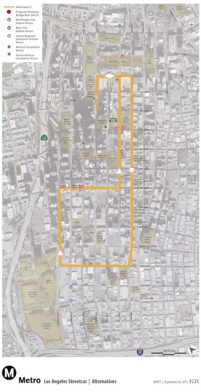 (Yuck.) In any event, I REALLY hope they build east and west tracks on 7th between Hill and Broadway to allow for top-half and bottom-half looping if necessary. |
|
|
|
Post by rubbertoe on Mar 14, 2012 12:43:29 GMT -8
In any event, I REALLY hope they build east and west tracks on 7th between Hill and Broadway to allow for top-half and bottom-half looping if necessary. But wouldn't that create not one, but two JUNCTIONS? Thereby adding Hundreds of Millions of $$$ to the cost and several years of delays getting it working  |
|
|
|
Post by Gokhan on Mar 14, 2012 13:18:44 GMT -8
The problem with the streetcar project is that it's one-way-single-track. Given the one-way-single-track operation, Alternative 7 is the best they could do.
Basically, you can only take the streetcar in one direction. You should take the bus in the other direction, unless you want to loop around many blocks.
|
|
|
|
Post by James Fujita on Mar 14, 2012 23:54:33 GMT -8
Call me crazy, but I don't see the chosen route as all that bad. The one-way operation limits things a little bit, but there's still useful potential in the map.
The most sensible idea would be from the Convention Center to Grand Central Market and back. (Attending Anime Expo at LACC, get a hankering for a torta at GCM). You would hop on near Staples Center, ride up to 4th/ Hill, and get off. Explore the market.
Get on at 4th/ Broadway, ride back to your start point.
And getting up or down Bunker Hill is bidirectional.
|
|
|
|
Post by matthewb on Mar 15, 2012 1:53:50 GMT -8
I definitely see this as a starter line. Ultimately, these tracks could form part of the center of a network extending through downtown and into nearby neighborhoods currently cut off from pedestrians by freeways. 3rd, Beverley, Olympic, and Pico would be some candidates to be connected West of the 110.
|
|
|
|
Post by Dan Wentzel on Mar 15, 2012 9:05:40 GMT -8
In any event, I REALLY hope they build east and west tracks on 7th between Hill and Broadway to allow for top-half and bottom-half looping if necessary. But wouldn't that create not one, but two JUNCTIONS? Thereby adding Hundreds of Millions of $$$ to the cost and several years of delays getting it working There is no need for an "eyeroll". I wasn't aware it would cost that additional amount of money just to fill in the gap. I think it is legitimate to be concerned about the whole line being shut down because of say an auto accident or police activity on one part of the entire line. But I do hope this is a "starter" line that has branches going in other directions. I also believe there will be other parts of the County that will not ever get full fledged light rail (and heavy rail is done it seems when the Purple Line extension is built), and streetcars may become an attractive alternative to those communities. |
|
|
|
Post by rubbertoe on Mar 15, 2012 9:33:22 GMT -8
Dan,
I was just being snarky with the JUNCTION comment due to the recent problems Metro had getting the Expo/Blue junction working.
<snarkiness off>I am 100% behind the streetcar, and your idea of the 7th street East/West connection is spot on, running a lower loop as required. I would imagine that the 7th street bypass would be part of a Phase II upgrade. Since the streetcar tracks are so much easier to lay/connect versus say light rail, you would think that they could build the tracks on 7th, then take a long 4 day weekend and connect the tracks to the rest of the streetcar system. Since the streetcar is operated more like a bus than light rail, I'm imagining that the 2 junctions wouldn't even have any sort of automatic train protection involvement.
I very much look forward to seeing the project progress and develop over time. If they can get Broadway even remotely resembling Old Town Pasadena or Santa Monica, the $125 million will have been well spent indeed...<snarkiness on>
RT
|
|
|
|
Post by Gokhan on Mar 15, 2012 11:38:43 GMT -8
Again, this streetcar should have been double-track. Even back in the past, in the Los Angeles Railway and Pacific Electric days, it was double-track.
I think the only lines that are built one-way-single-track are those nostalgic lines for a touristic fun ride, rather than public transit.
With a one-way-single-track line, how can you ride the line back without losing a lot of time by looping around? You can't. Therefore, it's a one-way trip for most people, using some other form of transit on the way back.
|
|
|
|
Post by rubbertoe on Mar 15, 2012 12:20:02 GMT -8
With a one-way-single-track line, how can you ride the line back without losing a lot of time by looping around? You can't. Therefore, it's a one-way trip for most people, using some other form of transit on the way back. This was discussed previously, but here is an example. Here is the conversation back on the DC Connector board: transittalk.proboards.com/index.cgi?board=connector&action=display&thread=1054&page=3The streetcar intersects with 3 Red Line stations, and 2 DC stations. If the streetcar was 3 miles long and only intersected a single alternate rail stop, you have a good argument that someone would need to ride all the way back around to get back to where they got on the streetcar. But with the connectivity mentioned, you have multiple ways to get back on Metro, specifically the 7th/Metro stop. Here is a prime example: Your destination is a theater on Broadway, assume South of 7th. Coming from either Santa Monica or Pasadena, you would get off at the 2nd street DC station, and jump on the streetcar heading right down Broadway. To get back to where you are going, you take the streetcar to 7th/Metro, then get back on either Blue (Pasadena) or Expo (Santa Monica) to get back. Note that for stops on Broadway South of about 8th street, it is shorter to get to 7th/Metro than it would be to go back up Broadway if the streetcar were double tracked. Thats the benefit of the streetcar having so many connections. And going that way, you just happen to be going right past LA Live, where you can stop off for a quick nightcap prior to getting back on the streetcar for a 3-4 block easy ride back to Metro... For the 3 stops where the streetcar parallels the Red Line, the streetcar isn't as useful in that there are other ways to get to the same destinations faster. I believe the real purpose is to funnel people onto a newly developed Broadway. After all, it was originally conceived to be called the Broadway Streetcar only more recently being advanced by Metro. And, you get to LA Live and Staples along the way back to wherever. I'm not saying that this is the absolute optimum configuration that could have been achieved, but I still like it, and I understand the reasoning behind it. 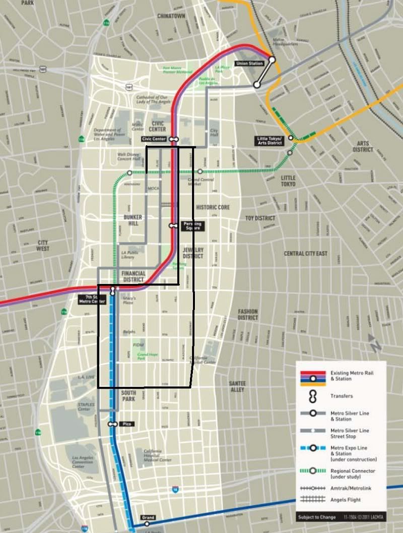 |
|
|
|
Post by rubbertoe on Dec 4, 2012 7:18:46 GMT -8
|
|
|
|
Post by mbbernstein on Dec 4, 2012 10:22:09 GMT -8
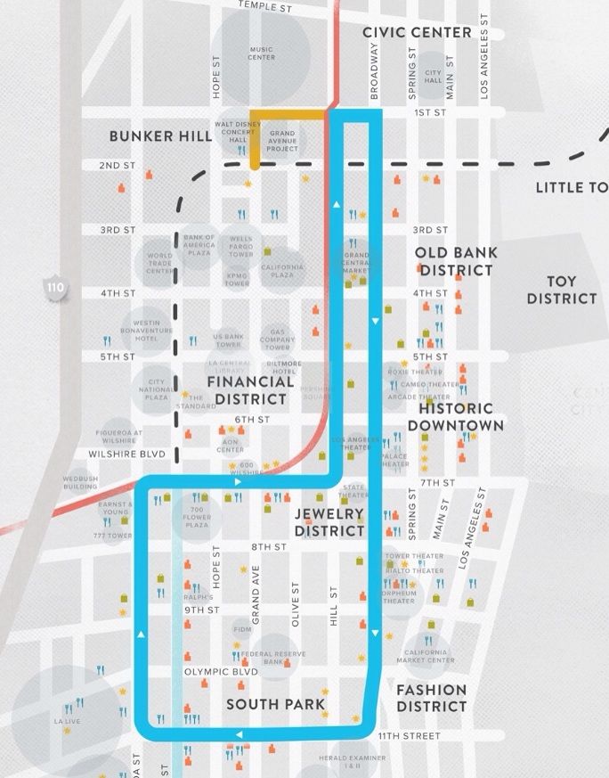
What is that little yellow stub portion of the route near Disney Hall? Also, have the stops/stations been announced for this project yet?
|
|
|
|
Post by LAofAnaheim on Dec 4, 2012 11:00:30 GMT -8
What is that little yellow stub portion of the route near Disney Hall? Also, have the stops/stations been announced for this project yet? No EIR has been completed so that is just a conceptual route. No stations/stops have been announced. |
|
|
|
Post by bzcat on Dec 4, 2012 11:08:02 GMT -8
The stub is illustrated on maps to get support from the Grand Ave developer and secure Bunker Hill property owners tacit agreement to not actively campaign against the project. It will be a nightmare to implement in operation so I'm not exactly sure that it will be build as shown.
As for stops, it will just stop at where buses stop now so there is no mystery... every block from 1st to 11th.
|
|
|
|
Post by gatewaygent on Dec 4, 2012 13:51:36 GMT -8
The stub is illustrated on maps to get support from the Grand Ave developer and secure Bunker Hill property owners tacit agreement to not actively campaign against the project. It will be a nightmare to implement in operation so I'm not exactly sure that it will be build as shown. As for stops, it will just stop at where buses stop now so there is no mystery... every block from 1st to 11th. I imagine that if they lay/run the tracks in the outer lanes, there will have to be a series of bump-outs built for the stops. If it's the inner lanes, then there will need to be a series of new station-islands built. Either way, I'm glad to know this project was approved! |
|
|
|
Post by Dan Wentzel on Dec 5, 2012 12:39:21 GMT -8
 Putting streetcar tracks on 7th Avenue both ways between Hill and Broadway should be the first upgrade to this line. We would have three streetcar routes immediately (A) The full loop we see constructed. (B) A northern loop from Bunker Hill to 7th Avenue (C) A southern loop from 7th Avenue to 11th. This map also makes that need for the 5th Street / Financial District station to eventually be built on the Regional Connector. |
|
|
|
Post by gatewaygent on Dec 6, 2012 14:39:46 GMT -8
I've been blasted for getting ahead of myself and suggesting spurs/extensions into East L.A. and South L.A. And I get that overlapping/overlaying a secondary system with narrow gauge is dubious at best. I just keep picturing a street car that starts at the future Blue/Gold Line Little Tokyo Station and heads south on San Pedro St. into the heart of the Fashion District and then through onto Avalon Bl. all the way to the Green Line Avalon Station. I don't picture droves of people exiting Little Tokyo Station to ride this streetcar to the Green Line or vice versa. But inevitably, some will while others will ride it to the Fashion District or other points in between. The point I'm trying to make is that in providing our tourists with a streetcar for reaching points inside DTLA, it's also important to build something for the locals to get around. I don't know what the residential density is along Avalon Bl., but it seems pretty high.
|
|