|
|
Post by Gokhan on May 16, 2009 14:03:18 GMT -8
This is a blow-up of a speed limit sign on east-bound 1st Street at Clarence Street, between the Mission Street station and the tunnel portal. It clearly says "25", but I can't make out what's in the orange - is it about "school" or "construction"? Since school speed-limit signs are usually yellow and construction signs are usually orange, I would think it's a temporary construction speed-limit sign but I won't bet my money on it. |
|
|
|
Post by erict on May 16, 2009 19:40:19 GMT -8
Speed limits around schools, as far as I know, are always 25mph (as they should be) when there are kids around. I am always shocked by how fast people drive in a school zone.
|
|
|
|
Post by James Fujita on May 16, 2009 21:27:08 GMT -8
here's a construction non-update. I was at Union Station today, on the first leg of a trip to Japan (I fly to the land of the Shinkansen tomorrow), and I had a 30-minute layover. of course, I was curious to see what progress had been made on the extension. (I loved Snuffy's YouTube videos, especially the ones near the Buddhist temple in Little Tokyo, bravo!)
while I was waiting around (on the next platform over) with my camera, a shiny-new Breda train pulled into the station and... proceeded to not continue south. they had blocks on the track. ah phooey.
I haven't had many opportunities to see the construction in person lately, so the videos have been of great interest to me.
of course, given that I only really have time to do any railfanning on Saturdays... will I ever have the chance to see a test train in person?
|
|
|
|
Post by metroman on May 17, 2009 11:00:31 GMT -8
Heavy testing to begin soon...
Metro's filling up 6 Breda cars with 40,000 lbs of weight per car.
Plans are to run two 3 car consists for testing power draw.
The weights will simulate a crush load of passengers.
Nobody seems to know the exact date of testing, but it wll be the last week of this month. But take that with a grain of salt, since plans are always subject to change.
Have your cameras ready.
|
|
|
|
Post by bluelineshawn on May 17, 2009 17:34:00 GMT -8
Good to know, but I live in Carson and have ridden up to the gold line a half dozen times to take pics when the new Breda lrv's were doing something or the other only to find out plans had changed. I'm going to have to rely on Snuffy to get the scoop because I'm not falling for that anymore.  |
|
|
|
Post by bobdavis on May 18, 2009 20:15:23 GMT -8
This morning I checked out the Eastside Extension; the only train I saw was 241 and another Siemens at the west portal of the tunnel. It wasn't moving and the only thing that was moving was a contractor's "hi-railer" truck on the other track. Various bit of finishing-up work were in progress. It looked like full-schedule testing is at least a week away. The signalling system does appear to be working. Most of the stations are nearly done, with station signs and fare machines wrapped up.
|
|
|
|
Post by metroman on May 19, 2009 20:39:27 GMT -8
Good to know, but I live in Carson and have ridden up to the gold line a half dozen times to take pics when the new Breda lrv's were doing something or the other only to find out plans had changed. I'm going to have to rely on Snuffy to get the scoop because I'm not falling for that anymore. I'm not sure if your last sentence is directed at me or not, but I'm not trying to mislead anyone. Just pass on info I receive from the techs in the field. Plans change daily at Metro. Since you have a long drive I'd suggest you wait till next month when it's getting closer to opening. There will be much more activity on the extension as operators and controllers will have to conduct simulated revenue service. Then there will be multiple trains operating. Hope you get some great pics  |
|
|
|
Post by bluelineshawn on May 20, 2009 7:22:35 GMT -8
Of course plans change. That's what I said. I never meant to imply that you were misleading us.
|
|
|
|
Post by bluelineshawn on May 21, 2009 10:31:50 GMT -8
From the service update section of the Metro website: Saturday, May 23, testing of the Gold Line Eastside Extension will begin on May 23. Trains will be running from Sierra Madre Villa to Atlantic, with all passengers exiting the train at Union Station. New train schedules will go into effect on that date. Please see the attached link to view the new schedule. Timetables are also available on Gold Line trains or on the website at www.metro.net.
|
|
|
|
Post by Justin Walker on May 22, 2009 10:16:02 GMT -8
Saturday, May 23, testing of the Gold Line Eastside Extension will begin on May 23. Trains will be running from Sierra Madre Villa to Atlantic, with all passengers exiting the train at Union Station. New train schedules will go into effect on that date. Please see the attached link to view the new schedule. Timetables are also available on Gold Line trains or on the website at www.metro.net.
the timetable they referenced. It's a very silly timetable if you ask me.  Notably, the map in the timetable identifies both the "Metro Gold Line" and the "Edward R. Roybal Metro Gold Line Eastside Extension (Opening mid-2009)." |
|
|
|
Post by Tony Fernandez on May 22, 2009 12:01:47 GMT -8
Or ERRMGLEE for short.
|
|
|
|
Post by wad on May 23, 2009 5:03:09 GMT -8
As Bernard Parks would say, the line just doesn't resonate. |
|
|
|
Post by bluelineshawn on May 24, 2009 16:01:31 GMT -8
Rode the gold line today, was in East LA yesterday. Never saw any trains running through from Union Station continuing to East LA. If it started, it's not that frequent.
|
|
|
|
Post by Transit Coalition on May 24, 2009 17:24:26 GMT -8
Rode the gold line today, was in East LA yesterday. Never saw any trains running through from Union Station continuing to East LA. If it started, it's not that frequent. Most likely, no testing over the holiday weekend. Art Leahy announced several times to the board members at the committee meetings on Wednesday and Thursday, that a June opening didn't seem likely at this point. At the last meeting of the day on Thursday, key rail and construction staff were discussing the failure of some of the critical systems. All the pieces need to work correctly before safety tests can commence. Stay tuned. Tests resume on Tuesday. |
|
|
|
Post by kenalpern on May 24, 2009 18:48:36 GMT -8
If it opens in July, August or even September...it's still opening in 2009!
Not to worry, anyone!
|
|
|
|
Post by bluelineshawn on May 24, 2009 21:15:12 GMT -8
Thanks Bart. And I agree Ken. If there are any bugs that need to be fixed, take care of those first. Open the line when it's ready and not a day earlier.
One thing is that they were supposed to have 14 Breda cars added to the existing fleet in order to have enough cars to open the extension using all 2-car trains. Anyone know how many cars have been accepted and are in service?
|
|
|
|
Post by bobdavis on May 24, 2009 22:52:01 GMT -8
At least eight of the Bredas were in service a few days ago--more Bredas than Siemens units running during midday. The highest number I've seen so far is 726, and I think someone saw 728.
|
|
|
|
Post by bobdavis on May 24, 2009 22:56:19 GMT -8
Also, when I was at LAUS on Friday, the power cables south of the platform still haven't been connected to the overhead. And--welding crews were installing wider emergency steps at the ends of the platform. If they're for emergency use only, what kind of emergency would require wider stairs?
|
|
|
|
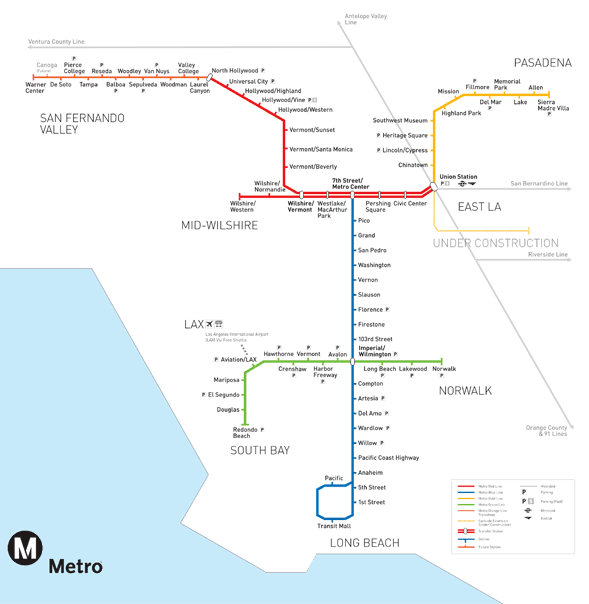
Post by Justin Walker on May 25, 2009 16:11:40 GMT -8
I was at Union Station today and, to my pleasant surprise, I found the following: New Metro Rail System Map (click for larger version):  My version (patched from several pics) (click for larger version):  My thoughts: It's an improvement over the previous system map for several reasons: - Overall better geographic accuracy for customer-orientation (particularly on the Harbor Transitway, Blue Line, and Red Line)
- Inclusion of LAUS-LAX Flyaway Service
- Clarification that El Monte Busway and Metrolink share a station at Cal State LA and NOT in El Monte
- Modest distinction between rail and busway services
- More pleasant appearance without sharp angles along lines
No Silver Line yet, though... |
|
|
|
Post by ieko on May 25, 2009 16:39:27 GMT -8
I really like that map! It's is such a huge improvement, even down at the bottom with the blue line you can see which direction it travels in Long Beach. How cool is that?
I also really like how they use circles and squares to help distinguish busways and rail stations.
Silver Line probably won't start showing up until the end of the year once they figure out what to do with it, so no worries.
|
|
|
|
Post by bluelineshawn on May 25, 2009 21:13:30 GMT -8
I think that map is a huge improvement as well. Although if they are going to be somewhat geographically accurate after Expo opens they will need to better show the blue line heading East at Grand. Then they can show Expo heading South before going West. Although they may just show it directly next to the Harbor Transitway bus line.
|
|
|
|
Post by Jason Saunders on May 25, 2009 21:48:50 GMT -8
Yes, a much nicer map. I like that The Blue Line now has a bend in it instead of a straight line. However, I believe the bend is in the wrong place. The Washington Blvd bend should be after Pico Station (Staples Center) and bend again south after Washington Station.
I also like that Wilshire/Vermont to Civic Center is no longer a straight line. The map can now accommodate a DT connector.
|
|
|
|
Post by darrell on May 25, 2009 22:07:42 GMT -8
My preference is for more geographically-accurate maps, with some overlay of freeways and major boulevards, that better indicate proximity and distance. (Kind of obvious, huh?) They can still be done as simple lines and station dots. Although I suppose they fly in the face of the tradition of stylized subway maps.  |
|
|
|
Post by James Fujita on May 25, 2009 22:35:07 GMT -8
I like the new map. Much less angular than the old maps, and clearly keeping an eye on the future with the possibility of adding the downtown connector and other lines.
As for geographically-accurate maps... they have their place, but there are practical, graphic-design reasons why subway and transit maps throughout the world tend to be somewhat distorted representations. the simpler a map is, the easier it is to look at, especially as a transit system grows (which L.A.'s system will be).
|
|
|
|
Post by metrocenter on May 26, 2009 7:35:51 GMT -8
Real nice job on the map. Except for the incorrectly-placed bend on the Blue Line. Whenever you create a subway map, you will have to find the "right" balance between spatial accuracy and topological clarity. For many decades, the trend has been toward topological clarity, following the example of the famous map of the London Underground. |
|
|
|
Post by joshuanickel on May 26, 2009 18:22:23 GMT -8
I drove along the right-of-way today and I was very impressed that for the first time since this project has begun I personally noticed lots of people working on the project. There were crews block after block, mostly sub-contractors working on Expo particularly from the Fig trench to Crenshaw. Based on bodies on the ground I think that the eleven month gap is going to shrink pretty quick. Finally, Are you talking about the expo line or the gold line? |
|
|
|
Post by bluelineshawn on May 26, 2009 21:13:29 GMT -8
There were at least two trains running in East LA at rush hour today. Both were Siemens P2000's. They were only 1-car each.
Also, there was some visible progress at Soto and Mariachi Plaza from just a few days ago. They are installing more of the topside structures, removing some miscellaneous equipment, and it looked like they started grading. I wouldn't be surprised to see lots of visible progress over the next few days and maybe couple of weeks, including paving and tile work. They had said that this was the last step so the interiot may be essentially finished.
|
|
|
|
Post by metrocenter on May 27, 2009 7:32:00 GMT -8
I spotted several test trains running yesterday evening. Two shots at Indiana Station:   One shot at 3rd/Mednik:  |
|
|
|
Post by bluelineshawn on May 31, 2009 15:36:39 GMT -8
Also, when I was at LAUS on Friday, the power cables south of the platform still haven't been connected to the overhead. And--welding crews were installing wider emergency steps at the ends of the platform. If they're for emergency use only, what kind of emergency would require wider stairs? Everything looks like it's connected now. As for the stairs, I guess that they look at how quickly a large number of people could be evacuated.  |
|
|
|
Post by bobdavis on May 31, 2009 19:45:28 GMT -8
Thanks for the update. Good to see the loose ends (literally!) tied up. Why three feeders would be necessary I have no idea, but one would guess that the engineering calculations called for what appears to be the electrical equivalent of putting ten pounds of feed in a five pound sack.
|
|