|
|
Post by Gokhan on Oct 4, 2010 14:23:18 GMT -8
Expo is hiring new additional staff to help build Phase 2. Negotiations with Casden are now starting on the Expo/Sepulveda Station. I haven't had good feelings about this new Target store and the luxury apartments being built at Sepulveda. They should have never let a rich developer influence the project. Even if Casden pays $13 million, contrary to what is claimed, it won't pay half of the cost of the elevated station. The decision to be made is for grade separation. CPUC will never let an at-grade driveway crossing on Exposition. If they go at-grade, Casden will have to do away with a driveway on Exposition. Casden negotiationsMeeting agenda |
|
|
|
Post by metrocenter on Oct 11, 2010 15:17:31 GMT -8
A new SM Mirror article about efforts in Santa Monica to plan land uses and station areas near the Expo stations in Santa Monica. Planning Gets Detailed on LUCE
posted Oct. 8, 2010, 10:29:00 pm
Katherine Peach / Staff Reporter
The Santa Monica Planning Commission discussed further options and ways to implement the Land Use and Circulation Element (LUCE), the City’s direction and policies for the future of the City of Santa Monica on Wednesday, Oct 7.
LUCE is a culmination of over six years of collaborative work to conserve the scale and character of the city, which touches everything from housing projects, business development, and transportation efforts. In the end, all the different projects within the city are linked together in the overall plan of the LUCE.
All City departments gave input in “excruciating detail” to the LUCE review, said City Planner Eileen Fogarty. Planners worked extensively on the maintenance and engineering aspect of design plans for the future Expo Light Rail.
“We have taken on a Herculean effort to make sure there are no comments that have been missed,” Fogarty said.
The Bergamot Transit Station and the Memorial Park Station are connecting stations in Santa Monica to the light-rail line within dense residential and business areas. The Downtown Station at Fourth Street and Colorado is maximizing public access as well. The plaza designs are of great importance to increase access for users to major hubs such as hospitals and universities.
The City is also considering a redevelopment of the Civic Center in order to incorporate the entire redesign of the downtown area with Palisades Park Garden Walk and Town Square and the addition to the new mall.
Downtown will also focus on increased circulation, zoning development to expand the Lincoln corridor into the downtown area, and bike/street network.
“It’s a monumental job to coordinate the stuff in the pipeline for what the goals are,” said Commissioner Jay P. Johnson. “Each of those projects call out for very specific plans.”
Johnson expressed worry that Development Agreements (DA) that constantly go before the City asking for exceptions from the thorough and strict zoning regulations set by ordinances and reflected in the LUCE.
LUCE is a set of expectations that gives the City the option to ensure DAs will stick to the overall goal in area specific plans, Fogarty explained.
The bike network is also a major focus for the overall transportation goals within the city. The contentious issue of incorporating a bike path into the newly approved Agensys bio-tech company building project failed to gain ground and is still fresh in the minds of all parties.
Staff assured the commission that even with a tremendous increase of development in the city, sustainable transportation options are still a major goal of the Expo stations. Commissioner Hank Koning pushed for a bike path where riders will not have to walk their bike safely and can travel across Olympic Boulevard uninterrupted.
So far there are still no bike paths at the train stations where riders do not have to walk their bikes through the platforms. Staff assured the commission that such plans are still in the works. |
|
|
|
Post by Gokhan on Oct 20, 2010 16:14:07 GMT -8
Update on Phase 2:
The contract documents have now been prepared and given to the two competing teams. The bids are due December 8. The contract will be issued and the project will commence on February 3.
The budget for right-of-way is $200 million. MTA already owns the railroad right-of-way but the Verizon property needs to be purchased for the Expo maintenance facility and property must be purchased for the traction power substations etc. Land prices, despite having fallen somewhat, are still high on the Westside, and the right-of-way acquisitions are still a risk for the project.
There are more than 500 utility conflicts for Phase 2. Colorado Avenue is the biggest problem, where there will be hard to fit the new train utilities as the underground is filled with utilities there and there is lack of space.
Expo Authority is having a difficult time dealing with the City of Santa Monica. They are saying this is because Santa Monica has never had rail transit before (in the modern times) and they are having a hard time getting used to the idea of rail transit.
The speed limit in the final one-mile-long section on Colorado Avenue will be 30 MPH (current street speed limit), and it will be similar to Marmion Way for the Pasadena Gold Line.
|
|
|
|
Post by jeisenbe on Oct 23, 2010 23:51:53 GMT -8
The speed limit in the final one-mile-long section on Colorado Avenue will be 30 MPH (current street speed limit), and it will be similar to Marmion Way for the Pasadena Gold Line. A better comparison might be to the downtown Los Angeles portion of the Blue Line, which runs at about 30 mph max speed, with signals timed for the trains. Compared to a grade-separated route or private right-of-way, 1 mile of 30 mph max speeds will only cost 1 minute of travel time (if the traffic signals are properly managed). |
|
|
|
Post by Gokhan on Oct 24, 2010 10:51:01 GMT -8
The speed limit in the final one-mile-long section on Colorado Avenue will be 30 MPH (current street speed limit), and it will be similar to Marmion Way for the Pasadena Gold Line. A better comparison might be to the downtown Los Angeles portion of the Blue Line, which runs at about 30 mph max speed, with signals timed for the trains. Compared to a grade-separated route or private right-of-way, 1 mile of 30 mph max speeds will only cost 1 minute of travel time (if the traffic signals are properly managed). Yes, I think more importantly than the speed limit, signal priority is critical for these segments. I'm skeptical that Santa Monica will sacrifice signal priority for trains on Colorado. There is signal priority on Marmion Way, isn't there? I think the easiest way to estimate travel time on Colorado is to drive back and forth between 17th and 5th and average the time. Then, one must add another 30 seconds for the 9 MPH speed limit at the sharp curve for pulling to the station. Unfortunately I do expect this one-mile segment to be very slow, probably taking around 5 minutes (including the stations), somewhat like the Downtown Long Beach segment on the Blue Line. Hopefully I will be wrong because it may be frustrating for some passengers to zip through all the way past Exposition/Rodeo and than crawl through the last mile. |
|
|
|
Post by Gokhan on Oct 25, 2010 14:52:03 GMT -8
I strongly agree with this motion of the Palms Neighborhood Council to rename the National/Palms Station simply as the "Palms" Station. This way it becomes a neighborhood station as opposed to an obscure-intersection station:PNC Petitions Expo Line Authority to Name Station “Palms”
Posted on October 24, 2010 by Palms OnlineAt the October PNC Representative Assembly Meeting, the PNC voted to support aresolution that the Expo Line Light Rail Train station stopping on Palms be named “Palms Station”. Here is the complete resolution: The Palms Neighborhood Council petitions the Expo Authority, LACMTA, and the City of Los Angeles to name the intended Expo Line Station at the corner of Palms Blvd. and National Blvd., Palms Station.You might be thinking, what else would the call it? All the planning documents indicate the station name as “Palms/National”; in recognition of the historic nature of the Palms community the PNC feels it is important to ensure the name of the station is just “Palms”. As we plan for this new transit opportunity for residence, the PNC will be asked to comment on art for the station to reflect the uniqueness of our area and we hope the Expo Line Authority agrees to name the station to reflect the community’s desire. Read the full letter to the Expo Line Authority here.
|
|
|
|
Post by metrocenter on Oct 25, 2010 15:09:02 GMT -8
"Palms station"...works for me.
Either that, or name it "Palms/Cheviot station". ;D
|
|
|
|
Post by Gokhan on Oct 25, 2010 15:29:20 GMT -8
"Palms station"...works for me. Either that, or name it "Palms/Cheviot station". ;D Actually the shopping mall by National/Palms that has Vons is called Cheviot Hills Shopping Center and Vons refers to itself as the Cheviot Hills Vons. (See street view here.) In reality it's not Cheviot Hills but Cheviot Hills adjacent. We will certainly call the station "Palms Station," as it is legally in Palms Neighborhood Council boundaries and outside the Cheviot Hills Homeowners' Association boundaries.  This also emphasizes again the point that the stations are usually better named by the neighborhoods, not the intersection names. After all, these are not local bus lines but rail-transit lines with mile-apart stops. |
|
|
|
Post by masonite on Oct 25, 2010 15:48:16 GMT -8
"Palms station"...works for me. Either that, or name it "Palms/Cheviot station". ;D Actually the shopping mall by National/Palms that has Vons is called Cheviot Hills Shopping Center and Vons refers to itself as the Cheviot Hills Vons. (See street view here.) In reality it's not Cheviot Hills but Cheviot Hills adjacent. We will certainly call the station "Palms Station," as it is legally in Palms Neighborhood Council boundaries and outside the Cheviot Hills Homeowners' Association boundaries. First of all, I very much agree with Palms Neighborhood Council. It should be Palms, especially since this is hardly a major intersection anyway. On business naming Cheviot outside the Cheviot boundaries, I think it is pretty common for businesses to try to play off the name of a more wealthy exclusive community. I take my dog to the Brentwood Pet Clinic here in West LA, but it is on Olympic, which is several miles south of Wilshire (the Brentwood border). We are really going to have to rethink some of these station names or it is going to get confusing with the Purple Line extension. We could have Bundy/Expo and Bundy/Wilshire, but I think even that is not the best way to do it. Overall, I believe our stations are going to be seen as more of the center of a more walkable community in the future vs. now. The one that still bothers me beyond belief is Memorial Park on the Gold Line. Why that isn't Old Pasadena and why the merchants there don't throw a fuss to make it so is really beyond me. As the Gold Line expands I bet there is a movement to change that station name. |
|
|
|
Post by metrocenter on Oct 25, 2010 17:47:07 GMT -8
Either that, or name it "Palms/Cheviot station". ;D I wasn't serious. "Palms" makes the most sense. |
|
|
|
Post by Gokhan on Oct 25, 2010 22:22:16 GMT -8
Either that, or name it "Palms/Cheviot station". ;D I wasn't serious. "Palms" makes the most sense. I know. But when Cheviot Hills is mentioned, I must elaborate. Palms Station that is!For historical reference the station was known as Palms Depot in Pacific Electric days and as Grasshopper Station in earlier days, when it was ranch land full with grasshoppers. It was located at Vinton Ave and National Boulevard. Here is the historical map. Palms Depot is now in Heritage Square Museum by the Pasadena Gold Line. |
|
|
|
Post by trackman on Oct 26, 2010 5:22:32 GMT -8
"Palm's Depot" sounds cool to me. Although, generally I don't really care. Perhaps I prefer names that roll off the tongue more easily and that are easily recognizable by the general public. Aren't visitors or intermittent riders going to ask "Where is Palm's?"
|
|
|
|
Post by metrocenter on Oct 26, 2010 7:22:57 GMT -8
Aren't visitors or intermittent riders going to ask "Where is Palm's?" Yes they will. This continues a trend over the last two decades of recognizing the importance of neighborhoods in Los Angeles. In this case, because of the station name, more people will learn where Palms is, and they may decide it is a place they want to visit or live. |
|
|
|
Post by Gokhan on Oct 26, 2010 9:02:57 GMT -8
LOL. If they don't know what Palms is, they have no business there to start with; therefore, it doesn't matter what you call it. Besides, they wouldn't know National/Palms then either.
Moreover, they'd better learn what Palms is if they are going to visit the Westside. It's like coming to Washington DC and not knowing Capitol Hill.
Actually Palms is more commonly known than any of the other neighborhoods around it. For example when there is some TV news, the location is given as Palms but not as Rancho Park or Cheviot Hills. I remember the tragic head-on collision that closed the Santa Monica Freeway for the whole day recently. It had happened at Westwood Boulevard and the news gave the location as Palms. Yes, it's more popular than you think.
Also, search for Palms, California, on any map and you will be directed to the correct location without hesitation. In fact, it does happen to be the most residentially populated neighborhood on the Westside. It's virtually exclusive of apartment buildings -- very unusual for Los Angeles.
Historically, Palms was the oldest town established outside Los Angeles.
Let alone Palms, many people I met in the Los Angeles area don't know where the Westside is. They will ask, "Where is the Westside?" It's the same with Culver City. Many people around here will go blank when you mention the name Culver City.
This is one more reason to build light-rail transit -- so that people can learn about Los Angeles. I didn't know about Boyle Heights before the Gold Line extension myself. I'm guessing it's a well-known neighborhood to many. LOL
|
|
|
|
Post by bzcat on Oct 26, 2010 11:16:47 GMT -8
What is Metro's aversion to naming stations with proper (neighborhood) names?
Now we are going to get stuck with all the "Expo/xxx" nonsense too.
|
|
|
|
Post by LAofAnaheim on Oct 26, 2010 11:30:33 GMT -8
What is Metro's aversion to naming stations with proper (neighborhood) names? Now we are going to get stuck with all the "Expo/xxx" nonsense too. The naming thing is quite a mystery. They did a good job with the Metro Gold Line; which was named more after neighborhoods or points of interest, instead of intersections. However, the other rail lines have that stupid intersection names (outside of downtown LA, Universal City, and NoHo). I like what Palms is doing with their station and I love to see the fact the neighborhood is embracing the station as their iconic status. I also saw in the regional connector recommendation study issued last week that there were many comments to change "2nd/Central" to "Little Tokyo" station...and I think it will happen. We need more people to advocate to Metro to adjust their station names. I put in my 2 cents about 2nd/Hope...that should be called "Bunker Hill". It gives a sense of place a destination. A street corner is just boring. People will more identify with LA's important districts if we adjust the Metro station names. |
|
|
|
Post by metrocenter on Oct 26, 2010 11:56:32 GMT -8
What is Metro's aversion to naming stations with proper (neighborhood) names? Now we are going to get stuck with all the "Expo/xxx" nonsense too. While I agree that neighborhood names are much better than street names, I think Metro's policy -- to default to street names until somebody petitions to change the name -- is for the best. Neighborhood names are a sensitive subject. First off, the city of L.A. is responsible for neighborhood names, not Metro. But even with the city "in charge", sometimes neighborhood names and boundaries are disputed by residents. An example is Valley Village vs. North Hollywood, where there was intense disagreement over the existence of the Valley Village neighborhood and its boundaries. In some cases, a station could arguably be claimed by two or more neighborhoods, and in other cases a neighborhood may have more than one station. A good example is "Vermont/Expo". Metro could call it "West Adams" or "University Park", but is it fair for it to choose one over the other? Also, the name "University Park" could apply to two other stations (also in University Park), and "West Adams" could apply to Western/Expo (also in West Adams): so choosing one of those names could cause confusion. "Vermont/Expo" is a good default, because at least it is unambiguous. Metro is better off choosing a neutral name (cross-streets) at first. They should not be seen as imposing a name on a neighborhood. They are better off listening to local residents and waiting until the surrounding neighborhood asks for a name change. |
|
|
|
Post by metrocenter on Oct 26, 2010 12:00:39 GMT -8
The naming thing is quite a mystery. They did a good job with the Metro Gold Line; which was named more after neighborhoods or points of interest, instead of intersections. Three of the Gold Line stations (Lincoln/Cypress, Heritage Park, Highland Park) were originally named after streets (Avenue 26, French Avenue, Avenue 57). Their names were changed after the fact, by request of the city. Metro has changed names for other stations as well, including Memorial Park, Mariachi Plaza, and the stations on the western end of the Green Line. |
|
|
|
Post by Gokhan on Oct 26, 2010 12:20:17 GMT -8
I would suggest: | Existing name | New name | | Venice/Robertson | Culver Junction | | National/Palms | Palms | | Expo/Westwood | Westwood Gardens | | Expo/Sepulveda | Home Junction | | Expo/Bundy | West Los Angeles | | Olympic/26th | Bergamot | | Colorado/17th | Memorial Park | | Colorado/4th | Santa Monica |
|
|
|
|
Post by Alexis Kasperavičius on Oct 26, 2010 17:48:30 GMT -8
Hey, what about "Sentous" for La Cienega/ Expo? This is the original name after all...
|
|
|
|
Post by Gokhan on Oct 26, 2010 18:52:32 GMT -8
Hey, what about "Sentous" for La Cienega/ Expo? This is the original name after all... Sentous would be a great name for the La Cienega/Jefferson Station, as it accurately describes the location and it can still be found on the maps. I wonder what it was named after. Local historians would know. There was also a Pacific Electric rail yard at Sentous. |
|
|
|
Post by trackman on Oct 26, 2010 19:27:43 GMT -8
What is Metro's aversion to naming stations with proper (neighborhood) names? Now we are going to get stuck with all the "Expo/xxx" nonsense too. While I agree that neighborhood names are much better than street names, I think Metro's policy -- to default to street names until somebody petitions to change the name -- is for the best. Neighborhood names are a sensitive subject. First off, the city of L.A. is responsible for neighborhood names, not Metro. But even with the city "in charge", sometimes neighborhood names and boundaries are disputed by residents. An example is Valley Village vs. North Hollywood, where there was intense disagreement over the existence of the Valley Village neighborhood and its boundaries. In some cases, a station could arguably be claimed by two or more neighborhoods, and in other cases a neighborhood may have more than one station. A good example is "Vermont/Expo". Metro could call it "West Adams" or "University Park", but is it fair for it to choose one over the other? Also, the name "University Park" could apply to two other stations (also in University Park), and "West Adams" could apply to Western/Expo (also in West Adams): so choosing one of those names could cause confusion. "Vermont/Expo" is a good default, because at least it is unambiguous. Metro is better off choosing a neutral name (cross-streets) at first. They should not be seen as imposing a name on a neighborhood. They are better off listening to local residents and waiting until the surrounding neighborhood asks for a name change. I agree with this approach. But, I would also hate to see local residents argue for a particular name with the only intent to legitimize something. |
|
|
|
Post by tobias087 on Oct 26, 2010 19:40:41 GMT -8
I do wish there were a to work "Trousdale" into the USC station name, as it really is quite iconic for the students and workers, and any visitor to the campus, but "Expo Park/USC-Trousdale Station" seems too long, and "USC" and "Expo Park" both seem pretty vital  |
|
|
|
Post by Gokhan on Oct 26, 2010 19:53:23 GMT -8
I do wish there were a to work "Trousdale" into the USC station name, as it really is quite iconic for the students and workers, and any visitor to the campus, but "Expo Park/USC-Trousdale Station" seems too long, and "USC" and "Expo Park" both seem pretty vital I wouldn't worry too much about it. in 1880, when USC was established, Trousdale Parkway was Wesley Avenue with a streetcar on it: 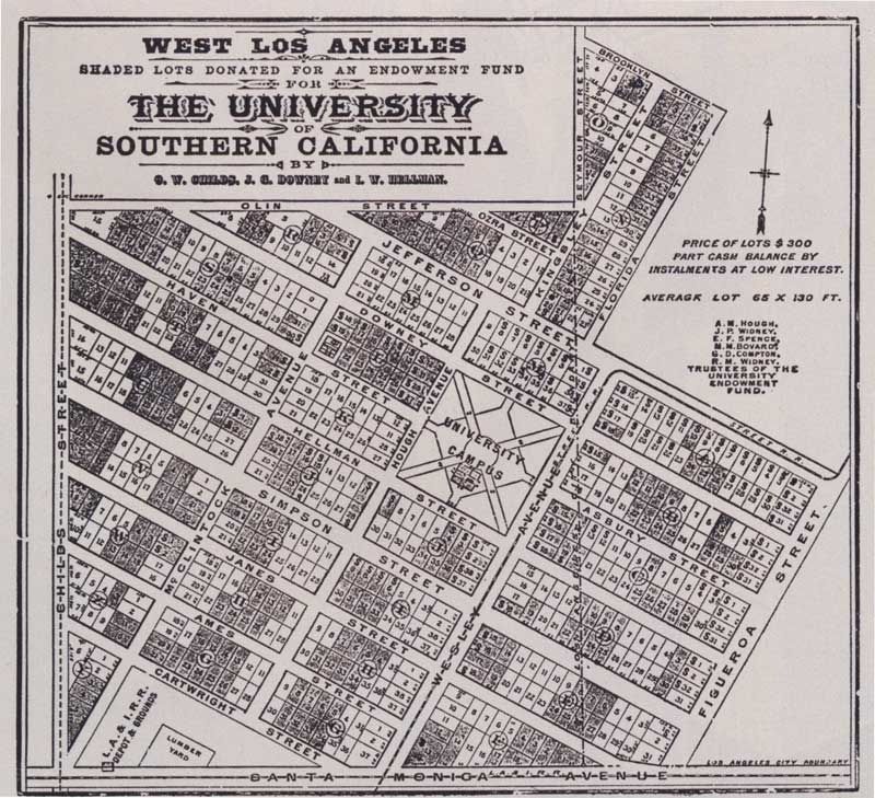 This street was called University Avenue in later years. It was closed to traffic in 1953, the same year when the Air Line passenger service on the Exposition Boulevard right-of-way was discontinued and overhead wires were removed. USC Web site chronology page mentions closing of University Avenue in 1953 but there is no mention of the Air Line. I wonder if they will mention the Expo Line in 2011. In the 50s also the Los Angeles Railway streetcar service was discontinued. Right after the streetcar on McClintock Avenue was discontinued, a large parking lot was built at McClintok/Vermont/Exposition. Browse through the historic aerials: historicaerials.com/ |
|
|
|
Post by metrocenter on Oct 26, 2010 22:05:00 GMT -8
Sentous was a community of French farmers in the 1800's, living to east of what is now Culver City. It was named after Jean Sentous, one of the dairy farmers from France. His name probably refers to Sentous, a small village located in the Pyrenees of southern France.
Another French farmer, Louis Sentous, owned property in Downtown LA. I have no idea if he was related to Jean or had anything to do with the community near La Cienega ("the swamp").
The farmers and the old station are long gone, and I'd be surprised if anyone other than Google Maps refers to it as Sentous in 2010.
|
|
|
|
Post by wad on Oct 27, 2010 3:58:07 GMT -8
Another French farmer, Louis Sentous, owned property in Downtown LA. There's a small Sentous Street at the Convention Center. |
|
|
|
Post by Alexis Kasperavičius on Oct 27, 2010 7:56:18 GMT -8
My 2010 Audi navigation system calls the neighborhood Sentous. Not sure if that legitimizes it, but it is historic. I would vote to call it Sentous. It's a different approach. I like neighborhood names better than street names. When you ask someone where they live, they tell you a neighborhood - as that's an identity. Folks don't use street intersections to describe their home neighborhood. The station stop neighborhood we're discussing is now known as "West Adams," according to the LA times neighborhood project: projects.latimes.com/mapping-la/neighborhoods/neighborhood/west-adams/. I still like Sentous, but doubt anyone would take it seriously. |
|
|
|
Post by metrocenter on Oct 27, 2010 8:30:48 GMT -8
In this case, the LA Times got it completely wrong. "West Adams" is a historic district stretching from Crenshaw east (not west). It includes the neighborhood of "Jefferson Park"West Adams is one of the oldest and most well-established neighborhoods in Los Angeles. The LA Times has no right to rename it as "Adams-Normandie". |
|
|
|
Post by Gokhan on Oct 27, 2010 8:35:17 GMT -8
In this case, the LA Times got it completely wrong. "West Adams" is east of Jefferson Park, not west of it. West Adams is a historic neighborhood and is one of the oldest neighborhoods in Los Angeles. The LA Times has no right to rename it as "Adams-Normandie". LA Times is correct. See zimas.lacity.org/ |
|
|
|
Post by Gokhan on Oct 27, 2010 8:35:55 GMT -8
Sentous was a community of French farmers in the 1800's, living to east of what is now Culver City. It was named after Jean Sentous, one of the dairy farmers from France. His name probably refers to Sentous, a small village located in the Pyrenees of southern France. Another French farmer, Louis Sentous, owned property in Downtown LA. I have no idea if he was related to Jean or had anything to do with the community near La Cienega ("the swamp"). The farmers and the old station are long gone, and I'd be surprised if anyone other than Google Maps refers to it as Sentous in 2010. Reference? |
|


