|
|
Post by erict on Jan 8, 2011 20:16:16 GMT -8
I think the whole minority owned and operated requirement should be eliminated completely.
|
|
|
|
Post by Gokhan on Jan 21, 2011 16:34:15 GMT -8
Some of you were asking about this. I've just found out that the Venice LRT bridge will have a support in the median of Venice Boulevard.
|
|
|
|
Post by Philip on Jan 21, 2011 17:00:01 GMT -8
Some of you were asking about this. I've just found out that the Venice LRT bridge will have a support in the median of Venice Boulevard. Does this mean that is we ever have some kind of rail down Venice, that it would have to go underground to connect to Venice/Robertson? Or would Venice still be wide enough to accommodate at-grade rail there? |
|
|
|
Post by darrell on Jan 21, 2011 17:09:39 GMT -8
Does this mean that is we ever have some kind of rail down Venice, that it would have to go underground to connect to Venice/Robertson? Or would Venice still be wide enough to accommodate at-grade rail there? The whole section of Venice Blvd. from the Ivy Substation east is problematic for at-grade light rail, with the double left turn lanes at Culver and Robertson and tight right-of-way. Don't forget the Phase 2 Draft EIR's Venice alternative elevated this part. The alternative would be to lose a traffic lane in each direction. 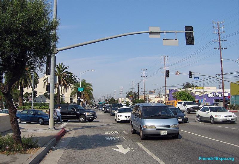 Looking west from the southeast corner of Venice and Culver, Ivy Substation on the left. |
|
|
|
Post by Gokhan on Feb 6, 2011 14:11:44 GMT -8
A lot of important posts are lost but here is a quick summary of the Phase 2 status.
The Skanska/Rados bid came out $100 million cheaper than the URS/Schimmick bid. Skanska/Rados also scored higher in technical qualification.
Skanksa/Rados will be awarded the Phase 2 contract on March 18, and that's when the Phase 2 final design and construction will begin.
On this same date, Expo will approve a master funding and cooperative agreement with Metro for Phase 2.
Maintenance-facility quotes will be received in the next month or so.
Phase 2 Venice LRT bridge will be under a separate contract and potholing will be done this month. Final design has been underway for a few months.
The decision to reject the NFSR petition to stop Phase 2 will be finalized before March 18, which corresponds to the 90-day deadline.
Phase 2 will open to service to Santa Monica in early 2015.
|
|
|
|
Post by Gokhan on Feb 7, 2011 13:17:33 GMT -8
As seen in this picture taken today, the billboards on the Expo right-of-way have now been removed. This is Exposition Boulevard at National/Palms Boulevards: 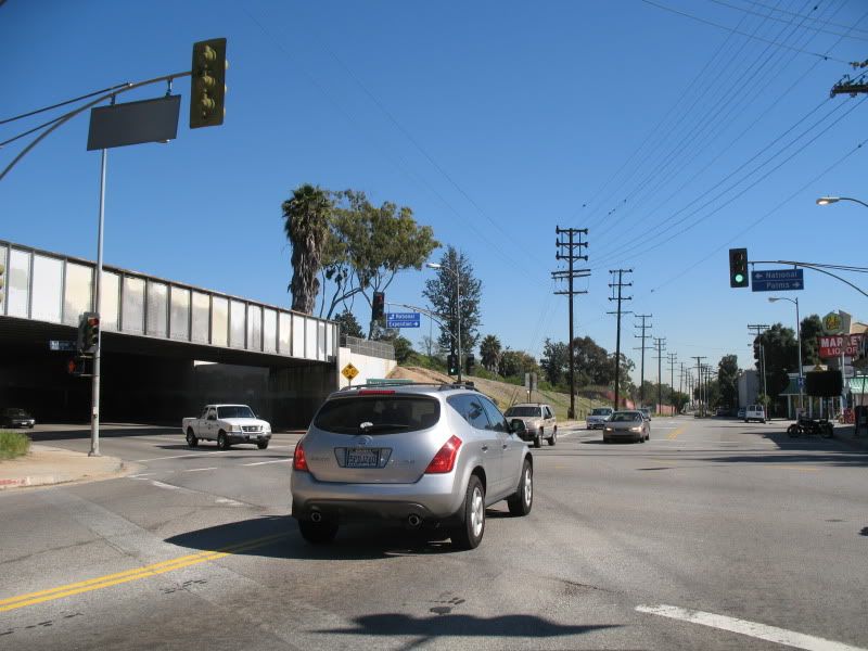 |
|
|
|
Post by bzcat on Feb 7, 2011 17:26:22 GMT -8
As seen in this picture taken today, the billboards on the Expo right-of-way have now been removed. This is Exposition Boulevard at National/Palms Boulevards: I drove by here over the weekend at night and they were working on something next to the freeway with spot lights on. Do we know what they were doing? It wasn't billboard related that's for sure. |
|
|
|
Post by Gokhan on Feb 7, 2011 22:32:52 GMT -8
As seen in this picture taken today, the billboards on the Expo right-of-way have now been removed. This is Exposition Boulevard at National/Palms Boulevards: I drove by here over the weekend at night and they were working on something next to the freeway with spot lights on. Do we know what they were doing? It wasn't billboard related that's for sure. There is a freeway accident-investigation lane behind Price Self-Storage, directly adjacent to the right-of-way. Perhaps you saw something (like a tow truck or a highway-patrol car) in there? Or perhaps they were filming a movie? Or a UFO?  I can't imagine them working on something Expo-related at night so early in the project. |
|
|
|
Post by bzcat on Feb 8, 2011 13:12:13 GMT -8
I was traveling east bound on I-10 so I had a pretty good view of what was going on. It was definitely not on the freeway. The trucks and spot light were parked on the narrow strip of parking lot between the Freeway and National Blvd. Perhaps they were doing something with the tunnel entrance...
|
|
|
|
Post by LAofAnaheim on Feb 8, 2011 13:24:44 GMT -8
I was traveling east bound on I-10 so I had a pretty good view of what was going on. It was definitely not on the freeway. The trucks and spot light were parked on the narrow strip of parking lot between the Freeway and National Blvd. Perhaps they were doing something with the tunnel entrance... They've been working on the National/Overland bridge reconstruction for some time. This is not a new project. Looks to be a freeway/bridge improvement job..unrelated to Expo. |
|
|
|
Post by Gokhan on Feb 8, 2011 14:37:15 GMT -8
I was traveling east bound on I-10 so I had a pretty good view of what was going on. It was definitely not on the freeway. The trucks and spot light were parked on the narrow strip of parking lot between the Freeway and National Blvd. Perhaps they were doing something with the tunnel entrance... The accident-investigation lane is not on the freeway. It's a pocket on the Caltrans easement adjacent to the freeway, between the Expo right-of-way and the freeway. See this Google street view. The tunnel portals and vicinity are not visible from the freeway. The two portals are marked by the easily visible black-letters-on-white "Palms Overhead" signs on the freeway. Palms Overhead is the name of this tunnel, which consists of a reinforced-concrete box structure where the tracks diagonally pass under the freeway. Palms Overhead basically means Palms Tunnel, since the tunnel is located in Palms. The park near its northwest portal is called Palms Park. |
|
|
|
Post by Gokhan on Feb 8, 2011 14:41:28 GMT -8
I was traveling east bound on I-10 so I had a pretty good view of what was going on. It was definitely not on the freeway. The trucks and spot light were parked on the narrow strip of parking lot between the Freeway and National Blvd. Perhaps they were doing something with the tunnel entrance... They've been working on the National/Overland bridge reconstruction for some time. This is not a new project. Looks to be a freeway/bridge improvement job..unrelated to Expo. Yes, they have been widening the Overland Avenue bridge over I-10 on both sides. The east side is completed. The west side is also approaching the completion. I don't think bzcat is referring to that. This project is not near the Expo Line. |
|
|
|
Post by Gokhan on Feb 12, 2011 1:54:40 GMT -8
I was traveling east bound on I-10 so I had a pretty good view of what was going on. It was definitely not on the freeway. The trucks and spot light were parked on the narrow strip of parking lot between the Freeway and National Blvd. Perhaps they were doing something with the tunnel entrance... The accident-investigation lane is not on the freeway. It's a pocket on the Caltrans easement adjacent to the freeway, between the Expo right-of-way and the freeway. See this Google street view. The tunnel portals and vicinity are not visible from the freeway. The two portals are marked by the easily visible black-letters-on-white "Palms Overhead" signs on the freeway. Palms Overhead is the name of this tunnel, which consists of a reinforced-concrete box structure where the tracks diagonally pass under the freeway. Palms Overhead basically means Palms Tunnel, since the tunnel is located in Palms. The park near its northwest portal is called Palms Park. I saw many trucks and construction vehicles parked in the accident-investigation lane on the north side of the freeway at the northwest portal of the Palms Tunnel tonight. This confirms my guess that what bzcat saw last time was also in the accident-investigation lane, though on the south side of the freeway by the Boyscouts and Fitness Equipment facilities next to Price Self-Storage. Since the accident-investigation lane is separated by a fence from the freeway, bzcat mistook it for the Expo right-of-way. What is going on there is simply staging for the Overland Avenue bridge widening or some other freeway work. There was a lot of tagging on the little Palms Tunnel sign for the northwest portal on the north side of the freeway just before the Overland exit. As I said the name in the records for the Palms Tunnel is Palms Overhead and that's what the sign used to say. Now, they put a brand-new sign and the sign says "Palms OH". |
|
|
|
Post by darrell on Feb 15, 2011 15:57:40 GMT -8
Bergamot Area Plan Workshop - Thursday, Feb. 17th [emailed notice]The Planning and Community Development Department invites you to a special Planning Commission workshop on the Bergamot area to help realize the LUCE community vision for an urban transit village enlivened by creative-arts, jobs and amenities, housing, and new walking, bicycling and transit connections. This workshop will be held at Pier 59 Studios located at 2415 Michigan Avenue at Bergamot Station. Please join us on Feb. 17th at 6:30PM to discuss:- THE AREA PLAN: Including the Bergamot Transit Village and Bergamot Art Center
- CREATING AN URBAN TRANSIT VILLAGE: Characteristics of an urban transit village, mix of uses, gathering places, pedestrian-oriented design and scale
- NEW CONNECTIONS: Pedestrian and bike linkages from the village to the Expo Light Rail, Bergamot Arts Center and other destinations to reduce car trips
Your input is needed to create the Guiding Principles for a sustainable transit-focused neighborhood within the Bergamot Area. RSVP to ensure accurate accommodations BergamotPlan@smgov.net or 310.458.8341 Also at www.shapethefuture2025.net/
|
|
|
|
Post by Alexis Kasperavičius on Feb 16, 2011 12:52:32 GMT -8
|
|
|
|
Post by rajacobs on Feb 16, 2011 13:07:50 GMT -8
Just north of Venice (at Robertson), a bulldozer was at work last week moving all piles of gravel and earth from the path of the bridge construction and the tracks that will follow. ...When I see Malcolm return with their drills, I'll really get excited.
|
|
|
|
Post by Alexis Kasperavičius on Feb 23, 2011 8:23:21 GMT -8
Don't know how we missed this from October: PNC Petitions Expo Line Authority to Name Station “Palms”Posted on October 24, 2010 by Palms Online At the October PNC Representative Assembly Meeting, the PNC voted to support aresolution that the Expo Line Light Rail Train station stopping on Palms be named “Palms Station”. Here is the complete resolution: The Palms Neighborhood Council petitions the Expo Authority, LACMTA, and the City of Los Angeles to name the intended Expo Line Station at the corner of Palms Blvd. and National Blvd., Palms Station. palmsla.org/2010/10/pnc-petitions-expo-line-authority-to-name-station-palms/You might be thinking, what else would the call it? All the planning documents indicate the station name as “Palms/National”; in recognition of the historic nature of the Palms community the PNC feels it is important to ensure the name of the station is just “Palms”. As we plan for this new transit opportunity for residence, the PNC will be asked to comment on art for the station to reflect the uniqueness of our area and we hope the Expo Line Authority agrees to name the station to reflect the community’s desire. |
|
|
|
Post by metrocenter on Feb 23, 2011 9:59:45 GMT -8
Don't know how we missed this from October: PNC Petitions Expo Line Authority to Name Station “Palms”The story was not missed, it is just several pages back: I strongly agree with this motion of the Palms Neighborhood Council to rename the National/Palms Station simply as the "Palms" Station. This way it becomes a neighborhood station as opposed to an obscure-intersection station:PNC Petitions Expo Line Authority to Name Station “Palms”
Posted on October 24, 2010 by Palms OnlineAt the October PNC Representative Assembly Meeting, the PNC voted to support aresolution that the Expo Line Light Rail Train station stopping on Palms be named “Palms Station”. Here is the complete resolution: The Palms Neighborhood Council petitions the Expo Authority, LACMTA, and the City of Los Angeles to name the intended Expo Line Station at the corner of Palms Blvd. and National Blvd., Palms Station.You might be thinking, what else would the call it? All the planning documents indicate the station name as “Palms/National”; in recognition of the historic nature of the Palms community the PNC feels it is important to ensure the name of the station is just “Palms”. As we plan for this new transit opportunity for residence, the PNC will be asked to comment on art for the station to reflect the uniqueness of our area and we hope the Expo Line Authority agrees to name the station to reflect the community’s desire. Read the full letter to the Expo Line Authority here. The following is the text from the letter, sent to Gabriela Collins, Government/Community Relations Manager with the Expo Construction Authority: RE: Palms Station on the Expo Line
Ms. Collins:
Per our recent conversations, I am forwarding a copy of the following resolution to you, passed unanimously by the Palms Neighborhood Council:
The Palms Neighborhood Council petitions the Expo Authority, LACMTA, and the City of Los Angeles to name the intended Expo Line Station at the corner of Palms Blvd. and National Blvd., Palms Station.
As I’m sure you know, the Pacific Line Palms Station was an important landmark on the west side of the city, and the community that grew around it is one of the oldest on the west side of Los Angeles. Our stakeholders feel the naming of this new station is not only an important branding opportunity for Palms, but an opportunity for Los Angeles to reinstate a link to the history in one of its oldest and most diverse communities.
It is our desire that our wishes in this matter be made known to all who are involved in the naming of this station. Your assistance in this process is appreciated, and if there are others we should contact directly, your help in identifying those parties would also be appreciated. Thank you for your time and consideration.
Sincerely,
Charles Miller
Overland Residential Representative
Chair, Transportation & Road Works Committee
Palms Neighborhood Council
|
|
|
|
Post by Alexis Kasperavičius on Feb 28, 2011 13:17:22 GMT -8
Big Blue Bus Wants You
By Lookout StaffFebruary 28, 2011 --The Expo line is coming in just a few more years, and the Big Blue Bus company doesn't want to be caught unprepared. The transit company is studying its routes, line-by-busline, to decide how to serve the public more efficiently and how to adapt when the train comes to town. Now Big Blue Bus needs your feedback. It's holding six meetings to discuss some of the changes it's contemplating and to get input from its riders.... www.surfsantamonica.com/ssm_site/the_lookout/news/News-2011/February-2011/02_28_2011_Big_Blue_Bus_Wants_You.html
|
|
|
|
Post by Gokhan on Feb 28, 2011 13:57:13 GMT -8
Big Blue Bus Wants You
By Lookout StaffFebruary 28, 2011 --The Expo line is coming in just a few more years, and the Big Blue Bus company doesn't want to be caught unprepared. The transit company is studying its routes, line-by-busline, to decide how to serve the public more efficiently and how to adapt when the train comes to town. Now Big Blue Bus needs your feedback. It's holding six meetings to discuss some of the changes it's contemplating and to get input from its riders.... www.surfsantamonica.com/ssm_site/the_lookout/news/News-2011/February-2011/02_28_2011_Big_Blue_Bus_Wants_You.html Yes, Paul of Big Blue Bus has been very involved in Expo planning since the draft environmental-impact report stage. |
|
|
|
Post by Gokhan on Feb 28, 2011 14:06:41 GMT -8
One of the arguments against a trench or underground station between Westwood Boulevard and Overland Avenue was that this area is in a 100-year flood zone (a flood occurring every 100 years). After the latest storm, the pictures taken two days ago validate this point. A small pond is formed near the future Westwood Boulevard Station. 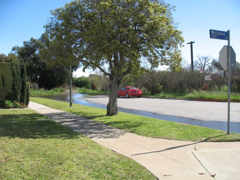 Waves in the pond caused by high winds: 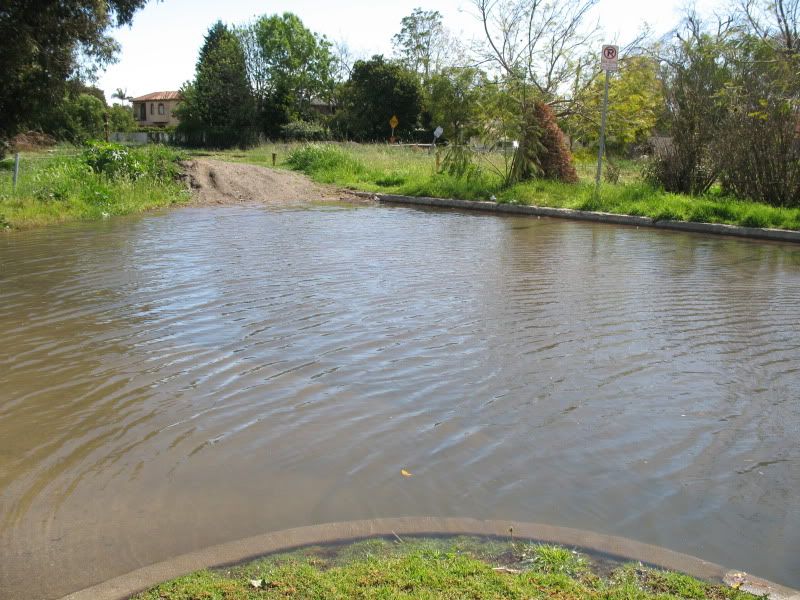 A trench or underground station would require an expensive pumping station to protect the expensive rail investment against a possible major flood in this area. |
|
|
|
Post by jdrcrasher on Feb 28, 2011 20:38:26 GMT -8
Wow, that's almost a foot of water.
|
|
|
|
Post by jamesinclair on Mar 1, 2011 0:07:20 GMT -8
Expensive pumping station? Thats what the contractors want you to think. A much cheaper option is available  "but service is disrupted" For a an even that happens once every 100 years? So? Edit: Hm, the image wont show? www.universalhub.com/files/images/fenwaydam.jpg |
|
|
|
Post by Gokhan on Mar 1, 2011 13:10:22 GMT -8
The construction can now start as early as in 17 days. Although, the contractor will probably take sometime to do the staging. Here is looking west from Venice/Robertson to Palms: 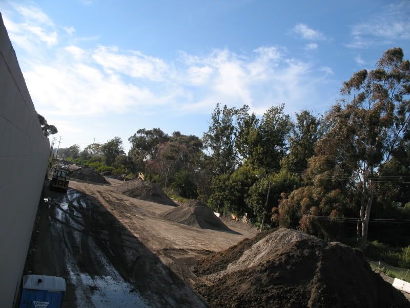 And this is looking east to Venice/Robertson, with the Culver Junction Station in the view. There will be a bridge extending from the station over Venice Boulevard and the tracks will come at-grade near where this photo is taken. There will be an at-grade crossing at Bagley Avenue and an existing bridge (possibly to be replaced) at Exposition/Palms/National, with a station immediately after the bridge on the natural hill there, with access to the center platform from the west side of Exposition/Palms/National: 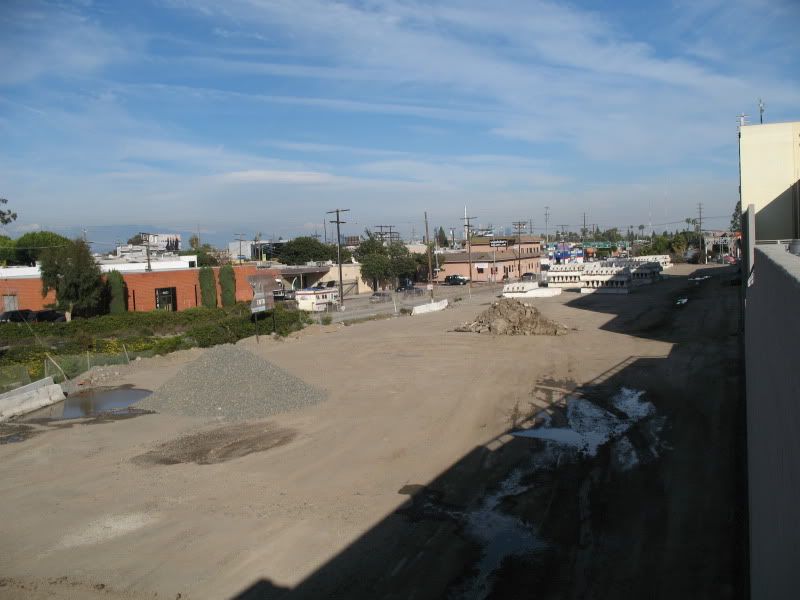 |
|
|
|
Post by Gokhan on Mar 4, 2011 14:24:28 GMT -8
I just found out that an aerial Sepulveda Station would be centered at Sepulveda Boulevard, instead of being offset to the west of the street. This would reduce the station spacing another 300 ft from 0.62 miles to 0.56 miles, which I don't like because it makes the station further away from the dense business district around Pico/Sawtelle, which would have been a better station location from a destination-interest point of view.
|
|
|
|
Post by Gokhan on Mar 4, 2011 18:02:20 GMT -8
Expo Phase 2 will be built by the Skanska/Rados joint venture and the project manager is Skanska's Michael Aparicio. Expo Authority called Skanska "a very good contractor." Michael Aparicio was saying that he would go to every community meeting -- not something we experienced with the Phase 1 contractor. Here is a clipping about the Expo Phase 2 contractor project manager, Mike Aparicio: 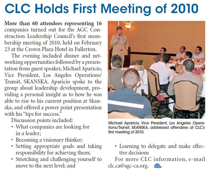 |
|
|
|
Post by Gokhan on Mar 4, 2011 18:36:45 GMT -8
At the March 18 Expo board meeting that will get Phase 2 finally rolling, one of the major options to be decided will be whether to build parking for the Expo/Westwood Station as originally planned (the baseline design) or to omit parking for this station and build a park instead. The cost of the two options for Expo is about the same. (The actual park will have to be built by the city, not Expo.) After studying the renderings at the link below for the two options, cast your vote at this poll! Expo Westwood Station parking and no-parking options renderingsYou can also submit your preference to the Expo Authority or Expo board members if you want it to be officially considered. |
|
|
|
Post by rajacobs on Mar 8, 2011 2:20:56 GMT -8
I hate to say it, but if the renderings accurately portray the soundwalls, the soundwalls make either plan abominable because there is no "reasonable" integration of the ROW with the existing comminity. The Expo plan fulfills the worst fears of those living in the neighborhood--that is will permanently bisect it! I don't think the sounwalls need to be so atrocious--whatever happened to the notion of earthen berms? How about trees?!?
How can we expect anyone living in that neighborhood to welcome the train?
|
|
|
|
Post by Alexis Kasperavičius on Mar 8, 2011 7:17:48 GMT -8
If you lived in Crenshaw, where sound walls are a plenty, and noticed that Cheviot Hills got Disneylandesque earthen berms, might not your next phone call be to Mark Ridley-Thomas? That's 'cause it would be patently unfair.
If Cheviot Hills would have spent their money and energy on working with Expo rather than ceasing all communication and suing them, I am sure a more integrated solution could have been found.
Unfortunately, they acted like spoiled children and this is the result.
The good part, is that over time, as people get fed up with the ugliness of the sound walls, they will likely come up with (and fund) some way to make them more palatable.
Considering the area and the sound wall design, covering them with ivy would be easy and cheap - and look pretty good.
Anything they come up with can also be used as an example for other areas.
See that? It's an opportunity!
|
|
|
|
Post by rajacobs on Mar 8, 2011 11:44:36 GMT -8
I can't fathom why the opposition has been so ugly in attempting to stop the line. The requirement for transit is intuitively obvious. I live at the other end, near the soon-to-be "Palms station" and will look forward to using the line regularly.
But the expo stretch between Overland and Sepulveda has always held a particular fascination for me, imagining how Exposition Boulevard was once fore-shortened to build the Santa Monica Freeway and, long ago tracing the route that Exposition had to follow through the Westside. When I think of the stretch adjacent to the Westwood station, "barrier-filled" and visually-limited, a need for an aesthetic approach, that seems obvious to me, was never even considered. The current myopic residents of that area will be gone or aged before a more visually acceptable solution is even considered with a functional solution already in place.
Sure, NFSR and allies have been far from a "loyal" opposition. Nonetheless, the majority who differ with ther obstructionist legal ploys will be affected by a less than visually-desirable solution. More than the other issues that have been conjured up, I think the sound walls could leave a lasting legacy of ill-will toward the construction. ...Heck those folks west of Overland don't even live in Cheviot Hills!
|
|


 I can't imagine them working on something Expo-related at night so early in the project.

