|
|
Post by metrocenter on Nov 22, 2010 11:28:45 GMT -8
The West Santa Ana Transit Corridor is a project to create a new transit line (possibly light rail) connecting Los Angeles and Orange Counties. The line would use an abandoned rail right-of-way to connect Santa Ana in Orange County to the Green Line in South Gate. A potential extension northwest toward the Blue Line is also being considered. Measure R would provide $240 million to this project, starting in 2015. The project is being coordinated by SCAG, with Metro representing Los Angeles County. The project website is here, and the wiki article is here. SCAG is currently holding a series of six scoping meetings for the corridor:
Paramount
November 16 (Tuesday), 6:30 PM - 8:00 PM
Progress Park Plaza, West Auditorium, 15500 Downey Avenue (map)
Cerritos
November 23 (Tuesday), 6:30 PM - 8:00 PM
Cerritos Park East Community Center, 13234 E. 166th Street (map)
Huntington Park
December 1 (Wednesday), 6:30 PM - 8:00 PM
Huntington Park Community Center, 6925 Salt Lake Street (map)
Garden Grove
December 2 (Thursday), 6:30 PM - 8:00 PM
The Courtyard Center, 12732 Main Street (map)
Cypress
December 7 (Tuesday), 6:30 PM - 8:00 PM
Cypress College, Complex Building, 4th Floor, Room 414, 9200 Valley View Street (map)
Stanton
December 11 (Saturday), 1:00 PM - 3:00 PM
Stanton Community Center, 7800 Katella Avenue (map)
Full info is here. |
|
|
|
Post by bzcat on Nov 22, 2010 12:09:17 GMT -8
Who do we need to contact (twist arm, write strongly worded email, beg) to get him or her to update the forums on this site? It has way too many sub-forums and some of them completely irrelevant. And yet, there is no place to discuss West Santa Ana branch or the 405 Corridor project.
|
|
|
|
Post by metrocenter on Nov 22, 2010 13:38:29 GMT -8
Who do we need to contact (twist arm, write strongly worded email, beg) to get him or her to update the forums on this site? It has way too many sub-forums and some of them completely irrelevant. And yet, there is no place to discuss West Santa Ana branch or the 405 Corridor project. I guess the best way would be to send a message to the admin. I put this project under "Green Line" because it was the closest thing I could find. I agree there are issues with how the forums are set up. I think there should be a separate section for Metro Rail only. And maybe each line should have only one forum, with all related projects together with it. For instance, the Gold Line should have only one forum for all its projects, rather than a forum for each project. |
|
|
|
Post by Gokhan on Nov 22, 2010 15:05:58 GMT -8
This is a really cool right-of-way. It's a razor-straight air line. It's almost completely undeveloped, except perhaps a small section in the Orange County became part of large parking lots.
The final two miles to go east to connect it to the Santa Ana Transportation Center will be a ($) challenge, as the right-of-way terminates at 4th and Raitt, and the streets leading to the Transportation Center from there aren't particularly wide to accommodate light-rail.
After meeting 105/Green Line at 105 & 710, this right-of-way continued north along 105 (Green Line) and then 105 diverged from the right-of-way at Imperial, which continued and connected with the Blue Line at Graham and 106th. But, now, there are six dozen or more houses built in this section of the right-of-way. I wish they had originally connected the Green Line with the Blue Line when it was built. (It would require tearing down those houses.)
|
|
|
|
Post by metrocenter on Nov 22, 2010 16:16:51 GMT -8
^^ Yeah that is a shame that the "Watts connector" was not saved.
This line will either cross the Green Line, or interline with it (only if it is light rail). If it crosses the Green Line, I would guess the intersection would be at/near Garfield Avenue, but this would require a new station at I-105/Garfield. If it interlines with the Green Line, then some new junction would need to be created near the LA River (either east or west of it).
Since the Measure R contribution for this project is capped at $240 million, I wonder how much other money could be raised for this line. If light rail is too costly, they might have to do this as a Metrolink service instead.
|
|
|
|
Post by LAofAnaheim on Nov 22, 2010 17:17:59 GMT -8
Since the Measure R contribution for this project is capped at $240 million, I wonder how much other money could be raised for this line. If light rail is too costly, they might have to do this as a Metrolink service instead. Isn't Bus Rapid Transit one of the design options as well? |
|
|
|
Post by metrocenter on Nov 22, 2010 17:39:22 GMT -8
Since the Measure R contribution for this project is capped at $240 million, I wonder how much other money could be raised for this line. If light rail is too costly, they might have to do this as a Metrolink service instead. Isn't Bus Rapid Transit one of the design options as well? I didn't mention BRT but yes this would be a possibility if LRT is too expensive. At this point, all of the following mode options are being considered: BRT, Streetcar, LRT, DMU, Commuter (Metrolink), HSR. I think streetcar is not realistic (too slow for a 20-mile line), and HSR is not realistic (not cost-effective). |
|
|
|
Post by jdrcrasher on Nov 22, 2010 17:50:06 GMT -8
Another option is for it to cross the green line (possibly with a transfer station) by using the north/south ROW (that goes from Commerce to LB Airport) between Garfield and Paramount Ave. This way it'll go through Paramount, Huntington Park, and Maywood to Union Station (and possibly further to somewhere like, say, Eagle Rock-I think Eagle Rock Blvd is an old ROW). The final two miles to go east to connect it to the Santa Ana Transportation Center will be a ($) challenge, as the right-of-way terminates at 4th and Raitt, and the streets leading to the Transportation Center from there aren't particularly wide to accommodate light-rail. Agreed. To get to the metrolink station, it'll likely have to be below-grade. It's only a couple miles, though. I didn't mention BRT but yes this would be a possibility if LRT is too expensive. All of Measure R's projects are probably gonna need some outside funding to a certain degree. Actually I think the "HSR" option is for it to be a Maglev corridor. Either way, not cost effective given the area needs inner city rail. HRT would've been awesome...  |
|
|
|
Post by metrocenter on Nov 22, 2010 18:27:16 GMT -8
To get to the metrolink station, it'll likely have to be below-grade. It's only a couple miles, though. Or above-grade. All of Measure R's projects are probably gonna need some outside funding to a certain degree. A 20-mile line could easily cost $2 billion or more, based on the cost of other Metro light-rail projects. Getting from $240 million to $2 billion + could be difficult. |
|
|
|
Post by masonite on Nov 22, 2010 22:10:32 GMT -8
To get to the metrolink station, it'll likely have to be below-grade. It's only a couple miles, though. Or above-grade. All of Measure R's projects are probably gonna need some outside funding to a certain degree. A 20-mile line could easily cost $2 billion or more, based on the cost of other Metro light-rail projects. Getting from $240 million to $2 billion + could be difficult. I really don't know what to think of this line at this point. It is great to have a clear ROW and it would be nice to serve that part of the county, but it almost seems like a solution looking for a problem. We'll have Metrolink (with potentially 30 min headways) and theoretically HSR to the corridor just to the East. For $240M, not a whole lot can be built even BRT would be a stretch. Yes, some other money can be matched possibly, but it is really doubtful for a full rail line unless they can get DTC type ridership numbers. I am hoping something can come out of this that won't make it seem like this is just a bone to a section of the County rather than an integral part of the rail network. If we are able to build rail I do hate the fact that we'll have yet another missed connection (Santa Ana transport center). It will be interesting to see what comes out of the Alternative Analysis and environmental studies. |
|
|
|
Post by Gokhan on Nov 22, 2010 22:24:46 GMT -8
Or above-grade. A 20-mile line could easily cost $2 billion or more, based on the cost of other Metro light-rail projects. Getting from $240 million to $2 billion + could be difficult. I really don't know what to think of this line at this point. It is great to have a clear ROW and it would be nice to serve that part of the county, but it almost seems like a solution looking for a problem. We'll have Metrolink (with potentially 30 min headways) and theoretically HSR to the corridor just to the East. For $240M, not a whole lot can be built even BRT would be a stretch. Yes, some other money can be matched possibly, but it is really doubtful for a full rail line unless they can get DTC type ridership numbers. I am hoping something can come out of this that won't make it seem like this is just a bone to a section of the County rather than an integral part of the rail network. If we are able to build rail I do hate the fact that we'll have yet another missed connection (Santa Ana transport center). It will be interesting to see what comes out of the Alternative Analysis and environmental studies. Green Line, which goes from nowhere to nowhere has very good ridership. Since this will extend the Green Line, it's a win - win line. A line going to Orange County is desperately needed. Metrolink, with its long headways and distant station spacings, serves a much different purpose. It's also very expensive for a casual rider. |
|
|
|
Post by jdrcrasher on Nov 23, 2010 8:11:11 GMT -8
The last mile stretch of 4th St (Santa Ana Blvd), between Ross street and the Santa Ana Trans Center isn't wide enough for an elevated structure. Plus, a subway station at Sasscer Park would be awesome. |
|
|
|
Post by metrocenter on Nov 23, 2010 8:58:38 GMT -8
A line going to Orange County is desperately needed. Metrolink, with its long headways and distant station spacings, serves a much different purpose. It's also very expensive for a casual rider. I'm all for this being LRT. I think there is a lot of demand for fast, reliable and frequent transit solution in this part of the region. I have no figures at all, but I have to think the residential density is much higher here than, say, the 60 Freeway corridor. The project will need to raise some serious money for it to happen. However, there are a couple of things to note. First, it will probably be 100% at-grade (or almost 100%), so that should help on the cost front. And on the funding side, this isn't all on Metro: Orange County will be expected to come up with their share. A big question will have to be the station spacing. Fewer stations means lower costs and a faster line. But two few stations could make riding it too inconvenient and thus hurt ridership. The following list of stations is a good starting point for discussion: - Paramount (Rosecrans/Paramount)
- Bellflower (Bellflower/Alondra)
- Cerritos (South/Pioneer)
- Cypress College (Lincoln/Valley View)
- Stanton (Katella/Beach)
- Garden Grove North (Brookhurst/Chapman)
- Garden Grove South (Westminster/Harbor)
- Santa Ana College (Westminster/Bristol)
- Santa Ana RTC (4th/Grand)
A map showing these nine stations is here. |
|
|
|
Post by bzcat on Nov 23, 2010 11:31:28 GMT -8
|
|
|
|
Post by bzcat on Nov 23, 2010 11:48:55 GMT -8
A line going to Orange County is desperately needed. Metrolink, with its long headways and distant station spacings, serves a much different purpose. It's also very expensive for a casual rider. I'm all for this being LRT. I think there is a lot of demand for fast, reliable and frequent transit solution in this part of the region. I have no figures at all, but I have to think the residential density is much higher here than, say, the 60 Freeway corridor. The project will need to raise some serious money for it to happen. However, there are a couple of things to note. First, it will probably be 100% at-grade (or almost 100%), so that should help on the cost front. And on the funding side, this isn't all on Metro: Orange County will be expected to come up with their share. A big question will have to be the station spacing. Fewer stations means lower costs and a faster line. But two few stations could make riding it too inconvenient and thus hurt ridership. The following list of stations is a good starting point for discussion: - Paramount (Rosecrans/Paramount)
- Bellflower (Bellflower/Alondra)
- Cerritos (South/Pioneer)
- Cypress College (Lincoln/Valley View)
- Stanton (Katella/Beach)
- Garden Grove North (Brookhurst/Chapman)
- Garden Grove South (Westminster/Harbor)
- Santa Ana College (Westminster/Bristol)
- Santa Ana RTC (4th/Grand)
A map showing these nine stations is [url=http://maps.google.com/maps/ms?ie=UTF&msa=0&msid= 117650285842102110048.000495bb16b6e15eb0616]here [/url].[/quote] Agree on all points. This line will have very good ridership potential, especially if it is operated as a branch of the Green line OR if it continued to Downtown LA as a separate line. If it is operated as a branch of the Green line (i.e. merge track with Green line just east of LA River and continues to LAX) then all the stations you proposed will work, except the location of the Garden Grove stations. Because Costco parking lot is in the middle of the right of way, the line will need to make a detour on Garden Grove Blvd. Since the train will slow down here, it may make for a better location for the station than Chapman. But it could go either way... Garden Grove could use 2 stations for sure. If the line is designed as a separate line, then we need to add a new station on the Green line at Garfield for transfers. |
|
|
|
Post by metrocenter on Nov 23, 2010 13:39:10 GMT -8
If it is operated as a branch of the Green line (i.e. merge track with Green line just east of LA River and continues to LAX) then all the stations you proposed will work, except the location of the Garden Grove stations. Because Costco parking lot is in the middle of the right of way, the line will need to make a detour on Garden Grove Blvd. Since the train will slow down here, it may make for a better location for the station than Chapman. But it could go either way... Garden Grove could use 2 stations for sure. I'll be honest: I don't know Garden Grove or Santa Ana well at all. So I just picked those last few stations from the map based on well-known street names. Believe me, I would love to see service north of the I-105. That's my old neighborhood. I would probably put stations at: - I-105/Garfield
- Hollydale (Imperial/Garfield)
- South Gate (Firestone/Atlantic)
- Bell (Florence/Salt Lake)
- Huntington Park (Pacific/Randolph)
. |
|
|
|
Post by metrocenter on Nov 23, 2010 15:53:30 GMT -8
Click the image for my updated map: 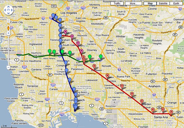 |
|
|
|
Post by bobdavis on Nov 23, 2010 19:00:36 GMT -8
Very interesting--it would tie a short segment of the Pacific Electric Whittier Line to the Santa Ana Line. The observation that the downtown street running in Santa Ana is on a narrow street reminds me of the story that back in the PE days, there were signs along 4th St. (where diagonal parking was used) that warned owners of Packards, Pierce-Arrows and Cadillacs not to park there, because they would be "fouling the main" and were likely to have their luxury rides hit by passing Red Cars.
|
|
|
|
Post by darrell on Nov 23, 2010 21:11:34 GMT -8
I drove the entire right-of-way from Santa Ana to where it now ends at the I-105 freeway / L.A. River eight years ago, a lot of zig-zagging to follow this diagonal route.
The neighboring development is mostly low-density 1950s single-family housing, small shopping centers, and few destinations. Light rail would involve numerous 45-degree-angle grade crossings or the expense of a lot of bridges.
As compelling as this line on the map looks, implementation would be challenging and ridership seems limited.
|
|
|
|
Post by Gokhan on Nov 23, 2010 21:40:52 GMT -8
As compelling as this line on the map looks, implementation would be challenging and ridership seems limited. Given that it will have taken at least 25 years to build it because of the Cheviot Hills opposition, the Expo Line was challenging. This should be a piece of cake.  Regarding lack of destinations, as an example, just recently I had to have the dealer in Cerritos Auto Square drive me for 15 minutes to the Green Line. If this line was up and running, I could have just walked or it would be a 2-minute drive for the dealer. There seems to be a lot of large shopping centers along the line and at least one college. That the line passes through single-family neighborhoods is also the case for the Expo Line almost through the entire alignment, except in Palms. This doesn't mean that the line will have low ridership. I actually think that the diagonal alignment is great because it offers the fastest way to get from Orange County to LA County -- just as we argued for the right-of-way option against the Venice/Sepulveda option in the case of the Expo Line, the hypotenuse of a triangle is shorter than the sum of its perpendicular sides. Build the usual $10-million-a-piece bridges where necessary and quad gates at other diagonal crossings. |
|
|
|
Post by matthewb on Nov 23, 2010 22:28:55 GMT -8
I think a much better first priority should have been to connect the green line to the Norwalk Metrolink station. Once that's done, then a new Orange county line could be built as light rail. For the WSABC to really be useful to the network as a whole, it should definitely continue north to LAUS and not just connect to the green or blue lines. I think we need to extend transit to as many built areas as possible in Orange County and the Inland Empire, but with an eye to how it will fit into the entire network in a reasonable way. We need a combination of intercity and metro rail. Metrolink should function as intercity transit and metro rail should serve more local trips and support sensible urban infill development. Building the WSABC as light rail (my preference) or any other mode (disaster) before connecting the green line to Norwalk/Santa Fe Springs Metrolink via Imperial Hwy. doesn't make sense in terms of prioritising a complete network that will best serve connections between Orange County and LA Metro.
|
|
|
|
Post by Gokhan on Nov 24, 2010 0:22:57 GMT -8
I think a much better first priority should have been to connect the green line to the Norwalk Metrolink station. Once that's done, then a new Orange county line could be built as light rail. For the WSABC to really be useful to the network as a whole, it should definitely continue north to LAUS and not just connect to the green or blue lines. I think we need to extend transit to as many built areas as possible in Orange County and the Inland Empire, but with an eye to how it will fit into the entire network in a reasonable way. We need a combination of intercity and metro rail. Metrolink should function as intercity transit and metro rail should serve more local trips and support sensible urban infill development. Building the WSABC as light rail (my preference) or any other mode (disaster) before connecting the green line to Norwalk/Santa Fe Springs Metrolink via Imperial Hwy. doesn't make sense in terms of prioritising a complete network that will best serve connections between Orange County and LA Metro. Well, right now the priority is the Measure R projects. Metro is required to build this project in some form under the Measure R legal terms. I think almost all of us agree that it should be light-rail and not BRT. As you know the Green Line terminates because 105 terminates. When it's time it wouldn't be too hard to extend the Green Line (not 105) to the Norwalk Metrolink Station. It's only three miles and one can build an elevated line in the middle of Imperial Highway. They would also have to connect it through an elevated section on Studebaker Road, which would be awkward double-L-shaped like the Eastside Line in Little Tokyo with two 90-degree turns. It would require the acquisition of a couple of houses on Studebaker, which shouldn't be a big deal. The line would have to dip under three bridges on Imperial Highway though. So, perhaps, cut-and-cover would be a better option. I'm all for building light- or heavy-rail wherever possible and couldn't care less about which gets built first. |
|
|
|
Post by ieko on Nov 24, 2010 2:05:54 GMT -8
You'd definitely need to tunnel from I-105 to the Metrolink station.
The tracks end below the freeway grade, and the streets are too narrow to support above or at grade light rail.
I'd like a Santa Ana branch even if it didn't go to Union Station. One of the hardest things to do is go to Orange County from western L.A. County. Anything to aide that would be great. I'd like to see something east-west from the South Bay to the Santa Ana Branch too. We have a lot of commuters to and from Orange County via I-405.
|
|
|
|
Post by trackman on Nov 24, 2010 7:58:34 GMT -8
If the Santa Ana line is LRT, it is the northwest end of the line that has my curriosity right now.
I think there is a natural question of how to get potential riders to or from downtown Los Angeles. That question then leads to asking how the Santa Ana line interfaces with Metro's existing system. I don't think it is an easy answer.
By interface, there are two layers. One involves passengers and a possible transfer station. It speaks to convenience. Another is IF the Santa Ana line is to share any tracks with either the Green and/or Blue lines and how that occurs. This second question gets less attention here than the first.
|
|
|
|
Post by metrocenter on Nov 24, 2010 8:19:03 GMT -8
If the Santa Ana line is LRT, it is the northwest end of the line that has my curriosity right now. I think there is a natural question of how to get potential riders to or from downtown Los Angeles. That question then leads to asking how the Santa Ana line interfaces with Metro's existing system. I don't think it is an easy answer. By interface, there are two layers. One involves passengers and a possible transfer station. It speaks to convenience. Another is IF the Santa Ana line is to share any tracks with either the Green and/or Blue lines and how that occurs. This second question gets less attention here than the first. Let me emphasize that the northwest section (north of 105) is not at all settled. The line could head up through Huntington Park as I showed it. Or, it could simply join the Green Line and head west. In either case, riders will have to transfer to get to Downtown L.A. The high-volume Blue and Expo Lines already share track in Downtown: Flower Street does not have the capacity to support another line. So the real issue is: transfer at Imperial/Wilmington or transfer at Slauson? The Green Line branch option would surely be far cheaper and easier, even with the flying junction. But this option would miss some of the most dense and underserved residential areas in the county. This area includes Huntington Park, Bell, South Gate, and Downey. If you ask me, the northwest piece is the most valuable part of the line, in terms of ridership. |
|
|
|
Post by jdrcrasher on Nov 24, 2010 9:49:36 GMT -8
Metrocenter, couldn't it continue on the north-south ROW and then along the river to union station?
|
|
|
|
Post by trackman on Nov 24, 2010 10:10:16 GMT -8
^^^
Metrocenter, you're absolutely correct. Nothing has been settled. The SCAG study has yet to pick a mode, let along figure out how a specific mode would interface with the existing system.
Though, if LRT, how they interface is a curriosity. In no way do I see an easy solution... with trains. There must also be consideration toward capacity of the systems - inside trains and atop tracks. You rightly pointed out the lack of track capacity in downtown LA in a scenario having Santa Ana trains hypothetically continue up the Blue Line.
|
|
|
|
Post by metrocenter on Nov 24, 2010 10:12:42 GMT -8
Metrocenter, couldn't it continue on the north-south ROW and then along the river to union station? It could. The line you are describing would go through several miles of industrial land in Vernon and L.A. Presumably there would be no stops between Florence Avenue and Union Station. This would give the final stretch to Downtown a lot of speed, at the expense of service to Huntington Park. |
|
|
|
Post by masonite on Nov 24, 2010 11:53:29 GMT -8
I have a feeling we are going to need the full 30/10 Plan in place before they even study this and the 405 corridor. Right now, I just don't see a study advocating this for light rail given the money allocated. Something has to change.
$240M??? What did they think they were going to do with $240M here?
This is the problem I have with Measure R. It allocates a certain amount of money for a very specific route, but we have no idea as to how much a project will require. There needs to be some more flexibility. When everything is studied, maybe this project is more valuable than the Eastside Extension #2, but it seems like it would be chaos trying to reallocate things. My big worry is that at the end of the day, we are going to have a bunch of partially built projects (Crenshaw Gap from Expo to Purple, Subway not quite to the Sea) and some really bad ones (Eastside Extension #2). This isn't really the way to build a system.
|
|
|
|
Post by Gokhan on Nov 24, 2010 12:14:24 GMT -8
I have a feeling we are going to need the full 30/10 Plan in place before they even study this and the 405 corridor. Right now, I just don't see a study advocating this for light rail given the money allocated. Something has to change. $240M??? What did they think they were going to do with $240M here? This is the problem I have with Measure R. It allocates a certain amount of money for a very specific route, but we have no idea as to how much a project will require. There needs to be some more flexibility. When everything is studied, maybe this project is more valuable than the Eastside Extension #2, but it seems like it would be chaos trying to reallocate things. My big worry is that at the end of the day, we are going to have a bunch of partially built projects (Crenshaw Gap from Expo to Purple, Subway not quite to the Sea) and some really bad ones (Eastside Extension #2). This isn't really the way to build a system. Measure R and 30/10 plans, including the expenditure plan, were posted at another thread here: Measure R and 30/10 plans |
|


