|
|
Wow!
Mar 24, 2007 16:04:01 GMT -8
Post by Elson on Mar 24, 2007 16:04:01 GMT -8
I just saw this recently...Looks very cool. 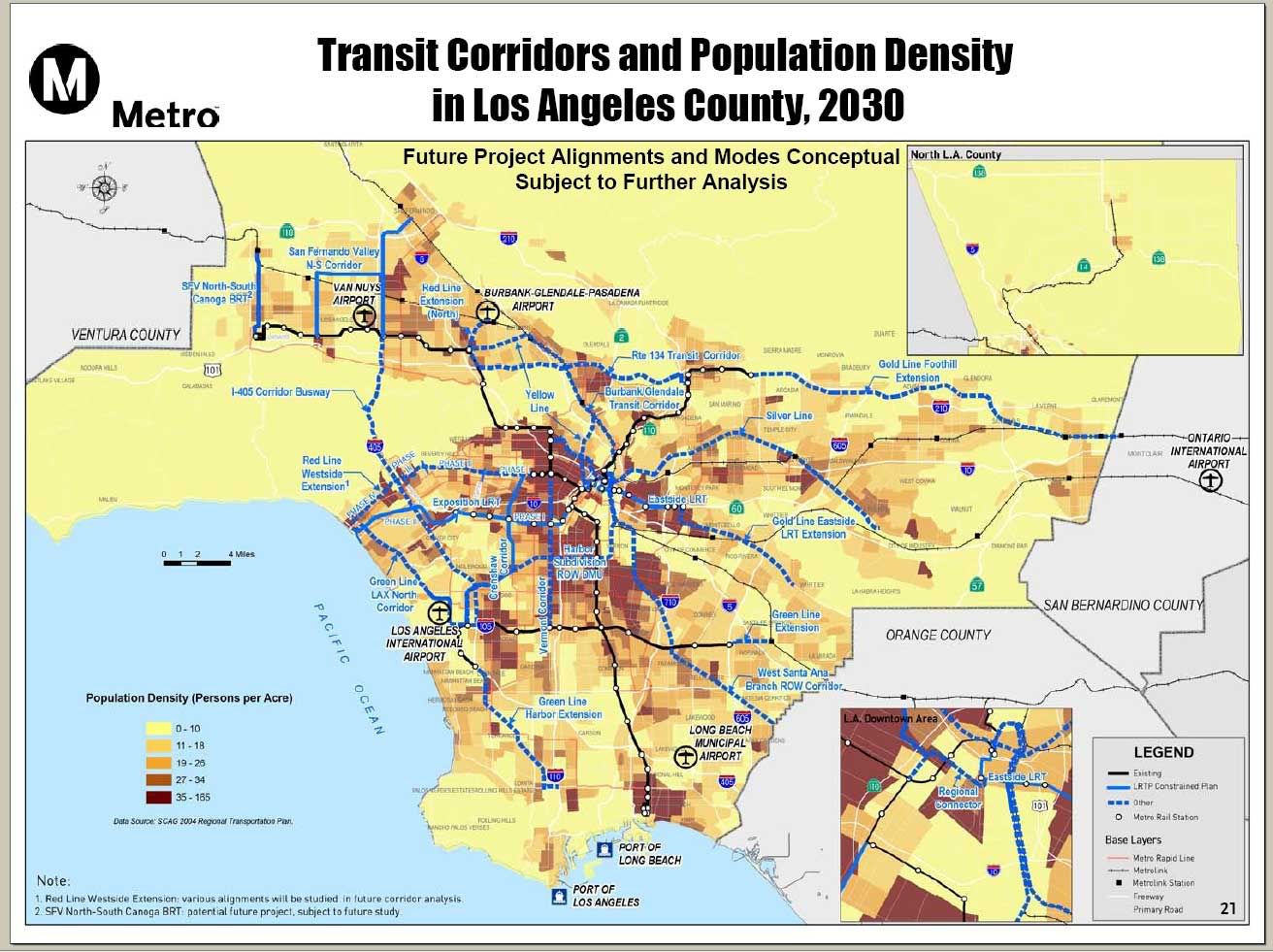 |
|
|
|
Wow!
Mar 24, 2007 19:57:55 GMT -8
Post by kenalpern on Mar 24, 2007 19:57:55 GMT -8
Interesting how comprehensive the map is, and how many of those ideas started and were/are being fought for by the grassroots!
|
|
|
|
Wow!
Mar 24, 2007 21:40:22 GMT -8
Post by whitmanlam on Mar 24, 2007 21:40:22 GMT -8
I wonder why the Green Line Extension doesn't go all the way South to San Pedro.
Did someone forget about San Pedro ?
They already have a trolley ROW.
Otherwise a very comprehensive vision of our possible future !! Two thumbs up !!
|
|
|
|
Wow!
Mar 24, 2007 22:19:41 GMT -8
Post by Justin Walker on Mar 24, 2007 22:19:41 GMT -8
Well, the Green Line "Harbor Extension" shown there uses only Harbor Subdivision ROW. Going to San Pedro would require entirely new ROW, a totally different issue. My observations: Sepulveda Pass is marked with an "I-405 Corridor Busway."  And a much more subtle feature of the map: Expo Phase II on Sepulveda and Venice alignment.  |
|
|
|
Wow!
Mar 24, 2007 22:52:40 GMT -8
Post by whitmanlam on Mar 24, 2007 22:52:40 GMT -8
Yeah, that Expo Phase II goes the long route. Who drew this up, by the way, is it on Metro's official website. This stuff might not be too far off if the funding is right.
It looks like the Foothill Goldline extension doesn't have any density along the way, this could mean some very low future ridership.
|
|
|
|
Wow!
Apr 16, 2007 21:36:17 GMT -8
Post by nickv on Apr 16, 2007 21:36:17 GMT -8
It looks like the Foothill Goldline extension doesn't have any density along the way, this could mean some very low future ridership. Good observation. But I also believe that this extenstion will bring about higher density transit oriented development in this area. I think the areas near Santa Anita Park and Montclair would be good candidates. For starters, the interval between trains probably should be 10-15 minutes during rush hours and maybe 20-30 mintues at other times (I'm just doing some guessing). Down south, NCTD plans to operate the Sprinter LRT with 30 minute headways. Oceanside, Vista, and Escondido are not too high density, yet NCTD has been working on this project since 1987 and has concluded that the area needs LRT which is due to open in December (http://www.gonctd.com/oerail/oerail.html). Obviously there's much more study to be done with the Gold Line segment to determine its headways and productivity. |
|
|
|
Wow!
Apr 16, 2007 22:27:48 GMT -8
Post by whitmanlam on Apr 16, 2007 22:27:48 GMT -8
I think the Cities and County aren't doing enough to encourage Hi-density development near train stations.
They need to build real Hi-density, not those 3 - 4 condos I see everywhere. This is still so suburban.
We need true transit oriented development, like 10 story towers. We need to force Density wherever it can be built.
|
|
|
|
Wow!
Apr 17, 2007 4:41:41 GMT -8
Post by kenalpern on Apr 17, 2007 4:41:41 GMT -8
I agree, Whitman. This map really shows how rail advocates and transit planners have narrowed down the more likely rail/busway extensions for the next 20-30 years. The Silver, Yellow, Lincoln and Green Lines are all there for us to explore, as are the Harbor Subdivision, 405 Busway and Wilshire Subway projects.
Furthermore, this will be an excellent guide to developers as to where they should build, so that they can steer away from where they shouldn't.
Don't worry about the Expo routing--legally, it has to go with the last-approved routing that was approved in 2001. This map will be updated several times in the years to come as rules and decisions change, and as funding and planning efforts proceed forward.
|
|
Mac
Full Member

Posts: 192
|
Wow!
Apr 25, 2007 20:46:15 GMT -8
Post by Mac on Apr 25, 2007 20:46:15 GMT -8
whitman, i do agree that we should have more density, to a certain extent. i would keep the density near busy streets and near stations, but i wouldn't go farther than that. i enjoy having land and space, not just some 3 rooms in a condominium.
Also, another point, is the silver line a HRT? the legend says a dotted line is "other" I don't think that the density there, according to this map, is high enough for an HRT. If the silver line is going to be an HRT, might as well make the eastside an HSR.
btw, where did u get this map elson? sources please.
|
|
unico
New Member
Posts: 7
|
Wow!
Mar 18, 2008 16:45:09 GMT -8
Post by unico on Mar 18, 2008 16:45:09 GMT -8
wow that area east of the blue line seems pretty dense! (being facetious) lets see if they really do that lil santa ana row. a east west route on randolph(east of alameda) and slauson (west of alameda) would make more sense. the tracks are still there from the old PE line after all. one can only hope.
|
|
|
|
Wow!
Mar 18, 2008 23:36:31 GMT -8
Post by Dan Wentzel on Mar 18, 2008 23:36:31 GMT -8
There still needs to be service between Hollywood and Century City via Santa Monica Blvd. The map doesn't have a line there, but does show the density that merits one.
|
|
|
|
Wow!
Mar 19, 2008 13:02:01 GMT -8
Post by damiengoodmon on Mar 19, 2008 13:02:01 GMT -8
The population density map, in addition to the employment density and transit-dependent density maps were really beneficial when putting together Get LA Moving; here's the TTC presentation in 01-07 ( 6.3 MB Powerpoint). Really everyone should start with those and the projected travel speeds to get a very rough idea of where the current and future rapid transit needs are located. |
|
|
|
Wow!
Mar 20, 2008 11:35:24 GMT -8
Post by Dan Wentzel on Mar 20, 2008 11:35:24 GMT -8
While no one is going to agree with anyone 100% of the time, and I don't agree with GLAM's proposed "Silver Line" alignment, I really appreciate the process they used and appreciate the presentation.
|
|
|
|
Wow!
Mar 23, 2008 2:24:37 GMT -8
Post by wad on Mar 23, 2008 2:24:37 GMT -8
There still needs to be service between Hollywood and Century City via Santa Monica Blvd. The map doesn't have a line there, but does show the density that merits one. For both population and ridership. |
|
|
|
Wow!
Mar 23, 2008 2:26:17 GMT -8
Post by wad on Mar 23, 2008 2:26:17 GMT -8
wow that area east of the blue line seems pretty dense! (being facetious) lets see if they really do that lil santa ana row. a east west route on randolph(east of alameda) and slauson (west of alameda) would make more sense. the tracks are still there from the old PE line after all. one can only hope. The tracks are there but the ridership probably isn't. Not every right of way makes a high-ridership rail line, especially if it runs through industrial areas. |
|
unico
New Member
Posts: 7
|
Wow!
Apr 3, 2008 16:11:35 GMT -8
Post by unico on Apr 3, 2008 16:11:35 GMT -8
the ridership is there. look at the map and look at the density in the area. the demographic in this area is mostly poor, very trans dependant, thats why they have a lot of the rapid line. slauson, florence, atlantic. ridership exists already. the only industrial area is vernon otherwise yo are talkin about the some of the densest areas in the state and some of the most park poor areas as well. mixed use corridors would be great. like the orange line, with a bike lane, except make it rail. the ridership def exists.
|
|