|
|
Post by Dan Wentzel on Feb 27, 2008 13:10:01 GMT -8
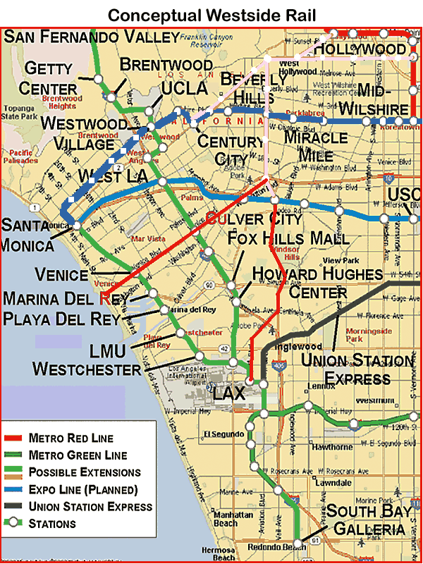 What if the line went to the Miracle Mile? If Alternative 9 were built, the trains would go directly to Century City, but what about all of those people who live in the SFV and work in the Miracle Mile? Wouldn't a line straight down La Cienega from Hollywood/Highland please everyone? I would be very happy with that. As long as the line serves Santa Monica Blvd. between La Cienega and Fairfax, I think how it links up with the Red and Purple Line has lots of possibilities. I would agree with serving the Beverly Center/Cedar Sinai instead of the back end of Beverly Hills, with the Pink Line rejoining the Purple Line at La Cienega/Wilshire (or continuing down to the Expo Line on La Cienega and potentially the airport too. If the Red-Line is extended to the Burbank Airport, we could potentially having the Pink Line going airport to airport. Two airports on one line!) The biggest sell of Alternative #9 is directly connecting the Valley and the Westside via Santa Monica Blvd. A one-seat ride from the Valley to Century City is a major selling point. What Alternative #9 is move to a larger discussion of just serving the Westside west of Hollywood/Highland or Wilshire/Western, which is 100% valuable in itself, but serving the needs of people regionally travelling to/from the Valley and to/from the Westside. Once the MTA Commits to that, I think serving La Cienega over the back end of Beverly Hills makes a lot of sense. If you see the Pink Line alternatives map I posted, SantaMonica/La Cienega to Wilshire, then Expo, then to LAX is one of the alternatives. |
|
|
|
Post by Tony Fernandez on Feb 27, 2008 13:14:47 GMT -8
I really like the line that goes straight to Culver City down to Sepulveda. Seems great to me. A little far off, but a great idea nonetheless. The only change that I would make is that I would end it at Sepulveda. Going all the way to Venice seems unnecessary given how expensive HRT is.
It's a shame that La Cienega is not on the list for Metro's Westside Extension. Ever since jlrobe pointed it out on SSC, I've been convinced that this would be much better than a Santa Monica alignment. It would be shorter, serve more destinations, and require less stations. In all aspects it seems more efficient.
|
|
|
|
Post by Dan Wentzel on Feb 27, 2008 13:38:54 GMT -8
LaCienega to Santa Monica and over makes sense to me.
LaCienega to Sunset and over does not.
The fact the MTA is even still discussing Santa Monica Blvd. is a possible alignment is more than I'm sure they were expecting.
If we don't keep pushing, the MTA will pat Santa Monica Blvd. supporters on the head and go away, with no heavy or light rail, no streetcar, not even a rush hour, bus-only lane.
As Jody Litvak of the MTA stated in City Beat, they were surprised by the amount of support for going southwest from Hollywood/Highland.
It is my hope as an advocate, they will continue to be surprised by ever increasing support.
But, I'd be an enthusiastic part of any coalition that travels east/west on Santa Monica then north/south on La Cienega.
|
|
|
|
Post by Dan Wentzel on Mar 13, 2008 9:45:36 GMT -8
Here's a link to a great blog post from "Ditch the Car, Take the Metro." Three-Hub PlanHe described graphically what I've been trying to explain about the "transit triangle" formed by the Red, Purple, and "Pink" Lines. I also like that he uses the term "Pink Line" for the Santa Monica Blvd. alignment, meaning "Pink Line" is catchy. Now if we can only get the MTA to use the term "Pink Line" the way they've referred to the "Silver Line". 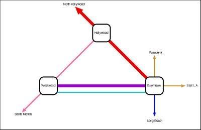 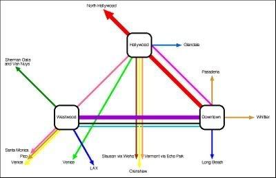 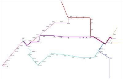 |
|
|
|
Post by JerardWright on Mar 23, 2008 7:48:07 GMT -8
I would agree with serving the Beverly Center/Cedar Sinai instead of the back end of Beverly Hills, with the Pink Line rejoining the Purple Line at La Cienega/Wilshire  Why not just route the Purple Line up to Beverly Center/Cedars Sinai and reduce the construction altogether along La Cienega Blvd and just route the Santa Monica Blvd piece to meet up at Cedars/Beverly and continue as a two branch HRT west down to Westwood. The La Cienega corridor south of Wilshire would duplicate what is being done with the Crenshaw Corridor and La Cienega Corridor doesn't have the density compared to Crenshaw Corridor. I hate to be the grim reaper of transit planning but that one seat ride isn't going to happen from the Valley to Century City off that configuration more than likely a transfer will have to be made at Hollywood/Highland because the planners/builders didn't anticipate a Santa Monica Blvd alignment in their plans. Which means in order to build that we would have to delay operations of the existing subway of upwards of 3-4 years to build the tie-in. |
|
|
|
Post by rayinla on Mar 23, 2008 13:39:34 GMT -8
Isn't there a gigantic storm sewer running directly under San Vicente? Wouldn't that be problematic (engineering-wise)?
|
|
|
|
Post by JerardWright on Mar 23, 2008 16:15:48 GMT -8
It's a pipeline that to my knowledge is on one side of San Vicente which is a wide street.
|
|
|
|
Post by Dan Wentzel on Mar 25, 2008 13:58:10 GMT -8
I hate to be the grim reaper of transit planning but that one seat ride isn't going to happen from the Valley to Century City off that configuration more than likely a transfer will have to be made at Hollywood/Highland because the planners/builders didn't anticipate a Santa Monica Blvd alignment in their plans. Which means in order to build that we would have to delay operations of the existing subway of upwards of 3-4 years to build the tie-in. The map is nice, but it mistakenly uses Sunset instead of Santa Monica.  Here is Alternative #16 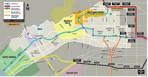 If an LRT transfer at H/H is chosen, I'd prefer that at Santa Monica/La Cienega or Santa Monica/San Vicente it head to down La Cienega to the Expo Line for transfers and possible track sharing. There is also the long-way around option for the Northern route of the Crenshaw line crossing on San Vicente from Expo to Santa Monica and then cutting over which I've seen as well. In that event, the Pink Line would be the northern crosstown extension of the Crenshaw Line for those heading north and northwest instead of downtown. 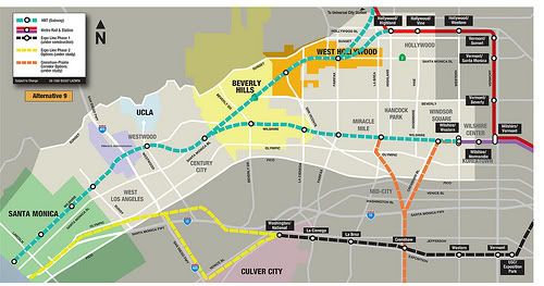 In any event, Alternative #9 shows the direct Valley line skipping H/H and going to Santa Monica/Fairfax from Universal City. Maybe they can put a stop at Sunset/La Brea and skip H/H entirely to start with to make the Sunset Blvd. advocates happy with a stop there. Heading northeast, if the Pink Line went from Santa Monica/La Cienega and then to Fairfax/Santa Monica and then to LaBrea/Santa Monica and then headed northward the tracks meet the Hollywood/Highland station from the other end couldn't it? I'm not sure why the station would even have to be closed. We'd be building new tunnels and tracks, but not a new station. Both the Red and Pink Lines would be using the northbound track at H/H and both the Red and Pink Lines would be using the southbound track at H/H as well. Heading south from the Valley, after Hollywood/Highland, the Red Line could head towards Vine and the Pink Line could then break south to La Brea / Santa Monica, then head west to La Cienega before either continuing directly to Century City or heading down to Wilshire. |
|
|
|
Post by JerardWright on Mar 26, 2008 10:17:49 GMT -8
The map is nice, but it mistakenly uses Sunset instead of Santa Monica.  That map is what I used in the October scoping letter, but there are things to understand between Sunset and Santa Monica Blvds. If we're looking at the entire end to end corridor from West LA to Downtown via Echo Park, Hollywood, West Hollywood and Century City then Santa Monica Blvd is clearly the perfect alignment BUT if the segment in question is much smaller between West Hollywood to Hollywood then Sunset is a much stronger alignment. It is all based upon how much of the corridor segment we're using. That is correct considering that there will be two opportunities to make a transfer into Downtown LA with either the Purple Line or Expo. Depending on how far west the transfer to the Purple Line is (either Wilshre/La Brea or Wilshire/Fairfax) it makes a difference on the intended transfer direction, La Brea makes it so that it's possible to take roughly the same amount of time to reach Downtown as Expo would. How are you going to share tracks without closing the tunnels and station to adjust the track signalling which will be needed to ensure the trains don't crash into one another most of which will require closing of the station platforms to build the right train clearences and track curvature. This little piece can add a considerable amount to the cost of the project, because provisions were not made in the first construction of the project to do this so that these things can be built easier in the future. This could be done very, very slowly on weekend evenings with work boring through the existing tunnels and ensuring that the tunnel structures are supported through the new connection because we are in a seismic zone. |
|
|
|
Post by Dan Wentzel on Mar 26, 2008 10:58:56 GMT -8
That map is what I used in the October scoping letter, but there are things to understand between Sunset and Santa Monica Blvds. If we're looking at the entire end to end corridor from West LA to Downtown via Echo Park, Hollywood, West Hollywood and Century City then Santa Monica Blvd is clearly the perfect alignment BUT if the segment in question is much smaller between West Hollywood to Hollywood then Sunset is a much stronger alignment. It is all based upon how much of the corridor segment we're using. Would you explain your reasoning? Bus ridership on the 4/704 is much heavier wester of Vermont and even La Brea on Santa Monica than anything on Sunset Blvd. which cannot even support an all day express bus. More pedestrians can walk to a Santa Monica rail by far than can walk to Sunset, and Santa Monica Blvd. is where the locals want it. The case for Sunset has mostly been based on "if" enough development is eventually allowed there (and there won't be), Sunset will become as highly an appropriate rail corridor as Santa Monica, and assuming there won't be further development on Santa Monica (and there will be). Politically, Santa Monica Blvd. will also be an easier "sell". Fortunately, the MTA recognizes that Sunset is much weaker corridor than Santa Monica and has not included it in its Alternatives west of Fairfax. As I've said in earlier posts, should we ever get to the point where this argument is more than academic, there will be a healthy competition between Santa Monica Blvd. advocates and Sunset Blvd. advocates. My group will be larger and have more backing, but I look forward to the debates. I'm sure both sides have the best interests of the region and the locality in mind and are both well-intended. The most likely compromise that will make no one happy is that Sunset will get a stop the La Brea and Santa Monica will get the stops on La Cienega and San Vicente. The big fight will be over Fairfax unless the rail line goes straight up Fairfax. There is no political way the "Sunset Strip West" stop will happen (nor should it). It would come at a total cost of a east/west ride on SMB and the City of West Hollywood, where that stop is located, will fight it for a SMB location instead. |
|
|
|
Post by JerardWright on Mar 26, 2008 12:42:51 GMT -8
That map is what I used in the October scoping letter, but there are things to understand between Sunset and Santa Monica Blvds. If we're looking at the entire end to end corridor from West LA to Downtown via Echo Park, Hollywood, West Hollywood and Century City then Santa Monica Blvd is clearly the perfect alignment BUT if the segment in question is much smaller between West Hollywood to Hollywood then Sunset is a much stronger alignment. It is all based upon how much of the corridor segment we're using. Would you explain your reasoning? Bus ridership on the 4/704 is much heavier wester of Vermont and even La Brea on Santa Monica than anything on Sunset Blvd. which cannot even support an all day express bus. More pedestrians can walk to a Santa Monica rail by far than can walk to Sunset, and Santa Monica Blvd. is where the locals want it. The case for Sunset has mostly been based on "if" enough development is eventually allowed there (and there won't be), Sunset will become as highly an appropriate rail corridor as Santa Monica, and assuming there won't be further development on Santa Monica (and there will be). Read what I wrote again, and you'll see the point. It's based on regional scale. If the impact area is much longer from West LA to Downtown, then Santa Monica Blvd is the right route,. If the impact area is smaller and more specific than it's Sunset. Notice that between Hollywood and West Hollywood, the #2 bus has a greater density of ridership in that ONE segment, but not for the entire corridor end to end. Why is that maybe it's because it's so close to the Red Line corridor which already exists. I know it will be larger, please go back and read my previous post where I highlight the spots Santa Monica Blvd CORRIDOR will connect with as to why it will be larger, but don't neglect the fact that in this small section of Sunset between La Brea and San Vicente has just as much development potential with existing density in place. Again in the end of the day this is all based on what the corridor is trying to serve and from where and will it use exisiting infrastructure or have to build a new one. |
|
|
|
Post by Dan Wentzel on Mar 26, 2008 13:36:58 GMT -8
I've read your post in its entirety. I certainly respect what you wrote. I just don't agree with it. The key word in your sentence is "potential". Again, the entire Sunset Blvd. argument is based on an utterly unrealistic assumption of how much "potential" development the NIMBYs up there that will allow on Sunset for it to draw even with Santa Monica Blvd. in merit as a transit corridor, ignoring the fact that while Sunset development is growing, so will SMB's development. West of La Brea, Santa Monica is far more pedestrian friendly because of the incline required to access Sunset. The potential ridership in that area will cry for it to be on SMB, not Sunset. Look at the density map on the WOW thread. There is far more density closer to Santa Monica Blvd. than Sunset. If both boulevards increase density, Santa Monica is still going to be the greater corridor. And that's why SMB will win likely win the way, even for an Alternative like #16. Even this I don't agree with. I ride these lines frequently. There is no way the total #2 bus ridership has more ridership between LaBrea and San Vicente and the 4/704 riders between LaBrea and San Vicente. The compromise, which I don't support, but will probably have to live with, which is still better than nothing, is Sunset Blvd. getting La Brea and Fairfax and Santa Monica Blvd. rightfully getting La Cienega and San Vicente, and hipsters who want to go to their nightclubs on Sunset on the western strip either getting on a bus or staying home. Which takes us back to the original map the MTA circulated before the Alternatives Analysis. 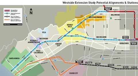 In any case, back to coalition building for the Pink Line. It is my great hope that this discussion becomes more than academic. |
|
|
|
Post by Dan Wentzel on Mar 27, 2008 10:41:31 GMT -8
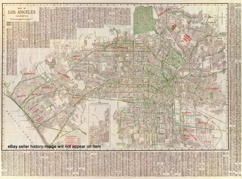 Here's a 1928 map. Look at what we've lost due to 50 years of social engineering in favor of the car culture. Think of what we can get back. Notice the beautiful, historical Santa Monica Blvd. rail alignment, (also the alignment of famous Route 66). In particular, notice the diagonal ROW from Fairfax/Santa Monica that would allow for a direct connection to Hollywood today.  May past become present and future. |
|
|
|
Post by JerardWright on Mar 27, 2008 13:03:21 GMT -8
I've read your post in its entirety. I certainly respect what you wrote. I just don't agree with it. That's fine, I can live with that. ;D Likewise Santa Monica Blvd potential is also unrealistic for the exact reasons you're claming for Sunset. This again goes back to the central question as to how this will be done and what are we trying to connect? Is it an entire 10-15 mile regional corridor or a segment within a subregion to connect between two regional corridors? That logic makes no sense, if it's not pedestrian friendly to access Sunset from Santa Monica, the inverse is true from accessing it fom Sunset to Santa Monica. What scale is that map on, it makes a big difference to the density. So the potential is the exact same for both corridors. Well I'll let you get in touch with the Operations Manager of the Westside and he can give you those numbers. You'll be surprised. Look on a #2 schedule, has it ever occured to you why the bulk of those trips end in West Hollywood? Likewise. |
|
|
|
Post by Dan Wentzel on Mar 27, 2008 15:04:52 GMT -8
No, it makes perfect sense, because more people will be able to walk to Santa Monica west of Fairfax from both north and south because of that incline, than will be able to walk to Sunset. Like Damien Goodman and I said, we will have to agree to disagree.  All of us have the best of intentions in this. The Sunset advocates want rail from LaBrea all the way to San Vicente. The Santa Monica advocates want rail all the way from LaBrea to SanVicente. Since both cases would allow for a stop at San Vincente and Santa Monica, the real fight will be Fairfax and La Cienega. The likeliest result will be splitting the two and giving Fairfax to Sunset Blvd. and La Cienega to Santa Monica and skipping the western strip entirely because WeHo, where it lies, doesn't it want it there, and wants it on SMB. Maybe once the Pink Line is finished with stops on SMB at La Cienega and San Vicente, we can create some cute little streetcar to take people up to the western strip on Holloway. Now back to work on the Pink Line, the Santa Monica Blvd. alignment.  |
|
|
|
Post by Dan Wentzel on Apr 6, 2008 14:17:34 GMT -8
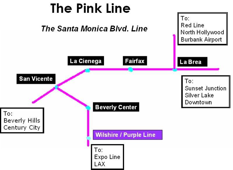 Here's another map of The Pink Line I have created. I would certainly love riding from Century City to North Hollywood on a one seat ride.  It also unites West Hollywood and Silver Lake, Southern California's two principle gay neighborhoods. And, it restores an important rail corridor that helped build L.A. Let the good times roll! |
|
|
|
Post by Tony Fernandez on Apr 6, 2008 21:46:41 GMT -8
It still isn't clear to me that Santa Monica Boulevard should be built on. One side of the street is great, the other is just full of potential NIMBYs.
|
|
|
|
Post by Dan Wentzel on Apr 7, 2008 5:59:43 GMT -8
Well, there are potential and real NIMBYs on Wilshire now and even more potential NIMBYs up on Sunset, and there are NIMBYs on every real and potential corridor in this city. If we let the NIMBYs dictate where there'd be rail, we wouldn't have any. Oh, that's right. Southern California did. I have no doubt there won't be NIMBYs for every single project the MTA proposes, from automobile-entitlement folks, people still living in Sam Yorty's L.A. and bus-only transit extremists, not to mention the anti-tax people who still mistakenly see building roads as a non-subsidy and transit lines as subsidy. The most potential NIMBYs for the Pink Line are in Beverly Hills, but if after San Vicente/Santa Monica, if the line joins La Cienega and then joins up with the Purple Line on Wilshire toward Century City, that's certainly a fine alternative. Even if that adds a couple of minutes to the ride, it is still light years ahead of snaking through the canyons and passes and on SMB during rush hour. But, like the Friends of the Expo Line who formed a grass roots effort to get the project started, the advocacy effort has begun. For those interested, I've created a Facebook group and a MySpace group for the Friends of the Pink Line. Friends of the Pink Line - Facebook pageFriends of the Pink Line - MySpace pageI've also created a blog to track progress for the Pink Line: Ride the Pink Line |
|
|
|
Post by Dan Wentzel on Apr 21, 2008 11:21:49 GMT -8
I really recommend Jon Von Kerczek's " Ditch the Car, Take the Metro" blog. Whether one agrees or not with all his conclusions, I really appreciate the thoughtfulness he puts into his blogs. He is also a very big supporter of the Pink Line. |
|
|
|
Post by Dan Wentzel on May 6, 2008 8:05:36 GMT -8
Of the finalists alignments for the Westside Transit Corridor Extension, there is every reason to celebrate. Two of the maps include a Santa Monica Blvd. alignment (which advocates have nicknamed "The Pink Line".) If one of these is chosen, and is built as rail, it can be extended on the southern end to Expo or even potentially LAX. On the northeast end, it can be extended to Silver Lake and then downtown. I will supply maps as soon as I can.
So pick the Wilshire alignment of your choice and let the MTA know you want the Santa Monica Blvd. line included in the final proposal!
The one downside of these finalists is that this means there will not be a one-seat ride from the Valley to the Westside via Santa Monica Blvd. I really hope there has been sufficient support shown for a Sepulveda LRT going to/from LAX to/from Metrolink in the Valley to make it into the Long Range Transportation Plan. Countless people who are snaking through passes and canyons every day deserve a quality public transit alternative.
But ask your friends to show their support for the Wilshire and Santa Monica Blvd. proposals by attending one of the MTA forums or sending the MTA a message today!
|
|
|
|
Post by Dan Wentzel on May 6, 2008 23:18:15 GMT -8
Here are the revised alternative alignments for #11 and #16, the two finalists for the Westside Transit Corridor Extension Project that includes the framework of the Pink Line. They are both great for the Pink Line. These two alternatives, while not including a one-seat ride to/from the Valley to/from the Westside, do include the possibility for extension south to Expo/LAX and extension east to SilverLake/Downtown. Pick your preferred Wilshire alignment and send your support to WestsideExtension@metro.net Alternative #11 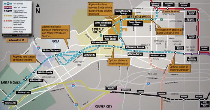 Alternative #16 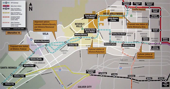 |
|
|
|
Post by Tony Fernandez on May 7, 2008 7:06:54 GMT -8
I guess I missed this, but why did they choose a forced transfer at Hollywood/Highland?
|
|
|
|
Post by Dan Wentzel on May 7, 2008 7:56:12 GMT -8
I guess I missed this, but why did they choose a forced transfer at Hollywood/Highland? I'll be attending tomorrow night's presentation, but Kymberleigh Richards stated the following on the Metroriderla.org blog, To me that sounds like this was only considered as an offshoot of the Red line southwest. Did the MTA even consider that there would be trains running directly from the Valley to the Westside? Perhaps it is modality. Maybe the SantaMonica/LaCienega connector is light rail as opposed to heavy. I still yet to see proof that Metro takes seriously the need for a direct public transit alternative traveling between the Valley and the Westside that doesn't require multiple transfers. I will be making this point in my comments on Thursday. If this is heavy rail, direct trains from the Valley would work well with either Alignment 11 or 16. If it is light rail, then I understand the transfer. The missed opportunity of a direct service between North Hollywood and Century City means the Sepulveda LRT project is needed even more than ever. |
|
|
|
Post by kenalpern on May 7, 2008 8:16:20 GMT -8
I believe it's engineering and the need to shut down Hollywood/Highland if a direct connection is done. Kym explained it to me before but I forgot the specifics.
I very much like Alternative #16, and even with the transfer I think we'd see excellent ridership. A future 405 subway, either LRT or HRT will likely not occur until we see the Purple Line reaching Westwood.
|
|
|
|
Post by Dan Wentzel on May 7, 2008 8:19:39 GMT -8
I believe it's engineering and the need to shut down Hollywood/Highland if a direct connection is done. Kym explained it to me before but I forgot the specifics. I very much like Alternative #16, and even with the transfer I think we'd see excellent ridership. A future 405 subway, either LRT or HRT will likely not occur until we see the Purple Line reaching Westwood. The Sepulveda BRT proposal is very much needed then. That would show higher than expected ridership, like the Orange Line, both of which could then be upgraded to light rail. |
|
|
|
Post by Tony Fernandez on May 7, 2008 8:21:16 GMT -8
I think I like 11 more. I don't like all the twists and turns of #16 for such a short distance that some kind of shuttle could cover. That diversion is basically just for The Grove/Farmer's Market and CBS Studios right? I'd rather stay under Wilshire instead of duplicating service with two subway lines between Beverly Center and Wilshire/La Cienega.
Maybe the people who financed The Grove can put up money for some sort of trolley from Beverly Center to The Grove, or maybe that's just wishful thinking.
|
|
|
|
Post by masonite on May 7, 2008 8:52:46 GMT -8
I think I like 11 more. I don't like all the twists and turns of #16 for such a short distance that some kind of shuttle could cover. That diversion is basically just for The Grove/Farmer's Market and CBS Studios right? I'd rather stay under Wilshire instead of duplicating service with two subway lines between Beverly Center and Wilshire/La Cienega. Maybe the people who financed The Grove can put up money for some sort of trolley from Beverly Center to The Grove, or maybe that's just wishful thinking. I am leaning towards that as well. It would be nice to hit the Farmer's Market, but I don't think it is really worth the extra cost and delay to passengers going between Downtown and the Westside. Also, I have reservations about the Pink Line. While the stations seem well placed and it would have nice ridership, creating all these branches and short lines also creates problems, which is why you need a transfer at Hollywood/Highland. It is really better to have long continuous lines for more efficiency. Everyone talks about one seat rides with these branches, but then you are just cutting off half the riders who wanted to go to the other branch. For example, when the Hollywood Red Line opened, service went down for the Wilshire district subway stations, because half the trains went to Hollywood instead. Not saying these things shouldn't necessarily be done, but it does create some operational issues. The more I look at the map, the more I think an extension of the Crenshaw Line to Hollywood/Highland makes more sense than a Pink Line. Certainly, would be cheaper than a Pink Line and much more realistic. Yes, it would cut out some key areas of the Pink Line, but when you are talking limited funding I think you need to be realistic. A Crenshaw extension also connects the Valley and Hollywood to Expo and LAX (and all Crenshaw station)area much better than the Pink Line. Finally, the reported cost keeps going up. I wonder where they are getting these figures. Are they not considering Madrid type of construction techniques that could really keep this down? |
|
|
|
Post by Dan Wentzel on May 7, 2008 9:50:26 GMT -8
The more I look at the map, the more I think an extension of the Crenshaw Line to Hollywood/Highland makes more sense than a Pink Line. Certainly, would be cheaper than a Pink Line and much more realistic. Yes, it would cut out some key areas of the Pink Line, but when you are talking limited funding I think you need to be realistic. A Crenshaw extension also connects the Valley and Hollywood to Expo and LAX (and all Crenshaw station)area much better than the Pink Line. Well, leaving out "key areas" is a little cavalier. A Crenshaw Line station up LaBrea is inadequate. It totally leaves WeHo out of the system for starters and does nothing to increase mobility north/south on the westside. It just adds to the north/south mobility already existing on the eastside with the Red Line. (LaBrea is not considered "westside"). If a northern extension of the Crenshaw Line went up San Vicente to Fairfax or La Cienega rathern than just LaBrea, then the argument might have more validity. It doesn't make sense to have a line on LaBrea, that close to Vermont, then nothing between LaBrea and Sepulveda. I would oppose any proposal that just had the Crenshaw Line going up LaBrea, without another line up La Cienega. Fairfax splits the difference, I guess. We eventually need both the Pink Line on La Cienega and the Crenshaw Line up LaBrea, and of course, it's all expensive. Whiile I certainly prefer the LaCienega & LaBrea approach, people who want only one north-south extension of the Crenshaw Line should lobby for Fairfax, which was the original north/south routing for the Red Line before politics forced it to be constructed on Vermont. After southern Los Angeles gets the Blue Line, the Green Line, the Crenshaw Line and the middle of the Expo Line, and the Eastside gets two Gold Line extensions, why should the Westside get shortchanged? |
|
|
|
Post by wad on May 8, 2008 4:21:33 GMT -8
I am leaning towards that as well. It would be nice to hit the Farmer's Market, but I don't think it is really worth the extra cost and delay to passengers going between Downtown and the Westside. The Third Street stations would generate more ridership at more hours. The extra cost comes in shooting the moon for the downtown-to-Westside set. In other words, why are we building a 21-hour subway for a 4-hour problem? Moreover, the delay is minuscule. We're talking less than 5 minutes here, and that's over a long distance. Remember, shopping centers and hospitals are job centers as well. They generate traffic from patrons and employees. They also generate a ton of ridership on Metro buses, so we know rail ridership is a sure thing. |
|
|
|
Post by kenalpern on May 8, 2008 5:34:25 GMT -8
As with Century City, the Beverly Center/Farmer's Market diversion is what the subway is all about, and the elimination of a few unnecessary stations on Wilshire Blvd. would absolutely make up for it. We're also trying to accommodate West Hollywood and Beverly Hills as well as Los Angeles with this one line. Let's build this right the first time and get the best ridership.
|
|


