|
|
Post by JerardWright on Feb 22, 2008 10:51:57 GMT -8
Crenshaw light-rail route picked
By Gene Maddaus Staff Writer
Article Launched: 02/21/2008 10:10:48 PM PST
While the "subway to the sea" has dominated the discussion of the future of transit in Los Angeles County, officials are laying the groundwork for a project that has gotten much less attention: a light-rail line along Crenshaw Boulevard.
The Crenshaw line would connect the Expo Line to the Green Line, and pass within a mile of Los Angeles International Airport. It has a higher priority than a subway extension along Wilshire Boulevard and, unlike the Wilshire line, it has committed funding.
This week, the Metropolitan Transportation Authority announced it has also settled on a preferred route for the Crenshaw line, bringing it closer to reality.
At a community meeting Wednesday night, MTA officials released a plan to run the line along existing track through an industrial area of Inglewood, avoiding the city's main commercial thoroughfares.
Roderick Diaz, the project manager, said cost had been a major consideration. That drew some fire from community members, who accused the staffers of skimping on the line, which could make it harder for passengers to use.
"It doesn't maximize the benefit of being in Inglewood," said Councilman Danny Tabor. "Don't let cost be the driving factor. Ridership is what you're going to need in the long run to make anything profitable." The MTA also has shelved the idea of extending the Crenshaw Line north to link up with the existing subway terminus at Wilshire Boulevard and Western Avenue.
Diaz said that Crenshaw becomes too narrow north of Exposition and that the surrounding neighborhood is incompatible with rail transit.
That means the entirety of the Crenshaw Line will be south of the Santa Monica (10) Freeway, and its only link to downtown Los Angeles will be via the Expo Line, which is now under construction.
The MTA's proposal is to build track along Crenshaw Boulevard from Exposition Boulevard to just north of Florence Avenue, passing through bustling commercial areas in Leimert Park and Hyde Park.
The line would then turn west to pick up existing freight track, passing through Inglewood and over the San Diego Freeway. It would turn south and run through a trench as it passed LAX, before linking up with the existing Green Line station at Aviation Boulevard.
The project is still many years away, but the MTA staff is beginning the process of reaching out to the local communities for reaction in advance of preparing an environmental report, which should be finalized in 2010.
One of the most tantalizing possibilities is that the Crenshaw Line could provide rail access to LAX. That would require the cooperation of Los Angeles World Airports, which has periodically considered building a "people mover" to carry passengers between the terminals and a rail station.
In a letter last fall, LAWA officials encouraged the MTA to strongly consider the needs of air passengers when deciding where to put the Crenshaw Line. Specifically, LAWA floated the possibility of a terminal at Century Boulevard and Aviation, where the rail line, bus lines and a people mover could converge.
The MTA's recommended route would keep that option alive, though the idea of a central passenger collection point has been criticized because it might create a potential terrorism target. The concept has been dormant since Los Angeles Mayor Antonio Villaraigosa was elected.
Another key element of the MTA plan is that Crenshaw trains would be able to use Green Line and Expo Line tracks - meaning that passengers could take a train from home in Leimert Park to work in El Segundo without having to switch trains. That would not be possible if the MTA had chosen to run the track along Prairie Avenue or Hawthorne Boulevard to the Green Line, as some in Inglewood would have preferred. Had the MTA chosen that route, Crenshaw passengers would have had to get off the train and go to a different platform to catch the Green Line, as is now required at the intersection of the Green Line and the Blue Line in Watts.
The MTA's decision also means that the track will not stretch down into Hawthorne. An earlier proposal called for the line to extend as far south as Hawthorne and El Segundo boulevards, but that is now off the table.
Several Inglewood officials have urged the MTA to bring the train along the city's busiest boulevards. Some have suggested turning south at Prairie Avenue and then west at Century Boulevard, which would allow the train to pass by LAX while also cutting through the heart of Inglewood's commercial area. Diaz suggested that such a detour would cost an extra $500 million to $800 million. As is, the project is expected to cost $1 billion to $1.6 billion.
The MTA is also considering a cheaper option: building a dedicated busway along the existing freight lines. That idea, however, has considerably less public support. The MTA is now soliciting public comment on where to place bus or rail stations.
WANT TO GO?
The MTA will hold two more community meetings to hear public comment on the Crenshaw Line:
10 to 11:30 a.m. Saturday at the Nate Holden Performing Arts Center, 4718 W. Washington Blvd., Los Angeles.
6:30 to 8 p.m. Monday at the Wilshire United Methodist Church 4350 Wilshire Blvd., Los Angeles.
|
|
|
|
Post by JerardWright on Feb 22, 2008 11:12:11 GMT -8
If the northern section is deffered what we should address is providing provisions for a future Northern extension by including knockout panels in the below grade separation at Coliseum or 39th (similiar to what was done for the Blue Line tunnel at Olympic/Flower with anticipation of the Harbor Transitway being converted to rail) so that a lot of $$$ and time isn't wasted to provide the future needed tunnel connection by having to tear down and rebuild Crenshaw/Expo to extend the route north and they should still study the northern alignment in the EIR and emphasize the timely need to connect with the Purple Line once the Purple Line makes it's mark westward.
As for the southern end, the City of Inglewood and the developer need to develop it's own detailed master plan for that site and provided easements and right-of way provisions for a grade separated right-of-way that the developer could pay for in exchange for denser development along the right-of-way that would start at RZ/C4 mixed use ground floor retail on Prairie/Transit Corridor then taper down to R 1/1.5 right next to the gated housing community on the eastern end of the property with room to add parks, green space even a school to stimulate a well planned village community.
|
|
|
|
Post by kenalpern on Feb 22, 2008 17:26:51 GMT -8
I welcome any efforts by anyone (including a letter from The Transit Coalition) advocating the betterments/idea you've suggested, Jerard. For some time now, I've concluded that a "Phase One" to connect the Expo and Green Lines is the right first step, but that a "Phase Two" that involved an extension to the Purple Line was in need of discussion (and sooner, not later).
As to the southern end, I don't have much in the way of easy answers. I really, really don't want to slow down any efforts by the City of Inglewood if it wants more rail/transit-based communities, and if it wants more rail in its boundaries. I sympathize and respect where that City is coming from. I also respect where the City of Redondo Beach is coming from in that it wants the Green Line to go all the way to the bus/transit center by the South Bay Galleria.
I envision this "Phase One" of the Crenshaw as an awkward but vital north-south line that is sort of but not really either Westside or South Bay, but which does service both areas in an incomplete manner. Just as the northern extension to the Purple Line best helps the Westside, I would say a big southern extension project involving a Hawthorne/Prairie project that goes all the way south to (and includes in a Green Line loop) the South Bay Galleria Mall is a singular project that needs exploration and discussion sooner and not later.
I do NOT think that any discussion of a rail line down Hawthorne Blvd. south of the Galleria Mall is a politically or operationally fruitful one at this immediate time. Perhaps in another 20 years, but including the northern half of the South Bay in future Green/Crenshaw Line expansion plans is as smart and comprehensive as is dismissing the southern half of the South Bay for an inclusion that (I strongly suspect) relatively few local residents desire.
In short, I like--no, love--this Crenshaw LRT plan--but am quick to point out that its full potential will occur when it has a northern Purple Line extension and the right number of South Bay/Green Line connections (Aviation/Imperial, and a Hawthorne/Prairie corridor extension).
|
|
|
|
Post by darrell on Feb 22, 2008 22:09:33 GMT -8
I'm not at all surprised the Crenshaw study recommended deferral of north of Exposition. If I recall, the last one did the same.
I keep thinking, though, of not just a line up to Wilshire but of a north-south corridor all the way to Hollywood, not unlike the once-planned La Cienega Freeway.
Build the Purple Line west along Wilshire (or my preferred option to jog north to 3rd Street from Fairfax to La Cienega). Then serve West Hollywood with this north-south line crossing the Purple Line.
One routing could be Damien's tunnel from Expo & Crenshaw to where San Vicente branches off Venice Blvd. (Vinyard to followers of the Pacific Electric), once again use the San Vicente median for mostly-surface tracks up to WeHo, then east along Santa Monica Blvd., and finish with a tunnel to Hollywood & Highland. These two tunnels would be similar in length to the Eastside Gold Line tunnel.
This does backtrack a couple of miles, but should be more affordable as well as serving the core of WeHo better than a route up La Brea. Purple Line transfer would be at La Cienega and either Wilshire or 3rd. It would be interesting to see each modelled for ridership.
|
|
|
|
Post by damiengoodmon on Feb 23, 2008 8:27:35 GMT -8
As I explained to others,
By just getting the Wilshire/La Brea diversion on the map, better than a 100 conversations, begins to explain the need and capability of this line to serve as the north-south line needed in the basin between Vermont and Sepulveda/405.
|
|
|
|
Post by darrell on Feb 23, 2008 9:55:08 GMT -8
I'm going to comment on my own post. There may not be enough right-of-way on San Vicente, especially north of 3rd, or on Santa Monica Blvd. after West Hollywood rebuilt it, to fit median tracks.
If not, that removes the most compelling reason to do this route.
I see three tiers of main transit lines in Los Angeles:
1. Subways in the few highest-density corridors, e.g. Wilshire;
2. Light rail, mostly at-grade, along existing rights-of-way and boulevard medians where they fit, e.g. Pasadena and Eastside Gold Lines, Expo, Crenshaw;
3. Rapid bus in boulevards, upgraded with dedicated or queue-jumper lanes, better signal priority, etc., hopefully electrified in the future.
LA is too vast and money too tight to expect much more. Unfortunately, I don't know where this leaves Crenshaw north of Expo.
|
|
|
|
Post by bluelineshawn on Feb 23, 2008 11:16:01 GMT -8
In the long term the proposed Crenshaw route makes a lot of sense. In the short term, absent another north/south rail corridor on Vermont it may not look like it does.
|
|
|
|
Post by JerardWright on Feb 23, 2008 11:19:25 GMT -8
I'm going to comment on my own post. There may not be enough right-of-way on San Vicente, especially north of 3rd, or on Santa Monica Blvd. after West Hollywood rebuilt it, to fit median tracks. If not, that removes the most compelling reason to do this route. That was something I've thought about too and I came to the same conclusion in regards to San Vicente/3rd could be better served by a direct Purple Line extension and since that location is so close to West Hollywood via walking or quick shuttle it's better to get as much as we can out of our subway infrastructure. This leaves really two options in terms of connecting a true North-South route. La Brea or Fairfax. Both have their merits and could both have justification as being built as a subway. Fairfax has the Farmers Market/Grove/CBS TV City, La Brea has the West Hollywood Gateway and more consistent residential density and commercial streetscape. For a touch of visioning, if a Venice Blvd LRT ever gets off the ground, one thing that could be looked at is tying a Venice Blvd LRT to this North-South subway thus creating a Mid-City Regional Connector that would have the same idea as the Downtown Regional Connector except it would tie into a stub 3 track terminal in Hollywood. That is a good multimodal approach, I would add busways (more in line of El Monte Busway than Orange Line) even track guided busways like in Sao Paulo and Austrailia that would allow a tighter pavement cross section, better vehicle ride and the ability to reach outer areas to transit and then wisk them quickly on the guideway to the destinations. This would be located between LRT and Rapid Bus. |
|
|
|
Post by darrell on Feb 23, 2008 12:30:03 GMT -8
Then there's the question of aerial rail. I see monorail proposals as too expensive and having too much impact (column space, visual shadowing) to do along boulevards.   And add limited usefulness of flood channel routes. 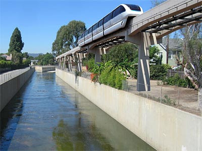 Freeway medians are also frequently mentioned, but combine the problems of column fit and cost with poorly-located stations (no illustration yet). Same for the latest MagLev proposals. I have thought a lot about aerial conventional rail along the I-405 corridor from LAX to the Valley. I had thought of using the side right-of-way, not the median, and turning away from the freeway for stations, like at the north-east corner of Wilshire and Veteran in Westwood. But the current I-405 reconstruction may not leave enough space. |
|
|
|
Post by darrell on Feb 23, 2008 12:35:37 GMT -8
I would add busways (more in line of El Monte Busway than Orange Line) even track guided busways like in Sao Paulo and Austrailia that would allow a tighter pavement cross section, better vehicle ride and the ability to reach outer areas to transit and then wisk them quickly on the guideway to the destinations. This would be located between LRT and Rapid Bus. I wonder if short sections of busway grade separations would substantively help Rapid lines? Someone cornered me a couple of years ago about Australian BRT that did that. |
|
|
|
Post by JerardWright on Feb 23, 2008 15:56:46 GMT -8
I would add busways (more in line of El Monte Busway than Orange Line) even track guided busways like in Sao Paulo and Austrailia that would allow a tighter pavement cross section, better vehicle ride and the ability to reach outer areas to transit and then wisk them quickly on the guideway to the destinations. This would be located between LRT and Rapid Bus. I wonder if short sections of busway grade separations would substantively help Rapid lines? Someone cornered me a couple of years ago about Australian BRT that did that. I think it could and the Orange Line is a perfect example of this. At three crossings, Sepulveda, Van Nuys and Valley College are sections that should have been grade separated simply because they can allow their speed to make up the lack of unit capacity by allowing more buses through the busway and even operate true Express or direct point to point routes using the busway as a conduit. This is why the TransMileno is a success it impliments that exact idea. For the track guided busway in Adelaide, it worked for them to connect their Downtown to sprawled low density suburbs to achieve higher speeds, smooth ride and smaller right-of-way footprint. The originator of these Track guided busways was Essen Germany which utilized trolleybuses on track guided sections on both tunnels, grade separated and at-grade with street/pedestrian crossings. They've stopped operating them once they couldn't find a bus manufacturer to build a bus to their narrower roadway cross section of 8'6". Sao Paulo is the high range version of track guided BRT because theirs are grade separated (over 200,000 riders on a 10 mile busway) on most of the route and they use Bi-articulated Electric trolleybuses and for a while they were flirting with coupling the trolleybuses into a short train between two busy points to reduce operational costs, much like LRT because the horizontal guidewheels provide a smoother ride and better stability much like the set up of a monorail. |
|
|
|
Post by darrell on Feb 23, 2008 21:00:43 GMT -8
I like the part about electric trolleybuses. Do you have any good links to photos? On the subject of aerial light rail, and appropriate to this thread's other subject of the late OCTA CenterLine, here is a simulation of the proposed station on Bristol at MacArthur, in the south edge of Santa Ana, almost to Costa Mesa and South Coast Plaza. 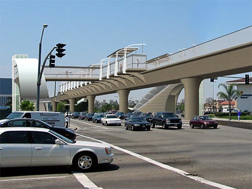 The double-track aerial guideway was standard cast-in-place concrete freeway bridge construction. The idea of the station was to minimize its bulk by using thin side-platforms. Pedestrian bridges would take passengers to the sides of the street, with elevators and stairs to the sidewalk. Note also the columns take a lane of the street. Passengers would have to go down, across, and back up the other side to change direction. Missing catenary? At the City of Irvine's request, trains were proposed to be low-floor LRVs with both pantographs for at-grade sections and third-rail shoes for elevated sections, with a switch done at the first aerial station. My conclusion is, this is probably about as light as aerial rail could be built, and it's still a lot of concrete in the air, especially at stations. Monorail would have a little lighter guideway, but bulkier stations. |
|
|
|
Post by masonite on Feb 23, 2008 21:32:04 GMT -8
Regarding the Crenshaw Line, I still don't necessarily think that this should be the next rail line. It seems there are several problems in that:
1. It may not serve many people due to its routing along a cheaper easier to build route near industrial areas not places like Downtown Inglewood
2. There may be similar problems with the community as Expo given it is largely the same community.
3. It won't connect to the Purple Line (at least for many many years). Is there really much demand for a line that only connects Expo and the Green Line (which the Blue Line will already do farther east)?
It may be ahead of the Purple Line extension, but that doesn't make it right. The last thing we need is another lightly used line with problems with the community. Lets build the portions of the rail system that are missing now, but essential (like the DTC and Subway to the Sea). These projects are also more cost effective, which should count for something. This can be BRT for now until money is found for less critical rail like this and the Gold Line extension to Claremont.
|
|
|
|
Post by JerardWright on Feb 24, 2008 10:35:51 GMT -8
Regarding the Crenshaw Line, I still don't necessarily think that this should be the next rail line. It seems there are several problems in that: 1. It may not serve many people due to its routing along a cheaper easier to build route near industrial areas not places like Downtown Inglewood The railroad right of way hits Downtown Inglewood and gives the city the ability to transform the junkyard industrial tracts into housing/commercial/retail. It could be said that proper mitigation in this phase of this project will help be an olive branch to the community. Also the community knows about this project defering it to a later date and then speeding ahead to build the Purple Line is the exact thing that create the same problems or worse. Considering that the Blue Line is carrying the bulk of that load and the existing 40/740, 210/710 buses heaviest section is the area in question from the Green Line to around King/Crenshaw is a very good indicator of who will use it and how it's used. Where a BRT would give the community all the construction headaches and costs with none of the benefits. FWIW with the Foothill Gold Line, the only usefulness is to Azusa/Citrus College any further east is a waste. |
|
|
|
Post by kenalpern on Feb 25, 2008 7:18:12 GMT -8
In short, the need to connect the Green with the Expo Line is HUGE, and it is my strong belief that by the time this is being built there will be PLENTY of interest and planning to connect this to the Purple Line. There were several slides about connecting this to the Purple Line, so it is likely that the Purple Line effort will INCLUDE a much-needed, if not obvious connection of the Crenshaw and Purple Lines when the Subway finally gets built.
The argument about whether the Downtown Connector or Subway should precede the Crenshaw Line was fought and decided long ago. It's the law--deal with it, everyone.
The biggest question: can L.A. County politicians and voters understand that all these projects--extensions of Expo, Foothill Gold, Green and Purple Lines, as well as new Crenshaw and Downtown Connector Lines that tie them together--must all be expedited for funding and construction by decades.
If we can export tens of billions of dollars abroad to build and rebuild the infrastructure of other countries, can we not do the same locally without decrying that it's "expensive"?
|
|
jomiy
New Member

Posts: 10
|
Post by jomiy on Feb 28, 2008 19:02:03 GMT -8
Did the MTA identify the set of alternative routes and modes that were to be studied in the AA?
With cost being a major factor, it appears the LPA will likely be along the Harbor ROW to LAX and completely bypass the future Hollywood Park redevelopment. The AA will probably adopt the landuses in Inglewood's General Plan Update so it'll be interesting to see riderships of each alternative.
Urban form wise, I'd oppose elevated LRT. I'd keep it at grade with grade sep portions at high traffic crossings.
|
|
|
|
Post by JerardWright on Mar 8, 2008 16:55:10 GMT -8
|
|
|
|
Post by darrell on Mar 8, 2008 21:38:27 GMT -8
Thanks, Jerard! They're sharp enough to make the options clear.
Do you know what the little kink just south of Expo on Crenshaw is, at the north end of the below-grade section?
|
|
|
|
Post by JerardWright on Mar 8, 2008 22:59:19 GMT -8
Thanks, Jerard! They're sharp enough to make the options clear. Do you know what the little kink just south of Expo on Crenshaw is, at the north end of the below-grade section? It looks like it's drawn that way visually show that there's a transitional change in that area because if the dashes would make it look like it's a below grade option from Expo to Vernon rather than due south of Expo to Vernon. |
|
|
|
Post by kenalpern on Mar 9, 2008 1:19:18 GMT -8
Do you think that below grade option should, under ideal circumstances, procede up to Crenshaw/Exposition and continue northwards to a future Purple Line connection?
|
|
|
|
Post by jejozwik on Mar 9, 2008 14:27:45 GMT -8
im liking the grade separation options
is this still up for comments?
|
|
|
|
Post by JerardWright on Mar 9, 2008 16:17:16 GMT -8
Do you think that below grade option should, under ideal circumstances, procede up to Crenshaw/Exposition and continue northwards to a future Purple Line connection? Simple answer, Hell Yes it is should!  Write in your letter to add kncokout panels in the northern (around 39th or Coliseum) and southern (around Vernon or 48th Street) end of the below grade separation so that future underground connections on the Northern end can proceed to connect to the Purple Line. On the southern end that will be needed for capacity upgrades. im liking the grade separation options is this still up for comments? Yes, it is still up for public comment. |
|
|
|
Post by damiengoodmon on Mar 9, 2008 16:31:38 GMT -8
jeremy,
crenshaw@metro.net
Ken,
It's not possible to fit LRT north of Expo without grade separation or taking out traffic lanes.
|
|
|
|
Post by kenalpern on Mar 9, 2008 22:46:48 GMT -8
Perhaps I'm misstating my question, and I apologize for any confusion. I am well aware of, and entirely support, a proposed subway portion of the Crenshaw Line north of Crenshaw and extending to the Purple Line at, say Wilshire/La Brea. I am also aware that this MUST be a subway, but that because the financial/planning aspects of this project only take it to Exposition/Crenshaw (at-grade right now, correct?) we need to ask ourselves:
Is is possible to have the line be built so that the Crenshaw Line's portal at Crenshaw/Exposition is arranged to have a subway (the Expo Line there is at-grade, I believe) so that it can more easily proceed/continue north underground to the Purple Line, or will we have to build and then rebuild the Crenshaw Line station at Crenshaw/Exposition to convert it from at-grade to a subway?
I like and support Jerard's ideas of knockout panels should the rebuilding of the Crenshaw Line there be needed, but it would probably be smarter and more cost-effective to have the trenched or covered Crenshaw Line south of Exposition be underground during the original construction of the project.
|
|
|
|
Post by darrell on Mar 9, 2008 22:53:23 GMT -8
... to have the trenched or covered Crenshaw Line south of Exposition be underground during the original construction of the project. Although if they build it as a branch of the Expo Line (as was suggested in the latest Regional Connector presentation), it will be an at-grade junction, potentially descending to a portal a little farther south. |
|
|
|
Post by JerardWright on Mar 9, 2008 23:38:45 GMT -8
... I am also aware that this MUST be a subway, but that because the financial/planning aspects of this project only take it to Exposition/Crenshaw (at-grade right now, correct?) we need to ask ourselves: Is it possible to have the line be built so that the Crenshaw Line's portal at Crenshaw/Exposition is arranged to have a subway (the Expo Line there is at-grade, I believe) so that it can more easily proceed/continue north underground to the Purple Line, or will we have to build and then rebuild the Crenshaw Line station at Crenshaw/Exposition to convert it from at-grade to a subway? Yes, it's possible to do that with a portal of the grade separation around Coliseum Street so that an at grade junction can be built but it will require the knockout panels for future northern extension without the intense disruption of pausing not one but two LRT lines. |
|
|
|
Post by kenalpern on Mar 10, 2008 6:20:40 GMT -8
...but is it more cost-effective to bring the Crenshaw Line underground so that it's below the Expo Line, instead of the knockout panel scheme?
Legally, we MUST use the knockout panel scheme because the Wilshire Subway idea is just too conceptual to presume it'll ever exist...but if 2-3 years down the road we have a Wilshire Subway route that's definite (and I'll go out on a limb and suggest the Crenshaw Line won't be under construction then!!!), is it cheaper (or legal) to presume that the Crenshaw Line will be underground at Crenshaw/Exposition and build it according to Wilshire Subway specifications?
(It's similar to the issues of not having to rebuild at National/Washington by extending the Expo Line's first phase to Venice/Robertson).
In short, I support Jerard's ideas and initiatives 105%, but is it smarter, more cost-effective and more voter-pleasing to have the first phase of BOTH the Wilshire Subway and Crenshaw Line projects include a connection at Wilshire/La Brea if we get the planning and funding requirements accomplished by the time construction starts?
(i.e., Jerard's knockout panel plan in 2008, but perhaps scrapping it for a full Crenshaw/Wilshire connection that includes a Crenshaw/Exposition underground station at Crenshaw/Exposition in, say, 2011-2012 if we can pull it off).
|
|
|
|
Post by JerardWright on Mar 10, 2008 8:27:11 GMT -8
...but is it more cost-effective to bring the Crenshaw Line underground so that it's below the Expo Line, instead of the knockout panel scheme? Legally, we MUST use the knockout panel scheme because the Wilshire Subway idea is just too conceptual to presume it'll ever exist...but if 2-3 years down the road we have a Wilshire Subway route that's definite (and I'll go out on a limb and suggest the Crenshaw Line won't be under construction then!!!), is it cheaper (or legal) to presume that the Crenshaw Line will be underground at Crenshaw/Exposition and build it according to Wilshire Subway specifications? Yes and No. I'm anticipating a voter initiative failing to make sure we dot our I's and cross the T's, but it's to ensure that the pieces are built accordingly, if a voter funding source were to pass for a full Crenshaw Corridor to the Purple Line then all we'd have to do is eliminate the design feature in the construction phase. It's better to include this in the document now, than to scramble which makes all of LA look bad and begin to give the news media plenty of juicy bits of damage to suggest a repeat of all the subway headaches in the 80's and early 90's. Having a voter initiative passing and preparing an EIR are two different things. It's better to get the idea into the EIR in case a voter ballot doesn't pass so that we're covered. |
|
|
|
Post by kenalpern on Mar 10, 2008 10:26:05 GMT -8
Agreed, and well-said, Jerard. I suspect that if a voter initiative this fall passes, a lot of cost-effective planning for bigger projects will occur.
|
|
|
|
Post by Dan Wentzel on Mar 10, 2008 10:55:23 GMT -8
I'm actually of the belief that north of Expo, the line should cut over via San Vicente to La Brea, Fairfax or even La Cienega and then cut back over to the H/H Red Line station.
A straight line to Wilshire may not be in the long-term interests of this line if they have to transfer at Crenshaw/Wilshire, when a one-seat ride downtown from LAX is already available via Expo.
There needs to be a north/south route on either Fairfax, LaBrea or LaCienega, and so I'm personally glad a route to Wilshire has not been planned yet. Crenshaw/Wilshire is unlikely to be extended north of Wilshire. An LRT going from LaBrea, Fairfax, LaCienega, SanVicente and Wilshire may be.
|
|


