|
|
Post by Justin Walker on Sept 10, 2008 20:04:26 GMT -8
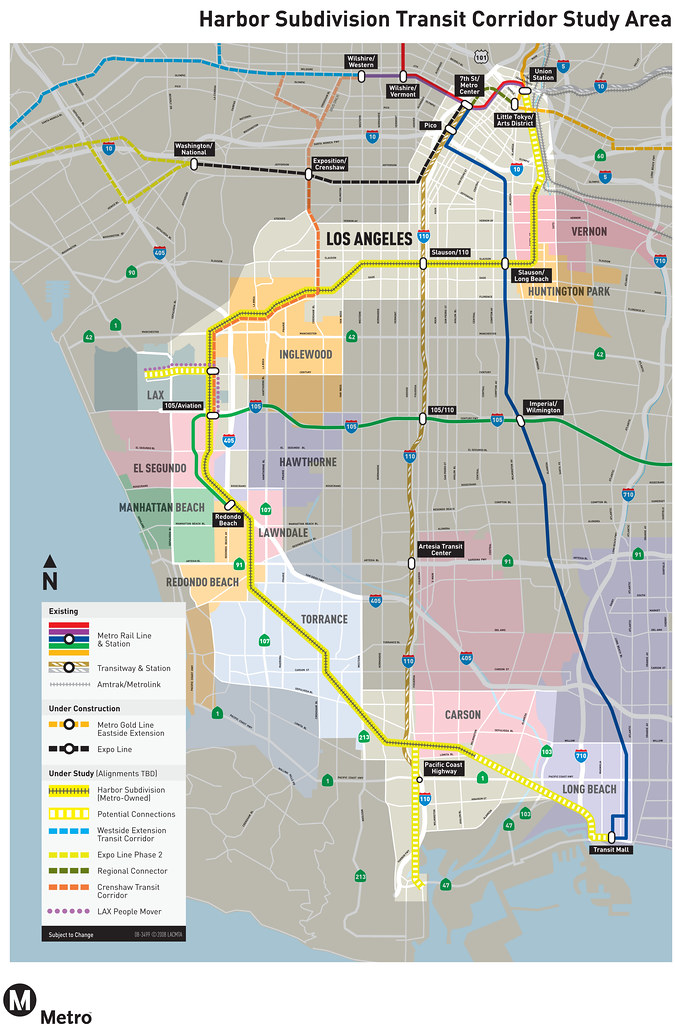
From a September 8 Metro News Release: www.metro.net/news_info/press/Metro_146.htmMetro to Hold Community Meetings to Discuss Transportation Options for the Harbor Subdivision Transit Corridor Metro will hold a series of community meetings in late September as part of their Alternative Analysis Study (AA) for the Harbor Subdivision Transit Corridor. The study will examine potential transit service along the Metro-owned Harbor Subdivision. The Harbor Subdivision is a freight rail corridor, approximately 26 miles in length that traverses southwest Los Angeles County from Vernon to Wilmington. In the early 1990’s, Metro purchased the portion of the corridor between Redondo Junction and Watson Yard, along with several other rail rights-of-way, to further the development of the region’s rapid transit system. The AA will evaluate a broad range of alternatives including Bus Rapid Transit (BRT) with dedicated bus lanes, various types of rail technology such as Light Rail Transit (LRT) and commuter rail, as well as “no-build” and Transportation Systems Management improvements. Though alternatives will generally follow the Harbor Subdivision corridor, potential alignment and improvement options outside the immediate Harbor Subdivision right-of-way also will be studied. In addition, the analysis will examine potential financing mechanisms outside the traditional funding sources commonly used for constructing and operating transit service. The study area will encompass approximately 26 corridor miles including the jurisdictions of Huntington Park, Vernon, City of Los Angeles, Hawthorne, Inglewood, El Segundo, Lawndale, Torrance, Manhattan Beach, Redondo Beach, Carson, Los Angeles County, and the port areas of Los Angeles and Long Beach. Together with the planned Crenshaw Transit Corridor, the Harbor Subdivision would establish a north-south transit link connecting the downtown Los Angeles area to LAX and potential South Bay area destinations. At the conclusion of the AA, Metro staff will recommend a course of action to the Metro Board, including possibly proceeding with an environmental document consistent with both federal and state requirements. Harbor Subdivision Study The study’s goals include improving mobility in southwestern Los Angeles County by introducing reliable, high-frequency transit service options, enhancing the regional transit network by interconnecting existing and planned rapid transit lines, providing an alternative mode of transportation for commuters currently using the congested I-405 and I-110 corridors, improving transit accessibility for residents of underserved communities along the corridor, and encouraging a mode shift to transit, reducing air pollution and greenhouse gas emissions. Public involvement is critical to the success of the Harbor Subdivision Transit Corridor project. Metro encourages the public to attend at least one of the meetings listed below to learn more about the Harbor Subdivision Transit Corridor Study and provide Metro with your feedback and/or suggestions. * Tuesday, September 23, 2008, 6:30-8:30 pm, Torrance Cultural Arts Center, George Nakano Theatre, 3330 Center Dr., Torrance, CA 90503 * Wednesday, September 24, 2008, 6:30-8:30 pm, Banning's Landing Community Center, 100 E. Water St., Wilmington, CA 90748 * Thursday, September 25, 2008, 6:00-8:00 pm, Westside Park Community Center, 2061 E. Gage Ave., Huntington Park, CA 90255 * Tuesday, September 30, 2008, 6:00-8:00 pm, El Segundo Public Library, 111 W. Mariposa Ave., El Segundo, CA 90245. The Early Scoping comment period will end on October 22, 2008. Comments will be accepted up until that date by sending them to Kathleen McCune, Project Manager, Los Angeles County Metropolitan Transportation Authority (Metro), One Gateway Plaza, Mail Stop: 99-22-3, Los Angeles, CA 90012. The public also can call (213) 922-4004 and leave a voice message or e-mail comments to HarborSubdivision@metro.net. |
|
|
|
Post by kenalpern on Sept 11, 2008 6:26:27 GMT -8
Thanks, Justin!
|
|
|
|
Post by Justin Walker on Sept 15, 2008 20:46:43 GMT -8
The Harbor Sub Study now has its own page on the Metro site! And I've got to say now Metro's list of ongoing studies is quite impressive: Congestion Reduction, Canoga, Crenshaw, Eastside 2, Harbor Sub, Regional Connector, and Westside. Anyways, the Harbor Sub page is here: www.metro.net/projects_studies/harbor_subdivision/default.htmThe Study Area Map is worth checking out, too. It offers a very optimistic-looking but completely possible outlook for transit projects in the region. |
|
|
|
Post by soundguise on Sept 30, 2008 8:31:40 GMT -8
Does anyone know if there was a presentation at these meetings and if so if it will be posted so we can all get a look at what is being discussed?
|
|
|
|
Post by jejozwik on Sept 30, 2008 9:05:32 GMT -8
|
|
|
|
Post by jejozwik on Sept 30, 2008 9:06:51 GMT -8
my comment:
|
|
|
|
Post by Justin Walker on Oct 4, 2008 10:37:40 GMT -8
|
|
|
|
Post by spokker on Oct 4, 2008 17:52:51 GMT -8
Thank you. I've been learning more about the Harbor Subdivision and the more I read the more potential I see for this corridor. I'm sure others already have their own vision for what should be built on it. |
|
|
|
Post by wad on Oct 5, 2008 4:46:07 GMT -8
I'm sure others already have their own vision for what should be built on it. Yes, there has been -- mainly on the old board. I argued over the point, too. I took the position that the Harbor Sub, the part from downtown to LAX, should be a light rail line. Most others here feel it should be a Metrolink line to get people fast from downtown L.A. to LAX. |
|
|
|
Post by Justin Walker on Oct 5, 2008 11:20:32 GMT -8
I argued over the point, too. I took the position that the Harbor Sub, the part from downtown to LAX, should be a light rail line. Most others here feel it should be a Metrolink line to get people fast from downtown L.A. to LAX. I'm in the Metrolink camp. With the Blue, Green, Expo, and Crenshaw lines in place, there will already be plenty of light rail from downtown through the area to the airport. Now, we need to use the full line for fast service from downtown to LAX and to the South Bay. |
|
|
|
Post by kenalpern on Oct 5, 2008 11:57:11 GMT -8
I agree that Metrolink is the best way to cost-effectively utilize this line, but the portion between Crenshaw and LAX must somehow be utilized for BOTH light rail and Metrolink without interfering with each (hopefully, they'll complement each other!).
I also believe that the Green Line must go to the South Bay Galleria Mall in a way that doesn't interfere with this Metrolink route.
|
|
|
|
Post by spokker on Oct 5, 2008 16:32:38 GMT -8
If the Green Line is extended I wonder if it would be continue to be grade separated the entire way.
|
|
|
|
Post by jejozwik on Oct 6, 2008 5:27:45 GMT -8
If the Green Line is extended I wonder if it would be continue to be grade separated the entire way. that would be the hottest option ;D |
|
|
|
Post by kenalpern on Oct 6, 2008 16:49:40 GMT -8
My understanding is that any Green Line extension to LAX absolutely WOULD be elevated, and I suspect that it would also be elevated to most of any route to the South Bay Galleria (I really can't speak much for the latter, although the area that goes through people's homes would probably have an at-grade portion because there would be no safety/traffic problems). I imagine that any Green Line extensions to West L.A. and the South Bay would be elevated where necessary, and any Norwalk extension would be a subway.
|
|
|
|
Post by whitmanlam on Oct 6, 2008 22:16:41 GMT -8
I agree that Metrolink is the best way to cost-effectively utilize this line, but the portion between Crenshaw and LAX must somehow be utilized for BOTH light rail and Metrolink without interfering with each (hopefully, they'll complement each other!). I also believe that the Green Line must go to the South Bay Galleria Mall in a way that doesn't interfere with this Metrolink route. |
|
|
|
Post by whitmanlam on Oct 6, 2008 22:21:56 GMT -8
I agree that Metrolink is the best way to cost-effectively utilize this line, but the portion between Crenshaw and LAX must somehow be utilized for BOTH light rail and Metrolink without interfering with each (hopefully, they'll complement each other!). I also believe that the Green Line must go to the South Bay Galleria Mall in a way that doesn't interfere with this Metrolink route. I think they should use those DMU trains, like for the San Diego Sprinter line. They look and feel just like light rail, and they can run on ordinary freight tracks. They're not as big as Metrolink engines, without the collision safety, but sometimes that's a plus if the train does not share track with freight locomotives. DMU is the way to go if it's not going to be electrified track. I would like for the Green line to go all the way up North along Sepulveda to at least West L.A. at the 10/405 interchange, then hopefully build it thru the heavily congested Sepulveda pass into the Valley. |
|
|
|
Post by jejozwik on Oct 7, 2008 5:04:05 GMT -8
DMU is the way to go if it's not going to be electrified track. but by the time this is going to go into service, metrolink could already have the cars for electrified lines. so theoretically you could also add electrified metrolink to the mix here |
|
|
|
Post by Gokhan on Oct 7, 2008 12:01:45 GMT -8
Let's hope Measure R passes! That might be the only way all these lines will be built!
|
|
|
|
Post by bluelineshawn on Oct 18, 2008 19:10:44 GMT -8
I haven't seen anyone post the study so here it is in case anyone hasn't seen it. |
|
|
|
Post by damiengoodmon on Nov 1, 2008 7:28:53 GMT -8
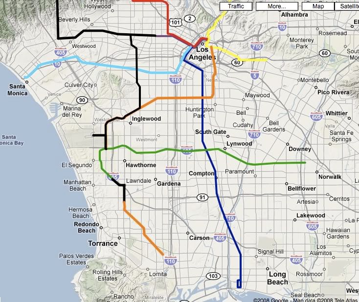
Dear Ms. Kathleen McCune: The Harbor Subdivision is a unique asset that unlike most other properties owned by MTA provides the opportunity to connect several communities throughout our broad county in need of high-speed rail transit. This is the second most important transit corridor study currently being conducted by the $3 billion transportation agency, behind only the Downtown Regional Connector. I. The Harbor Subdivision must be studied considering lines likely to branch off the right-of-wayMTA purports that it invests in major public infrastructure improvements to solve long-term problems. But corridor specific studies, evaluating short-term 10-20 year forecasts are inconsistent with that stated goal. As with all MTA environmental studies, the scope of the Harbor Subdivision Alternatives Analysis is too narrow. For a corridor with great capabilities such as the Harbor Subdivision, if the customary MTA mistakes are made in this study, the negative repercussions are epic. A tragic mistake in mode or alignment for the Harbor Subdivision could annually cost MTA millions of dollars and tens of millions of riders. The region would feel the mistake for generations. Simply, it is crucial that the Harbor Subdivision be studied in a scope that goes beyond 30 years and beyond the corridor boundaries. London had the vision to build tunnels in the 1860s, which are still operational today. Germans use stations with short spurs branching out, which every citizen understands to be future branch lines that will be built in 40 years. Such long-term visioning is needed if in no other MTA study, in this Harbor Subdivision Alternatives Analysis. The following is a map of the Harbor Subdivision from Downtown LA to Normandie/Pasatiempo (orange line), included among the existing and under-construction rail network (color lines) along with rail projects identified in Measure R (black lines): From a regional perspective, it’s clear that the 26-mile corridor will impact the planning of projects that will serve the region for the next 100 years. Specifically, the right-of-way can, should and likely will be utilized by many future lines. A. 405/Sepulveda Corridor Line Use of the Harbor Subdivision south of the 190th/Crenshaw junction, indeed south of the Marine Avenue Green Line Station must be viewed in the context of a future 405/Sepulveda line. Such a line could connect the San Fernando Valley to the South Bay, serving Westwood, West LA, Palms, Howard Hughes Center/Fox Hills, LAX and the South Bay Galleria, among other locations en route.  The 405/Sepulveda line could eventually extend east to Cal State Long Beach/Veterans Hospital and/or south into San Pedro: 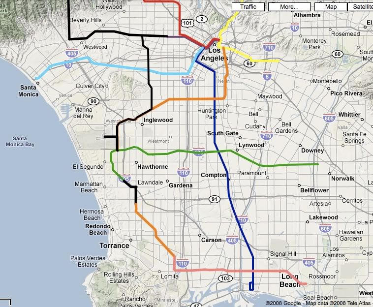 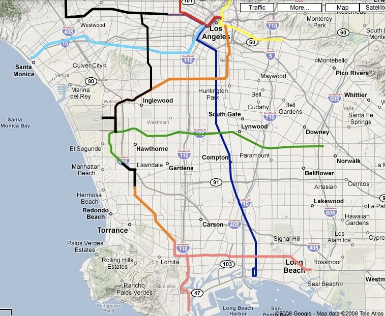 B. Gateway Cities Branch: The Harbor Subdivision presents the opportunity to connect the often-neglected southeast county Gateway Cities to the communities to the west (South Central LA/Inglewood/LAX) and/or north (Downtown LA). The Gateway cities could be connected by utilizing existing rights-of-way: the Los Nietos, La Habra and San Pedro Subdivisions. 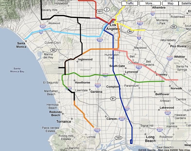 C. Playa Vista/MDR Branch: The Harbor Subdivision presents the opportunity to connect from the south or east a rail line to serve booming Playa Vista, Howard Hughes Center/Fox Hills, Marina Del Rey and Venice en route to Santa Monica, by branching off the right-of-way at Centinela and continuing down Jefferson and up Lincoln. 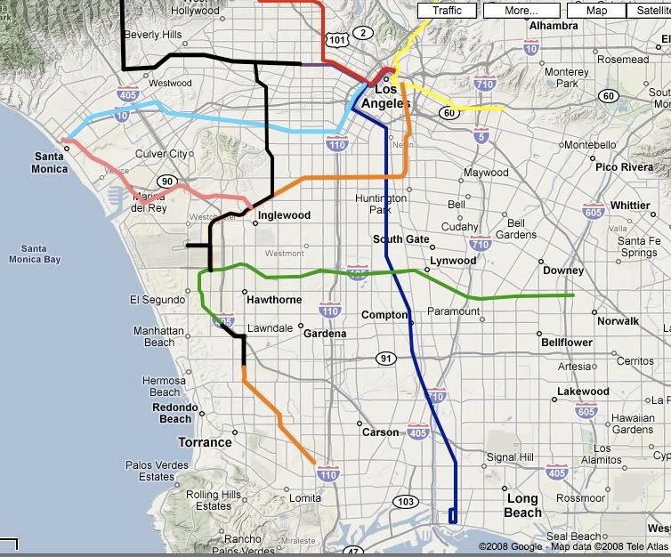 D. Crenshaw/Hawthorne Line: While in the near term, a Crenshaw Line that utilizes the right of way west of La Brea/Florence may be appropriate, for decades Crenshaw Line studies considered a line that traveled south down Hawthorne Blvd into Torrance. Hawthorne Blvd south of Florence has the highest residential density of any corridor in the county south of King Blvd and west of the 110 freeway. Such a line, within a broad rail network would prove successful if served by a rail line with fast operating speeds because it would serve a corridor currently without a freeway alternative. 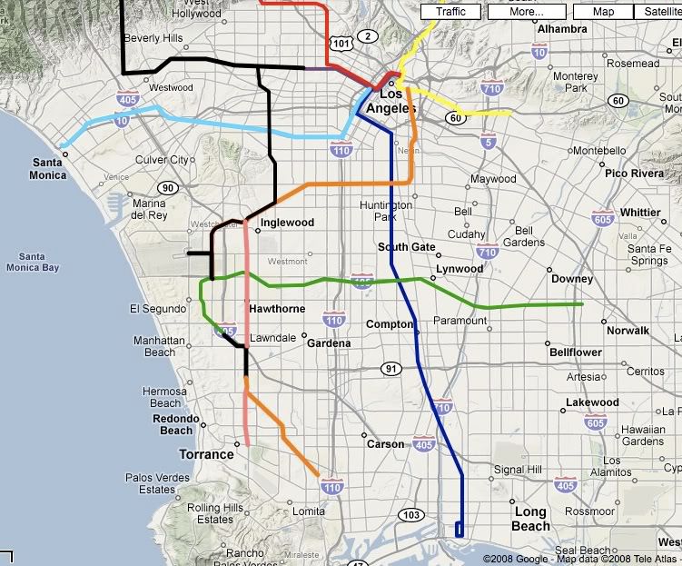 None of the above extensions/rail lines will be built tomorrow. But each of the communities/locations that would be served by the above extensions are either major job/economic centers, or dense residential and/or transit-dependent communities. They are communities and locations that eventually will need to be connected to our regional rail network if MTA’s is to ever reach or think of reaching mass transit ridership percentages comparable with other American cities of similar size. Thus, the decisions made in the near term on the Harbor Subdivision will have implications that impact the entire rail transit system in LA County south of the 10 freeway for the next 100 years. Therefore, it is crucial that near term decisions made on the Harbor Subdivision not prohibit the above future extensions 20, 30 or 50 years from now. Specifically, the corridor should be planned for 90-120 second headways or the capability to operate with such in the future, with minimal disruption to operations. There are ways of reducing capital costs of the initial investment, i.e. stations can be built as part of joint-development projects; knock-out walls can be constructed at locations for future stations that can’t afford to be built today, but are known to be needed in the future; projects can be expanded to capture economies of scale; projects can be built shorter; etc. But building incorrectly with limited capacity to expand is far more costly to correct, to the point of cost-prohibitive. II. The appropriate mode for the Harbor Subdivision is “Grade Separated Light Rail” A. Light rail vehicles provide the necessary flexibility If the true potential of the corridor is to be maximized, interlining (lines sharing the same tracks) should be and will be utilized on several sections of the Harbor Subdivision. With so many different communities served, a mode and vehicle is necessary that has the flexibility to operate in a variety of environments and integrate smoothly into MTA’s existing infrastructure. Light rail vehicles provide the required flexibility. 1. Future interlining underscores the importance of grade separation
The existing horrible traffic on our region’s streets and transit speeds required to handle long-distance commutes alone is enough to require grade separation of rail lines on the Harbor Subdivision. But the need for interlining accents the importance of grade separation, especially in the portion of the Harbor Subdivision between the Slauson Blue Line Station and LAX. "Grade Separated Light Rail” should be the focus of the study and at-grade crossings should have a heavy burden to overcome. B. DMU should be eliminated from consideration. There is no benefit to adding yet another rail mode to the transportation agency’s already diverse rolling stock, each of which requires it's own maintenance specialists, training program, parts department, etc. Within the light rail network alone there are 3 different sets of vehicles, which have compatibility challenges. Couple that with the heavy rail vehicles and the diverse Metrolink engines, and there is already excessive and unnecessary overhead in our region’s transportation agencies. Additionally, the capital costs savings in DMU is highly questionable. Light rail transit can perform equally as well without requiring new rolling stock. C. Metrolink should be eliminated from consideration. (These points also apply to DMU). Given that the corridor travels in the heart of several densely populated and transit dependent communities, Metrolink with 3-5 mile station spacing is insufficient and incompatible with future corridor use. If express service is desired it should be accomplished by constructing siding or a third or fourth track for the light rail mode, so that local service can be maintained for the transit-dependent communities especially between the Slauson Blue Line Station and LAX. Bypassing through South LA residential communities for regional commuters to travel between Downtown LA and LAX also presents several environmental justice issues. 1. Grade separations will be required regardless
Any illusion of costs savings from utilizing Metrolink is just that. The proximity to several sensitive properties and busy intersections with blind-corners along the right-of-way, specifically between LAX and the Slauson Blue Line Station is sure to present CPUC, FRA and community challenges, which will ultimately lead to mandated investment in grade separations. Metrolink is the only vehicle on our Southern California roads more deadly than the Blue Line. These grade separations would be and should be required for light rail just the same, and light rail provides the capability of branching off the right-of-way into several communities, thus, there is no apparent benefit to Metrolink. 2. If Metrolink or DMU is the mode, evaluate grade separations utilizing the “life cycle cost analysis” defined in the Guidance on Traffic Control Devices at Highway-Rail Grade Crossings published by the USDOT/FHWA in November 2002 at a minimum.
If Metrolink is considered, given that no standard currently exists for determining where to grade separate Metrolink crossings, USDOT/FHWA Guidance on Traffic Control Devices at Highway-Rail Grade Crossings presents a base under which to BEGIN evaluation: The decision to grade separate a highway-rail crossing is primarily a matter of economics. Investment in a grade separation structure is long-term and impacts many users. Such decisions should be based on long term, fully allocated life cycle costs, including both highway and railroad user costs, rather than on initial construction costs. Such analysis should consider the following: • eliminating train/vehicle collisions (including the resultant property damage and medical costs, and liability); • savings in highway-rail grade crossing surface and crossing signal installation and maintenance costs; • driver delay cost savings; • costs assocated with providing increased highway storage capacity (to accommodate traffic backed up by a train); • fuel and pollution mitigation cost savings (from idling queued vehicles); • effects of any “spillover” congestion on the rest of the roadway system; • the benefits of improved emergency access; • the potential for closing one or more additional adjacent crossings; and • possible train derailment costs. III. Addressing possible freight needs in the South BayIf night-time freight service is necessary in the southern portions of the Harbor Subdivision, an additional track should be constructed in the grade separated trench/tunnel; or “one freight track should be constructed on the surface, while the bulk of rail service on the corridor is below the surface,” similar to the Alameda Corridor. IV. LAXpress with light rail vehiclesExpress service from Downtown LA to LAX can be accomplished with light rail vehicles interior rearrangements suitable to handle airport passengers. A new fleet of vehicles on is not required. V. Additional environmental issuesA. Abandon consideration of using the Right-of-Way between Manhattan Beach Blvd/ROW to Hawthorne/190th. Any passenger rail service in this section of the Harbor Subdivision should be placed in a tunnel or trench with cost-efficient trench stations in the middle of the wide Hawthorne Blvd right-of-way. Such a line would revitalize Hawthorne Blvd, generating higher ridership and creating a true opportunity for smart growth development and a thriving pedestrian oriented district. Comparatively, utilizing the right-of-way through this area would further damage a residential community composed of primarily single-family homes. If MTA continues consideration of this portion of right-of-way and ignores the obvious benefits of traveling under Hawthorne Blvd (benefits which most transportation agencies throughout the country recognize as crucial to the success of a rail transit system and vital to solving housing and economic challenges), the portion of the right-of-way should be trenched or in a tunnel. B. Below grade alignments (trench, cut-and-cover and/or bored tunnels) in all directly adjacent residential communities should be considered and followed through all environmental review phases. C. Environmental justice Future project meetings should be held in the heart of the environmental justice residential communities that will be most impacted by the decisions made, specifically, the communities of South LA, Inglewood, and Huntington Park. The neighborhood councils, and active block clubs and homeowners associations should receive personal presentations. VI. Illustration of the regional implications and many possibilities presented by the Harbor Subdivision.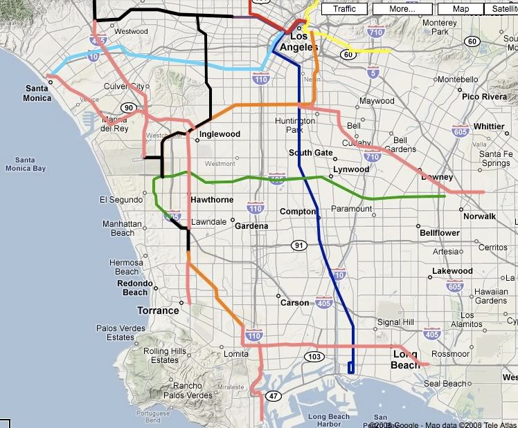 |
|
|
|
Post by Gokhan on Nov 29, 2008 16:50:48 GMT -8
V. Additional environmental issuesA. Abandon consideration of using the Right-of-Way between Manhattan Beach Blvd/ROW to Hawthorne/190th. Any passenger rail service in this section of the Harbor Subdivision should be placed in a tunnel or trench with cost-efficient trench stations in the middle of the wide Hawthorne Blvd right-of-way. Such a line would revitalize Hawthorne Blvd, generating higher ridership and creating a true opportunity for smart growth development and a thriving pedestrian oriented district. Comparatively, utilizing the right-of-way through this area would further damage a residential community composed of primarily single-family homes. If MTA continues consideration of this portion of right-of-way and ignores the obvious benefits of traveling under Hawthorne Blvd (benefits which most transportation agencies throughout the country recognize as crucial to the success of a rail transit system and vital to solving housing and economic challenges), the portion of the right-of-way should be trenched or in a tunnel. B. Below grade alignments (trench, cut-and-cover and/or bored tunnels) in all directly adjacent residential communities should be considered and followed through all environmental review phases. C. Environmental justice Future project meetings should be held in the heart of the environmental justice residential communities that will be most impacted by the decisions made, specifically, the communities of South LA, Inglewood, and Huntington Park. The neighborhood councils, and active block clubs and homeowners associations should receive personal presentations. There goes the "NIMBY opportunist" again. I wonder if he has his lawyers already working on this. |
|
|
|
Post by Gokhan on Nov 29, 2008 16:51:27 GMT -8
Hi Bart and Jerard,
Since this is now an official project, in fact the biggest rail project in study, could we make a new thread on the home page and move these threads there?
|
|
|
|
Post by Gokhan on Nov 29, 2008 19:05:25 GMT -8
The South Bay is crisscrossed with active and defunct rights-of-way. Some of them are freight rights-of-way, and some of them are Pacific Electric freight/passenger rights-of-way. On Google Earth I traced the Harbor Subdivision in blue, which is an active freight right-of-way. On the same map, I traced other active rights-of-way in red. Finally I traced the defunct Pacific Electric rights-of-way in light blue. Note that other active rights-of-way are already traced by Google Earth in black. Google Earth also shows all the Metro and Metrolink rail lines. 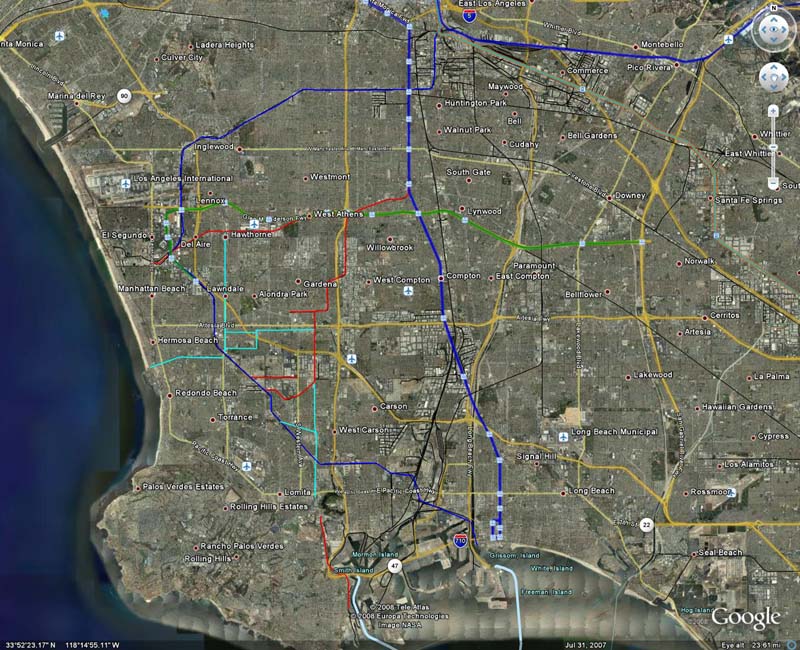 High resolution High resolutionNote that Hawthorne Blvd mentioned earlier in the thread used to be a Pacific Electric right-of-way. That's why it's so wide. This and the other Pacific Electric rights-of-way are traced in light blue as I already mentioned. Most of these Pacific Electric rights-of-way are preserved, some of them as vegetable gardens. In order to see the active Metro, Metrolink, and freight lines traced by Google Earth, you must check the Transportation box under Places of Interest. |
|
|
|
Post by JerardWright on Dec 31, 2008 13:57:33 GMT -8
How did London’s underground start, think of the Regional Connector. The German systems emphasize that on the outer areas of their at-grade LRT with a central dense subway through the main boulevard of the CBD, (Again think Regional Connector and Wilshire Subway) you will notice a pattern.
Utilizing the existing right of way on the South End has always been for LRT, however with the connections between the Cruise Center in San Pedro and LAX, a high-speed Metrolink style service becomes a credible option for Metrolink style rail.
Dare we consider an option for a minimum of 3-4 tracks two for LRT and one or two for freight/Metrolink heavy rail along the Southern ROW section from San Pedro to South Bay Galleria? That would create plenty of regional high-speed and local transit options for that corridor. Also the 405 corridor combined with the sub centers linked along the line LAX, Fox Hills, West LA, Westwood, Sherman Oaks would be a better candidate corridor for such a flexible high capacity system considering the Light Rail for Expo and the Light Rail on the Green Line.
Something to consider with this solution is; whether or not it really needs to go to Norwalk? Will we be duplicating the Green Line to the point of extinction and irrelevance? Should that line fully follow the Randolph Street Corridor and go to Whittier via Pico Rivera/Bell Gardens. Why not have this corridor run as a grid of Atlantic and 605 transit corridors running north-south to offset the East-west of the Green Line and Randolph? Also using the Firestone branch as the same potential for Metrolink service linking the heart of Downey, South Gate and Huntington Park linking that to longer distance trips.
The ROW on Centinela east of La Cienega doesn’t follow the trip generators of that community. It is geared South and South west toward LAX and Downtown Inglewood at La Brea not Centinela/Florence. With that it could interline with the La Brea/Hawthorne Line, so why even include this branch for consideration? Better still the section from Fox Hills south to LAX can be served through Ladera Heights again better linking these communities to the jobs in the region.
Will the City of Lawndale object to an open cut-trench station(s) down the middle of Hawthorne Blvd, how about Subway tunnels and stations? Also the combining of this corridor with Marina/Lincoln branch would provide a better connective network.
This interlining concept would work better on a corridor like the 405 because it’s longer trip distances and overall route structure. The 405 Corridor will currently has trip generators such as Sherman Oaks, Westwood, West LA, Fox Hills/Howard Hughes, LAX linked together that will require high frequency of service compared to the outer portions like Sylmar, Granada Hills, Panorama City to the North and Torrance, South Bay, Carson, Long Beach in the South. The south corridor portion from LAX to San Pedro/Harbor City is a perfect example of this fact.
It’s the mode of service that will determine that. If Metrolink operates under this condition with its 6 to 8 car bi level train coaches and Electric Locomotives this would be more than double the capacity of the line without needing the train to clear the crossings every minute. Also if the corridor is of longer regional trips, let’s say Lancaster to Inglewood or El Segundo to Glendale trip then Metrolink would benefit from this corridor. The number of branch switches along this corridor would limit how many trains run through. Too many branch switches will limit throughput capacity.
Interlining with branch-trunk networks has benefits, but it also has drawbacks. If the central trunk corridor isn’t active now nor in the future you’re basically spending money down a bottomless pit to nowhere.
Compared with Wilshire Corridor, Downtown Regional Connector or a much stronger candidate, the 405; Where are the trip generators along the Harbor Subdivision that will need access from both ends that wouldn’t be served by Crenshaw Corridor? Right now I only see 2 and they are on the southern end at Inglewood and LAX, maybe Vermont with a load of coordination between CRA/City of LA and Metro.
For South LA a grid of these services would do a better job of distributing the network, because it is already in a grid. Maybe this interlining concept would work better on a corridor like the 405 because it’s longer trip distances and overall route structure. The 405 Corridor will currently has trip generators such as Sherman Oaks, Westwood, West LA, Fox Hills/Howard Hughes, LAX linked together that will require high frequency of service compared to the outer portions like Sylmar, Granada Hills, Panorama City to the North and Torrance, South Bay, Carson, Long Beach in the South. The south corridor portion from LAX to San Pedro/Harbor City is a perfect example of this fact due to the greater spacing between centers.
No argument out of me on that one. However many rail systems have a large amount of rolling stock of varied designs and operation due to things over time. Wanting a homogenization of vehicle equipment is an exception not the rule.
Those folks around Downey and Whittier should be stark raving mad and ready to call their lawyers because the Orange County Metrolink line doesn’t stop there. Or residents in Glendale should sue HSR because a HSR stop isn’t included.
Metrolink style service will be needed more for the very reasons you’re arguing against. This added with Crenshaw Corridor creates the very trunk-feeder lines needed
For providing the connection to Union Station via the current freight/railroad tracks Metrolink would simply operate along that right-of-way and not need its own dedicated rail, like LRT would due to Federal Freight/heavy rail sharing. However if we have those third and four tracks for Light rail mode and the Metrolink style stop spacing is what is needed, Metrolink actually makes a good option to study as well in conjunction to LRT, so you’ve basically argued Metrolink in, based on your own analysis.
One location Western/Slauson would have no choice but to grade separate because it’s like the Flower/Expo grade separation, the trains are turning near an intersection it’s easier to grade separate the trains then it is to grade separate the intersection. Metrolink has a greater network of available heavy rail freight/commuter corridors to work from compared to LRT so based on that argument Metrolink has a great potential for improved long distance access and travel between many dense urban communities, similar to Metra in Chicago, which makes that mode an option for further study.
Which would strengthen the case to include Metrolink style rail in the analysis because of this flexibility. [/color]
Talk to the City of Lawndale on that about using Hawthorne Blvd, you are in part of their city. That is what essentially killed that proposal. I’ll check with my contact from the South Bay COG’s. Also Hawthorne is wide but it’s also congested with traffic, so what room do you have to create these trench stations on Hawthorne Blvd? You’re better off leaving it at-grade with station platforms.
The Right-of-way has 6 grade crossings (half of them can be easily grade separated) and is better tailored to the park-ride and transit center that is located there now. Future development around South Bay Galleria is occurring around the Right of way not on Hawthorne due to it’s proximity to the 405 Freeway on/off ramps which limits Pedestrian oriented development. The fact that residential occurs along the portion of the right-of-way makes it easier to further intensify the density and make pedestrian oriented development thrive.
The old study to which you’re basing this one clearly made a note that the Hawthorne route option is just that, an option to the Harbor Subdivision ROW.
Two corridors can be interlined together to reduce the requirements of fully grade separated rail on Harbor Subdivision. Lincoln/Marina with La Brea/Hawthorne. Also the Gateway Cities branch connection via Alameda Corridor will make that alignment Metrolink style rail. So there are really only two transit technology options that should be studied; LRT and Metrolink Commuter Rail.
|
|
|
|
Post by bluelineshawn on Dec 31, 2008 15:02:41 GMT -8
This route has all kinds of grade crossings when it gets to Torrance. And the streets are crossed at an angle which means that often two streets have to stop to allow trains to pass. And compared to where all of our other light rail lines run there's much more traffic in Torrance. Grade crossings, freight traffic, car traffic, etc. This route seems to have lots of hurdles no matter which mode is chosen.
|
|
|
|
Post by James Fujita on Jan 1, 2009 10:18:03 GMT -8
This route has all kinds of grade crossings when it gets to Torrance. And the streets are crossed at an angle which means that often two streets have to stop to allow trains to pass. And compared to where all of our other light rail lines run there's much more traffic in Torrance. Grade crossings, freight traffic, car traffic, etc. This route seems to have lots of hurdles no matter which mode is chosen. it is a bit unfortunate that there are a lot of street crossings in Torrance. some parts of the route will probably have to be widened, and there may be some mitigation issues in some places. some people will probably want bridges built and underpasses constructed. (thank goodness that the Hawthorne, Prairie and Crenshaw crossings are all grade separated!) but, it certainly won't be the first time we've had to deal with these kinds of issues. just look at the Gold Line on Marmion Way and through South Pasadena, or the Expo Line at Dorsey High. as for having a lot of traffic to deal with, it seems to me that the best places to put rail lines should have a lot of traffic  |
|
|
|
Post by ieko on Jan 1, 2009 11:39:24 GMT -8
What I think is sort of a shame here is that it looks like it'd be very difficult to have the line go to Del Amo Mall, if we could get it there then we could probably get Torrance to build a transfer center (the Del Amo Mall Torrance Transit transfer center was destroyed when the mall was remodeled -- thus making transfering a complete nightmare for even the most transit savvy)
The most ideal way to do it would be to get it to turn south on to Hawthorne blvd. where it meets 190th street, but it seems like that would be quite hard to do if not impossible because of the way that street is configured. Anyway I thought it could go up Fashion Way at Del Amo Mall and then move towards Carson st. or even Sepulveda blvd. to rejoin the right-of-way.
|
|
|
|
Post by damiengoodmon on Jan 1, 2009 22:12:57 GMT -8
The illustrative examples are intended to centrally make two really simple to understand points:
1) Further expansion of the rail system is needed and eventually will occur
2) Several different branches or lines using the right-of-way are plausible and viable
Which led to my recommendation, in the introduction, which can be summarized as: "Don't be stupid and build on the corridor in a manner that jeopardizes possible and foreseeable expansion."
I don't pretend that there are any concrete plans or current vision that goes beyond an election cycle. I do assume what I know and can prove:
-Relatively medium-level residential density almost everywhere
-Increasing population growth
-Existing long-distance commutes
-Dispersed economic and population centers (far more distanced than any Metro area in America)
One can look at these facts individually and come to an inadequate solution that fails to address the needs presented by the others. Or one can look at them collectively, in which case the solutions appear differently.
I say we look at them collectively, and include in our evaluation our understanding of the successes of systems like BART and DC Metro, and act as though the past 145 years of public transportation advancement has taught us something, so we don't build lines that we'll need to completely rip out in 30 or 50 years, and/or will actually do very little to solve the traffic crisis in which name we build these big ticket projects.
|
|
|
|
Post by kenalpern on Jan 2, 2009 6:56:47 GMT -8
There will be many problems with this project--and any other project in the South Bay--in the years and decades to come, and anything beyond a Green Line extension to LAX, a Green Line extension to the South Bay Galleria Mall, and maaaaaaaaaaybe a Green Line extension to PCH via Hawthorne Blvd. will face incredible opposition.
Why? Because the previous freight train delays (prior to the Alameda Corridor opening) on this route that were up to 30-45 minutes left an indelibly negative imprint on the residents there. Certainly, Metrolink and especially LRT are different beasts altogether than freight trains, but the resistance would be huge and the desire for more rail service in the South Bay (compared to road improvements and 405 freeway on/offramp improvements) would be questionable.
Those of us who looked into this with Friends of the Green Line would tell you that even the Sierra Club leadership of the southern portion of the South Bay (Torrance, Palos Verdes) didn't even give a hoot about the Green Line extensions to either the Galleria or Del Amo Mall.
Yes, things have changed over the past five years...but it is still my strong belief that rail to the South Bay must be organic in nature. In other words, we need a Green Line to LAX and the Galleria mall (political and grassroots interest remains strong, especially in the more pro-transit northern portion of the South Bay), and then look around and reassess.
Similarly, interest in the second phase of the Expo Line will probably zoom up once the Expo Line reaches Culver City. Once rail becomes a reality instead of science fiction, people will reassess.
Inasmuch as I value the Harbor Subdivision ROW more than most in this region, because it enjoys incredible upside potential, it ranks with the Green Line to Norwalk connection (probably a subway, folks) as a valuable long-term project that MUST be delayed for 20 years to figure out how folks will achieve consensus for planning and funding.
|
|
|
|
Post by bluelineshawn on Jan 2, 2009 12:38:53 GMT -8
If the Crenshaw line uses the Harbor Sub in Inglewood as light rail (and that seems to be where it's headed) doesn't that pretty much eliminate any other mode from consideration?
I used to live in Torrance and Hermosa 15 years ago and while it doesn't look all that different, traffic is way up from those days. Probably because there are bottlenecks at all of the ramps for the 405 fwy much more so than in the past. But even with the increasing traffic I don't imagine that there would be much support for rail of any sort, especially if it's at grade. And class, race, crime, or whatever you want to call it would play a large part in that opposition.
|
|


