|
|
Post by Gokhan on Mar 23, 2009 12:39:54 GMT -8
This is the fundamental diagram of 2003 Metro grade-crossing policy for light-rail transit: 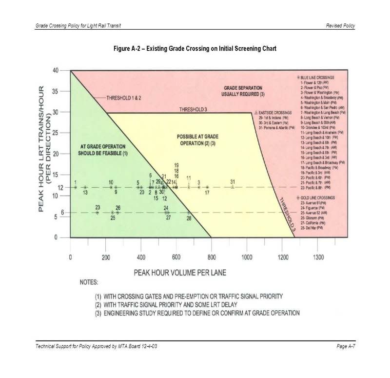 It plots the number of trains per hour per direction versus number of vehicles per hour per lane per direction at the peak period. It's divided into three regions: Green: At-grade usually allowedYellow: Possible at-grade operationRed: Grade separation usually requiredCrossing gates result in preemption for LRT, therefore no LRT delays at all. Moreover CPUC allows 55 MPH operations. Signal-controlled crossings result in at least some delay, more delay if there is no signal priority for LRT. Also, CPUC limits the LRT speed to 35 MPH. Grade separation, similar to crossing gates, also has no delays, and there is no CPUC speed limit, but usually 55 MPH is used for most LRT lines in LA. In Los Angeles and in particular for the Expo Line, there are 12 trains per hour (five-minute headways) per direction during the peak period. This results in: Green: Less than 550 vehicles per hour per lane per direction during peak period.Yellow: Between 550 and 1150 vehicles per hour per lane per direction during peak period.Red: More than 1150 vehicles per hour per lane per direction during peak period.The following are Expo's traffic counts at the crossings disputed by LADOT. The numbers are vehicles per lane per hour per direction during the peak period and the letters in parenthesis are levels of service during AM and PM peak periods, respectively, with A being the best and F being the worst. | 2030 no-build | 2030 with LRT and with additional lanes | | Overland | 1010 (C/D) | 751 (B/C) | | Westwood | 1260 (F/F) | 865 (B/B) | | Sepulveda | 970 (C/C) | 984 (D/C) | | Barrington | 900 (D/E) | 911 (D/E) | | Centinela | 1105 (C/B) | 900 (B/B) |
According to these numbers, all five crossings fall within yellow region, that is possible at-grade operation. But note that they require some additional traffic lanes. LADOT has recently sent their DEIR comments to the Expo Authority, opposing at-grade running and additional traffic lanes at these five crossings, asking for grade separation instead. I support gated, 55 MPH, at-grade operations at these crossings. LADOT should admit that they will be efficient and safe.PS: I had first interpreted the diagram above as gates cannot be used in the yellow region of the diagram. After sending this to Mr. Stephen Polechronis of DMJM/Harris, the head of the consultant team for Expo Authority, he called me and explained the 2003 Metro grade-crossing policy for LRT. It turns are that I was referring to the appendix, which has the previous studies but not the current 2003 policy. Therefore, the graph I was referring to as well as the other descriptions in the appendix were only background studies and they did not consider the advances in traffic-signal and LRT technology. He also told me that he checked with the author of the document to ensure that in the yellow region gates could be used, and the author was adamant that the gates could be used in the yellow region, as long as the further milestones, operational and safety, concludes that they can be used. And Expo Authority's further studies have concluded that gates can be used at these intersections on the Westside.
So, I thank Steve for promptly resolving this situation and properly informing me. That said, I'm supporting the gated, at-grade operations at these crossings, and I hope that LADOT can be convinced that these gated at-grade crossings will work safely and efficiently. |
|
|
|
Post by Transit Coalition on Mar 23, 2009 13:58:18 GMT -8
|
|
|
|
Post by Gokhan on Mar 23, 2009 16:34:02 GMT -8
From darrell's and SAUNDERS's posts at the Phase 1 grade crossings thread: Is the gist of this, that additional lanes generate additional traffic which would make the intersection eligible for grade separation? Basically they had issues even with the added lanes' capacity. Here's what LADOT's March 3, 2009 letter to Expo Authority said about the Overland Avenue crossing: LADOT modeled the crossing at Overland Avenue and the adjacent signalized intersection at Ashby Avenue, with an additional northbound and southbound lane. Even with these additional lanes, stopped traffic would exceed the storage between Ashby Avenue and the tracks (based on 95th percentile queues) northbound during the AM and PM peak periods, thus creating conflicts. Although your staff recently proposed a queue-cutter signal, it would be in the preemption mode regularly even when trains are not approaching. As a result, northbound traffic flow on Overland Avenue would be significantly impacted with long delays at the queue-cutter signal. In addition, traffic progression along Overland Avenue would be greatly diminished due to the extensive activation of the queue-cutter signal, with and without approaching trains. Our simulations indicate that northbound traffic would still queue to Coventry Place and block the intersection.
The at-grade proposal would deny daytime parking access to fronting residences along Overland Avenue in order to provide three lanes in each direction near the tracks. This would make it virtually impossible for residents to receive deliveries, visitors, and service calls, thus constituting a severe inconvenience.
Key Issue: Operational, safety, and parking problems for residents, arid light rail trains Actually in their statement, LADOT is admitting that Expo has already studied what they are contesting and they haven't made a real study themselves. Expo knows how to modify the signal at Ashby so that this will work, and they have found out that this doesn't have a significant effect on the traffic, rated only 751 cars/lane/hour and level of service B/C in 2030, which is pretty darn good. The parking argument is primarily for the sake of arguing. There are parking losses at various places along the alignment. The delivery trucks or guests can park in the driveways. |
|
|
|
Post by mattapoisett on Mar 23, 2009 17:44:53 GMT -8
I hope that LADOT can be convinced that these gated at-grade crossings will work safely and efficiently. [/b][/i][/quote] Could Someone Double Check how the Numbers were arrived at for the study. I remember a Phase 2 Environmental Planning Meeting where Someone asked about how the Vehicle Count was done for Overland. Metro's response was a vehicle count was done over two weekdays and one weekend day in 2007 and the dates given were in the summer when UCLA is out of session and people take vacations. Also the test area did not include the intersection of the 10 which is only 1/2 a mile away. That might account for the Low Numbers for Overland. Though I will say Traffic Does Ease up north of the 10. |
|
|
|
Post by darrell on Mar 23, 2009 18:55:37 GMT -8
Could Someone Double Check how the Numbers were arrived at for the study. I remember a Phase 2 Environmental Planning Meeting where Someone asked about how the Vehicle Count was done for Overland. Metro's response was a vehicle count was done over two weekdays and one weekend day in 2007 and the dates given were in the summer when UCLA is out of session and people take vacations. Also the test area did not include the intersection of the 10 which is only 1/2 a mile away. That might account for the Low Numbers for Overland. Though I will say Traffic Does Ease up north of the 10. Figure 3.2-1, the map of studied intersections, shows Overland five intersections studied from Ashby down to National, including the I-10 freeway ramps. On vehicle counts, page 3.2-6 states: Detailed weekday AM peak period (7:00 a.m. to 9:00 a.m.) and PM peak period (4:00 p.m. to 6:00 p.m.) traffic counts were collected at the eighty-six intersections during April, September, October, and November of 2007 and some additional traffic counts were conducted in February of 2008. Traffic count sheets are included in Appendix A of the Transportation/Traffic Technical Background Report for this DEIR. |
|
|
|
Post by mattapoisett on Mar 23, 2009 21:23:11 GMT -8
Figure 3.2-1, the map of studied intersections, shows Overland five intersections studied from Ashby down to National, including the I-10 freeway ramps. On vehicle counts, page 3.2-6 states: Detailed weekday AM peak period (7:00 a.m. to 9:00 a.m.) and PM peak period (4:00 p.m. to 6:00 p.m.) traffic counts were collected at the eighty-six intersections during April, September, October, and November of 2007 and some additional traffic counts were conducted in February of 2008. Traffic count sheets are included in Appendix A of the Transportation/Traffic Technical Background Report for this DEIR. Thanks For this Darrell But I am Having Trouble finding the Appendix A of the Transportation/Traffic Technical Background Report for the DEIR. which would say how often they counted at each intersection and the dates of the counts for each of the intersections. This would show how comprehensive the survey of the crossings were. |
|
|
|
Post by Gokhan on Mar 23, 2009 22:24:12 GMT -8
Thanks For this Darrell But I am Having Trouble finding the Appendix A of the Transportation/Traffic Technical Background Report for the DEIR. It doesn't seem to be available online. It might be available in the library hardcopies. |
|
|
|
Post by Gokhan on Mar 23, 2009 22:29:48 GMT -8
This car commercial shows gated light-rail crossings are safe, fun, cool, romantic, among other things. Can anyone point to the location?  |
|
|
|
Post by tonyw79sfv on Mar 23, 2009 23:19:33 GMT -8
Looks like the access road to the Gold Line maintenance yard with the North Broadway LA River bridge in the background as shown here; although I find it difficult to see where out of the widescreen frame the Gold Line viaduct is. This car commercial shows gated light-rail crossings are safe, fun, cool, romantic, among other things. Can anyone point to the location? |
|
|
|
Post by Jason Saunders on Mar 24, 2009 11:01:05 GMT -8
I cut and past this from the Dorsey/farmdale Ped bridge thread because it's about grade separation. As I've said before, I was shocked to see that Metro's grade-crossing policy would allow at-grade crossings at Westwood, Sepulveda and Barrington. I was equally shocked to see no grade separation at Crenshaw and Vermont. These corridors have very heavy traffic for many hours of the day. Although I appreciate Metro's use of a policy that plays no favorites, I think it's a bit too lenient in terms of what kinds of crossings it allows to be at-grade. Metro is supposed to reduce traffic congestion, not create more of it. Its thresholds probably need to be adjusted. I very much agree with you, MC. Last night I spent some time looking at the phase1 SEIR traffic analysis available on Metro.net but not buildexpo.org . I was trying to find numbers for Crenshaw and Vermont to compare them to westside grade crossings in particular Overland (not yet approved for grade seperation) I'm afraid, I wasn't very successful as I wasn't sure how to plug the numbers into the Grade Crossing Policy Graph. They appear to be measuring different things. (sorry, I'm not being more precise. I'm in a hurry and don't have time to look it up again.) My personal observation particularly at Vermont is that traffic is pretty bad there. Last week, I took the below photograph of the traffic backed up more then two blocks in BOTH direction while the automobiles queed for the Exposition traffic signal. As I observed the backlog cars waiting I found myself wondering why this intersection was not grade separated but Overland would be "considered." Please don't misinterpret my thoughts. I believe the alignment should be grade separated to the greatest extent practicle even if it's not in my neighborhood in the central part of town. All the heavy westside streets should be grade seperated and I agree the bar is set pretty high.  This second images is fuzzy but it shows the traffic backed up significantly.  |
|
|
|
Post by kenalpern on Mar 24, 2009 11:43:21 GMT -8
One nice thing (for the Westside, at least) about Expo Phase 1 being operational to at least
Crenshaw fairly soon is that we'll learn one way or another whether it's a big deal or not a big deal for streets like Vermont. Hopefully, it'll be no big deal--but if problems ensue, then I imagine the call for further grade separation will be even louder.
|
|
|
|
Post by Gokhan on Mar 24, 2009 11:52:03 GMT -8
I was trying to find numbers for Crenshaw and Vermont to compare them to westside grade crossings in particular Overland (not yet approved for grade seperation) They are available in Chapter 3 of the Phase 1 FEIS/R available on Metro's Expo site. For Vermont SB count is 1356/2 lanes = 678 per lane in PM peak period. This is 2020; so, 2030 would be around 700. 2020 level of service without project is C/B, with project is D/D (Page 3.2-19). So, yes, this is worse than Overland since for Overland level of service is C/D without project and B/C with project; although count is slightly higher. But, yes, both Vermont and Overland still fall below the Metro grade-crossing-policy Milestone 1 threshold of around 1150 cars/lane (then they have to perform Milestone 2 and 3 operational and safety analysis), but Vermont is more congested than Overland as measured by level of service; so, it looks like there could be environmental-justice issues if Overland gets grade separation. This is exactly what Fix Expo is going after. They are dying for Overland to get grade-separated so that they could bring this up in a lawsuit. But the trains at Vermont would be going slower because of the station. Although, Overland has some gentle curve but the station is far there. But they wouldn't be coming to a full stop at Vermont since it's far-side split platform. People will also argue about Overland Elementary. Although, very few kids walk along Overland, and the freeway-ramp crossings a few blocks down are far more dangerous for the kids than a gated LRT crossing. |
|
|
|
Post by Gokhan on Mar 24, 2009 13:41:42 GMT -8
As I've said before, I was shocked to see that Metro's grade-crossing policy would allow at-grade crossings at Westwood, Sepulveda and Barrington. I was equally shocked to see no grade separation at Crenshaw and Vermont. It does seem likely that Overland and Sepulveda will be grade-separated in response to LADOT's comments on the Draft EIR. Less certain about Barrington and Centinela, where the issue is more about queuing across the tracks than traffic volume. This is especially a concern at gated high-speed crossings like Barrington and Centinela, where most fatalities happen, again, as stated in the Metro grade-crossing policy. To me grade separation at Overland would be mostly political, since it has the lightest traffic and best level of service among the five disputed crossings. The real safety issues are at 55 MPH Barrington and Centinela crossings, not the low-speed crossings of Sepulveda, Westwood, and Overland. But, unfortunately, there are affluent homewoners' associations and neighborhood councils in the Overland - Sepulveda area but not in the Barrington - Centinela area; so, Overland and Sepulveda are getting the very strong push from them. So, this is an environmental-justice issue as well. |
|
|
|
Post by darrell on Mar 24, 2009 14:09:32 GMT -8
Looks like the access road to the Gold Line maintenance yard with the North Broadway LA River bridge in the background as shown here; although I find it difficult to see where out of the widescreen frame the Gold Line viaduct is. It doesn't look to me like the bridge in the video is the one by the Gold Line yard (look at maps.live.com - birdseye view), and it appears that is a Blue Line train. So where is there a grade crossing on a track paralleling an old L.A. River bridge? No place I can think of on the Blue or Gold Lines. Did they push a train for the occasion? Or composite it into the shot? Can you see any catenary? The shot where the crossing gates rise could be looking north on Santa Fe Avenue through the 4th Place bridge, with the building at the 4th Street bridge and Santa Fe Avenue in the background. But no tracks are there. And the final scene looks like the 4th Street bridge, with diagonal of what I presume is a stairway. Here's that birds-eye view, with notes. What do you think? 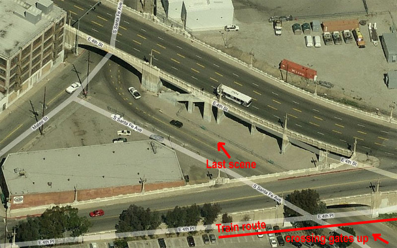 |
|
|
|
Post by spokker on Mar 24, 2009 14:36:47 GMT -8
The train looks like it was digitally inserted after the fact. It's appearance in the video does not look natural to me. It looks too flat. In fact, the interior shots from inside the cars look fake too, like there's a green screen effect going on.
|
|
|
|
Post by Gokhan on Mar 24, 2009 14:37:07 GMT -8
... and it appears that is a Blue Line train. So where is there a grade crossing on a track paralleling an old L.A. River bridge? No place I can think of on the Blue or Gold Lines. Did they push a train for the occasion? Or composite it into the shot? Can you see any catenary? The shot where the crossing gates rise could be looking north on Santa Fe Avenue through the 4th Place bridge, with the building at the 4th Street bridge and Santa Fe Avenue in the background. But no tracks are there. And the final scene looks like the 4th Street bridge, with diagonal of what I presume is a stairway. Here's that birds-eye view, with notes. What do you think? [/img][/quote] Thanks, Darrell! I'm amazed that you could recognize the location. I agree that it must be a composite with a Blue Line train. I don't see any catenary. It's still cool that they show light-rail trains in car commercials nowadays. |
|
|
|
Post by Gokhan on Mar 24, 2009 14:53:16 GMT -8
One nice thing (for the Westside, at least) about Expo Phase 1 being operational to at least Crenshaw fairly soon is that we'll learn one way or another whether it's a big deal or not a big deal for streets like Vermont. Hopefully, it'll be no big deal--but if problems ensue, then I imagine the call for further grade separation will be even louder. Unfortunately some people will pray for Expo Phase 1 accidents. I remember Mr. Clint Simmons saying at a meeting, "Ten kids will be killed every month." LOL |
|
|
|
Post by jejozwik on Mar 24, 2009 16:11:05 GMT -8
Unfortunately some people will pray for Expo Phase 1 accidents. I remember Mr. Clint Simmons saying at a meeting, "Ten kids will be killed every month." LOL well if that is the case we only need worry for the first year or so |
|
|
|
Post by joshuanickel on Mar 24, 2009 17:31:57 GMT -8
Looks like the access road to the Gold Line maintenance yard with the North Broadway LA River bridge in the background as shown here; although I find it difficult to see where out of the widescreen frame the Gold Line viaduct is. This car commercial shows gated light-rail crossings are safe, fun, cool, romantic, among other things. Can anyone point to the location? That is a blue line train in the commercial |
|
|
|
Post by bluelineshawn on Mar 24, 2009 20:07:13 GMT -8
I recognized the street as Santa Fe as well but noticed that there was no catenary and was going to suggest the train was pulled until it was pointed out that there aren't even tracks there. I guess that it must have been added digitally like was suggested.
There's another commercial out now, I think a car commercial as well, that shows LA light rail and trains from another agency. Canadian I think, but I only saw the commercial once. They intersperse the shots to make it seem like one city, but it's obviously not all LA.
|
|
|
|
Post by darrell on Mar 25, 2009 7:51:30 GMT -8
Did you notice how he's waiting at the crossing gates in the black SUV, facing north on Santa Fe, then the gates go up and she drives up even with him in the silver SUV, heading south?
But in the next (last) scene she drives off to the north in the silver SUV, leaving from a spot on the other side of the bridge.
In typical Hollywood location logic, not only do we have a light rail train that isn't there, but from one take to the next they've both moved the meeting place and turned it around in the opposite direction.
|
|
|
|
Post by damiengoodmon on Mar 26, 2009 23:09:30 GMT -8
This second images is fuzzy but it shows the traffic backed up significantly. Those aren't images of Vermont, they're images of Western. Here is a nationally recognized expert in traffic engineering and vehicular accident causation, Ed Ruszak, who submitted testimony before the CPUC regarding Western, which was not allowed, since the hearing was only on Harvard. He likely would have rendered similar opinions regarding Vermont, Crenshaw, Normandie and to a lesser extent Arlington if his scope of work included those intersections as well: The Harvard/Western crossing operation presently is a highly congested situation over many hours of the day in terms of vehicular, pedestrian and bus movements. This situation will be exacerbated and become even more dangerous with the operation of the Metro Line as presently proposed. This is because, as a practical matter, there just isn't enough time to accomodate all of the users. Accident potential will be very high due to a number of vehicle/train/pedestrian/bus conflicts, all within a confined intersection area. Simply each intersection needs time: time for pedestrians to cross an intersection (4 feet per second). Time to clear the left turning lanes. Time for through running, etc. There's no robbing Peter to pay Paul in Los Angeles, because there's no excess capacity at these streets. After the Expo project is completed, the intersection of Western/Exposition will expand from 4-phase operation to 8-phase operation with increased pedestrian and vehicle volume.
[....]
The future phasing will simply have to have longer cycles than the present phasing. It is not reasonable to think that the time for a 4-phase signal cycle with no train can be the same as the time for 8 phases with a train. There is only so much time that can be allocated for each signal phase to let cars, buses, pedestrians and the train through. I believe that the signal cycles will need to be extended to as long as 5 minutes during the 6 hours of peak operation because any lesser time will simply not allow the intersection to operate safely and efficiently. Furthermore, I think it is inevitable that the conflicts and violations of the signals, both by pedestrians and car drivers, will increase, thus greatly increasing the potential for accidents.
[....]
During the peak periods, using the future traffic and pedestrian volumes and the traffic signal phasing, I have estimated queue lengths on Western Ave. to be between 30 to 35 cars per lane. This means that during the peak periods (which will be at least one and one half to two hours in the morning, two hours in the afternoon and hour mid-day), not all vehicles will be able to clear the intersection at each signal cycle, creating backups. This will contribute to yellow and red light running, vehicles caught in the intersection blocking cross traffic - and the train - and increasing the potential for collisions. Ruszak describes present conditions at Western: The key present conditions are as follows:
-Present traffic conditions indicate peak periods of two hours during the morning 7:00-9:00 a.m., and three hours during the afternoon, 3:00 to 6:00 p.m.
-Vehicle volumes indicate levels of service LOS of E. In other words, this is at maximum capacity now. Any additional traffic will cause this intersection to fail, i.e., it cannot accommodate all the traffic attempting to move through.
-There are long vehicle queues (backups) in both directions along Western Ave., with northbound and southbound backups reaching up to 15 to 20 vehicles per lane per signal cycle during the morning, mid-day and afternoon peak hours.
-The backup lengthen even more for short periods when bus transit stops at the northeast and southwest corners.
-Pedestrians frequently cross on the flashing "DON'T WALK" signal and get stranded in the middle of the street. When the Expo line starts operating, there will not be enough time for pedestrians to cross safely.
-The present signal cycles to accommodate all the existing signal phases exceed 3 minutes in the afternoon peak periods and 2 minutes during the morning peak periods.
-There are no dedicated right turn lanes on any corner of the intersection. Cars waiting to turn right often block the right traffic lane while waiting for pedestrians to clear the intersection.
These are real observations of how the intersection operates. Simply saying that the densities of pedestrians can be accommodated based on a computer model and that the LOS is E or F does not adequately describe the real picture of the delay, chaos and safety issues that are present now at this intersection.
[....]
In lay terms, this intersection operates poorly with many vehiclce/vehicle conflicts and pedestrian/vehicle conflicts. Accidents are waiting to happen because the drivers do not want to stop and wait for perceived excessive time periods. They tend to use all of the yellow time to go through the intersection (and there is also moderate red light running). Pedestrians clog the sidewalk, walk on the "DON'T WALK" cycle and pedestrian crowding is worse when bus transit arrives and unloads passengers. Waiting bus transit patrons have little room for queues at the corners.
[....]
When the bus stops at these corners, especially on Western Ave., they block one of the two through lanes for upward of 45 seconds, depending on the loading and unloading time. This obviously impedes one of the high volume through lanes and has some drivers in the slow lane "cutting off" the through lane traffic to avoid being blocked by the bus. This adds to the sideswipe and rear end accident potential. Further, it adds to the congestion and delay at this location.
Finally, it is important to note that the Exposition Blvd. stop is currently only served by the Western local buses, not the 60-foot long Western limited-stop express buses (Rapid). With the operation of the Expo line, the 60-foot Rapid buses will now stop at Exposition Blvd. as well, increasing the number of buses, length of blockage, amount of delay, congestion, and potential for accidents.
[....]
Please see Exhibits 7-12. This was also taken on Wednesday, July 16, 2008 at approximately 7:30 a.m. These clips show a number of existing hazards - even without the Expo line:
-The intersection has very heavy congestion;
-The Volvo is stuck in the left turn pocket and blocking traffic;
-The red pickup truck is also stuck;
-Pedestrians are crossing Exposition Blvd. with the red light flashing;
-The pedestrian traffic is at maximum capacity crossing the intersection;
-Traffic southbound on Western Ave. is backed up for at least 25 cars, as far as the eye can see. It will take at least three cycles for the last car to clear the intersection.
This kind of congestion leads to frustration, anxiety and accidents. Future train passengers boarding to and disembarking from the trains will only exacerbate this situation. His entire testimony is rather easy to follow and breaks-down in laymen terms just how a heavily congested intersection is impacted by the implementation of a light rail crossing/system of this type. So how does MTA get away with this, and isn't the grade crossing policy supposed to eliminate circumstances like these? If you want to simply understand the issue with the grade crossing policy you have to begin with this really simple concept: The GCP, indeed the entire MTA light rail EIR process, is predisposed to creating more at-grade crossings not less. The burden is on proving at-grade operation is impossible, not on any objective assessment with concern for anything except the capital construction cost. Read the policy from cover to cover and this is totally clear. And by "impossible," I mean impossible to maintain service without significant service delays. The assumption is that at intersections with particularly high vehicle volume (measured not as overall volume, but per lane traffic volume), there is limited capacity to provide any preference for the train (too many cars need to keep moving), so as a result service would endure substantial delays. So the point is this: if MTA can get by without recognizing an impact so they can build at-grade crossings that make no sense they will. They will build it and fight with the traffic departments after the fact. (Also, keep in mind the department that plan the trains at MTA is a completely different department from that which operates the trains). Their calculations are based on future projected assumptions and measurements that they take. Ignore one or two important variables, measure at the wrong time of day, and it passes the threshold. Add that variable, or take it during another time of day, and it doesn't pass the arbitrarily high threshold. There are countless examples of this. The traffic counts for many intersections in the Phase 1 EIR were taken during the summer months, when school was out of session. You see that's why I always chuckle when the response to criticism of MTA's proposed operation is a statement like, "It was studied in the EIR and shows no impact." It is no coincidence that these type of statements almost always come from at-grade advocates. At-grade advocates, mind you, who very rarely disclose they have a personal disposition for at-grade crossings, in large part because their reasoning for preferring at-grade crossings is very very weak. I chuckle because statements like those rely on a sort of ignorance of the listener. If the listener thinks EIRs are conducted by credible/neutral third parties, who have the authority to say "No we're not doing this project" if an impact is considered too great, then the credibility of the EIR would be much stronger. But the EIRs are done by MTA, an agency with a mandate to build, and build as quickly as they can. MTA is not LADOT. MTA is not CalTrans. MTA often fights with LADOT and CalTrans in the planning and operation of light rail lines. (Again, recognize the goal of Metro is a fight for more priority for trains, everything else be damned). There are several intersections along Phase 1 where LADOT and CalTrans voiced strong objections and rolled over for a variety of political reasons. Ignoring the very political process of rail expansion in Los Angeles is a disservice to those who are truly committed to rail transit exactly for the primary reasons these projects are sold to the public. If it was politics for the sake of better transit, conducted by politicians who actually care to see our situation improved I might stomach it. But that's not the case. I am grateful however that we now have the internet, so that 30 years from now, after billions have been lost in the economy from the REAL cost of at-grade crossings, we'll have documents showing the role some politicians played in wasting tax payer dollars building inadequate systems. Systems that will cost multiples times more to fix then, than it would cost to build right now. |
|
|
|
Post by Gokhan on Mar 27, 2009 7:27:20 GMT -8
Those aren't images of Vermont, they're images of Western. Western Ave is nowhere near the Metro grade-crossing criteria and doesn't deserve grade separation under this criteria. The 2020-projected vehicle count is only 1121/2 = 561 vehicles/lane/hour and the level of service in 2020 will only change from C/B with no LRT to C/C with LRT, for AM/PM respectively. On the other hand, Flower/Exposition was also nowhere near the Metro criteria but got grade-separated solely under the pressure from LADOT, who are the dictators of the auto culture. As a result lots of time and money was spent to build the USC trench and a future Expo - Blue Connector has almost been precluded. Recent history might repeat and the character of the green single-family residential neighborhood between Overland and Sepulveda might be ruined forever with ramps, retaining walls, aerial guideways, and rail bridges under pressure from LADOT. |
|
|
|
Post by LAofAnaheim on Mar 27, 2009 10:10:18 GMT -8
Recent history might repeat and the character of the green single-family residential neighborhood between Overland and Sepulveda might be ruined forever with ramps, retaining walls, aerial guideways, and rail bridges under pressure from LADOT. I don't like the auto culture dominated by the LADOT, but if that's the case, then hallelujah! Good job LADOT! You think it would be smart to have Flower/Expo at-grade considering the proximity to the I-110 on and off ramps? Would you not expect delays to the Expo Line trains? I always keep saying we need to avoid a Mariam Way situation, but look at the Blue Line on Washington Blvd. We don't want more of those segments either and that's what could have happeend here. By the way...all those negative effects you say (aerial guideways, retaining walls, etc..) aren't those already done for feeway building? Can we not build rail as equally as freeways? I'd rather have an aerial structure with fast speeds than at-grade and worry about accidents delaying your journey. Don't worry..I know there's always maintenance issues that can cause delays, but that's a moot point for ALL rail lines in the world. |
|
|
|
Post by darrell on Mar 27, 2009 11:50:34 GMT -8
What would those 8 phases be? I count only 4-6, confirmed by James Okazaki, that there are no train-only phases, trains will go during the through-green phases on Exposition.
|
|
|
|
Post by Gokhan on Mar 27, 2009 13:42:22 GMT -8
Recent history might repeat and the character of the green single-family residential neighborhood between Overland and Sepulveda might be ruined forever with ramps, retaining walls, aerial guideways, and rail bridges under pressure from LADOT. I don't like the auto culture dominated by the LADOT, but if that's the case, then hallelujah! Good job LADOT! You think it would be smart to have Flower/Expo at-grade considering the proximity to the I-110 on and off ramps? Would you not expect delays to the Expo Line trains? I always keep saying we need to avoid a Mariam Way situation, but look at the Blue Line on Washington Blvd. We don't want more of those segments either and that's what could have happeend here. By the way...all those negative effects you say (aerial guideways, retaining walls, etc..) aren't those already done for feeway building? Can we not build rail as equally as freeways? I'd rather have an aerial structure with fast speeds than at-grade and worry about accidents delaying your journey. Don't worry..I know there's always maintenance issues that can cause delays, but that's a moot point for ALL rail lines in the world. Flower St is a one-way street and there is plenty of queuing space (more than a signal-phase-full) on the freeway off ramp. Given these conditions at-grade alignment with the existing signals would work perfectly there. There is no on ramp there either -- remember that Exposition Blvd South and North are also one-way streets -- no interference with LRT at all. Nowadays you can't build elevated freeways (or freeways period) in LA either. Look what is happening with the I-710 extension. They will spend $10 billion to build it underground. What you are talking about was built in the 60s. That's when they got rid of the LRT and built the freeways. Gold Line Marmion Way is only a minute delay, and it's life. Years ago someone sold part of the right-of-way and they built those houses there and you can't simply acquire them now to widen the right-of-way. It's not cost-effective to take the line below grade there for only a minute of gain either. That's the nice thing about LRT -- it can have mix operations and I like the pedestrian mall at Marmion Way. As you said occasional grade-crossing accidents doesn't matter because more frequent than that are breakdowns. Of course, if studies find out that grade separation is necessary, then it's a different story. LRT, as a general rule, is built at-grade and grade separation is provided only where necessary. Otherwise, it wouldn't be LRT but it would be HRT. That's not the scope of the Expo Line. |
|
|
|
Post by metrocenter on Mar 27, 2009 16:14:51 GMT -8
This second images is fuzzy but it shows the traffic backed up significantly. That was SAUNDERS, not me. Don't attribute things to me that I didn't post. |
|
|
|
Post by Jason Saunders on Mar 27, 2009 17:10:05 GMT -8
That was SAUNDERS, not me. Don't attribute things to me that I didn't post. Hey guys, I'm sorry for the confusion. I was out on my Bicycle that day riding the length of phase one taking photographs all up and down the alignment. I'm sorry if I was mistaken in my street identification however our conversation regarding Vermont is still valid. In any case traffic is pretty bad at all those intersections. |
|
|
|
Post by darrell on Apr 25, 2009 23:15:39 GMT -8
(Cross-posting this here and on the Foothill Extension thread.) I found the application of the Metro Grade Crossing Policy to the Gold Line Foothill Extension in the FEIR section 3-15, Traffic worthwhile to compare with Expo phase 2. Expo is not unique in working out mitigations in the gray pale yellow area between thresholds. Beginning on page 3-15-80, Of the 40 proposed grade crossings, the Milestone 1 screening indicated that there were no grade crossings where grade separation would usually be required and there were 29 crossings where operation should be feasible at grade. With respect to the 11 remaining locations, 5 were clearly exceeding the threshold 1 & 2 line therefore requiring a Milestone 2 analysis to confirm “possible at grade operation” and the remaining six were straddling the threshold between “at grade operation should be feasible” and “possible at grade operation”. Therefore, a total of 11 crossings were analyzed using the Milestone 2 procedures to verify whether operation at grade would be possible. Only one new grade separation will be provided, at Santa Anita Avenue, paid for by the City of Arcadia. Continuing on page 3-15-82, Detailed Analysis Reports (Milestone 2 Analysis) were completed for each crossing identified in the “Possible At-Grade Operation” region, as well as those that were in the border line region between the “At Grade Should be Feasible” category and the “Possible At-Grade Operation” category. Utilizing several checks on rail operations, traffic operations, and safety, feasible mitigations and crossing treatments for these 11 crossings were identified. Table 3-15.23 outlines the treatments that would allow these crossings to be operable at grade. For example, at Myrtle Avenue in Monrovia the Recommended Treatment for At-Grade Operation is: Four quadrant gates.
Provide pedestrian gates.
Provide pre-emption of the traffic signal.
Provide pre-signal.
Consider queue length detection and traffic signal interconnect between Duarte Avenue and Evergreen Ave.
Include traffic signal provisions to address queues.
Add no right turn on red sign |
|
|
|
Post by Gokhan on Apr 26, 2009 2:51:59 GMT -8
^^
So, basically every crossing was determined to be at-grade and no one complained? Is that part of the County actually part of the heaven? No Fix Foothill? No opposition from the Foot Hills Homeowners' Association? Not even a bit?
So, I guess all the CAVEs, NIMBYs, zombies, etc. were sent to west of Downtown by forces of nature. If the east is heaven, the west must be naturally the hell.
And don't get started on that South LA and the Westside are more congested than the Foothill area. I know how congested the roads leading to I-210 are. The last time I was there it took me two hours to drive four blocks.
Perhaps the Cheviot Hills Homeowners' Association can pay for the tunnel under Overland and Westwood they are asking for like Arcadia -- $100m/1,000 homes = $100k/home. Just bill it to their homeowners' dues. (PS: Currently CHHOA homeowners' dues are about $50 [50 bucks] a year and many don't pay it. You can't become rich if you are not tight, can you?)
|
|