|
|
Post by mattapoisett on Jul 10, 2007 17:54:22 GMT -8
Friends 4 Expo posted a note about additional alternatives being considered by the LACMTA for phase 2 of Expo. While I'm a strong Proponent of the Exposition ROW, some of these have me intrigued. I for one would like to see the Culver Blvd ROW studied since it most of the Row still exists like the Exposition ROW and it has the Playa Vista Development at the end [along with Marina Del Rey] of it which might be able to support the line. Plus, if it went on Culver it would be much closer to my apartment than it is now. www.friends4expo.org/news.htm"6/7/07 – The Construction Authority announced additional alternatives from the Scoping process to be assessed for their effectiveness, environmental impacts, cost, and transit supportive land use: LRT on Venice Blvd. to Venice Beach LRT on Venice Blvd. to Lincoln Blvd. in Santa Monica A network of LRT services branching out on Culver Blvd., Washington Blvd., Pico Blvd., and Santa Monica Blvd. LRT on streets other than Venice including Culver Blvd., Washington Blvd., Pico Blvd., and Santa Monica Blvd. Monorail on the Exposition Right-of-Way or Venice/Sepulveda Personal Rapid Transit (PRT) on the Exposition Right-of-Way and Venice/Sepulveda Following initial screening, the Expo Board will determine (with FTA concurrence) the final alternatives to be included in the full environmental review process, including grade separations per the MTA Grade Crossing Policy. We expect this late summer or early fall, 2007." buildexpo.org/images/Items/2007/06_June/20070607EXPOITEM5.c.pdf |
|
|
|
Post by kenalpern on Jul 10, 2007 23:15:54 GMT -8
I concur. I hope that the Major Investment Study (MIS) that Bill Rosendahl is promoting for his Westside Rail Network explores the Venice and Culver ROW's as future spurs of the Expo Line. After all, there's a reason why Venice and Robertson, where they all come together, was called Culver Junction during the Red Car days!
|
|
|
|
Post by wad on Jul 11, 2007 23:49:43 GMT -8
Culver should be taken off the table. The bus line serving it was slated for cancellation, and was only saved because Culver CityBus stepped up to take over part of the route.
The right of way is there, but there is very limited potential, even for local bus service. Let this sleeping dog lie.
I like the network idea, with a few lines fanning out. The line should stay on the right of way, especially through Cheviot Hills. However, running along Pico does make sense. And when money becomes available, Expo can have a Venice spur.
|
|
joequality
Junior Member
 Bitte, ein Bit!
Posts: 88
|
Post by joequality on Jul 12, 2007 8:12:36 GMT -8
Monorail and PRT... good lord...
maybe if those were everywhere it would look like something straight out of Minority Report
|
|
|
|
Post by BRinSM on Jan 16, 2008 8:18:41 GMT -8
Question regarding the use of the ROW in phase II:
Does the MTA own the whole ROW from Cheviot Hills into Santa Monica? I noticed on Google maps that much of the ROW is being used as parking and storage for nearby businesses. When the phase II is to be built, can the MTA just force these businesses off the ROW or will they need to purchase the property in order to do this?
|
|
|
|
Post by Tony Fernandez on Jan 16, 2008 8:26:27 GMT -8
They have it purchased to 14th street. There are various proposals for Colorado at that point, but most likely it will run at-grade.
|
|
|
|
Post by Tony Fernandez on Jan 16, 2008 8:33:50 GMT -8
Also, Venice definitely needs to be studied, it goes through a ton of density, and Culver has some density, but it shouldn't be built yet. I'm going on a limb here and saying that the Culver bus line either didn't go downtown or was too slow. Either way, a light-rail line could fix that, and Playa Vista needs some mass transit near it. Imagine what would happen to Culver City if another Culver Junction was made.
Also, I forgot to mention this, but if ridership on the Culver Line would be low, then the Crenshaw Line probably needs to be completed to get the jobs on Wilshire as part of the destinations.
|
|
|
|
Post by damiengoodmon on Jan 16, 2008 10:16:51 GMT -8
Venice isn't being studied, because according to Expo Authority staff Venice Blvd with it's 25 foot parkways on BOTH sides of the street, two bike lanes, and grassy median isn't wide enough to fit light rail at-grade. (Yet Expo Blvd from Arlington to Vermont, with it's 6 foot sidewalks and 25 foot median is big enough for two tracks AND two bike lanes.  ) Go to the BuildExpo.org website and you'll see that staff said that significant property takes would be necessary down Venice if built at-grade, and thus only studied the elevated option (which made it far more expensive - altering all cost-benefit calculations). When I asked for that information they refused to supply it. I'm not saying I'm for the Venice diversion, though I do support study of a branch line. And when that branch line comes I can't see how it can be supported at-grade. I'm just highlighting this as a clear example of the type of lies and half lies the Expo Authority staff constantly present, which do nothing but add fuel to an already adversarial relationship with the community, and harm public transit expansion and advocacy throughout the region. How can people trust an agency, and advocate for expansion of rail by that agency, if said agency constantly presents blatant lies and miscalculations. Here's the chain of emails: Email from Me to Expo Authority on 11.17.07Dear Mr. Steve Polechronis,
I have reviewed the Expo Phase 2 Alternatives Analysis Presentation pdf on the BuildExpo.org website and have a few presentation specific and related questions:
1) On slides 26-28, do each of the properties highlighted in aqua represent properties that would require full or partial acquisition to operate the Venice Beach alignment at-grade?
2) Do you have a list of the properties (with their addresses) that would require full acquisition with an at-grade alignment from Venice to Venice Beach?
3) Do you have a list of the properties (with their addresses) that would require partial acquisition with an at-grade alignment from Venice to Venice Beach?
4) On slide 36, are the projected project boardings the additional rides expected in the forecast year from the phase 2 project?
5) Given that the phase 1 2020 projections for ridership is 43400, and the statistic listed on slide 36 for the ROW route is 41400, is it your prediction that ridership for the full Expo Line from Downtown LA to Santa Monica via the ROW would be at least 84700 in the phase 2 forecast year?
6) What is the forecast year for the project?
Please respond by the close of business Monday, November 19th with a date I can expect answers to these questions.
Thank you,
Damien Goodmon There are specific reasons I asked each and every one of these questions, and I've made it known, on the record at their board meetings. Here's how Expo Authority responded to Me on 11/30/07: Dear Mr. Goodmon,
Thank you for your interest in Phase 2 of the Expo Line project. Your questions will be addressed in the Draft Environmental Impact Statement/Environmental Impact Report (DEIS/DEIR).
For the latest Phase 2 project information, please visit our website at www.buildexpo.org/phase2_overview.php.
Regards,
Gaby Gonzalez Here's my response on 11/30/07, which I have yet to receive answers: Ms. Gonzalez:
My questions were in reference to the document that you have posted on your site (pdf) and results that you presented to the public in meetings on 10/22, 10/24, and 10/25. This information was used to make staff recommendations to the Expo Authority Board of Directors to help them determine which routes to eliminate from further exploration in this EIS/EIR process. The Expo Authority Board of Directors acted on these recommendations at the November 1, 2007 Expo Authority Board meeting, where they eliminated from further consideration in this EIS/EIR process routes that were advocated for by a substantial number of members of the public.
I've asked basic and specific questions about this information. Is there a particular reason this information, which again, was used to help elected officials eliminate from further study in this EIS/EIR process routes advocated by the public, is not now available to the public?
Your prompt response is greatly appreciated.
Sincerely,
Damien Goodmon They know the Venice-Sepulveda hump violates environmental justice laws (as was explained years ago by the EPA) so without studing of the Venice Beach route that only leaves the ROW. |
|
|
|
Post by jejozwik on Jan 16, 2008 14:41:24 GMT -8
so wait, am i hearing this correctly? phase 2 will be at grade?
this is the second time i've heard something like this. the first was that the city of santa monica wanted the last stop at grade to encourage window shopping and a more ped-friendly atmosphere. but i thought for sure everything up to that point would be elevated.
please correct me
|
|
|
|
Post by Tony Fernandez on Jan 16, 2008 15:21:29 GMT -8
Everything in phase II is using the ROW (hopefully) and will be at grade, save for at a few busy arterials.
|
|
|
|
Post by BRinSM on Jan 16, 2008 16:49:57 GMT -8
So the parking and storage space that the ROW is currently being used for will be eliminated? Hopefully there's no issues with the local businesses and potential long term leases they may have for that land with the MTA.
|
|
|
|
Post by Tony Fernandez on Jan 16, 2008 19:01:23 GMT -8
The MTA owns that land, they know that it's coming, so it's no surprise.
|
|
|
|
Post by whitmanlam on Jan 16, 2008 22:18:22 GMT -8
Everything in phase II is using the ROW (hopefully) and will be at grade, save for at a few busy arterials. Most of it phase II would use the ROW but would need some grade separated crossings in the ultrasensitive Cheviot area. And possibly an underground section in Downtown Santa Monica as the area is too dense. We are a long ways from funding these projects or even paying for current projects. Hopefully MTA can get some funds from somewhere, sales tax if need be. A Venice LRT spur might be too much, I would favor a street car track making a loop on Venice, Pacific, Washington St. , and Lincoln. |
|
|
|
Post by antonio on Jan 17, 2008 1:12:44 GMT -8
Damien, how does the Venice-Sepulveda option violate environmental justice laws? I certainly understand your case and beef with Phase 1 but what has the EPA said about it and how is it not viable and will that ensure that the ROW option is chosen? As for the properties on the ROW, the MTA has owned the land since the early 90's and any building on it would have been put up with the knowledge that the MTA planned to turn it into a rail line and therefore no sympathy should be extended to those business (they are mostly parking lots anyway, who need more cars). The fact that the line is at grade in this section should not be that disheartening. The ROW acts more like a true ROW ala Gold Line until it hits Olympic in that the majority of streets its crosses are arterials. Many of these arterials also have high traffic counts and would be grade separated and the ones that aren't would be gated enabling 55mph operation so the speed and efficiency of the line in this section should not be a worry until it gets to Colorado when it would run more like the phase 1 sections.
|
|
|
|
Post by kenalpern on Jan 17, 2008 1:31:40 GMT -8
I agree with pretty much all of Antonio's questions, concerns and conclusions, as just stated. There are several key arterials that will require grade separation because they meet the traffic count requirements of Metro grade separation. There is a relative dearth of north-south arterials in the Westside, so the few that exist (Bundy/Centinela, Sepulveda, Overland, etc.) are pretty congested and can't handle at-grade rail.
At Santa Monica, the Colorado portion will allow at-grade rail. Interesting how Santa Monica wants at-grade rail but Culver City and other regions want grade separation.
Anyway, I think the regrettably-charged atmosphere will force the Expo Authority to keep things very close to the vest to minimize the inevitable lawsuits that are pending, and to keep things from being misinterpreted either by the press, the community, or both.
|
|
|
|
Post by JerardWright on Jan 17, 2008 5:34:25 GMT -8
Damien, how does the Venice-Sepulveda option violate environmental justice laws? I certainly understand your case and beef with Phase 1 but what has the EPA said about it and how is it not viable and will that ensure that the ROW option is chosen? To start, because the Phase 1 portion never had such alternatives such as King Blvd running it at-grade or grade separated down King Blvd where as Cheviot Hills at either Right-of-way or Venice/Sepulveda option. As for the properties on the ROW, the MTA has owned the land since the early 90's and any building on it would have been put up with the knowledge that the MTA planned to turn it into a rail line and therefore no sympathy should be extended to those business (they are mostly parking lots anyway, who need more cars). The fact that the line is at grade in this section should not be that disheartening. The ROW acts more like a true ROW ala Gold Line until it hits Olympic in that the majority of streets its crosses are arterials. The ones in question for Phase 2 come from all the studies going back to 1994 had the following crossings studied as grade separated because of their proximities to freeway on/off ramps and or street geometry; * Palms/National/Motor (existing bridge) * Overland * Pico/Sawtelle/Gateway (Street geometry and proximity to the 405 off ramp) * Bundy (high traffic, ride the SM #10 to see what I mean) * Downtown Santa Monica How the right-of-way slices through the Westside at an acute angle or diagonally helps us because we can reach the destination faster than it would if where straight down a street and 90 degree turns. |
|
|
|
Post by darrell on Mar 7, 2008 18:04:59 GMT -8
The Expo Authority has just scheduled new phase 2 workshops:Greetings— The Exposition Construction Authority invites you to attend the upcoming Phase 2 Community Workshops. At these Open House style meetings, we will have various stations that provide information on grade crossings, station and parking locations, bike routes and more: · Wednesday, March 26, 6:30 pm, Webster Middle School · Tuesday, April 1, 6:30 pm, Crossroads School · Thursday, April 3, 6:30 pm, Vista Del Mar Child and Family Services Please see attached notice [pdf] for further details and forward it to area stakeholders that might be interested. We look forward to seeing you and hearing your comments. Should you have any questions, I can be reached at 213-243-5535 or e-mailed at ggonzalez@exporail.net. Kind regards, Gaby Gonzalez Government/Community Relations Representative Exposition Construction Authority 707 Wilshire Blvd., 34th Floor Los Angeles, CA 90017 Tel. 213-243-5535 Fax 213-243-5553
|
|
|
|
Post by darrell on Mar 9, 2008 22:11:26 GMT -8
Which is total B.S. because Venice Blvd has the benefit of parkways that in most (but admittedly not all) portions measure 20-25 feet EACH. That's 40-50 feet of extra ROW where in most portions only 25 is needed. The point of course is if it can be jammed into Expo between Arlington and Figueroa (ALONG WITH 2 bike lanes) with its 5-8 foot sidewalks, it should have been evaluated down Venice as part of the Phase 2 study. Along with the fact that it harms the credibility of the engineers, and breads contempt from the public when they just off the bat claim B.S. like its not feasible without taking a lane. You along with most other people in this forum has seen the Expo Authority's esponse to my request for the properties they claim would need to be taken to fit it within the ROW if the line were built at-grade. They simply refused to supply them. (Transferred from Eastside Extension - Construction Update thread) The standard clearance width for double track with center poles is 30 feet (tracks 14 feet on center), so 15 feet would be needed on each side. Slides 22 and 23 of last fall's presentation show a Public ROW increase from 130 feet to only 148 feet, just 9 feet on each side, so they do not appear to propose retaining current parkway widths. Parts of Venice are wide enough. As you agree, others aren't, especially from Sepulveda to Westwood, around Overland, and Cardiff to Robertson. Then there's lost front parking that would have to be mitigated. Intense traffic around Sepulveda and Culver-Robertson would probably require grade separation as well. It "harms the credibility of the engineers, and breads [sic] contempt from the public" that they know how jammed traffic is on Venice Blvd., especially around Culver-Robertson, and don't propose removing traffic lanes? It was evaluated without taking lanes. The preliminary totals from last fall were 39 full and 86 partial property takes for the Venice/Sepulveda route option. It wouldn't be that hard to estimate which ones from parcel maps and aerial photos. There may be a legal reason not to specify parcels until the final list is presented in the Draft EIS/EIR. Are you advocating the Venice/Sepulveda route option? |
|
|
|
Post by darrell on Mar 26, 2008 21:13:52 GMT -8
From the Expo phase 2 meeting tonight, here are the station locations and grade crossings / separations proposed so far, from east to west. "Future Action" crossings - like Overland - should be finished in another month or so.
The Venice-Sepulveda option would have a bridges on Venice over Robertson-Culver, Overland, Kelton-Sepulveda, and on Sepulveda from Palms to National.
S=grade Separate; A=At-grade; FA=Future Action (decision not made yet); X=close crossing in street median (right turns ok)
Right-of-way option
Venice/Robertson - S
Bagley - A
National - S
(Center-platform station west of National)
Motor - S
Overland - FA
(Side-platform station east of Westwood)
Westwood - FA
Veteran - A
Sepulveda - A (add third lane in each direction)
(Side-platform station west of Sepulveda)
Venice-Sepulveda option
Venice/Robertson - S
Culver - S
Durango - X
Bagley - A
Watseka - X
Hughes - A
Clarington - A
Jasmine - X
(Side-platform station east of Motor)
Motor - A
Mentone - X
Overland - S
Glendon - X
Midvale - A
Military - X
Kelton - S
(Aerial center-platform station east of Sepulveda curve)
Venice/Sepulveda - S
Charnock - FA
Palms - S
Rose - S
Queensland - S
Clover - S
(Aerial center-platform station south of National)
National - S
Sardis - X
(under I-10 at-grade in Sepulveda median)
Richland - A
Exposition/Sepulveda - FA
West of 405
Sawtelle - S
Pico - S
Barrington - FA
Bundy - S
(Center-platform station on Bundy bridge)
Centinela - FA
Stewart - A
(Center-platform station east of 26th)
26th - A
Cloverfield - S
Olympic - S
Olympic option
20th - A
17th - A
(Split-platform station at 17th)
14th - A
11th - S
Freeway offramp - S
Lincoln - S
Freeway onramp - S
5th - S
(Aerial terminus station SE corner of 4th & Colorado)
Colorado option
20th - A
19th - A
17th - A (tracks enter Colorado median)
(Center-platform station west of 17th)
16th - X
15th - X
14th - A
Euclid - X
12th - X
11th - A
10th - X
9th - X
Lincoln - A
7th - A
6th - A
5th - A
4th - A
(Terminus center-platform station east of 2nd in Colorado or on SE corner of 4th & Colorado)
|
|
|
|
Post by darrell on Mar 26, 2008 21:59:12 GMT -8
Here are details of the photo maps tonight (sorry they're somewhat fuzzy). 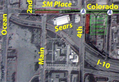 Upper left is a potential terminus station for the Colorado option on Colorado, east of 2nd, in front of Santa Monica Place. It would keep one westbound lane open to serve SM Place. Upper right is the aerial terminus for the Olympic option. To the right of it is a storage track for the Colorado option. Not shown is an alternative potential terminus, left off of Colorado, east of 4th. 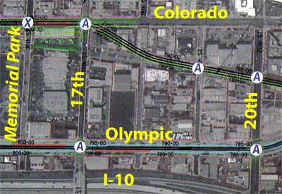 Above shows the transition from right-of-way to Colorado at 17th, with station on Colorado. |
|
|
|
Post by darrell on Mar 26, 2008 22:04:42 GMT -8
Here are two interesting sketches from posters. 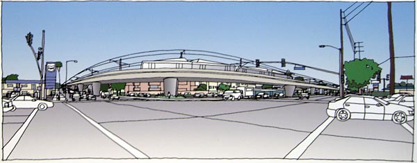 Above is the aerial transition from Venice Blvd. (right) to Sepulveda Blvd. (left). A station is on the far right. It returns to grade on Sepulveda at the top of the hill (left). 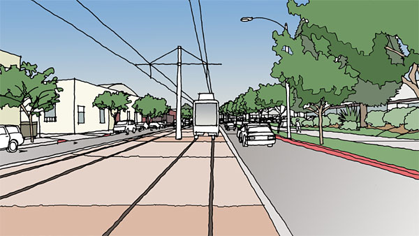 Above is on Colorado east of Lincoln, looking east. |
|
|
|
Post by BRinSM on Mar 27, 2008 8:54:57 GMT -8
I pass the Pico/Sepulveda intersection daily, I can't even imagine what taking Sepulveda down to 1 lane would do to auto traffic in that area. This is going to sound spiteful, but I hope that the CH Nimbys who prefer this route do much of their driving in this area if the Venice/Sepulveda option is chosen. Unfortunately, the stretch of Sepulveda that would contain the tracks is filled mostly rental housing tenants, who don't have near as much political clout as homeowners and business owners. However, maybe there's a way to get UCLA involved since their off campus housing is located along the potential route.
|
|
joequality
Junior Member
Bitte, ein Bit!
Posts: 88
|
Post by joequality on Mar 27, 2008 13:01:31 GMT -8
That meeting was very informative. Richard Thorpe was telling me how the city of Santa Monica wants to transform Colorado into a more transit/ped friendly street. Especially with that one option for the terminus right on Colorado, it should become an even more awesome destination. Traffic is already so bad getting to that area, the Expo will be a huge hit to move tourists, everyday shoppers and workers.
|
|
|
|
Post by Gokhan on Mar 28, 2008 9:25:24 GMT -8
From the Expo phase 2 meeting tonight, here are the station locations and grade crossings / separations proposed so far, from east to west. "Future Action" crossings - like Overland - should be finished in another month or so. Correction: Veteran should be Military. |
|
|
|
Post by Gokhan on Mar 28, 2008 9:45:29 GMT -8
Summary of the preliminary results of the Expo Phase 2 conceptual engineering and draft environmental study
According to the preliminary results, Phase 2 will be built primarily at-grade, just like Phase 1. Below are the details.
Sepulveda already has been decided to be built at-grade (obviously the adjacent Military as well). Overland and Westwood will also be built at-grade unless they determine that the 100 year flood zone between Westwood and Overland doesn't prohibit this. If it does, then the section between Overland and Westwood will be elevated. But given that we had the worst rains of more than a century in the last decade (ten years ago and three years ago), I suspect that this region doesn't get flooded anymore thanks to the storm drains. Therefore, I suspect Overland will be built at-grade as well. In this way they won't have to deal with environmental-justice claims about Farmdale (Dorsey High kids versus Overland Elementary kids).
The proposed grade separations are (in addition to the existing Palms/National/I-10 and Motor/I-10 bridges and I-10 tunnel): Pico/Sawtelle (both streets together), Bundy, and Cloverfield/Olympic (both streets together). But they are still considering Overland and Westwood (flood-zone possibility) and Barrington and Centinela (might not be sufficient land to increase the number of lanes at these crossings in order to decrease the traffic counts).
Note that Bagley will be left at-grade.
On the Venice/Sepulveda diversion option, there are numerous grade separations required, increasing the cost greatly, already being higher because of the extra mile for the diversion. Given the results of the study that the diversion will also have a lower ridership (primarily due to increased trip time and also lack of connection to Westwood/Century City), it is unlikely to be adopted.
Stations: Palms Station may be built immediately west of the Palms/National bridge, possibly with parking under it. My recommendation is to build it slightly further west, behind the storage facility and acquire the storage facility. This would bring the station closer to Motor Ave, as well as being closer to Palms/National, providing a convenient walking distance from both major streets.
Westwood/Century City station is being planned immediately east of Westwood, between Westwood and Overland. They are also planning surface parking in the northern section of the 200-ft-wide right-of-way there.
The other major station that would connect to Westwood as well as the commercial district in the eastern West Los Angeles is being planned just west of Sepulveda, in front of the cement factory, which is already sold to be a transit-oriented development site. There will also be parking at this location. Although, my recommendation is to build the station at Pico/Sawtelle instead, which is very close to the business center immediately to the north. Also, Pico/Sawtelle would provide better station spacing.
West Los Angeles station located at Bundy (adjacent to Olympic) will be elevated with parking.
Bergamot Station, a future transit-oriented development zone, is being planned just east of 26th St.
The optional mid Santa Monica Station is now being planned at 17th St, instead of previously proposed 14th St.
Last but not least, the Santa Monica Station could be built just east of 2nd St on Colorado, which would close the street in one direction. The other alternative is to build it on the Sears Automotive Facility lot east of 4th St in a diagonal manner pointing toward Venice, for a future Green Line connection through Venice/Marina Del Rey/Inglewood.
They are currently very concerned about land acquisition because the cost of land in the Westside and especially Santa Monica is very high. But I believe that they need to acquire more land in order to build this line better.
Possible locations for the maintenance facilities are the Albertson's shopping area in the Culver Junction, the area north of Pico/Sawtelle, or just east of the Bergamot Station (just west of Centinela).
Bike route has been a problem. It looks like they are going to use the 25-ft-wide single-track I-10 tunnel for double tracks, which will probably also slow the trains due to the narrowness of the tunnel. Since the bike path can't go through the tunnel, our suggestion was to route it through the restricted-use easement on the northern edge of the freeway, which has plenty of space and is well-situated for a scenic trail. But apparently they have not been looking into this and to my dismay, there is currently no bike bath between Palms/National and Overland, a distance of more than a mile. Also, they haven't planned a bike path between Sawtelle and north of Pico, another huge gap. I've been telling them to include the bike path on the grade-separation bridge -- only a thin deck, such as on the Rosecrans/Aviation Green Line bridge, is needed, which costs nothing. Hopefully one day they will listen. Otherwise, the bike path will have no real use.
I also asked them about stream daylighting between Overland and Military. It looks like they don't want to touch the storm drains but just pump the water out of them into a decorative creek, if possible.
|
|
|
|
Post by darrell on Apr 1, 2008 21:32:40 GMT -8
Here are better images of the Expo Line phase 2 station maps from tonight's meeting. 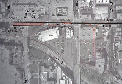 Here's the terminus on Colorado, east of 2nd, with separate pocket track east of 4th on the Sears Auto Center site. Enlarge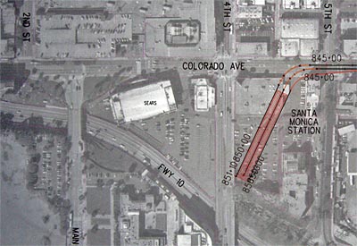 Here's the alternative of the terminus off of Colorado on the Sears Auto Center site. Enlarge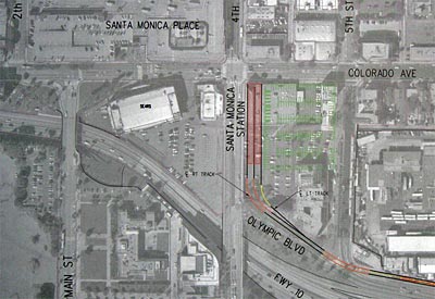 Here's the original Olympic option with elevated terminus on the Sears Auto Center site. Enlarge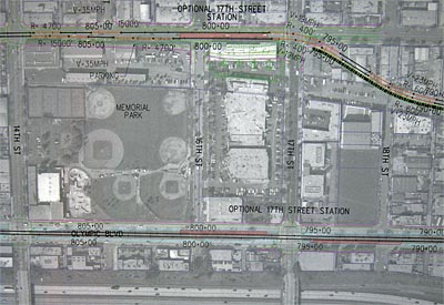 Here are both options' stations at 17th by Memorial Park. Enlarge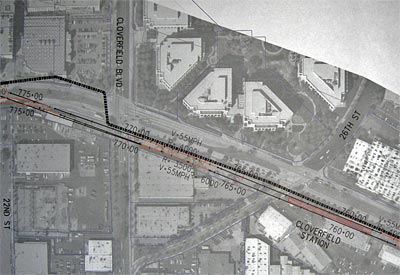 Here's the Bergamot Station site east of 26th. Enlarge |
|
|
|
Post by darrell on Apr 1, 2008 21:40:03 GMT -8
Here are two more sketch images. 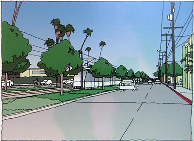 This shows the Olympic option, with existing median and trees replaced with center trackway bordered with landscaped strips between left-turn lanes and far-side station platforms at 17th. Contrast it with the existing median: 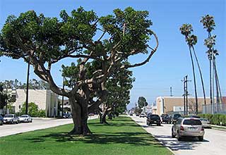 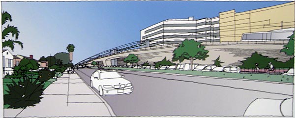 Here's the aerial station crossing Bundy, looking west along Exposition Blvd., station parking along the right-of-way. |
|
|
|
Post by Gokhan on Apr 2, 2008 21:50:50 GMT -8
2nd/Colorado seems to be clearly the best location for the terminus. The tail track included could be used for a future Green Line connection.
I am guessing the 17th St Station will be moved closer to 14th St and off Colorado into the right-of-way. There is no reason to put the station in the median there. Right now they seem to be very concerned with acquisition costs. This could change in the final study once the draft study is approved.
|
|
adamv
Junior Member
Posts: 51
|
Post by adamv on Apr 2, 2008 23:44:30 GMT -8
2nd/Colorado seems to be clearly the best location for the terminus. The tail track included could be used for a future Green Line connection. Why does 2nd & Colorado work better than, say the alternative stopping at about 4th? Once you pass 4th heading west, foot traffic is wild and woolly. There's not much room to maneuver if people are also trying to drive into the SM Place Parking lot. The small park there could be cannibalized for the station, I suppose. What is it about that terminus that makes it a better fit for future Green Line work |
|
|
|
Post by BRinSM on Apr 3, 2008 8:00:41 GMT -8
Actually, foot traffic along Colorado is quite limited, especially when compared to Broadway and the parellel streets north of there. Since the freeway is so close and pedestrian access to cross it is far from friendly (4th St. and Main St. bridges), I doubt that the 2nd/Colorado stop would really have any negative effect on the pedestrian activity of the area. The only area where Colorado sees a jump in pedestrian activity is at Ocean (where the pier begins). Since there are no plans to continue the line that far west, we should be fine.
|
|


 )
) 

