|
|
Post by darrell on May 30, 2008 23:37:31 GMT -8
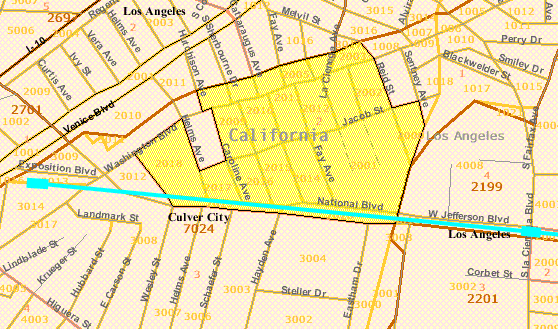
Darrell, You may want to find more up to date numbers than the 2000 Census. My wife is a Demographer with an expertise in Los Angeles and has said that neighborhood had its make up changed radically in the past 8 years. Population data at this detailed geographic level may only be available from the full decennial Census. On the Census website it appears the Annual Population Estimates and American Community Survey only go as fine as a "place" (e.g. a whole city). Does your wife have anything else? how big is the difference in the non-Hispanic white population in that census tract versus the others? It's probably a huge increase even if it's still majority minority. Yes, the overall breakdown I found for the Census Block Groups closest to the Expo Line between Ballona Creek and Vermont is 50% Hispanic or Latino, 42% Black or African-American alone, 4% Asian alone, 2% White alone, and 2% other. These block groups ranged from 1-4% White. One Block Group near Crenshaw is 34% Asian; two others are over 20%. Culver City Tract 7024 Block Group 2 is 45% Hispanic, 6% Black, 11% Asian, 33% White, and 4% other. North-of-USC Tract 2247 Block Groups 1 and 2 average 15% Hispanic, 6% Black, 54% White, 20% Asian, and 5% other. |
|
|
|
Post by Gokhan on May 31, 2008 2:16:34 GMT -8
What's almost being forgotten in this discussion is that Culver City got only one grade-separation structure -- Venice/Robertson -- which is the worst crossing in Phase 1. With the elevated station placed south of Venice, there is no way the structure could come to at-grade at Washington/National (700 ft is needed past the station platform) -- that's why it also extends over these streets.
As a side note, the no-cost street alignment just west of Ballona Creek was necessary as a result of the new railroad bridge over the creek. Besides, why and who in the world would have the street zig-zag the rail tracks at the foot of the bridge?
So, the race discussion is not only outrageous but also completely irrelevant.
Anybody who wants to argue otherwise?
|
|
|
|
Post by damiengoodmon on May 31, 2008 9:15:26 GMT -8
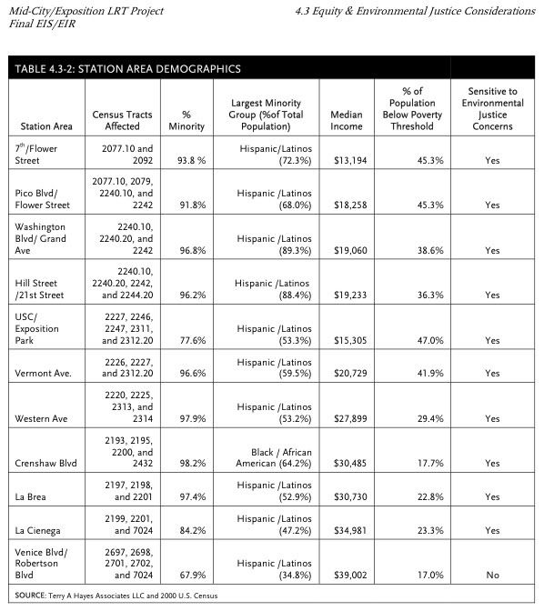
Darrell, You may want to find more up to date numbers than the 2000 Census. My wife is a Demographer with an expertise in Los Angeles and has said that neighborhood had its make up changed radically in the past 8 years. LOL! How...predictable this all is. You see last night I sent the link to this conversation to one of the first people to whom I showed the census tract data and he said, "You called it." What did I call? I stated the second I finished the map on google that some level data would be produced by Darrell Clarke to show that there were no white people getting special treatment. This is after all the same Darrell Clarke that said to the Expo Authority board that Ballona Creek is in South LA, and has argued in this very thread that at-grade rail is just as safe as grade separated rail, and sound walls aren't necessary for classrooms 30 feet away from a crossing with trains coming by at 55 mph every two minutes blowing it's horn 1000 times a day. NONE of which, if my memory serves me correctly, has been questioned by anyone but me on this message board by the way.And after all, MTA masked the environmental justice issue in their EIR by blending the majority white census tract (7024) with adjacent census tracts that were majority-minority including some that didn't even touch the tract: Speaking of not touching the track the reason 2224 is not on the map is because it does not touch the tracks. It starts West of Figueroa, a city block east of Flower. Nonetheless, you see I've been working with these screens and census level data: link. It's the census level data that shows, among other information both the racial and economic breakdown. I suggest people re-read the environmental justice laws we've referenced to date to understand the importance of the last two words stated in that previous sentence with respect to 2224 and 2227.  As anyone who saw the presentation at the 5/22 and 5/29 meeting or has been closely reading our emails over the past 6 weeks, me and the 2007 California Lawyer of the Year are ten steps ahead of ya Darrell. (And speaking of community meetings, why doesn't this crowd come to them and tell the parents and residents who are actually being impacted why the Dorsey holding pen and at-grade rail is safe and the current design doesn't impact traffic or adversely impact the community? I'm continually amused by folk who are way too comfortable making bold statements, accusations, and insults online - many anonymously - but never actually show up at the meetings IN THE COMMUNITIES THAT ARE IMPACTED to make the same statements. I tell my point of view, publicly and vocally at the MTA Board, in the Miracle Mile, at USC, in Culver City and in Santa Monica. Darrell has introduced a new level data - block data from a different screen on the census website. For those who don't know, census data is basically broken down like this: County > Census Tract > Block Group > Block. Darrell, through his argument implies that the census tract level data isn't a good indicator and supplies the block group. This begs two questions, one academic and the other about the methodology decided by the author: a) how does the census tract show a majority white area while the block group level doesn't and what does that mean? b) if the author is really interested in seeing which communities that are directly adjacent to the tract are affected, why isn't the block data referenced instead of or in addition to the block group data? By the way the blocks are those numbers on the image Darrell produced (2001, 2015, 3004, 3014, etc): Let's take "b" first. If Darrell is really interested in seeing the communities effected why did he choose block group and not block level? So you know, he had a choice - to pick block group or block on the drop down menu, and he deliberately choose block group instead of block level. My guess is he saw that the block level data did not fit the argument he's making, but the block group level data does. Because if you look at the block data AND assess the changes in the area that have been referenced by Matt that EVERYONE knows about and it's clear this is a majority white area and Darrell's argument holds no water. But that won't stop Darrell & Co. Now regarding "a," back when the environmental justice complaint was sent to the FTA (BEFORE THE RECORD OF DECISION WAS ISSUED BY THE WAY), those that were working on this issue were specifically asked by the feds to send not the block level, not the block group level data, but the census tract level data. I followed-up in 2007 and asked why they asked for census tract data instead of block group or block data, and their response was two-prong: 1) Adverse effects are both down to the street level, but also community-based and census level is the best when assessing, in the case of light rail, the large impacts of traffic and related air pollution from idling engines from street closures, diverted traffic and crossing gates. 2) Though block group and block level data can be useful in less densely populated areas where the census tracts are geographically large and impacted minority populations can be hidden (in which case field investigations are required), in large urban areas where the block group and block are geographically so small and the populations transient they can serve to do the exact reverse and mask benefits being felt by a majority white area. (THIS IS EXACTLY WHAT DARRELL HAS DONE!) Also, stated was the fact that the Census is a calculation/extrapolation/assumption that mathematically compensates for those who do not fill out the forms. Therefore, the "margin of error" with a larger sample (census tract) is much lower than at block or block group level. This again is why field investigations are necessary. And as has already been stated by Matt, and stated in my reply, any person that actually lives or visits the area knows it's become increasingly more white, and was majority white in '05 when the original environmental justice complaint was sent to the FTA BEFORE the Record of Decision was issued.Darrell knows that, but he's looking for something - anything really. So he'll tout this as a major find and his sidekick Gohkan will claim that this completely exposes me as a BRU-spy/subway-lunatic on the payroll of Exxon-Mobil. Just another day in the world of "transit advocacy." Have a good weekend. |
|
|
|
Post by mattapoisett on May 31, 2008 9:39:46 GMT -8
Does your wife have anything else? Yes. Outside of the Decennial Census, there are many companies that collect data (Census, ACS, Yearly Pop Estimates and other sources) and model population, demographics etc. at a very minute level. This data is used by people like my wife for specific businesses and/or city planning purposes and for very good reasons (depite her own feelings about public transportation, which is why I still love her) she refused to let me quote real numbers directly here. But also note that the data can be admissible in a court of law. The reason I questioned your numbers in the first place is not because I happen to have a data fairy on hand, but I know the neighborhood. 2 years ago we were looking to live there and lost out on several apartments because we were not quick enough and we have several friends who now live within the boundaries of your map. Next time you're at Surfas, Fathers Office, Beacon Etc. go across the street in to that neighborhood I believe you will find the change and the various shades of blue, pink and orange hair dye is noticeable. Take Care - P. |
|
|
|
Post by darrell on May 31, 2008 11:20:28 GMT -8
LOL! How...predictable this all is. As in no substantive rebuttal from you? Speaking of not touching the track the reason 2224 is not on the map is because it does not touch the tracks. It starts West of Figueroa, a city block east of Flower. Same as Tract 2340, south of Rodeo, west of Van Ness, yet you included that one. Not to mention that residents of Tract 2247 ( there is no Tract 2224) are closer to the tracks and more affected by them than residents of Tract 2246 across the 110 Freeway. why did he choose block group and not block level? So you know, he had a choice - to pick block group or block on the drop down menu, and he deliberately choose block group instead of block level. My guess is he saw that the block level data did not fit the argument he's making, but the block group level data does. Wrong again. The total of Blocks 2014-2018 that touch the right-of-way is 53% Hispanic, 27% White (vs. 33% for the whole Block Group), 10% Asian, 6% Black, and 4% other. 2) Though block group and block level data can be useful in less densely populated areas where the census tracts are geographically large ... Yes, Tract 7024 is the largest along Expo Line phase 1. You've now created a conflict, Damien: do you argue the impacts of light rail are on only its immediate neighbors, or on people living in the far reaches of a larger Census Tract? and was majority white in '05 when the original environmental justice complaint was sent to the FTA BEFORE the Record of Decision was issued The lack of actual evidence is telling. |
|
|
|
Post by Gokhan on May 31, 2008 11:57:30 GMT -8
So, Damien, you failed to contest my points about grade separation in Culver City and chose to hide behind your race delusion again. As predictable you make your repeated move of not debating any real technical aspects but making a political spin-off out of this.The users of the old Transit Coalition discussion board will remember that there used to be a character named "Diane Shapiro" on that board. She would always explain with her documentation and extensive arguments that how the Expo Line would ruin Cheviot Hills, by creating electromagnetic fields, increasing traffic on Motor Ave, decreasing the housing values, preventing kids from learning at Overland School, and so on. Damien, I don't think you are a BRU or Exxon spy. I think you are the new Diane Shapiro of this discussion board -- that is the Queen, uh, sorry, the King of all the Expo NIMBYs. Give us the transit advocates some break sometime, will you? |
|
|
|
Post by erict on May 31, 2008 16:20:05 GMT -8
Maybe he IS Diane Shapiro . I always thought Expo would be a fight for every square inch of construction, and it is turning out the be true (much like the Red and Gold line construction insanity). First it was Cheviot Hills, Now Damien...Expo must prevail in the age of $4+ gas or LA is doomed to having no more rail construction and we all will suffer for it. |
|
|
|
Post by Transit Coalition on May 31, 2008 16:34:05 GMT -8
Maybe he IS Diane Shapiro . I always thought Expo would be a fight for every square inch of construction, and it is turning out the be true (much like the Red and Gold line construction insanity). First it was Cheviot Hills, Now Damien...Expo must prevail in the age of $4+ gas or LA is doomed to having no more rail construction and we all will suffer for it. Nope! Diane registered for this discussion board back in November 2007. She has not posted and she hasn't even logged in since about a week after she registered. She is probably focusing her attention on some other important issue! |
|
|
|
Post by darrell on Jun 1, 2008 6:02:51 GMT -8
This is after all the same Darrell Clarke that said to the Expo Authority board that Ballona Creek is in South LA, This is after all the same Damien Goodmon who argues: were specifically asked by the feds to send not the block level, not the block group level data, but the census tract level data. And whose very own Census Tract map clearly shows Tracts 2199 (98% non-White) and 2201 (99% non-White) end at the Los Angeles city limit of Ballona Creek: 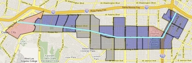 The facts are clear and conclusive The facts are clear and conclusive. But they obviously haven't swayed Damien from his lonely quest for light rail in an extended trench, as built no place else in the United States in the modern light rail era. Unlike on this discussion board, the plaintiff will have to respond to these inconvenient facts under court cross-examination. |
|
|
|
Post by metrocenter on Jun 2, 2008 9:39:24 GMT -8
Nope! Diane registered for this discussion board back in November 2007. She has not posted and she hasn't even logged in since about a week after she registered. She's probably sitting back, laughing and watching as Damien does her work for her. |
|
|
|
Post by Gokhan on Jun 3, 2008 10:26:47 GMT -8
While Damien fights for a trench, they are now starting to build the La Brea bridge. When will the NIMBYs stop fighting? Will they stop when Phase 1 is completed? Will they keep fighting until Phase 2 is completed? Will their lawyers desert them anytime soon? Will they try to sabotage the line? |
|
|
|
Post by Gokhan on Jun 4, 2008 12:32:00 GMT -8
USC is finally appreciating the Expo Line and urging for a pedestrian-oriented campus for the future, centered around the "light-rail" stations, also with plans to narrow Jefferson Blvd to integrate the surrounding neighborhood into a pedestrian-friendly area. Some common sense at last. Remember the previous opposition by the USC administration, calling for an underground Expo Line that preserves the eight-lane-wide Exposition Blvd? Sounds familiar?  |
|
|
|
Post by kenalpern on Jun 4, 2008 12:42:52 GMT -8
History will either speak poorly of, or forget entirely, the knuckleheads that opposed the stations that will make a potentially HUGE difference to the USC/Exposition Park/Museum region.
|
|
|
|
Post by Gokhan on Jun 4, 2008 12:55:33 GMT -8
History will either speak poorly of, or forget entirely, the knuckleheads that opposed the stations that will make a potentially HUGE difference to the USC/Exposition Park/Museum region. What about those who are opposing light-rail and calling for a below-ground line now, just like USC did until last year or so? |
|
|
|
Post by Gokhan on Jun 4, 2008 14:20:12 GMT -8
I noticed the wonderful pun later.  This latest LA Times interview with Damien is titled "A fight over the Expo Line." In this interview he expresses his worries about the well-being of gang members fighting over the Expo Line (tracks). |
|
|
|
Post by Gokhan on Jun 5, 2008 7:12:59 GMT -8
There is always a second side to a story. In this case the second side makes much more sense. You can easily sense the honesty and dignity of the Expo CEO Rick Thorpe, as opposed to the delusional and hysterical NIMBY view of Damien and Co. Here is Chapter 2. |
|
|
|
Post by metrocenter on Jun 5, 2008 9:03:15 GMT -8
The vast majority of transit users in L.A. are taking transit because they have to. We're trying to get to work or school. We have no choice. We want our transit system to be safe, fast, clean and reliable. For us, the issue of transit is not about abstract fantasy maps or making a political name for ourselves. It's about basic survival in the city.
The claims of environmental racism are an attack on the already-anemic progress of our rail system. And thus, they are an attack on the entire transit-riding community. We are being told to take a back seat to a few homeowners trying to kill this project. It's not fair.
If I had all the free time Damien seems to have, I would not hesitate to start my own pro-Expo advocacy coalition. But I don't, because I have to be at work 9 hours a day, plus another 3 hours of commute time due to the deficiencies of our current transit network.
We do not have the luxury of waiting for a gold-plated Expo Line. We need this rail line to be built as it is, right now.
|
|
|
|
Post by Gokhan on Jun 5, 2008 12:55:48 GMT -8
Wow, have you guys seen how they are unanimously trashing Damien on the LA Times blogs?LA Times blog June 4LA Times blog June 3Damien, does this give you any clue about you being right or wrong on this issue?
|
|
|
|
Post by Gokhan on Jun 5, 2008 13:52:01 GMT -8
This video is truly shocking: a car driving on the wrong side of the road hits a man and no one comes to his help. From CNN in today's news. So much said on the Expo Line safety. The real world seems to be not only full of much more serious dangers but there seems to be a shocking insensitivity in our communities, when it comes to real-life situations, as opposed to the attention to the distorted visions of NIMBYs, who oppose community improvements. |
|
|
|
Post by Gokhan on Jun 5, 2008 14:42:27 GMT -8
See the the presentation by the Expo Authority staff at today's board meeting. Pictures tell a great story of how the USC trench is being built. Note the steel reinforcement bars sticking out of the ground from the cast-in-drilled-hole (CIDH) piles. You can see in the same picture that a narrow concrete crown is cast on these rebars. Then the large concrete girders are laid across these crowns but not attached to them, so that they could freely move and slide during natural vibrations and earthquakes, without fatigue- or stress-fracturing. Once the girders are placed, a thin concrete deck is cast over them. Finally the asphalt pavement is poured onto the concrete deck. They will later excavate the earth beneath the girders and between the walls formed by the adjacently placed CIDH piles. |
|
|
|
Post by metrocenter on Jun 5, 2008 14:45:08 GMT -8
Can you imagine if someone used this incident to call for grade-separating pedestrians from road traffic? That would be insane. Yet, people claim that a train crossing - involving gates, bells, flashing lights, and a professional train driver - is so unsafe that it must be put underground. Life is inherently unsafe. It always has been, and always will be. People need to begin taking more responsibility for their own safety, rather than expecting the entire world to be baby-proofed for them. Yes, the hit-and-run driver committed a crime and should be brought to justice. But don't forget the old man was jaywalking as well. A case can probably be made that he was harder to see due to walking in the street outside of a crosswalk. Should we permanently fence off the street to prevent this from ever happening again? |
|
|
|
Post by darrell on Jun 6, 2008 22:05:38 GMT -8
Emailed response this morning to Mark Jolles and others. (I'll add his original text if he gives permission.)
---------------
Let's look at light rail projects in large cities that received federal New Starts funding in the last few years.
The model of at-grade light rail in the median of a boulevard that the Expo Line will use from Trousdale to Gramercy (and similarly the side of Flower Street and crossing Crenshaw), follows the standard used on the federally-funded Portland Interstate MAX line, most of Phoenix's new line, half of Seattle's new line, and the Los Angeles Eastside Gold Line outside the Boyle Heights tunnel and 101 freeway bridge.
The model of at-grade light rail on private right-of-way with gated crossings (and bridges where needed for cross traffic) that the Expo Line will use in phase 1 west of Gramercy follows the other standard, used recently on federally-funded lines in Charlotte, Dallas-Plano, Minneapolis-Hiawatha, Portland-Hillsboro, and Salt Lake City-Sandy.
Do you call all of these a "small town or small city"?
Conversely. the Minneapolis-St. Paul Central Corridor line cannot meet funding standards with the tunnel through campus the University of Minnesota sought, and the U of M may finally accept at-grade to meet FTA cost-effectiveness standards. In fact, there is no New Starts-funded new light rail line in an extended trench.
The Expo Line's capacity will be complemented by later extension of the Wilshire subway west, in a corridor that does have the development density and lack of existing right-of-way to justify heavy rail subway construction.
The "at grade light rail lines that got stuck in traffic since at least the 1950s" were streetcars with tracks in traffic lanes. Venice Boulevard east of Arlington is a classic example. But there are no Expo Line tracks in traffic lanes.
|
|
|
|
Post by darrell on Jun 6, 2008 22:09:33 GMT -8
Emailed response tonight to Damien Goodmon and others. (Damien as a member of this board may post his original texts.)
---------------
Let's address the points you've raised in these two emails.
1. LRT RIDERSHIP THRESHOLD
We had a conversation about light rail ridership on TTC's discussion board. I'll update it here with 1Q 2008 APTA ridership statistics for all recent light rail systems with over 50,000 average weekday boardings (000s):
Los Angeles - 130.9
Portland - 103.8
San Diego - 98.7
San Francisco - 83.0
St. Louis - 67.3
Denver - 65.4
Dallas - 62.0
Sacramento - 52.4
You objected before that these were systems, not single lines. But Portland's Blue Line (Hillsboro-Gresham) exceeded 60K even before the Airport and Interstate lines opened. San Diego's original Blue Line, always the heaviest and now with twice the peak train frequency of the Orange or Green Lines, must exceed 50K of their system total.
Of federally-funded projects nearing completion, Phoenix projects 49,900 daily riders in 2020, and Seattle (Central Link + University Link extension) projects 82,700 in 2030 (from FY 2008 New Starts Report).
The section you cite in Metro's Transit Service Policy appears quite clear: "Planning warrants are minimum demand thresholds that are used to identify the most effective transit solution for a particular corridor." That is, 50,000 total daily boardings is a "guideline" MINIMUM threshold for heavy rail, not an absolute MAXIMUM for light rail.
The decision for the Expo Line as mostly at-grade light rail was made by Metro in 2001 and 2005, and approved by the FTA in 2006, consistent with FTA and Metro standards. The Wilshire corridor is the Westside's heavy rail line.
2. SPEED
The difference in speed on the Expo Line between the line as approved and full grade separation from Trousdale to La Brea is only around 1-3 minutes (9-11 minutes vs. 8 minutes for 4 miles).
How much greater ridership would you get for 1-3 minutes saved? Think that would cost-justify to the FTA $400 million+ additional cost, plus a few years delay?
3. SAFETY
You wrote, "if you have a conservative estimate of 3 deaths a year". Why not use the ACTUAL experience of the Pasadena Gold Line, ZERO deaths a year? Which matches the Expo Line right-of-way west of Gramercy.
Yes, the Pasadena Gold Line contains grade crossings on significant boulevards at Figueroa Street north of Avenue 60 in Highland Park, Pasadena Avenue-Monterey Road and Mission Street in South Pasadena, and California and Del Mar Boulevards in Pasadena.
Re, "the Washington Blvd section of the Blue Line, which Darrell Clarke himself has admitted is like the Expo Line design from Trousdale to Western":
You know that the Eastside Gold Line, Portland Interstate MAX, and Phoenix line are all current federally-funded comparables to the Expo Line from Trousdale to Gramercy.
4. EMERGENCY RESPONSE
Emergency response of fire and police across a light rail line is obviously important. Which must have been successfully handled across numerous light rail grade crossings in different cities.
"Fire Station 34 is about 200 feet from the 7th Ave/Exposition crossing where during peak hours crossing gates will be down roughly 40% of the time." The relevant figure is a 30-40 second worst-case delay (fire truck arrives just as gates go down), compared to the usual delay of slowing to safely cross an existing intersection.
(BTW, 24 trains/hour peak in both directions x 30 seconds = 20%, not 40%. While a typical signal direction is red 50%+.)
"Fire Station 94 uses the Farmdale Avenue crossing as it's major access route to the north." Sounds like a reason to favor the at-grade crossing that wouldn't close Farmdale.
|
|
|
|
Post by roadtrainer on Jun 7, 2008 9:04:26 GMT -8
I can't help but think that when Damien Goodman gets on his Little soap box and preaches "The trench! The trench!" I am reminded of Fantasy Island! and his arguments that we going to get the trench is just like the Jerry Springer Show! All stupidity and all bullish_t!! Sincerely The Roadtrainer  |
|
|
|
Post by darrell on Jun 8, 2008 11:57:46 GMT -8
Here's another look at Census data, also in response to Damien's comments on the LA Times Bottleneck Blog. Let's look at the neighboring population within a consistent 1/4 mile radius of the Expo Line in Culver City and around USC (counting 2000 Census Blocks where the majority of the Block is within 1/4 mile of the line). The dark blue lines in the maps below mark 1/4 mile. 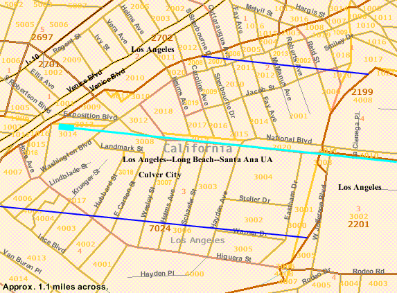 The population of Census Blocks within 1/4 mile of the Expo Line within Culver City Tract 7024 was 61% non-White. Its 2,147 people were 39% Hispanic (843), 39% White (845), 11% Asian (245), and 5% Black (106). 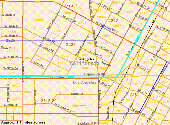 The population of Census Blocks within 1/4 mile of the Expo Line in Los Angeles between Vermont Avenue and Jefferson Boulevard, Census Tracts 2227, 2311, and 2312.20, was 76% non-White. Its 756 people were 48% Hispanic (365), 24% White (179), 14% Black (103), and 10% Asian (79). 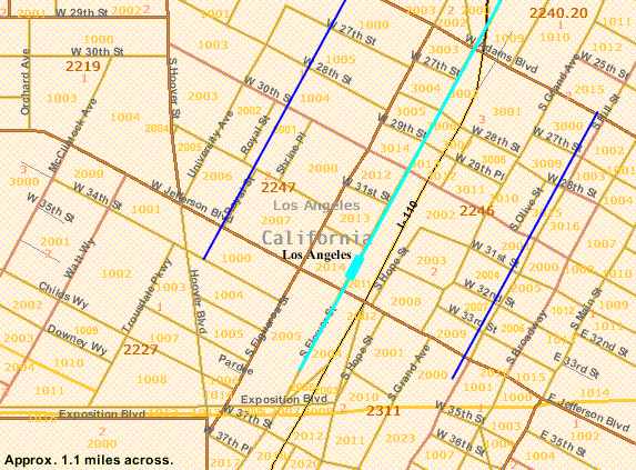 The population of Census Blocks within 1/4 mile of the Expo Line in Los Angeles between Jefferson and Adams Boulevards, Census Tracts 2246 and 2247, was 55% non-White. Its 3,009 people were 45% White (1,369), 28% Hispanic (843), 17% Asian (507), and 7% Black (197). 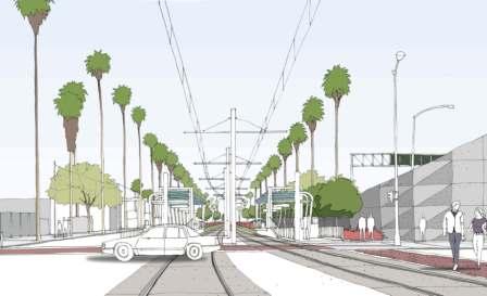 1. So there are NO majority-white neighborhoods along phase 1 of the Expo Line. 2. And the neighborhood with the largest White population, Jefferson-Adams, will have at-grade tracks (above). 1. So there are NO majority-white neighborhoods along phase 1 of the Expo Line. 2. And the neighborhood with the largest White population, Jefferson-Adams, will have at-grade tracks (above). |
|
|
|
Post by Gokhan on Jun 8, 2008 12:12:32 GMT -8
Last Phase 2 meeting tomorrowTomorrow's Phase 2 meeting, which will announce all the Phase 2 grade crossings, should be a full house, including all the supporters and all the NIMBYs. In the past there have been disturbances; so, hopefully there will be cops. This meeting is a Phase 2 milestone because it's the final opportunity for the public for two-way interactions with the Expo Authority, before it nears the construction stage, a year and a half from now. Meeting details: Monday, 06/09/2008, 6:30 - 8:30 PM (in open-house settings) Vista del Mar Child and Family Services Gymnasium Building (at the east end of the campus) 3200 Motor Avenue Los Angeles CA 90034 (at the Palms - Cheviot Hills border) (Parking is available on the campus)
|
|
|
|
Post by darrell on Jun 8, 2008 23:06:23 GMT -8
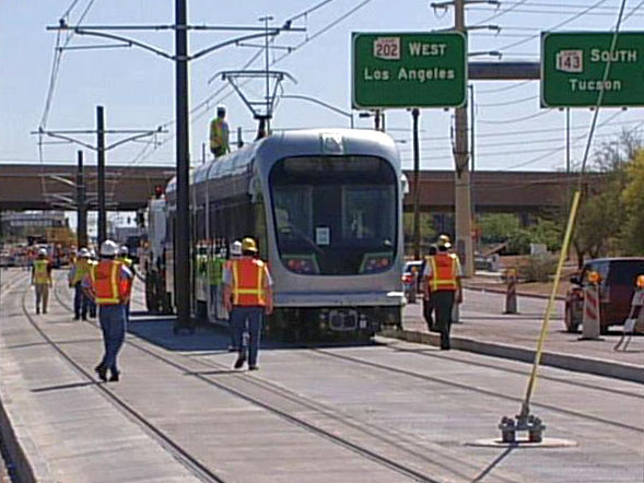 This photo and article from Phoenix's abc15.com reports beginning testing of an LRV on the new tracks in Tempe and Mesa. Phoenix projects 49,900 daily riders in 2020, about the same as the 51,400 in 2020 projected for Expo LRT in its 2001 Draft EIS/EIR. Most of the route is at-grade in boulevard medians. Here's a typical station, photo from Valley Metro. 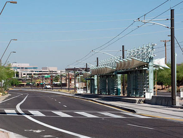 |
|
Adrian Auer-Hudson
Junior Member
 Supporter of "Expo Light Rail - Enabler for the Digital Coast".
Posts: 65 
|
Post by Adrian Auer-Hudson on Jun 9, 2008 9:29:01 GMT -8
Last Phase 2 meeting tomorrowTomorrow's Phase 2 meeting, which will announce all the Phase 2 grade crossings, should be a full house, including all the supporters and all the NIMBYs. In the past there have been disturbances; so, hopefully there will be cops. This meeting is a Phase 2 milestone because it's the final opportunity for the public for two-way interactions with the Expo Authority, before it nears the construction stage, a year and a half from now. Meeting details: Monday, 06/09/2008, 6:30 - 8:30 PM (in open-house settings) Vista del Mar Child and Family Services Gymnasium Building (at the east end of the campus) 3200 Motor Avenue Los Angeles CA 90034 (at the Palms - Cheviot Hills border) (Parking is available on the campus) May I encourage all who can, to attend this meeting. Moreover, I advise you to be calm, firm and non-violent. Be prepared to offer constructive input. Stand your ground. "Let us therefore brace ourselves to our duties, and so bear ourselves that if Expo and its supporters last a thousand years, men will still say, 'This was their finest hour'" Winston Spencer Churchill misquoted by Adrian Auer-Hudson, :-) Adrian |
|
|
|
Post by metrocenter on Jun 10, 2008 7:24:49 GMT -8
At last night's meeting, the MTA announced their conclusion that the crossings at Overland, Westwood, and Sepulveda would all be at-grade. This surprised and angered many people in the audience, which consisted of a few hundred people, mostly from the surrounding neighborhood.
Some argued that the grade crossing would cause increased traffic congestion. Others argued that the mitigations (in the form of additional lanes) would increase traffic.
LADOT is still working with the MTA, but has not signaled that they agree with the results of the analysis.
|
|
|
|
Post by metrocenter on Jun 10, 2008 7:35:52 GMT -8
Last night, we saw Damien Goodman at his worst. While he clearly came well-prepared and is very well-spoken, this was overshadowed by his complete disrespect for the process, for the dissenting minority opinion, and for the attendees of the meeting. He held discussions in the back of the room that were disruptive, and he asked questions out of turn. And worst of all, he talked over me and others who had the microphone.
Damien, your playground-level tactic of bulling speakers is cowardly, and it only hurt your cause last night.
Is there something unclear about the two-minute rule? Were you not allotted the same two minutes as me and everybody else?
Or does your objective (killing at-grade rail in L.A.) justify your gestapo tactics of shouting people down during their two minutes of speaking time?
|
|


 This latest LA Times interview with Damien is titled