|
|
Post by Justin Walker on Oct 28, 2009 17:22:37 GMT -8
This may be pie in the sky, but are you suggesting it would therefore be better to have the light rail extension by the SR-60 choice and instead of a Washington Blvd. branch of the Gold LRT have an eastbound extension of the HRT Red Line to Whittier via Whittier Blvd? This is another one of those instances where looking backward can help to look forward. Building two rail lines in the Eastside is definitely not a new idea. In fact, almost exactly as Ken suggests, the 1991 LACTC Rail Plan called for both: 1) Segment 3 Red Line (HRT) to East LA along Whittier Blvd. 2) LRT along the "Route 60 Corridor in the San Gabriel Valley" 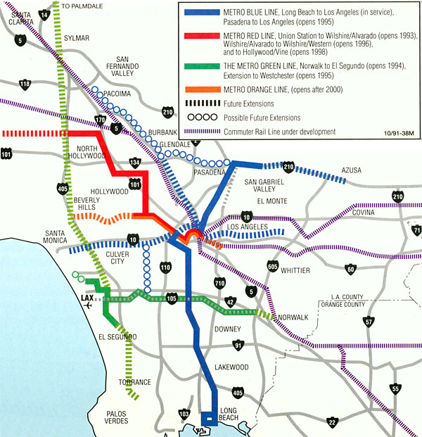 (This map only shows the HRT Red Line out to Whittier/Atlantic, but it could certainly be extended further east along the Whittier corridor.) |
|
|
|
Post by Philip on Oct 28, 2009 20:25:07 GMT -8
I was looking to see what some other destinations might be possible for a North/South line. Below Ontario Airport, there is the Vineyard Shopping Center, literally right under the Pomona freeway. I don't know if a ROW exists or not, but if the Eastside line could be extended this far East, the Shopping Center could become the terminus of the Eastside line and the Southern terminus of the North/South line.
The cities served would be Avocado Heights, South La Puente, South San Jose Hills, Walnut, South Pomona, and South Ontario.
Of course, for that to work, the Eastline line would have to continue another 26 miles down the 60 freeway to connect.
Would this ever be feasible, or would Metrolink better serve this area?
|
|
|
|
Post by warrenbowman on Oct 28, 2009 21:46:21 GMT -8
Philip that route would work great for me, but I think Metrolink already runs along the 60.
|
|
|
|
Post by bobdavis on Oct 28, 2009 22:37:43 GMT -8
Light rail in the median of Rosemead Blvd? That would suit me fine--I live about four blocks away from Rosemead and Duarte (between Arcadia and San Gabriel) and it would mean a good connection to the Gold Line instead of the bus line with 40-minute headways. Of course, even if such a rail line is built, I will be long gone to the great railfan meeting in the sky before the first wheel turns on it.
|
|
|
|
Post by kenalpern on Oct 29, 2009 6:28:48 GMT -8
Interesting ideas, folks. Bob, that is an amazing fact--the combined LRT/HRT idea is actually not new at all...and I suspect would already be well under way if the Eastside didn't have a screaming, tempertantrum-fixed whiner to be its supervisor.
Well, if Jeremy and/or any of you can come up with a map that we can throw out to the media, I'm pretty sure we'll see the combined LRT/HRT effort bear fruit--with the connecting Rosemead or any other north-south line--because an Eastside rail network makes as much sense as the Eastside rail network.
|
|
|
|
Post by metrocenter on Oct 29, 2009 7:13:36 GMT -8
When that map came out (1991), only the Blue Line was running. I remember staring at that map back in the day and trying to imagine what a subway in L.A. would be like.
|
|
|
|
Post by jejozwik on Oct 29, 2009 9:43:17 GMT -8
Well, if Jeremy and/or any of you can come up with a map that we can throw out to the media, I'm pretty sure we'll see the combined LRT/HRT effort bear fruit--with the connecting Rosemead or any other north-south line--because an Eastside rail network makes as much sense as the Eastside rail network. what more would you like to see in it? besides the DTC and expo. [both are in the local copy, not uploaded yet] |
|
|
|
Post by Dan Wentzel on Oct 29, 2009 11:33:36 GMT -8
Make me happy and throw in the Pink Line through West Hollywood.  Also, the Harbor-subdivision route. |
|
|
|
Post by kenalpern on Oct 29, 2009 21:03:39 GMT -8
All those Westside (or, perhaps, I should say west of the 110 and the 101 freeways) rails are great, and the maps already exist.
I'm talking about the Eastside rail lines that will, in another generation and with another, better Eastside supervisor or two, be as vital for the region's growth as any Westside endeavour.
|
|
|
|
Post by Dan Wentzel on Oct 30, 2009 9:20:19 GMT -8
Well, double tracking Metrolink would be great, but since it doesn't add a new line on a map it probably won't impress anyone.
|
|
|
|
Post by kenalpern on Oct 30, 2009 11:08:27 GMT -8
It will to those who live east of Downtown and who have access to it. For those of us in the Westside, South Bay and Long Beach area, the whole concept of Metrolink is so foreign to us, and meaningless to us, that those in the SGV, SFV and other regions served by Metrolink would probably not understand.
|
|
|
|
Post by masonite on Oct 30, 2009 18:24:50 GMT -8
This may be pie in the sky, but are you suggesting it would therefore be better to have the light rail extension by the SR-60 choice and instead of a Washington Blvd. branch of the Gold LRT have an eastbound extension of the HRT Red Line to Whittier via Whittier Blvd? This is another one of those instances where looking backward can help to look forward. Building two rail lines in the Eastside is definitely not a new idea. In fact, almost exactly as Ken suggests, the 1991 LACTC Rail Plan called for both: 1) Segment 3 Red Line (HRT) to East LA along Whittier Blvd. 2) LRT along the "Route 60 Corridor in the San Gabriel Valley" (This map only shows the HRT Red Line out to Whittier/Atlantic, but it could certainly be extended further east along the Whittier corridor.) That map actually shows a relatively efficient string of lines that is achievable. Too bad we didn't just go with this, with a few modifications. Notice the long continuous Valley to Torrance line with strong connections to Expo, Purple and Green Lines. That would be a very successful line among Valley, Westside, and South Bay users as well as those from other areas like South and Central LA with one transfer. Also, notice the Vermont line (although they don't seem to connect the portion from Expo to Wilshire for whatever reason) and of course no Crenshaw Line. Much more efficient. |
|
|
|
Post by jejozwik on Oct 30, 2009 19:53:55 GMT -8
 newish. |
|
|
|
Post by kenalpern on Oct 31, 2009 12:28:27 GMT -8
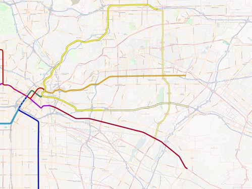
That map is DELIGHTFUL, Jeremy. I'd like to use that in an upcoming CityWatch article. Is it OK if I give you credit, or do you prefer to remain anonymous (one of the greatest mapmakers I've ever known, and whose maps I used more than any other to help push for getting the Green Line to LAX, insisted on being anonymous). Your call, Jeremy.
Jeremy, this is a map that needs a lot of highlighting...and I intend to do it.
|
|
|
|
Post by kenalpern on Nov 2, 2009 6:55:31 GMT -8
Thanks to all who've helped so far in this effort. For those who read CityWatch, I've included a lot of these maps in an article scheduled for tomorrow's CityWatch.
|
|
|
|
Post by jejozwik on Nov 2, 2009 10:27:49 GMT -8
|
|
|
|
Post by Justin Walker on Nov 2, 2009 12:16:04 GMT -8
newish. Cool map! I personally liked the Whittier subway as you showed it in the first map (for technical reasons, not for any defect of the second map). I know many people on these forums like the idea of a Purple Line extension to Whittier Blvd directly from the 7th St./Metro Center station. Yet, I favor simply extending the Red/Purple Line from Union Station because of: 1) Consistency with Metro's 80's and 90's Red Line expansion plans. 2) Retained operational simplicity 3) Union Station remains connected to an important corridor. 4) A junction at 7th St./Metro Center would be essentially impossible to construct. While such a project is still entirely conceptual and technical details are decades away from needing to be ironed out, I would like to point out some of the features of the existing Red/Purple Line subway between Pershing Square and 7th St./Metro Center: The horizontal and vertical alignments of this segment represent the extremes of our subway system: 1) The alignment features tight 1000'-radius curves (making it nearly the tightest curve in the system, although Wilshire-Vermont has 900' curves): 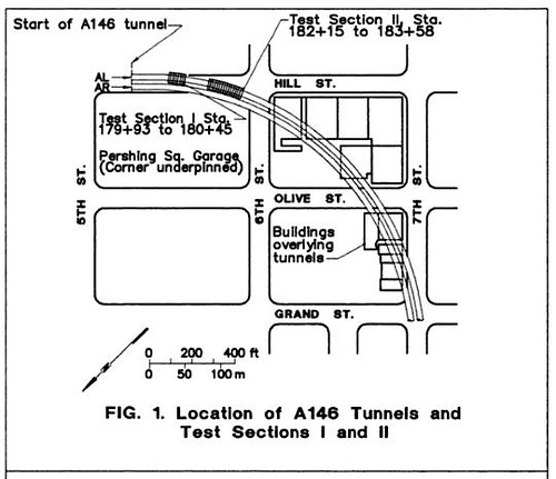 2) To avoid the Pershing Square underground parking garage and two deep building foundations, the segment features the steepest grades of the LA subway (4%): 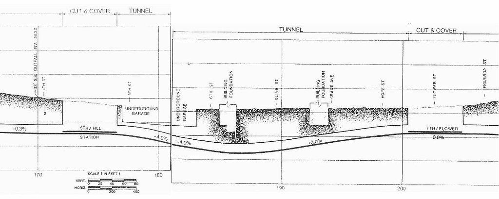 Needless to say, fitting in a junction in all that would be extremely difficult, if not completely impossible. |
|
|
|
Post by damiengoodmon on Nov 2, 2009 13:19:51 GMT -8
Needless to say, fitting in a junction in all that would be extremely difficult, if not completely impossible. I'm guessing you agree that the problem isn't the eastbound that heads to Union Station (a tie in is relatively easily), but rather the westbound tunnel heading into 7th/Metro? I guess the question is, how close are those tunnels? If there is a good 15-20 feet between the walls of the tunnels, the westbound tunnel could be widened (10 feet) in the section under 7th to fit the tie-in, which would connect to a new Union Station bypass tunnel that would need a steep incline to get above the eastbound Union Station tunnel prior to the curve. Also, how long is the cut-and-cover box? Is there room to push the platform west (providing more distance for the westbound tunnel widening and distance for the incline)? None of this sounds easy, but impossible? RE: the Union Station-to-Whittier route - it is a good idea, but it should pass through Olympic/Soto first before heading to Whittier Blvd. |
|
|
|
Post by kenalpern on Nov 2, 2009 15:10:35 GMT -8
You've got the credit, Jeremy (although I only included your first name since I don't know your last name)! Justin, you also got credit for your older map.
Frankly, I don't know enough about the engineering and ridership data to come close to figuring out the "right" plan, and I really don't want this to be "my" plan or TTC's plan so much as I want there to be "a" plan for the Eastside.
I just figured that rail lines should serve the several freeway corridors accessing Downtown (210 has Foothill Gold, 10 freeway has El Monte Busway-to-HRT line, 60 freeway has Eastside Gold, and I-5/Whittier Blvd. should have its own HRT line), and that a north-south line should connect them all.
It is my hope that the NEXT Eastside county supervisor to replace the current one will come up with a series of MIS's to figure out the "right" lines to serve the Eastside.
It might be another 10-20 years, but at least we'll have the Foothill and Eastside Gold Lines as the first lines only for residents east of Downtown to look forward to.
By the way, did you notice that Jeremy's map invites a "second Downtown Connector" which involves a Blue line branch (therefore LRT, I presume) northwards to either Little Tokyo or Union Station? That's been discussed and mapped out before on this Board--but I just wanted to point it out.
To Jeremy, Darrell, Antonio, Roberto, Justin, Damien and the others, I salute you for your inspiring input for this overdue effort.
|
|
|
|
Post by kenalpern on Nov 3, 2009 5:56:22 GMT -8
|
|
|
|
Post by Dan Wentzel on Nov 3, 2009 9:48:42 GMT -8
newish. I get Foothill Gold Line extension and the SR-60 Gold Line extension to Duarte. Also, the HRT purple Line extension via Whittier Blvd. What is that other solid line? Is that the current "Silver Line" busway? What is that North/South alignment seen to be? |
|
|
|
Post by Justin Walker on Nov 3, 2009 10:44:25 GMT -8
I'm guessing you agree that the problem isn't the eastbound that heads to Union Station (a tie in is relatively easily), but rather the westbound tunnel heading into 7th/Metro? Yes, getting the westbound "Whittier tunnel" to connect to the existing (westbound) AR tunnel would definitely be the tricky part. I guess the question is, how close are those tunnels? If there is a good 15-20 feet between the walls of the tunnels, the westbound tunnel could be widened (10 feet) in the section under 7th to fit the tie-in, which would connect to a new Union Station bypass tunnel that would need a steep incline to get above the eastbound Union Station tunnel prior to the curve. The distance between tunnels is "14.4-20.0 ft" throughout the system. Now let's look at how to get the westbound Whittier tunnel past the eastbound AL Red Line tunnel. The Red Line dives at a 3% grade leaving the 7th St./Metro Center station. So we have no hope of getting the connector tunnel under the existing tunnels. If we then decide to go over, as you did, lets assume it goes upward at the maximum allowable grade of 4%. Red Line tunnels have an exterior diameter of ~21 feet. The stacked tunnels around Wilshire/Vermont provide 10 feet of vertical clearance between the top of the lower tunnels and the bottom of the upper tunnels, so we can assume the same here. Therefore, the westbound Whittier tunnel must rise 31 feet to clear the existing AL Red Line tunnel. With the lower tunnel descending at 3% and the crossover tunnel rising at 4%, we would therefore need approximately 440 feet . The distance between the end of the platforms at 7th St./Metro Center at the beginning of the horizontal curve is roughly 400 feet. Doable? Just barely... Also, how long is the cut-and-cover box? Is there room to push the platform west (providing more distance for the westbound tunnel widening and distance for the incline)? Likely not possible, because the tunnels curve immediately after leaving 7th St./Metro Center going westward and because we would want to keep the Hope-portal side of the station connected to the Red Line platforms. |
|
|
|
Post by damiengoodmon on Nov 3, 2009 14:29:19 GMT -8
If we then decide to go over, as you did, lets assume it goes upward at the maximum allowable grade of 4%. Red Line tunnels have an exterior diameter of ~21 feet. The stacked tunnels around Wilshire/Vermont provide 10 feet of vertical clearance between the top of the lower tunnels and the bottom of the upper tunnels, so we can assume the same here. Therefore, the westbound Whittier tunnel must rise 31 feet to clear the existing AL Red Line tunnel. With the lower tunnel descending at 3% and the crossover tunnel rising at 4%, we would therefore need approximately 440 feet . The distance between the end of the platforms at 7th St./Metro Center at the beginning of the horizontal curve is roughly 400 feet. Doable? Just barely... By no stretch of the imagination does it sound easy. Three questions though: 1) Are you sure about the tunnels curving into 7th/Metro from MacArthur Park. I don't remember that from the drawings I saw, admittedly months/over a year ago. 2) Are the Breda's limited to 4% or is it simply the TBMs that are limited to 4%? 3) Can the ten foot clearance be lessened by widening the load distribution of the top tunnel. I've been assuming the incline would be constructed via cut-and-cover, and the tie-in would be constructed by widening the tunnel from above the tunnel exterior or mining it from the interior. |
|
|
|
Post by kenalpern on Nov 3, 2009 17:42:34 GMT -8
Dan, the other line is the current Silver Line (El Monte Busway) converted to a HRT line. The north-south line on Rosemead was arbitrarily chosen by Jeremy, and while I don't know if that's the "right" north-south line I think it's as good as any connecting network line that I can think of. It would do for the Eastside what the Crenshaw Line will do for the Westside.
Provided there's planning and leadership for the Eastside, of course!
|
|
|
|
Post by Dan Wentzel on Nov 4, 2009 11:47:11 GMT -8
Thanks, Ken
Wouldn't it be more likely that the Harbor Transitway and El Monte Busway be upgraded to light rail and move Downtown through the Regional Connector with the Blue Line?
If it were a HRT extension of the Red Line and there was a HRT extension of the Purple Line on Whittier, which one would have the higher ridership and be the higher priority?
|
|
|
|
Post by kenalpern on Nov 4, 2009 12:51:44 GMT -8
I've thought about that for some time, Dan...and to my way of thinking, I don't really care whether it's HRT or LRT at this immediate time so much as that they're studied!
For example, if we were to make a LRT from the Harbor to the El Monte Busway, with an underground segment that would serve as another "Downtown Connector" or another line to serve and to connect to Downtown, that would be fine with me.
I just want more than one line for the Eastside over the course of the next 25 years.
|
|
|
|
Post by Philip on Nov 4, 2009 14:56:41 GMT -8
I've thought about that for some time, Dan...and to my way of thinking, I don't really care whether it's HRT or LRT at this immediate time so much as that they're studied! For example, if we were to make a LRT from the Harbor to the El Monte Busway, with an underground segment that would serve as another "Downtown Connector" or another line to serve and to connect to Downtown, that would be fine with me. I just want more than one line for the Eastside over the course of the next 25 years. With LRT on the SR-60 and (hopefully) HRT to Whittier, wouldn't it make more sense to convert the Harbor Transitway/El Monte Busway to Metrolink? That way, we could see a second north/south Metrolink line beyond just the Harbor Subdivision. |
|
|
|
Post by Dan Wentzel on Nov 4, 2009 17:17:31 GMT -8
IMO, that's what the Foothill Gold Line extension should have been, branching off from the El Monte Station.
|
|
|
|
Post by wad on Nov 5, 2009 4:34:00 GMT -8
To those of you suggesting to use freeways to add track mileage, remember that if you have to take away any kind of freeway lane, you have to add another one back in its place.
|
|
|
|
Post by damiengoodmon on Nov 5, 2009 17:12:00 GMT -8
wad:
I'd heard that before. Do you know what law that is?
This sounds like some that should be targeted in the Transportation Re-authorization Bill.
|
|


