|
|
Post by kenalpern on Apr 2, 2010 13:53:21 GMT -8
Of interest is that the Pink Line, the Crenshaw extension to the Wilshire Corridor, a 405 line link to Century/Aviation and the Wilshire Subway west of Westwood are all nonfunded projects that lie outside of Measure R.
Considering how many questions remain unanswered, and perhaps unanswerable, regarding these projects I'd say that's a good thing. Who knows what the world will look like in 10-20 years?
Dan, that map is so great that I'd like to use it (or something like it) in a future CityWatch article--is that OK?
|
|
|
|
Post by tobias087 on Apr 4, 2010 14:13:06 GMT -8
Since the Red line from the Valley to Hollywood is heavy-rail, and the the upcoming Crenshaw line is firmly set on being light-rail, a Valley to South Bay trip will have at minimum 1 transfer, c'est la vie. However, the mode and alignments along the way will determine the actual number necessary, and where they occur, and the goal should be to have no more than the minimum one, and put it in the most convenient location. If Pink goes HRT from Hollywood Blvd to Wilshire, then Crenshaw goes LRT south from there, then there is a disincentive for rail trips which cross Wilshire Blvd, a fairly arbitrary boundary. On the other hand, if the "Pink line" is continuous LRT from Expo to Hollywood/Highland, then the necessary transfer would only affect trips which cross from Vally to City and vice versa, as opposed trips that stay in the city.
And sure, this is all very far in the future, but this is exactly the kind of early long-term thinking that needs to happen so that we won't have to someday sneak a "Koreatown Connector" into two inconveniently-connected rail systems that should have ran together in the first place.
(I also like that map quite a bit, although I would question why the 405 line would run with Expo in Santa Monica instead of just continuing along the freeway towards LAX. Again, why not just have a direct N/S corridor?)
|
|
|
|
Post by erict on Apr 4, 2010 15:28:14 GMT -8
I vote for the Pink line to be an extension of the Crenshaw line as light rail ending at Highland/Hollywood. I would much rather it be heavy rail, but since there will be a transfer Highland no matter which mode is selected, then I don't see much of a difference. Unless the ridership will be massive and warrant heavy rail. In a perfect world, Crenshaw would be heavy rail as well, but that isn't going to happen (it was almost BRT). This Crenshaw West Hollywood/Hollywood branch would have to be underground or above ground, it could not be street running in the endless gridlock of that area. I just wonder if it would be possible to run the Crenshaw line connection from the Expo line so far West and hit areas like La Cienega or San Vicente.
|
|
|
|
Post by darrell on Apr 4, 2010 16:49:50 GMT -8
Dan, that map is so great that I'd like to use it (or something like it) in a future CityWatch article--is that OK? That's actually my map, drawn in May 2009 to illustrate how the two north-south corridors could be done as light rail. I also did a heavy rail subway version. It was first posted here, but I can't find that now. Yes, you're welcome to use it. Here are the two maps again. 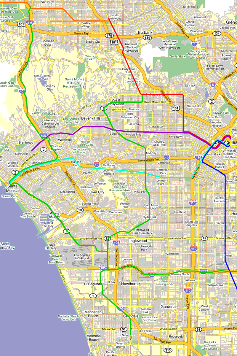 I assumed LRT could follow the west side of the 405 through Sepulveda Pass, the median of Lincoln Blvd., and parts of the medians of San Vicente and Santa Monica Blvds. I presumed track sharing on Expo west of the 405. 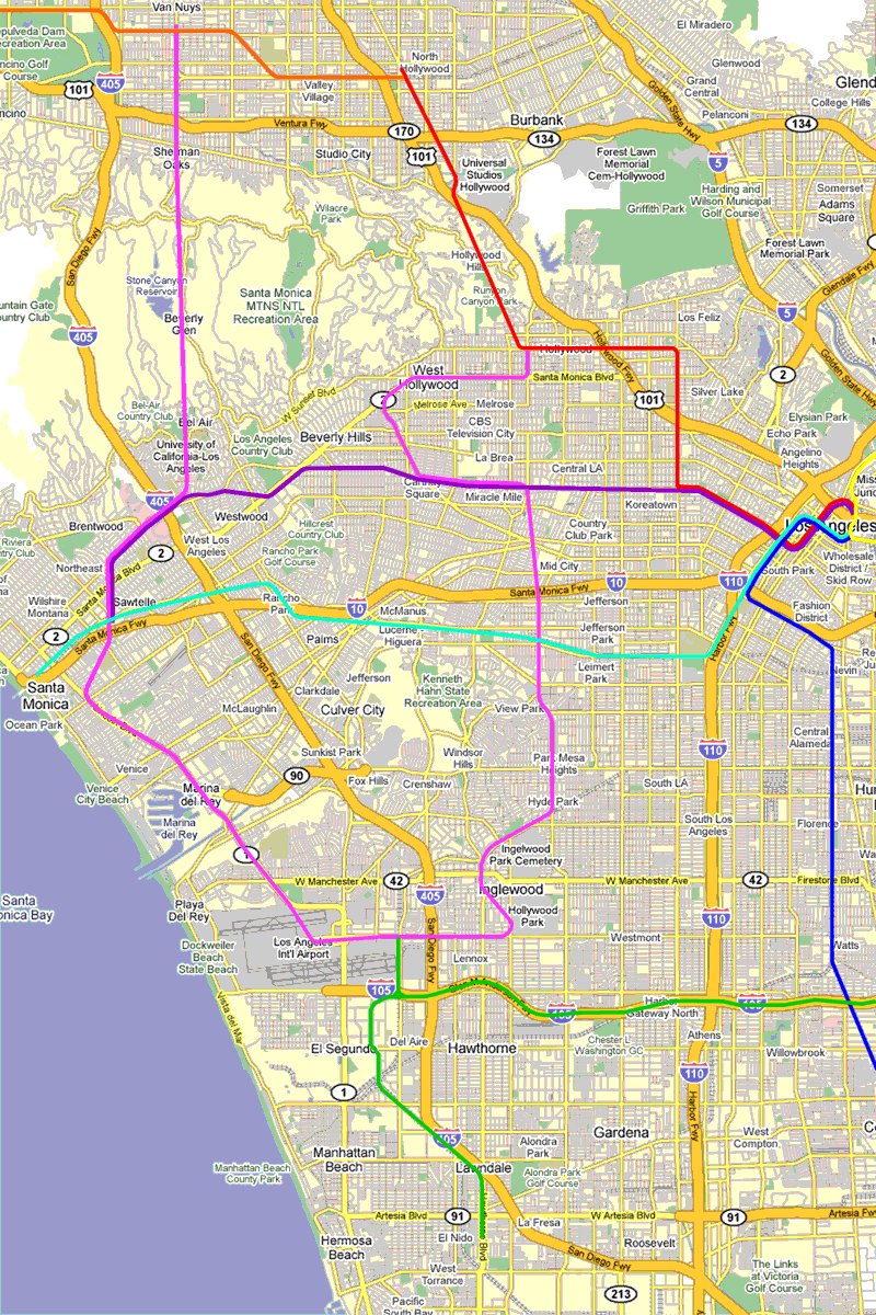 I took advantage of subway's ability to not follow streets in crossing the Santa Monica Mountains, the City of Santa Monica, LAX, and Crenwhaw north of Expo. I presumed track sharing between Westwood and an Expo transfer station at Bergamot Station, and in the Wilshire corridor (in the opposite direction of the Pink Line going to Santa Monica). But Crenshaw is now a given as LRT. |
|
|
|
Post by bobdavis on Apr 4, 2010 23:06:56 GMT -8
That subway line under the Santa Monica Mountains--how far would it be between stations on the non-stop stretch. Would it be longer than the West Oakland-Embarcadero underwater run of the BART system? Claustrophobia, anyone?
|
|
|
|
Post by kenalpern on Apr 5, 2010 20:14:54 GMT -8
Credit goes where credit is due, Darrell! Methinks you'll see one or both of them in Friday's Citywatch article, and I will certainly give you credit for these two awesome maps!
Thanx!
|
|
|
|
Post by darrell on Apr 5, 2010 20:33:56 GMT -8
That subway line under the Santa Monica Mountains--how far would it be between stations on the non-stop stretch. Would it be longer than the West Oakland-Embarcadero underwater run of the BART system? Claustrophobia, anyone? Measured on Google Maps the distance between the San Francisco Embarcadero and West Oakland BART stations is about 5.6 miles. Universal City to Hollywood & Highland on the Red Line is half that: about 2.8 miles. A straight tunnel from Van Nuys & Ventura Blvds. to central UCLA (I'd put a station there) would be about 5.4 miles. To Wilshire & Veteran is about 6.2 miles. I recall from the High Speed Rail planning that the cost of boring a tunnel goes up beyond 5 miles, but this would be do-able. I'd like to compare the cost of following Sepulveda Pass, though. |
|
|
|
Post by darrell on Apr 5, 2010 20:34:38 GMT -8
Credit goes where credit is due, Darrell! Methinks you'll see one or both of them in Friday's Citywatch article, and I will certainly give you credit for these two awesome maps! Thanx! I'll look forward to reading it, Ken! |
|
|
|
Post by bobdavis on Apr 6, 2010 10:50:52 GMT -8
The idea of a straight-shot tunnel with a distance comparable to BART's underwater tubes is appealing. No slowing for curves, no climbing grades, much less property acquisition hassle. The one "X" factor would be geology: what kind of rock structures would be encountered? The Cahuenga Pass tunnel might provide some indication, depending on how consistent the rocks are from east to west. The project that sticks in the back of my mind is the Newhall tunnel on the Metrolink Antelope Valley line. This was an engineering horror story, with many delays and some fatalities. Granted, it was dug over 130 years ago, and tunnel construction technology has improved by a large factor, but nasty geological conditions can still make a job miserable.
|
|
|
|
Post by erict on Apr 6, 2010 10:56:35 GMT -8
I know it's off subject, but I would hope that the 405 line (in the century that it is built) has a Getty Center stop.
|
|
|
|
Post by metrocenter on Apr 6, 2010 12:21:52 GMT -8
I think the 405 line should be along the eastern side of the 405. There is no space on th west side of the freeway along Sawtelle for anything. So on the west side would be much trickier. On the east side, however, Cotner Avenue would be an ideal location for an elevated train.
|
|
|
|
Post by masonite on Apr 6, 2010 12:48:29 GMT -8
I know it's off subject, but I would hope that the 405 line (in the century that it is built) has a Getty Center stop. I personally hope this is a tunnel project. Just think if you had a connection from the Orange Line to UCLA campus in 5 minutes via a straight tunnel with no stops. Westwood would be the next stop in say 7 minutes total. This would blow away any times from car travel and garner very high ridership. It might cost a lot more than the $1B that Measure R gives the project but given that they would only really need one new underground station at UCLA, the cost of building stations would be limited. I assume the Orange Line station could be above ground and the Westwood station would have already been built for the Purple Line. One problem is that if this were light rail it would be need to go to Expo to make use of their maintenance facility. In regards to the Getty, when it first opened parking was a real problem and if you wanted to go you had to take the 14 BBB, which was packed on the Sat. I went. Of course, after the newness wore off, the crowds went away and parking was not an issue. The BBB 14 doesn't even go to the Getty any more due to apparent lack of ridership. |
|
|
|
Post by erict on Apr 6, 2010 15:10:42 GMT -8
Now I see where it's going, under Beverly Glenn, not the 405. UCLA and Ventura Blvd. (Sherman Oaks) would seem to be important stops to me.
|
|
|
|
Post by masonite on Apr 6, 2010 16:39:18 GMT -8
Now I see where it's going, under Beverly Glenn, not the 405. UCLA and Ventura Blvd. (Sherman Oaks) would seem to be important stops to me. You're right. Ventura should have a stop as well so that would be two new subway stations. |
|
|
|
Post by kenalpern on Apr 6, 2010 21:15:33 GMT -8
I envision the 405 line to be a logical sequel of the Wilshire Subway, and considering that even a light rail would go over $1 billion that a tunnel is the only logical way to proceed. I definitely agree that UCLA would need a central station, and unless there is a way for the Bel Air/Getty Center region to agree to shuttle connections and parking there is no need to have any station between the Orange Line and UCLA unless we have a Sherman Oaks/Ventura stop.
UCLA and Sherman Oaks strikes me as the smartest two stops, and therefore a tunnel which would zoom from the Valley to the Westside would be one hellaciously-attractive ride (why would anyone accessing the Wilshire Corridor or Downtown want to take their car?).
I'd want some pretty kick-butt parking at Ventura Blvd and the Orange Line, though, because this would be a bigtime commuter rail-type connection for Valley and Westsiders to access each other's regions.
|
|
|
|
Post by jeisenbe on Apr 7, 2010 18:42:22 GMT -8
Ken, the solution to parking on the Sepulveda pass line is to continue it north and south. Travels from farther north in the valley could take an east-west bus to the nearest train station and zip south to the Westside in a few minutes. If the line is continued south of Westwood along Sepulveda to LAX, you would be able to connect with the future light rail line down the Harbor Subdivision, or transfer to Expo or the Green Line, or rapid buses on Venice and other main streets, for trips east and west.
In the short term we could have some parking along the Orange Line, until the rail line is extended further north in the Valley. But long term Metro needs to get away from park-and-ride planning, if it wants to build transit ridership and improve the city.
I do have a friend who works with robotic parking systems, which can park 3 times as many cars in the same volume, and work in underground and elevated structures. He thinks we need more park-and-rides. But unless people want to pay 10 to 20 bucks per day to park, it wouldn't be cost-effective. To make parking work for Metro, we need to get cities like Santa Monica, Long Beach and Los Angeles to get downtown parking up to a fair market price of $20 a day or more. As long as downtown parking is cheap, and freeways are free, people from the suburbs will mainly keep driving, even if we build a great subway under the Sepulveda pass.
|
|
|
|
Post by JerardWright on Apr 8, 2010 11:30:13 GMT -8
I think the 405 line should be along the eastern side of the 405. There is no space on th west side of the freeway along Sawtelle for anything. So on the west side would be much trickier. On the east side, however, Cotner Avenue would be an ideal location for an elevated train. That's the way I've envisioned it as using the terrain to our advantage and build a shelf on the eastside of the 405 and north of Mullholland, the line can dip into a tunnel and continue north to meet with Ventura/Sepulveda an actual ridership draw and destination without needing a large Park-ride and then continue north under Sepulveda Blvd to the 405/Sepulveda Orange Line Station -where there's an existing under utilized massively large park-ride- even possibly turning east and come to at-grade or as an aerial structure and end at Van Nuys Blvd. Maybe if this is done as LRT can be the start of upgrading the Orange Line Busway to Rail?The small issue that will need to be addressed with tunneling through the Sepulveda Pass which is twice as long as the Red Line tunnel through the Cauhenga are ventilation shafts. Where are the locations to put them? And if you can't put them along the tunnel, would we need a large ventilation plant like its done for the Chunnel? Could that work in Bel Air north of UCLA? Could that work on the other end south of Ventura and Van Nuys as some have suggested? One problem is that if this were light rail it would be need to go to Expo to make use of their maintenance facility. That would have an added benefit as it will ensure solid ridership for patrons needing to work at the Watergarden or in Downtown Santa Monica with just one transfer (or wishful thinking a direct tie-in to Expo Line). |
|
|
|
Post by erict on Apr 8, 2010 15:33:03 GMT -8
I don't think you can run light rail trains on heavy rail tracks, but other than that the line could be light rail with transfer points. It would need to be mostly underground through Hollywood/Weho, so it would be a subway anyhow.
|
|
|
|
Post by tobias087 on Apr 8, 2010 19:30:52 GMT -8
I would hope though that the 405 line would be a light rail subway, so it could hook up with the Green Line (in a far-flung future) 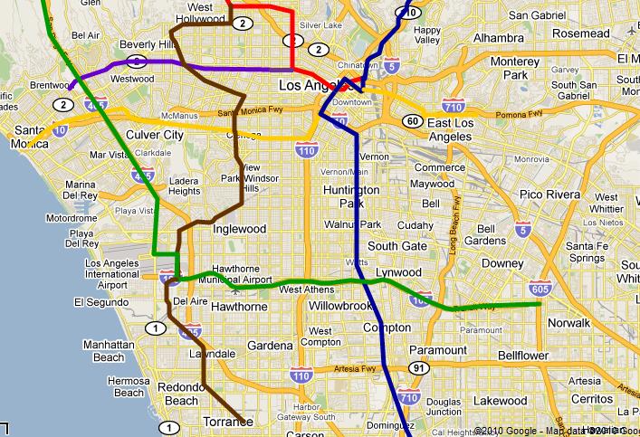 The brown line here would also be light rail, from the South Bay to Hollywood, like I mentioned earlier. |
|
|
|
Post by Philip on Apr 8, 2010 23:10:15 GMT -8
Based on what we've seen and how we should plan this line for the future, it's my humble opinion that the I-405 line should be built as a light-rail subway through the Sepulveda pass. I would also advocate, that the line be built in the following Phases:
Phase 1: Ventura/Sepulveda to Westwood - With stops at Ventura/Sepulveda, the Getty Center, UCLA, and Westwood (with a future Purple Line connection). It might be argued that the northern terminus should be at the Orange Line Sepulveda Station, but I would argue it's not the right spot (see Phase 3).
Phase 2: Westwood to LAX - Without a doubt the most expensive Phase of the line. Stops would include Sepulveda/Expo (with a future Expo Line connection) and of course, LAX (with future connections to the Green and Crenshaw Lines). Other stops in between may vary, although some likely areas would be, but are not limited to: Sepulveda/Palms, Sepulveda/Venice, Sepulveda/Centinella, and Sepulveda/Manchester.
Phase 3: Ventura/Sepulveda to Van Nuys Metrolink - Here's where things change a little. Rather than continue the line up Sepulveda, the line veers east and continues either above or underneath Van Nuys Blvd. Sepulveda would not be a bad place to run the line, but the density just isn't there like it is on Van Nuys. Plus, running the line under Van Nuys Blvd. makes for an easy connection to the Van Nuys Metrolink station. Stops would include Van Nuys/Ventura, Magnolia, Busway (for an Orange Line connection), and finally, the Metrolink station.
Future phases could allow the line to continue north all the way to Sylmar, or south to perhaps serve other areas not already served with the Green and Crenshaw Lines (though I cannot think of any off the top of my head).
|
|
|
|
Post by tobias087 on Apr 8, 2010 23:50:37 GMT -8
I agree with you Philip, although based on the above posts concerning demand, and the difficulty of reconciling the tunnel approach with a Getty Center station, I would cut that, and instead plan for a bus connection.
Also, while I agree that Ventura and Sepulveda will make a better stop than Sepulveda and the Orange Line, there ought to be an Orange Line connection somewhere! I would suggest including Van Nuys and the Orange Line as your terminus in Phase 1, and going from there. It will be interesting to see how timing and funding for a plan like your Phase 3 would conflict with the current plan to study a median busway on Van Nuys blvd...
|
|
|
|
Post by Philip on Apr 9, 2010 0:03:38 GMT -8
I just re-checked the intersections of Van Nuys/Busway and Van Nuys/Victory on Google Maps. Victory would definitely be connected to more businesses, but the difference between them seems minimal. I must concede that for connectivity and if the Orange Line ever is converted to rail, that the Busway would be a better stop than Victory. I've re-edited Phase 3 accordingly. Cheers, Tobias!
|
|
|
|
Post by wad on Apr 9, 2010 4:01:45 GMT -8
I don't think you can run light rail trains on heavy rail tracks ... . You can run light rail trains on heavy rail tracks. All Metro Rail vehicles are standard rail gauge. You can't run light rail trains in heavy rail tunnels, and the other way around. The first issue is the power source (overhead vs. third rail). Second, the subway cars are shorter and wider than light rail cars. |
|
|
|
Post by tonyw79sfv on Apr 9, 2010 7:00:17 GMT -8
I agree with you Philip, although based on the above posts concerning demand, and the difficulty of reconciling the tunnel approach with a Getty Center station, I would cut that, and instead plan for a bus connection. Also, while I agree that Ventura and Sepulveda will make a better stop than Sepulveda and the Orange Line, there ought to be an Orange Line connection somewhere! I would suggest including Van Nuys and the Orange Line as your terminus in Phase 1, and going from there. It will be interesting to see how timing and funding for a plan like your Phase 3 would conflict with the current plan to study a median busway on Van Nuys blvd... The median busway on Van Nuys Boulevard was a suggestion from LADOT due to the corridor being identified in Measure R for SFV north/south rapid transit, however, it is assumed that this would be done with buses. It's not set in stone yet as whether buses would have dedicated lanes or go all out "Orange Line"-sytle on Van Nuys. One thing for certain, with 7 - 10 minute rush hour frequencies and the use of NABI 60BRT buses, Van Nuys warrants whatever high capacity rapid transit line needed. I just re-checked the intersections of Van Nuys/Busway and Van Nuys/Victory on Google Maps. Victory would definitely be connected to more businesses, but the difference between them seems minimal. I must concede that for connectivity and if the Orange Line ever is converted to rail, that the Busway would be a better stop than Victory. I've re-edited Phase 3 accordingly. Cheers, Tobias! Rather than Van Nuys/Victory, I'd prefer Van Nuys/Sherman Way as an addition station between the Orange Line and Metrolink/Amtrak station. If possible, the line should go into Panorama City, it's more dense than North Hollywood. |
|
|
|
Post by masonite on Apr 9, 2010 9:17:25 GMT -8
Based on what we've seen and how we should plan this line for the future, it's my humble opinion that the I-405 line should be built as a light-rail subway through the Sepulveda pass. I would also advocate, that the line be built in the following Phases: Phase 1: Ventura/Sepulveda to Westwood - With stops at Ventura/Sepulveda, the Getty Center, UCLA, and Westwood (with a future Purple Line connection). It might be argued that the northern terminus should be at the Orange Line Sepulveda Station, but I would argue it's not the right spot (see Phase 3). Phase 2: Westwood to LAX - Without a doubt the most expensive Phase of the line. Stops would include Sepulveda/Expo (with a future Expo Line connection) and of course, LAX (with future connections to the Green and Crenshaw Lines). Other stops in between may vary, although some likely areas would be, but are not limited to: Sepulveda/Palms, Sepulveda/Venice, Sepulveda/Centinella, and Sepulveda/Manchester. Phase 3: Ventura/Sepulveda to Van Nuys Metrolink - Here's where things change a little. Rather than continue the line up Sepulveda, the line veers east and continues either above or underneath Van Nuys Blvd. Sepulveda would not be a bad place to run the line, but the density just isn't there like it is on Van Nuys. Plus, running the line under Van Nuys Blvd. makes for an easy connection to the Van Nuys Metrolink station. Stops would include Van Nuys/Ventura, Magnolia, Busway (for an Orange Line connection), and finally, the Metrolink station. Future phases could allow the line to continue north all the way to Sylmar, or south to perhaps serve other areas not already served with the Green and Crenshaw Lines (though I cannot think of any off the top of my head). I am right there with you. This would be a fantastic line if it went all the way from Sylmar and the CAHSR station to the South Bay. It would be as much of a feeder line as a destination line, but that is what is needed for North-South transport when we will have solid lines in Green, Expo, Purple, and even Orange. It would be a destination line in that Ventura Blvd., UCLA, Westwood, and LAX are major destinations in their own right. One stat that always surprises people is that Westwood has a higher working population than all of Downtown San Diego. Of course, the big problem is that this sucker will be hugely expensive. I still think that this idea will gain traction in future years as people in the SFV, South Bay and Westside realize how much it is really needed and would benefit major portions of the County. |
|
|
|
Post by Philip on Apr 9, 2010 10:32:13 GMT -8
The one saving grace is that the first Phase (Ventura to Westwood) will be less expensive than the other two. It will still cost close to $1 billion dollars, but Measure R already provides that. It's possible that one of the stations (most likely the Getty Center's) may have to be sacrificed to keep the cost of this Phase down. That would be a huge disappointment, as I'm sure the lack of a Getty Center stop will cost a large number of riders. However, a well-timed and frequent shuttle bus, from perhaps the UCLA and Ventura Blvd. stops, could mitigate this problem.
I'm in full agreement about a stop on Sherman Way as well.
While the line will be expensive, its importance in plugging a major transit gap in our system cannot be underestimated. Phase 1 alone, if built in the way that I've described, will be a huge boon to the system and generate a large ridership. One of the biggest complaints I always hear (mostly from people who are uninformed) is that the L.A. metro system doesn't go anywhere/go anywhere fast enough to give people incentives to leave their cars.
But getting from Sherman Oaks to the Westside in <15 minutes without driving? That's going to make EVERYONE'S head perk up, even those that may feel ambivalent towards transit (much in the same way that I feel the Expo Line will once it finally opens).
|
|
|
|
Post by bobdavis on Apr 9, 2010 10:46:56 GMT -8
As far as running light-rail trains in subways--Boston has been doing it for over a hundred years (Green Line). Boston also has the Blue Line, with cars powered by both third rail and overhead wire. Whether the LA subway configuration (Red/Purple line) has enough overhead clearance to add trolley wire and accommodate pantographs might be a question, but remember that the first mile or so of the Blue Line is a subway, and the Gold Line tunnels under Figueroa St. and Colorado Blvd. The one real sticking-point is the loading gauge: To run current-design LA light rail cars in the current subway would require either gantlet tracks to shift the narrower cars closer to the platform or adjustable platform edges that would move out to close the gap.
|
|
|
|
Post by jdrcrasher on Apr 9, 2010 18:03:45 GMT -8
Running the subway into the valley isn't smart. We need to develop a grid, not a spider-like system.
|
|
|
|
Post by Philip on Apr 10, 2010 10:00:55 GMT -8
Running the subway into the valley isn't smart. We need to develop a grid, not a spider-like system. Forgive my ignorance, but you mind elaborating a bit? Very few systems, if you look at them carefully, follow a perfect grid. There's huge ridership potential in the valley and it would be foolish to deprive it of rapid transit. |
|
|
|
Post by jdrcrasher on Apr 10, 2010 11:26:29 GMT -8
Forgive my ignorance, but you mind elaborating a bit? Very few systems, if you look at them carefully, follow a perfect grid. There's huge ridership potential in the valley and it would be foolish to deprive it of rapid transit. I'm not suggesting we "deprive" the valley, i'm suggesting we look at the larger picture. The Harbor Subdivision project (DTLA-Inglewood-LAX-Redondo-Long Beach) is going to use the right of way south of LAX to get to Long Beach. And it is planned on being Light-Rail. Why not link the 405 and Harbor Subdivision corridors together? We need a grade-separated 405 Light-Rail corridor from the Sylmar Metrolink station to Long Beach, instead of a purple line subway extension simply into the valley to Sylmar. At 55 Mph, it wouldn't be that much slower than a 70 Mph subway extension, making the 48 mile trip from Sylmar to Long Beach in approximately an hour, when stops are included. That's not too shabby, considering how hard it is to commute on the 405 Freeway. If we were to make the 405 corridor a subway, it would all but kill a full 405 corridor option, because we simply can't have 2 modes of transportation on the same right of way South of LAX, going to the same stops . Not only is that politically impossible, but it just doesn't make any sense. Besides, Santa Monica is one of the densest places in LA county, so having both the Purple and Expo Lines head there while coming from different areas isn't a bad thing. If anything, it's a good thing, because now even more car traffic can be reduced in this heavily congested city. |
|


