|
|
Post by davebowman on May 22, 2012 9:22:01 GMT -8
The intersection of Olympic Blvd. and Cloverfield in Santa Monica was messed up this morning. The left-turn arrow for the WB Olympic to the SB Cloverfield stayed red for a long, long time, and eventually cars had to pull out of the left turn lanes and find a detour. I'm guessing this had something to do with the construction crew working at the SW corner of the intersection. There was also a guy spraying something in the ROW cutting across the median just west of the intersection. When I finally got on the 10 East heading downtown the WB traffic was even worse than usual, practically at a standstill leading to the Cloverfield/26th St. exit, so there may have been a problem with other signals as well.
Does anyone know if this is going to be an ongoing problem during Phase 2 construction? Should the Olympic/Cloverfield intersection be avoided if at all possible?
|
|
|
|
Post by bzcat on May 22, 2012 9:58:15 GMT -8
Or it could be just a bad sensor under the pavement. Doesn't have to be Expo related at all. Those coils embedded in the pavement to tell the lights to change fail and need to replaced regularly.
|
|
|
|
Post by joshuanickel on May 22, 2012 12:55:48 GMT -8
Santa Monica is currently upgrading the traffic signals along Olympic Blvd so the traffic signals all along Olympic are screwed up right now.
|
|
|
|
Post by Philip on May 22, 2012 21:22:56 GMT -8
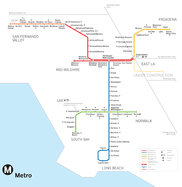
Some changes I hope we get to some of the Phase 2 station names -
Expo/Westwood -- Rancho Park
17th/Colorado -- Santa Monica Memorial Park
4th/Colorado -- Santa Monica Pier & Promenade
|
|
|
|
Post by antonio on May 22, 2012 23:05:19 GMT -8
I agree with all of those choices with the addendum that you add /SMC to Santa Monica Memorial Park. I would also add that Palms/National be shortened to Palms and 26th/Olympic be named Bergamot Station.
|
|
|
|
Post by antonio on May 22, 2012 23:09:35 GMT -8
...and to make Santa Monica Memorial Park/SMC less unwieldy change the name of the Gold Line Memorial Park station to Old Town Pasadena to avoid confusion and just call it Memorial Park/SMC
|
|
|
|
Post by Philip on May 22, 2012 23:13:08 GMT -8
I agree with all of those choices with the addendum that you add /SMC to Santa Monica Memorial Park. I would also add that Palms/National be shortened to Palms and 26th/Olympic be named Bergamot Station. I see your points. I think 17th/Colorado should be either SM Memorial Park or SM College because I think using both would make the station name far too long. Since Memorial Park is where the station is (SM College is a short distance farther), I would defer to that. I like the idea of Bergamot as well, but I feel 26th/Olympic would make more sense to riders and tourists. How many people (outside nearby residents) would actually know what "Bergamot" even is? |
|
|
|
Post by carter on May 22, 2012 23:22:16 GMT -8
Some changes I hope we get to some of the Phase 2 station names - Expo/Westwood -- Rancho ParkMy one reason to disagree is that Westwood Blvd. has a number of very busy bus lines running on it and will be a major bus transfer point. So having the name Westwood in it provides that additional wayfinding clue. |
|
|
|
Post by Gokhan on May 23, 2012 0:23:45 GMT -8
Some changes I hope we get to some of the Phase 2 station names - Expo/Westwood -- Rancho ParkMy one reason to disagree is that Westwood Blvd. has a number of very busy bus lines running on it and will be a major bus transfer point. So having the name Westwood in it provides that additional wayfinding clue. Also, the Rancho Park "Park" is located at Pico and Motor... |
|
|
|
Post by Gokhan on May 23, 2012 0:29:43 GMT -8
Balfour Beatty Infrastructure, who is virtually done with the Culver City work, has now started the work for the Venice Blvd bridge. The initial work will be to relocate a large sewer under Venice and will take four months. The necessary I beams, steel plates, etc. for shoring have been brought to the right-of-way there.
Once this is done, some of the supports can go in. Not all supports can go in until the overhead wires are relocated underground. Once all the supports go in, they can put the falsework and make the forms and steel rebars and pour concrete. I don't expect this to take place at least a year or two from now because of the overhead wires, which will take a long time to be redesigned for underground relocation.
|
|
|
|
Post by fissure on May 23, 2012 8:54:44 GMT -8
Some changes I hope we get to some of the Phase 2 station names - Expo/Westwood -- Rancho Park17th/Colorado -- Santa Monica Memorial Park4th/Colorado -- Santa Monica Pier & PromenadeNot sold on the specifics, but couldn't agree more. It feels silly to have the transit system linking a bunch of arbitrary intersections instead of places/neighborhoods. It optimizes for people who know the street grid well but don't take transit, which I think is a small percentage compared to those taking transit regularly and tourists that don't know the area at all. |
|
|
|
Post by Elson on May 23, 2012 12:21:08 GMT -8
Some changes I hope we get to some of the Phase 2 station names - Expo/Westwood -- Rancho Park17th/Colorado -- Santa Monica Memorial Park4th/Colorado -- Santa Monica Pier & PromenadeNot sold on the specifics, but couldn't agree more. It feels silly to have the transit system linking a bunch of arbitrary intersections instead of places/neighborhoods. It optimizes for people who know the street grid well but don't take transit, which I think is a small percentage compared to those taking transit regularly and tourists that don't know the area at all. I would beg to differ in certain circumstances. I think some intersections are a well-known place unto themselves (Hollywood/Vine being arguably the most famous intersection in the entire world), and if they serve a multitude of destinations, it's best to just stick to the intersection to be "neutral." I do think there's also justification to name "slash" a station name if its cross-street is duplicated elsewhere in the Metro Rail system, like Expo/Western, Wilshire/Western, Hollywood/Western. I do think Expo/Westwood is important since it's going to be the closest station to the actual Westwood for a number of years, also most people who live near there consider their community to be "Cheviot Hills." I think Colorado/17th should just be "17th Street" since there's no other 17th street stations on the Metro system. Calling it "Santa Monica Memorial Park" is also confusing since it's also in close proximity to a cemetery. It's roughly the same distance from SMC as the Gold Line Allen station is from PCC. I do agree that the terminus should be either "Santa Monica Pier" or "Santa Monica Beach." Tourists will not know what "Colorado/4th" means when they spot it on the map. The pier's entrance is easily within sight of the station. |
|
|
|
Post by Philip on May 23, 2012 14:00:44 GMT -8
I think we're all in agreement that 4th/Colorado needs to be changed.
I like "Santa Monica Pier & Promenade" better than just "Santa Monica Pier" because the station itself will be physically closer to the Promenade (but also a short distance from the Pier entrance).
|
|
|
|
Post by Elson on May 23, 2012 16:18:10 GMT -8
I think we're all in agreement that 4th/Colorado needs to be changed. I like "Santa Monica Pier & Promenade" better than just "Santa Monica Pier" because the station itself will be physically closer to the Promenade (but also a short distance from the Pier entrance). Be aware that no Metro station uses an ampersand ("&") in its name, only slashes. So that will never happen. Also, in the automatic station call announcements, it would sound like, "Santa Monica Peerin' Promenade." The announcement would probably say: "Now arriving, [station name]. End of the line. Exit here for: Santa Monica Pier, 4th Street Promenade, Santa Monica Civic Center and Santa Monica Beach. Please take all your belongings with you...Thank you for riding Metro Rail." |
|
|
|
Post by bzcat on May 23, 2012 17:15:18 GMT -8
I do think Expo/Westwood is important since it's going to be the closest station to the actual Westwood for a number of years, also most people who live near there consider their community to be "Cheviot Hills." Actually no. The Expo/Westwood station is located in the Rancho Park neighborhood, not Cheviot Hills. The Palms/National station is actually located in Cheviot Hills (and not in Palms proper). I prefer Midtown Santa Monica but I know that will never fly. 4th Street should be Downtown Santa Monica. Clear, descriptive, and geographically correct. Promenade, Pier etc are all fine destinations in or near Downtown Santa Monica. |
|
|
|
Post by carter on May 23, 2012 22:24:18 GMT -8
4th Street should be Downtown Santa Monica. Clear, descriptive, and geographically correct. Promenade, Pier etc are all fine destinations in or near Downtown Santa Monica. This one gets my vote of approval. |
|
|
|
Post by bluelineshawn on May 24, 2012 5:22:03 GMT -8
Not sold on the specifics, but couldn't agree more. It feels silly to have the transit system linking a bunch of arbitrary intersections instead of places/neighborhoods. It optimizes for people who know the street grid well but don't take transit, which I think is a small percentage compared to those taking transit regularly and tourists that don't know the area at all. I would beg to differ in certain circumstances. I think some intersections are a well-known place unto themselves (Hollywood/Vine being arguably the most famous intersection in the entire world), and if they serve a multitude of destinations, it's best to just stick to the intersection to be "neutral." I do think there's also justification to name "slash" a station name if its cross-street is duplicated elsewhere in the Metro Rail system, like Expo/Western, Wilshire/Western, Hollywood/Western. I do think Expo/Westwood is important since it's going to be the closest station to the actual Westwood for a number of years, also most people who live near there consider their community to be "Cheviot Hills." I think Colorado/17th should just be "17th Street" since there's no other 17th street stations on the Metro system. Calling it "Santa Monica Memorial Park" is also confusing since it's also in close proximity to a cemetery. It's roughly the same distance from SMC as the Gold Line Allen station is from PCC. I do agree that the terminus should be either "Santa Monica Pier" or "Santa Monica Beach." Tourists will not know what "Colorado/4th" means when they spot it on the map. The pier's entrance is easily within sight of the station. Finally an ally!  We have a sophisticated road network built on a grid where every point is easily identifiable allowing easier travel, yet most advocates prefer that stations be named after neighborhoods that anyone more than a few miles away would struggle to identify. I never heard of Cheviot Hills prior to Expo, never heard of Rancho Park before now, and couldn't place half of the neighborhoods suggested over the years. I can't fathom the preference for a naming convention that does not aid wayfinding for most people for some perceived aesthetic benefit. In many cases neighborhood names will make sense, but not usually. |
|
|
|
Post by Gokhan on May 24, 2012 8:25:56 GMT -8
I do think Expo/Westwood is important since it's going to be the closest station to the actual Westwood for a number of years, also most people who live near there consider their community to be "Cheviot Hills." Actually no. The Expo/Westwood station is located in the Rancho Park neighborhood, not Cheviot Hills. The Palms/National station is actually located in Cheviot Hills (and not in Palms proper). The National/Palms Station is strictly in Palms -- Palms proper if you like. Palms, established in 1886, was the oldest city outside LA (then only what is Downtown today) until it was annexed by LA in 1915, and the Palms Station, located at Vinton Ave and National Blvd, was the oldest station on the original line. See the official map of Palms. It's no-brainer that National/Palms should be changed to Palms and the Palms Neighborhood Council has already submitted a request to Expo Authority.The area north of the freeway there is not Cheviot Hills by the way -- it's Castle Heights. Cheviot Hills is further northwest. The reason some businesses refer to it as Cheviot Hills is the same as a lot of businesses in Beverly-Hills-adjacent locations referring to themselves as Beverly Hills businesses -- false yet slick marketing. I do support neighborhood names unless they are obscure. The Westwood Station is neither in Cheviot Hills nor in Rancho Park. The Westwood Station is actually in " Westwood Gardens." It would be great if they could it name it to that but I am fine with Expo/Westwood too. Westwood Gardens would be great considering that they will build a park and creek next to the station.  |
|
|
|
Post by Dan Wentzel on May 24, 2012 8:40:10 GMT -8
London names their stations after neighborhoods, not intersections and I'd be in favor of that.
|
|
|
|
Post by bhowald on May 24, 2012 9:30:20 GMT -8
Gokhan, while you are correct that Palms/National is in Palms, and not in Cheviot Hills, the map you posted only shows the boundaries of the Cheviot Hills Homeowners' Association.
The California Country Club Estates is another homeowners' association in Cheviot Hills that represents the homes that are located in what was the California Country Club until the mid-1950s.
As a former resident of Cheviot Hills (Club Drive, to be specific), I assure you that Cheviot Hills is larger than the area shown in the map. Cheviot Hills also includes (roughly) the homes north and west of National Blvd, but also west of Shelby Drive, and Beverwill Avenue.
|
|
|
|
Post by Gokhan on May 24, 2012 10:20:37 GMT -8
Gokhan, while you are correct that Palms/National is in Palms, and not in Cheviot Hills, the map you posted only shows the boundaries of the Cheviot Hills Homeowners' Association. The California Country Club Estates is another homeowners' association in Cheviot Hills that represents the homes that are located in what was the California Country Club until the mid-1950s. As a former resident of Cheviot Hills (Club Drive, to be specific), I assure you that Cheviot Hills is larger than the area shown in the map. Cheviot Hills also includes (roughly) the homes north and west of National Blvd, but also west of Shelby Drive, and Beverwill Avenue. You're right in that Cheviot Hill is bigger. Unfortunately Castle Heights doesn't have their map yet but according to their site, Shelby, Provon, and Vicar are in Castle Heights. The area south of I-10 is definitely Palms ( map). There are also two other neighborhoods in the immediate vicinity there called Beverlywood and South Robertson. Speaking of Balkanization. I remember in one of the Cheviot Hills HOA meetings, a young woman referred to Palms as "the neighborhood to the south of us" with a very sour face and in a negative manner while the crime was being discussed with a police officer invited. You can't believe the ignorance of some of these people who look down on middle-class neighborhoods. There is probably more crime (drugs, major house burglaries) in Cheviot Hills than in Palms. |
|
|
|
Post by carter on May 24, 2012 10:45:10 GMT -8
London names their stations after neighborhoods, not intersections and I'd be in favor of that. But London is a medieval town where roads randomly dead-end, change directions and change names, so naming stations after intersections would not provide any useful information, whereas a neighborhood name would provide information. Los Angeles is quite different, in that knowing any two cross-streets often tells you almost everything about where you are in the city and what other transit services are nearby. Knowing that you're at "Expo/Western" immediately tells you that you can catch the Western Bus. Calling that station "Jefferson Park" doesn't give the typical transit rider any clues about their whereabouts or what connections are available. So my inclination is to support station names that reflect the intersections. However, I would support going away from this approach and using neighborhood names under two circumstances: 1) When this station is in a small, intact city where this is the only transit station (i.e. Culver City). 2) When the street grid is sufficiently non-grid-like that knowing the intersection wouldn't be very useful (i.e. Palms station because National Blvd and Expo curve around in a whole bunch of weird directions around there). 2) |
|
|
|
Post by rajacobs on May 24, 2012 10:55:52 GMT -8
Ditto to bhowald. Cheviot Hills Homeowners Assoc. is an association and doesn't reflect "Cheviot Hills" (either in attitude or boundaries).
The more appropriate boundatry for Cheviot Hills to the east is from Manning and National straight up Shelby Drive. Realtors refer to Palms, Rancho Park, Cheviot Hills, Beverlywood, and South Beverlywood--but, since these were never incorporated, their boundaries will always remain loose. As for Castle Heights Neighborhood Assoc. --Shelby, Provon, and Vicar are in the Castle Heights school district and hence would be included in the Castle Heights "neighborhood." ...But Castle Heights has never refered to a geographically identifiable area--only a school and the streets it serves!
But using the Cheviot Hills Homeowners Assoc. map for anything at all is misleading.
|
|
|
|
Post by Philip on May 24, 2012 11:00:38 GMT -8
The problem with switching 4th/Colorado to "Downtown Santa Monica" I see is that eventually, the Purple Line will make it's way to that area when it reaches 4th/Wilshire. To me, 4th/Wilshire makes for a better "Downtown Santa Monica" station, while the Colorado station is a better foil for the Pier name.
|
|
|
|
Post by bluelineshawn on May 24, 2012 11:24:42 GMT -8
London names their stations after neighborhoods, not intersections and I'd be in favor of that. They have a hodgepodge of stations named after neighborhoods, streets, and places. It makes sense for them, but not for us because we have an easily navigable grid and our bus routes mostly follow the grid. It sometimes makes sense but in general naming stations after neighborhoods makes as much sense as naming freeway off ramps after neighborhoods. It's homey, but doesn't really aid wayfinding. |
|
|
|
Post by masonite on May 24, 2012 12:10:25 GMT -8
London names their stations after neighborhoods, not intersections and I'd be in favor of that. But London is a medieval town where roads randomly dead-end, change directions and change names, so naming stations after intersections would not provide any useful information, whereas a neighborhood name would provide information. Los Angeles is quite different, in that knowing any two cross-streets often tells you almost everything about where you are in the city and what other transit services are nearby. Knowing that you're at "Expo/Western" immediately tells you that you can catch the Western Bus. Calling that station "Jefferson Park" doesn't give the typical transit rider any clues about their whereabouts or what connections are available. So my inclination is to support station names that reflect the intersections. However, I would support going away from this approach and using neighborhood names under two circumstances: 1) When this station is in a small, intact city where this is the only transit station (i.e. Culver City). 2) When the street grid is sufficiently non-grid-like that knowing the intersection wouldn't be very useful (i.e. Palms station because National Blvd and Expo curve around in a whole bunch of weird directions around there). 2) I'd add to that where the intersection name is actually somewhat misleading like Anaheim and Sierra Madre. Also, if the street is a small not heavily used intersection. As we have more lines, we may have to revisit some of the station names. For example if the Crenshaw Line goes to Hollywood some day and there is a Pico station, it wouldn't really make sense to have two Pico stations. The Expo/Blue Pico station would probably need to have its name changed to Staples/Convention Center. Overall, I tend to go for more neighborhood/place/landmark names. Maybe that is because I grew up some in DC where they have a very successful post war system that utilized them. I do understand the argument for intersections here although it is balanced out sometimes by people not realizing a landmark or neighborhood is next to an intersection when they see a street name. This is especially true for visitors. Anyway, we have talked this issue to death and everyone has strong opinions so there are good arguments to both sides. I do find the station announcements on our trains now do help mitigate the intersection names somewhat and are a great addition to the system, especially from the old days when on the Red Line you would really have to strain to hear an operator announce just the station name. |
|
|
|
Post by Elson on May 24, 2012 12:26:41 GMT -8
The problem with switching 4th/Colorado to "Downtown Santa Monica" I see is that eventually, the Purple will make it's way to that area when it reaches 4th/Wilshire. To me, 4th/Wilshire makes for a better "Downtown Santa Monica" station, while the Colorado station is a better foil for the Pier name. Do we know that yet? Metro hasn't planned that far. All we know is that the Purple Line will go as far west as the VA Medical Center. Anything beyond that has not been planned. Expo Line to Downtown SM HAS been planned, that is a certainty. Purple Line to SM is not a certainty. |
|
|
|
Post by Elson on May 24, 2012 12:32:08 GMT -8
London names their stations after neighborhoods, not intersections and I'd be in favor of that. They have a hodgepodge of stations named after neighborhoods, streets, and places. It makes sense for them, but not for us because we have an easily navigable grid and our bus routes mostly follow the grid. It sometimes makes sense but in general naming stations after neighborhoods makes as much sense as naming freeway off ramps after neighborhoods. It's homey, but doesn't really aid wayfinding. I would add to say that NYC's subway system names all their stations after streets or intersections. They, too have compound station names that add local landmarks (Union Sq-14 St). NYC does have duplicate station names on different lines, LA Metro is smart in avoiding that. Ironically, though Los Angeles sprawls like London, it is also an American city like NYC and is likewise built on a grid. |
|
|
|
Post by bzcat on May 24, 2012 15:12:27 GMT -8
The problem with switching 4th/Colorado to "Downtown Santa Monica" I see is that eventually, the Purple Line will make it's way to that area when it reaches 4th/Wilshire. To me, 4th/Wilshire makes for a better "Downtown Santa Monica" station, while the Colorado station is a better foil for the Pier name. We can worry about that when the Purple line actually get extended. And personally, I see no problem with both station being called Downtown Santa Monica. They are only 4 (tiny) blocks apart - and they are both physically located in Downtown. Wilshire Arizona Santa Monica Broadway Colorado There are 6 stations in Tokyo called Shinjuku... somehow they can manage just fine. We will be ok with 2 stations called Downtown Santa Monica. |
|
|
|
Post by bzcat on May 24, 2012 15:37:19 GMT -8
They have a hodgepodge of stations named after neighborhoods, streets, and places. It makes sense for them, but not for us because we have an easily navigable grid and our bus routes mostly follow the grid. It sometimes makes sense but in general naming stations after neighborhoods makes as much sense as naming freeway off ramps after neighborhoods. It's homey, but doesn't really aid wayfinding. I would add to say that NYC's subway system names all their stations after streets or intersections. They, too have compound station names that add local landmarks (Union Sq-14 St). NYC does have duplicate station names on different lines, LA Metro is smart in avoiding that. Ironically, though Los Angeles sprawls like London, it is also an American city like NYC and is likewise built on a grid. We don't need to stick with a rigid naming system. LA should adopt a flexible station naming system and stop defaulting to cross roads. I would propose that we roughly follow the naming scheme in this order of priority: 1. Famous landmarks (e.g USC Expo Park, Watts Tower, Civic Center) 2. Neighborhood names in common use (e.g Koreatown, Little Tokyo, Palms, North Hollywood, Century City) 3. Important cross roads with significant commercial activities/destination by itself without the rail station (e.g Hollywood Vine, Hollywood Highland, Wilshire La Brea) - note that names should be used without the slash " / ". 4. Single street names + descriptive nearby place of interest (7th St + Metro Center, Pico Blvd + Staples Center, Del Mar + Old Town Pasadena, 17th St + Midtown Santa Monica, Fairfax + LACMA, Westwood Blvd + Westside Pavilion) 5. Minor cross roads (Imperial/everything, Expo/everything) 6. Single street names without context (Mission, Fillmore, Indiana, Willow) 7. Single street names that could be misleading (Anaheim, Artesia, Sierra Madre Villa) |
|