|
|
Post by Gokhan on Oct 4, 2012 15:55:18 GMT -8
Dwight Sturtevant emailed me that the phase 2 column footings are with multiple CIDH piles like the abutments, not the single large CIDH piles of the phase 1 columns. He also passed along this 9/13/12 photo, taken from the Arboretum parking structure, showing excavated locations of two columns and rebar cages for their piles. 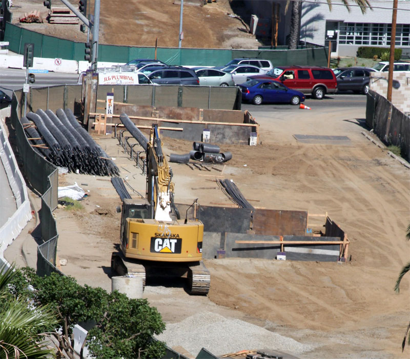 It makes me wonder if this technique had been used for phase 1 whether the double columns by Ballona Creek could have been single? You realize it's much cheaper this way -- using abutment-like columns with small CIDH piles rather than cylindrical, single-large-CIDH-pile columns -- but it's also less aesthetic, as they will be rather wide. It must be part of the strict cost-cutting measures in Phase 2, like not putting second entrances at National/Palms and Westwood Stations, which would really benefit the community. |
|
|
|
Post by Gokhan on Oct 4, 2012 15:56:51 GMT -8
They are pouring concrete for the retaining wall alongside National Boulevard and behind Price Self-Storage in Palms: 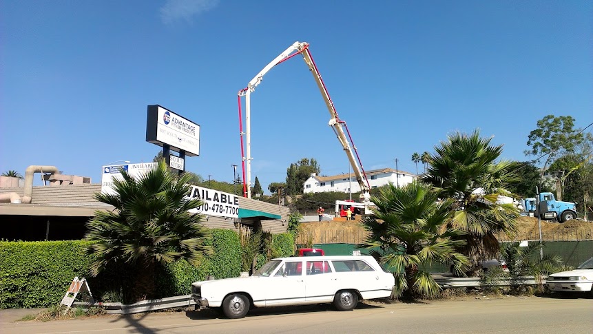 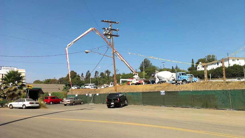 |
|
|
|
Post by darrell on Oct 4, 2012 16:44:51 GMT -8
Dwight Sturtevant emailed me that the phase 2 column footings are with multiple CIDH piles like the abutments, not the single large CIDH piles of the phase 1 columns. He also passed along this 9/13/12 photo, taken from the Arboretum parking structure, showing excavated locations of two columns and rebar cages for their piles. It makes me wonder if this technique had been used for phase 1 whether the double columns by Ballona Creek could have been single? You realize it's much cheaper this way -- using abutment-like columns with small CIDH piles rather than cylindrical, single-large-CIDH-pile columns -- but it's also less aesthetic, as they will be rather wide. It must be part of the strict cost-cutting measures in Phase 2, like not putting second entrances at National/Palms and Westwood Stations, which would really benefit the community. Although, this 5/9/11 Skanska elevation showed this would be a short retained-fill section between Cloverfield and Olympic. Are we sure it's not? 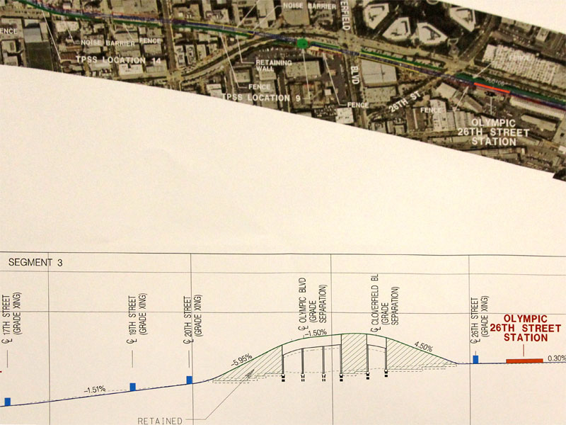 |
|
|
|
Post by Gokhan on Oct 4, 2012 22:12:52 GMT -8
OK, that makes more sense. It would be rather bizarre to have such a large deviation from the Phase 1 engineering and architecture otherwise.
|
|
|
|
Post by darrell on Oct 4, 2012 23:25:47 GMT -8
OK, that makes more sense. It would be rather bizarre to have such a large deviation from the Phase 1 engineering and architecture otherwise. Although Dwight just emailed me a link to these apparently-more-recent plan and profile drawings that only show columns. 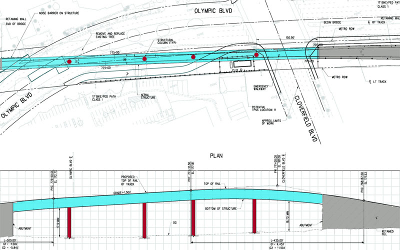 |
|
|
|
Post by darrell on Oct 4, 2012 23:32:19 GMT -8
These three Skanska images appeared on Curbed LA yesterday. Perhaps for the Urban Design Committee? 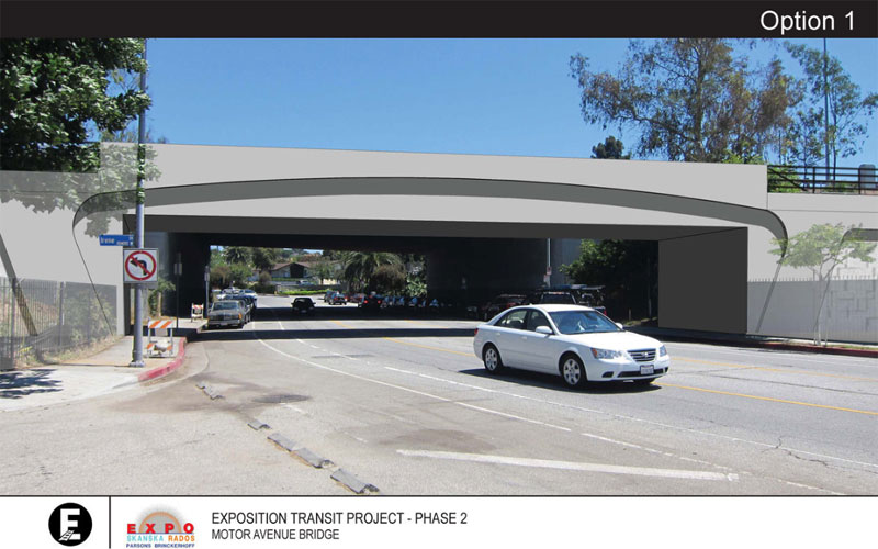 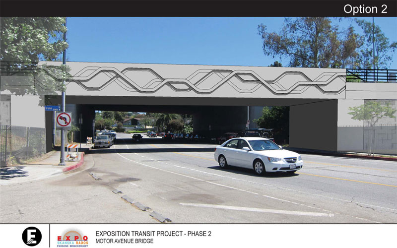 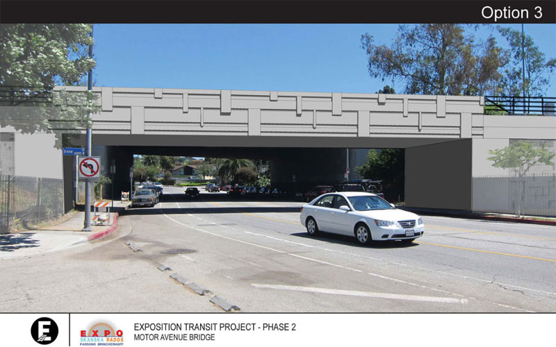 |
|
|
|
Post by Gokhan on Oct 5, 2012 16:13:10 GMT -8
Although Dwight just emailed me a link to these apparently-more-recent plan and profile drawings that only show columns. Nevertheless, these wide columns are far more better aesthetically than a retained-fill section, and they don't block access on the surface. |
|
|
|
Post by Gokhan on Oct 5, 2012 16:17:58 GMT -8
These three Skanska images appeared on Curbed LA yesterday. Perhaps for the Urban Design Committee? Despite being pretentious in trying to mimic an actual arched bridge, my vote goes on Option 1, as the artwork on Options 2 and 3 are highly amateur. Option 1 is also plain and simple, without creating a busy image in its currently serene surroundings, and it's much more likely to be accepted by the public in the long run, while Options 2 and 3 are more likely to be seen as offending design by many who ride under it. |
|
|
|
Post by Alexis Kasperavičius on Oct 5, 2012 16:33:21 GMT -8
|
|
|
|
Post by Gokhan on Oct 5, 2012 16:55:45 GMT -8
Nice pics.
They were also pouring concrete at the Palms Station foundations.
I like the way Skanska/Rados parallel-process the construction, with many things going on at the same time. In contrast, Phase 1 was built segment-by-segment, but Expo Authority was partially blamed at that by coming up with this unusual idea of dividing the construction package into dozens of packages and negotiating it throughout the course of the construction.
Overhead lines are still the biggest risk to the project. Otherwise, most of the construction should be finished by the end of 2014 and the line should open by the end of 2015. Once the construction is finished in late 2014, tuning of the train-control systems and traffic signals during the testing phase will determine when the line can open in 2015. Hopefully some rail cars will arrive by then because currently there are no rail cars at all for Phase 2. No new rail cars = no Expo Phase 2, even if the construction and testing was finished today.
|
|
|
|
Post by Gokhan on Oct 10, 2012 10:41:47 GMT -8
It looks like the only problems right now are the power lines over the to-be-built Venice Boulevard bridge and Colorado Avenue power lines. Venice Boulevard bridge is also being delayed by the Caltrans approvals. Since it's being built by a different contractor, it's also preventing the main contractor from getting into that area to do their work. The issues with the power lines in other locations have been resolved.
The following are the risks to the 2015 revenue date:
(1) Venice Boulevard Caltrans approvals
(2) Venice Boulevard overhead utilities (DWP, SCE, and seven telecommunication companies)
(3) Coordination of work between Balfour Beatty Infrastructure and Skanska/Rados at the Bagley Avenue interface
(4) Colorado Avenue power lines
(5) Acquisition of the Kinki Sharyo light-rail cars
|
|
|
|
Post by darrell on Oct 10, 2012 21:07:56 GMT -8
The median of Olympic Blvd. west of Cloverfield is now lined with k-rails, and the coral trees are surrounded with protective fences:  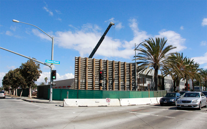 Forms were also standing for the Cloverfield east-side abutment this afternoon. Contrast with rebar up on October 2nd (also a little better photo, Canon T2i vs. iPhone 4S). Rebar was up yesterday for the east-side abutment at Cloverfield: 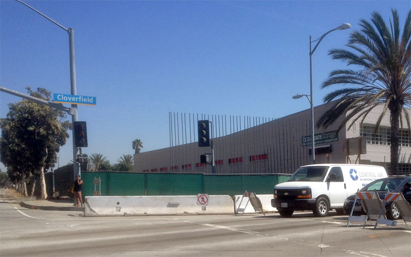 From the Military Ave. crossing... 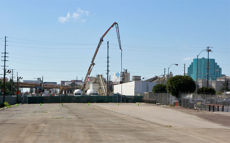 Looking west, concrete was being pumped east of Sepulveda. Also note the temporary parking lot on the Expo right-of-way. 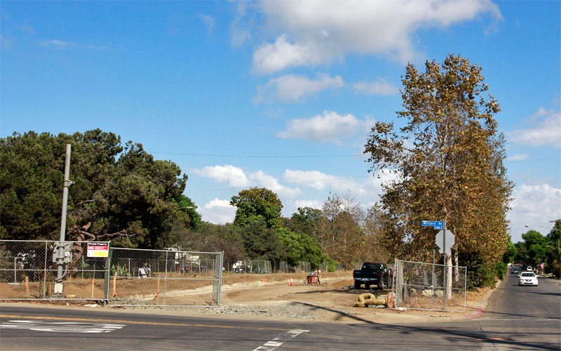 It was a lovely fall day - with leaves turning and puffy clouds - to photograph the new OCS pole bases being poured from Military to Westwood (below). 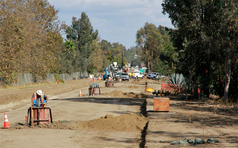 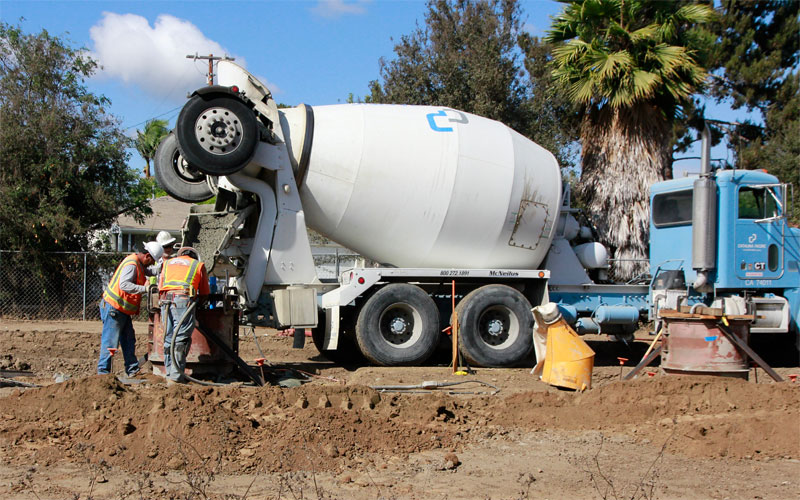 A detail of concrete flowing. |
|
|
|
Post by Alexis Kasperavičius on Oct 12, 2012 18:13:08 GMT -8
|
|
|
|
Post by rajacobs on Oct 15, 2012 19:14:55 GMT -8
This evening I arrived at the Expo Meeting late at Vista del Mar, adjacent to Cheviot Hills, but in time heard some commentary on the Palms station construction. It seems that the tall I-beams and panels that stick up into the air near the intersection for the passenger elevators.
The Expo representative I spoke to explained that the Palms station was technologically challenging because of the tight space in which it's being built. So the current activities include excavating and trenching and the exising hillside (at 45 degress) to a point below where the walls will start that will hold the mech. stabilized earthen fill while at the same time buttressing the existing wall dividing the rail from the freeway and putting in the elevator supports--setting the stage for the supplemental bridge construction. Foundation work for the MSE wall construction will begin at some point after the trenching and wall foundation work is complete.
|
|
|
|
Post by Gokhan on Oct 16, 2012 8:29:50 GMT -8
This evening I arrived at the Expo Meeting late at Vista del Mar, adjacent to Cheviot Hills, but in time heard some commentary on the Palms station construction. It seems that the tall I-beams and panels that stick up into the air near the intersection for the passenger elevators. The Expo representative I spoke to explained that the Palms station was technologically challenging because of the tight space in which it's being built. So the current activities include excavating and trenching and the exising hillside (at 45 degress) to a point below where the walls will start that will hold the mech. stabilized earthen fill while at the same time buttressing the existing wall dividing the rail from the freeway and putting in the elevator supports--setting the stage for the supplemental bridge construction. Foundation work for the MSE wall construction will begin at some point after the trenching and wall foundation work is complete. I think the metal plates and I beams are for shoring. There will be a permanent retaining wall there, similar to the retaining walls at the portals of the USC trench. |
|
|
|
Post by Gokhan on Oct 16, 2012 8:35:28 GMT -8
|
|
|
|
Post by Gokhan on Oct 16, 2012 8:58:01 GMT -8
|
|
|
|
Post by Alexis Kasperavičius on Oct 16, 2012 9:46:01 GMT -8
Nice to see that the "Palms park bridge is to remain" - They really are moving on getting this thing started with a significant number of OCS mounts and bridge abutments already completed with the concrete curing.
Could this be the first ever Metro rail early completion project? Dare we hope they beat the Gold line's on-time record?
|
|
|
|
Post by masonite on Oct 16, 2012 10:19:38 GMT -8
Nice to see that the "Palms park bridge is to remain" - They really are moving on getting this thing started with a significant number of OCS mounts and bridge abutments already completed with the concrete curing. Could this be the first ever Metro rail early completion project? Dare we hope they beat the Gold line's on-time record? Lots of things can go wrong considering they have really barely started construction. Utilities, maintenence yard, rail car deliveries, crossing issues with CPUC, and the lawsuit are just some of the major things that could derail progress. |
|
|
|
Post by Gokhan on Oct 16, 2012 10:50:09 GMT -8
Skanska/Rados's plan is to have the segment between Bagley Ave and 4th St / Colorado Ave opened to revenue service in 2015. No word on when Balfour Beatty Inc can have the segment between Venice Blvd and Bagley Ave opened, which is being delayed by overhead utilities, as they didn't come to the meeting.
|
|
|
|
Post by carter on Oct 16, 2012 21:00:14 GMT -8
I'd be kind of interested to see a map showing the expected speeds of each segment of Phase 2. Obviously, that's partly constrained by CPUC rules and it's up to Metro to decide within that, but I bet would could make some pretty informed guesses....
|
|
|
|
Post by darrell on Oct 16, 2012 23:35:03 GMT -8
I'd be kind of interested to see a map showing the expected speeds of each segment of Phase 2. Obviously, that's partly constrained by CPUC rules and it's up to Metro to decide within that, but I bet would could make some pretty informed guesses.... I expect all the way from Culver City to 17th & Colorado to be maximum 55 mph, except for slowing under I-10 and curving east of Overland. |
|
|
|
Post by Gokhan on Oct 17, 2012 10:55:55 GMT -8
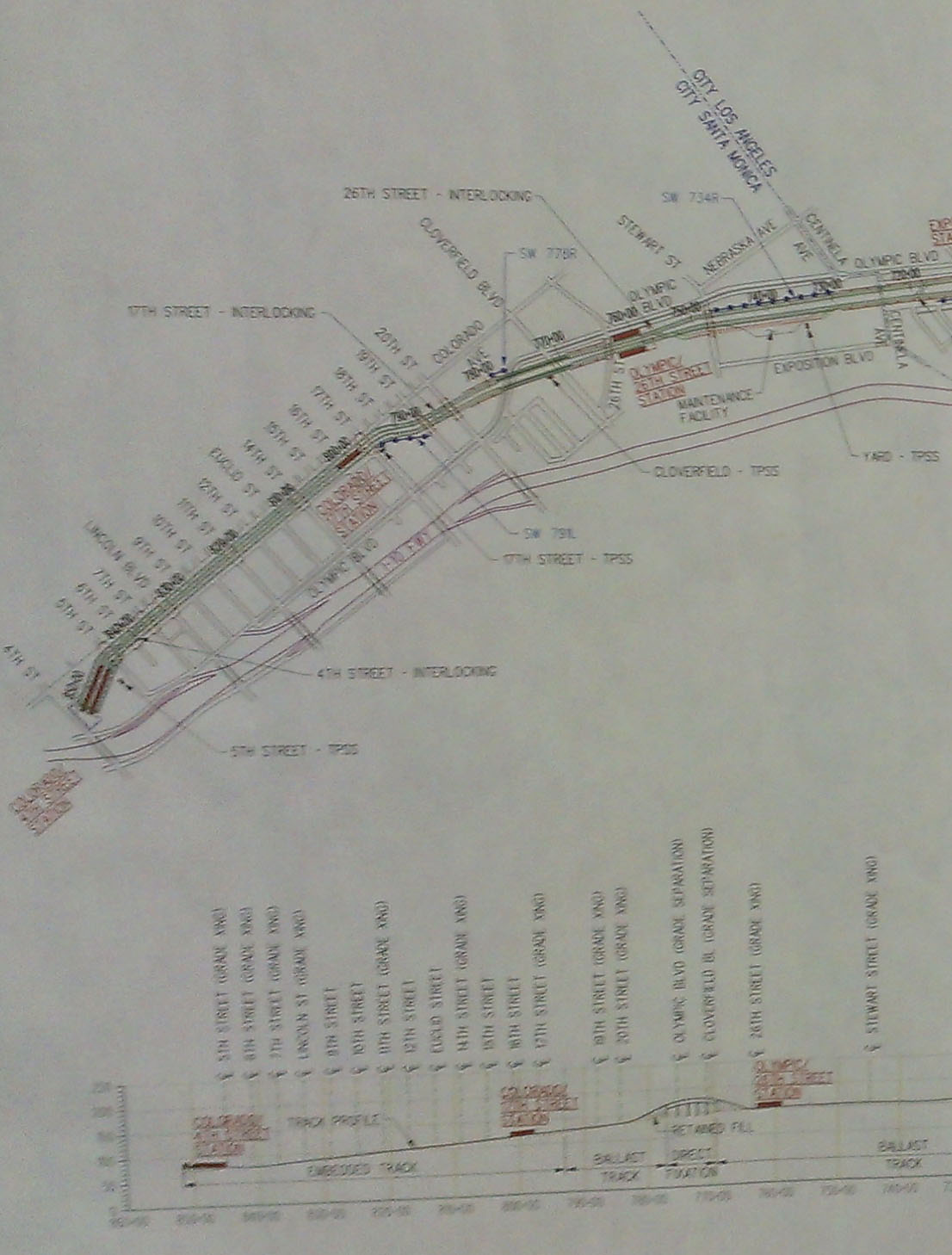
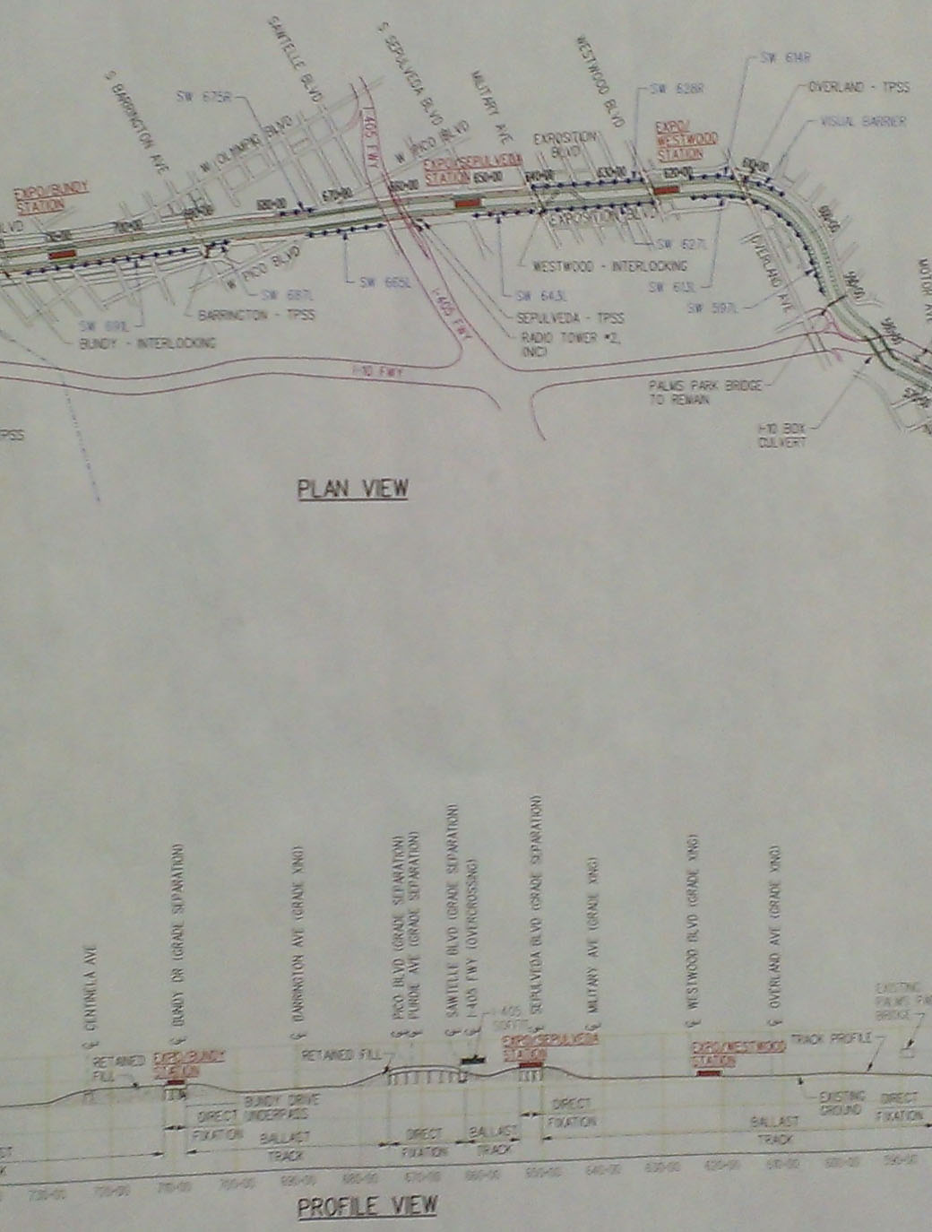
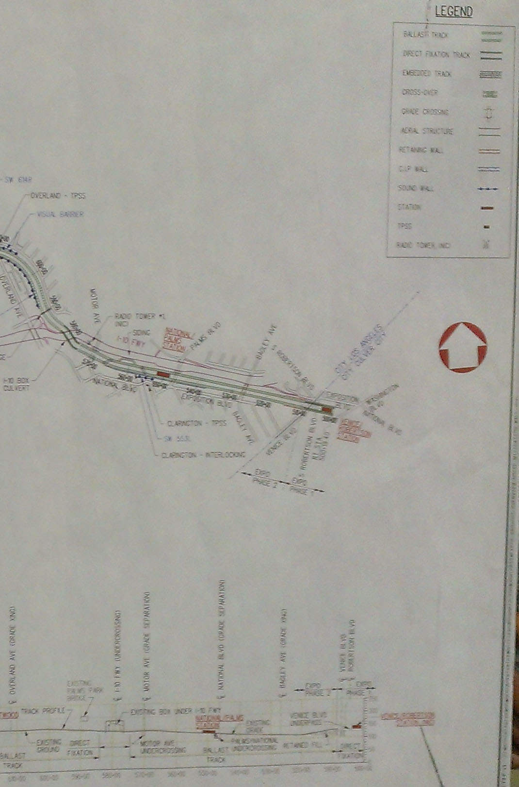
I'd be kind of interested to see a map showing the expected speeds of each segment of Phase 2. Obviously, that's partly constrained by CPUC rules and it's up to Metro to decide within that, but I bet would could make some pretty informed guesses.... I expect all the way from Culver City to 17th & Colorado to be maximum 55 mph, except for slowing under I-10 and curving east of Overland. I just looked at the FEIR drawings and I was surprised to see a lot of speed restrictions: Venice/Robertson to Motor: 55 MPH I-10 box: 25 MPH Trench east of Palms Park: 35 MPH Trench west of Palms Park: 45 MPH Westwood to Sepulveda: 55 MPH Sepulveda to Sawtelle (under I-405): 35 MPH Sawtelle to Gateway: 45 MPH Gateway to Barrington: 55 MPH Barrington to Centinela: 35 MPH Centinela to 26th: 55 MPH 26th to Cloverfield: 35 MPH Cloverfield to 19th: 55 MPH 19th to 18th: 35 MPH 18th to 17th: 25 MPH 17th to 4th: 30 MPH @ 4th: 10 MPH due to track switching The slowest section of Phase 2 will definitely be Colorado with 1-mile-long 30 MPH speed limit, frequent traffic lights, and track switching at the end of line. I expect it to take about 6 - 8 minutes between the 17th St and 4th St stations, unless Santa Monica agrees to give signal preexemption to the trains. |
|
|
|
Post by carter on Oct 17, 2012 16:18:37 GMT -8
I expect all the way from Culver City to 17th & Colorado to be maximum 55 mph, except for slowing under I-10 and curving east of Overland. I just looked at the FEIR drawings and I was surprised to see a lot of speed restrictions: Venice/Robertson to Motor: 55 MPH I-10 box: 25 MPH Trench east of Palms Park: 35 MPH Trench west of Palms Park: 45 MPH Westwood to Sepulveda: 55 MPH Sepulveda to Sawtelle (under I-405): 35 MPH Sawtelle to Gateway: 45 MPH Gateway to Barrington: 55 MPH Barrington to Centinela: 35 MPH Centinela to 26th: 55 MPH 26th to Cloverfield: 35 MPH Cloverfield to 19th: 55 MPH 19th to 18th: 35 MPH 18th to 17th: 25 MPH 17th to 4th: 30 MPH @ 4th: 10 MPH due to track switching The slowest section of Phase 2 will definitely be Colorado with 1-mile-long 30 MPH speed limit, frequent traffic lights, and track switching at the end of line. I expect it to take about 6 - 8 minutes between the 17th St and 4th St stations, unless Santa Monica agrees to give signal preexemption to the trains. Thank you for posting that, Gokhan. Those figures more or less make sense to me. However, I think your estimate on the Colorado stretch is a little bit more dire than it needs to be. 6 to 8 minutes would mean trains traveling on average between 7.5 and 10 mph along that stretch. Even with signals, that seems a bit of a high estimate for travel time, especially considering there are no stops in between 17th and 4th. Google Maps pegs that at 3-4 minutes for a car making that trip, which is basically how the train would be operating in this case. |
|
|
|
Post by Alexis Kasperavičius on Oct 18, 2012 5:43:51 GMT -8
|
|
|
|
Post by Gokhan on Oct 18, 2012 8:35:40 GMT -8
However, I think your estimate on the Colorado stretch is a little bit more dire than it needs to be. 6 to 8 minutes would mean trains traveling on average between 7.5 and 10 mph along that stretch. Even with signals, that seems a bit of a high estimate for travel time, especially considering there are no stops in between 17th and 4th. Google Maps pegs that at 3-4 minutes for a car making that trip, which is basically how the train would be operating in this case. In theory, yes, but in practice, the fully grade-separated 1-mile stretch from La Cienega to Culver City took 7 minutes yesterday and it typically takes 4 or 5 minutes in the westbound direction. Trains can be much slower than buses in the end-of-line stretch because they are trying not to hit the bumpers and going slow through crossovers. They also have to wait for the other train if there is already a train nearing the crossover. On top of that, there are numerous traffic lights in that stretch and some will be red. Speed limit is also only 30 MPH, not 35 MPH. |
|
|
|
Post by carter on Oct 18, 2012 9:04:52 GMT -8
However, I think your estimate on the Colorado stretch is a little bit more dire than it needs to be. 6 to 8 minutes would mean trains traveling on average between 7.5 and 10 mph along that stretch. Even with signals, that seems a bit of a high estimate for travel time, especially considering there are no stops in between 17th and 4th. Google Maps pegs that at 3-4 minutes for a car making that trip, which is basically how the train would be operating in this case. In theory, yes, but in practice, the fully grade-separated 1-mile stretch from La Cienega to Culver City took 7 minutes yesterday and it typically takes 4 or 5 minutes in the westbound direction. Trains can be much slower than buses in the end-of-line stretch because they are trying not to hit the bumpers and going slow through crossovers. They also have to wait for the other train if there is already a train nearing the crossover. On top of that, there are numerous traffic lights in that stretch and some will be red. Speed limit is also only 30 MPH, not 35 MPH. Those are all good points, Gokhan. Hopefully having three tracks at the terminal helps things move faster. |
|
|
|
Post by LAofAnaheim on Oct 18, 2012 9:57:20 GMT -8
Will there be tracks incoming/outgoing of the 4th/Colorado station? In New York, at Cooney Island they had additional tracks so that trains didn't slow to a crawl when incoming to the terminal station. This is the pain when boarding/exiting a terminal station in LA, which sucks because we have a lot of them in short distances (i.e. Union Station, 7th Street/Metro Center, Culver City and Wilshire/Western....besides the outlying stations). I point those out b/c they're interim terminal stations. The only terminal station that is completely set in stone and will not be extended is the Blue Line south of Long Beach, but because the Blue Line is a loop south of 5th street, it doesn't have to slow to a crawl at the end.
So, the next true terminal station will be 4th/Colorado (all other current terminals are interim b/c extensions are possible). So, will there be an extra track to keep speed high or only 2 tracks?
|
|
andop2
Junior Member

Posts: 70
|
Post by andop2 on Oct 18, 2012 10:35:23 GMT -8
So, the next true terminal station will be 4th/Colorado (all other current terminals are interim b/c extensions are possible). So, will there be an extra track to keep speed high or only 2 tracks? I'm not sure why the slope upward on the terminal station at 4th/Colorado, requiring a grand staircase. Could it be that they are leaving open the possibility of an elevated crossing of 4th street and the freeway to head south and eventually tunnel back to Lincoln? Also, I think they need more than the four ticket terminals depicted (could use some additional temporary terminals at Culver City in the meantime as well). |
|
andop2
Junior Member
Posts: 70
|
Post by andop2 on Oct 18, 2012 10:46:32 GMT -8
However, I think your estimate on the Colorado stretch is a little bit more dire than it needs to be. 6 to 8 minutes would mean trains traveling on average between 7.5 and 10 mph along that stretch. Even with signals, that seems a bit of a high estimate for travel time, especially considering there are no stops in between 17th and 4th. Google Maps pegs that at 3-4 minutes for a car making that trip, which is basically how the train would be operating in this case. In theory, yes, but in practice, the fully grade-separated 1-mile stretch from La Cienega to Culver City took 7 minutes yesterday and it typically takes 4 or 5 minutes in the westbound direction. Trains can be much slower than buses in the end-of-line stretch because they are trying not to hit the bumpers and going slow through crossovers. They also have to wait for the other train if there is already a train nearing the crossover. On top of that, there are numerous traffic lights in that stretch and some will be red. Speed limit is also only 30 MPH, not 35 MPH. 6th and 7th Street are not major intersections and complete preemption will work here. 11th Street, 14th Street, and 17th Street are not so major that preemption wouldn't be possible here as well. The only real conflicts are 5th Street (freeway offramp) and Lincoln Blvd. 5th Street shouldn't be a problem for departing trains--they will just wait until the light turns green before they leave the station. And Lincoln Blvd can be managed if left turns are prohibited from Colorado in both directions. People will quickly learn to use Olympic, Broadway, or Santa Monica if they need to make a left turn onto Lincoln. |
|