|
|
Post by metrocenter on Dec 14, 2010 11:38:33 GMT -8
Will there be a new bridge crossing the San Gabriel river? Yes it will be replaced. The Final EIR for the project (2007) would have replaced only the bridge deck. But since that time, it has been determined that the bridge structure does not meet seismic retrofit standards. Thus, the project was updated by the SEIR to include replacement of the bridge. (Reference: SEIR, page 2-2.) |
|
elray
Junior Member

Posts: 84
|
Post by elray on Dec 14, 2010 15:07:26 GMT -8
Having waited nearly 60 years for electric rail service to return to the Monrovia-Duarte area, I can stand a few more months. I presume some of the months will be spent on designing the project to avoid the "Why is there never enough time to do the job right, but alway time to do it over? Thank you. We must remember that done right, these systems will be in place for 100 years or more - but done wrong, will be abandoned. I'd much prefer to wait an extra six months, two years, or a decade, and put up with the gridlock in the interim, to see projects built right, than built quickly - not that we couldn't achieve both, but haste seems to beget bad compromises. |
|
|
|
Post by bobdavis on Dec 14, 2010 16:53:10 GMT -8
One of the "stickier wickets" will be the bridge across Huntington Dr. in Arcadia. I understand it will be designed to closely resemble the present ex-Santa Fe bridge, which may have special status as a "Route 66 landmark." Among other parties involved in the project, we have BNSF and probably the Surface Transportation Board with a place at the discussion table.
|
|
|
|
Post by bobdavis on Dec 15, 2010 21:28:05 GMT -8
Latest report from tonight's GLFE board meeting: Caltrans has signed off on the PSR (Project Study Report). This covers the IFS going over the eastbound I-210, the track going under I-605, and probably the bridge going over the 210 east of Irwindale Ave. "Agreement in principle" has been reached with Metro and BNSF regarding the former Santa Fe track west of the San Gabriel River; this should be finalized next month. Also expected next month is a report on the maintenance facility agreement with Monrovia. By this time next year, I should be able to put on my "Sidewalk Superintendant" hard hat and see construction in progress in my old home town.
|
|
|
|
Post by trackman on Dec 16, 2010 6:19:29 GMT -8
Latest report from tonight's GLFE board meeting: Caltrans has signed off on the PSR (Project Study Report). This covers the IFS going over the eastbound I-210, the track going under I-605, and probably the bridge going over the 210 east of Irwindale Ave. "Agreement in principle" has been reached with Metro and BNSF regarding the former Santa Fe track west of the San Gabriel River; this should be finalized next month. Also expected next month is a report on the maintenance facility agreement with Monrovia. By this time next year, I should be able to put on my "Sidewalk Superintendant" hard hat and see construction in progress in my old home town. Initial year construction efforts should be utility relocations, right? Relocating power poles and electrical lines, improving storm drain inlets, etc. Sexy stuff. I am skeptical that we will see anything substantive with the 210 bridge overpass - Caltrans just now approving a PSR for that? |
|
|
|
Post by rubbertoe on Dec 16, 2010 8:36:29 GMT -8
Initial year construction efforts should be utility relocations, right? Relocating power poles and electrical lines, improving storm drain inlets, etc. Sexy stuff. I am skeptical that we will see anything substantive with the 210 bridge overpass - Caltrans just now approving a PSR for that? If the June/July 2012 Substantial Completion date for the IBS that I referenced earlier from recent GLFE documents is correct, I would imagine there will be some very substantive things going on very soon. You don't build an 800 foot bridge over the 210 freeway in 18 months without doing something substantive  I'll be posting pics as soon as things start rolling. This is up in my neck of the woods. Sounds like Bob Davis lives close by too. RT |
|
|
|
Post by rubbertoe on Dec 16, 2010 9:43:58 GMT -8
|
|
|
|
Post by metrocenter on Dec 16, 2010 10:28:15 GMT -8
Latest report from tonight's GLFE board meeting: Caltrans has signed off on the PSR (Project Study Report). This covers the IFS going over the eastbound I-210, the track going under I-605, and probably the bridge going over the 210 east of Irwindale Ave. "Agreement in principle" has been reached with Metro and BNSF regarding the former Santa Fe track west of the San Gabriel River; this should be finalized next month. Also expected next month is a report on the maintenance facility agreement with Monrovia. By this time next year, I should be able to put on my "Sidewalk Superintendant" hard hat and see construction in progress in my old home town. Initial year construction efforts should be utility relocations, right? Relocating power poles and electrical lines, improving storm drain inlets, etc. Sexy stuff. I am skeptical that we will see anything substantive with the 210 bridge overpass - Caltrans just now approving a PSR for that? The Construction Authority issued a "Notice to Proceed" to Skanska to begin work on the 210 bridge ("Iconic Freeway Structure") back in August. Through the fall and winter, the contractor is getting the remaining permits (including the project study report from Caltrans) as well as finalizing the design. I don't believe there are any utilities involved at the bridge site. And they've been taking soil samples for some time now. So to me its feasible that they will begin bridge construction in early 2011, according to schedule. Since I work in the area, I too will be out taking pictures from time to time during my lunch breaks. That looks so much better. But it's very slow. |
|
|
|
Post by bobdavis on Dec 16, 2010 12:29:05 GMT -8
Utility relocations should not take quite as long as some other projects; first of all, at the risk of sounding a bit cynical, the City of Los Angeles is not involved, and except for Azusa, all the existing electric infrastructure belongs to Southern Calif. Edison. (I'm an Edison retiree) Another part of the project that interests me is the removal of the former Santa Fe track, which will probably occur in the 2nd quarter of 2011; I've already offered to bring a spike puller (a.k.a. a claw bar) to the ceremonial "pulling of the first spike" if such an event is held. Knowing that this railroad abandonment will be followed by construction of an all-new electric railway brightens my day every time I think of it. The lack of physical work at this "stage of the game" reminds me of an observation about a duck: Moving calmly on the surface, but paddling vigorously underneath. And another news item: the GLFE office has expanded in anticipation of increased activity next year. Watch this space!
|
|
K 22
Full Member
Posts: 117
|
Post by K 22 on Dec 16, 2010 14:36:21 GMT -8
I was thinking about this the other day and I was wondering if this would work.
When the downtown connector is finished, the Blue Line is probably coming up this way - so how about having the Blue Line go from Long Beach to Sierra Madre Villa and then have a brand new Foothill Line go from Union Station to Azusa.
Of course this means the Blue Line and the Foothill Line would be running alongside each other from Union to Sierra Madre Villa - so you would probably have them alternate during this stretch if possible - but then a Long Beach-bound Blue Line train would then have to share with the Gold/Expo Line in the downtown stations - which could potentially slow it down.
Just wondering how doable this was if you do break this potentially enormous line apart when the connector shows up.
|
|
|
|
Post by metrocenter on Dec 16, 2010 15:18:55 GMT -8
I was thinking about this the other day and I was wondering if this would work. When the downtown connector is finished, the Blue Line is probably coming up this way - so how about having the Blue Line go from Long Beach to Sierra Madre Villa and then have a brand new Foothill Line go from Union Station to Azusa. I agree the Blue Line will have to be split, due to the imbalance in demand. (I don't think this imbalance is going to change, even after the various Foothill Extensions come online.) My proposal (which originally appeared in the Regional Connector thread) is to have the Blue Line extend from Long Beach to Pasadena, and the Foothill Line extend from Pasadena to Azusa/Montclair/Ontario. The overlap would be in Downtown Pasadena, which is a significant destination and a good place for transfers. This way, the high volume of Blue Line trains wouldn't have to run nearly empty all the way across the San Gabriel Valley. (In the image below, ignore Blue Line B2.) 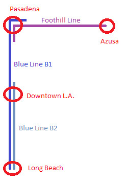 |
|
|
|
Post by bzcat on Dec 16, 2010 16:28:21 GMT -8
Is there layover area in Downtown Pasadena? Your Blue B1 train probably has to terminate at Sierra Madre because of the crossover track. But that might be overly complicated... and also means people from Arcadia or Azusa have to ALWAYS transfer at Pasadena... not ideal.
Why don't we go with a more simple 2 train option instead of your 3 train shuffle?
Have only some of the trains run the full length from Long Beach to Azusa (call it "Gold" line) and the remaining trains run from Long Beach to Union Station (call it "Blue" line). That way, the heavier ridership corridor from Long Beach to Downtown will always have more service. The Blue:Gold service frequency ratio doesn't have to be 1:1. We can adjust it base on time of day demand.
|
|
|
|
Post by bobdavis on Dec 16, 2010 17:16:53 GMT -8
Back in the ancient times, when the world (or at least your writer) was much younger, Pacific Electric ran the Monrovia-Glendora Line from 6th & Main to the outer stations. Every other train went all the way to Glendora, the others turned back at Monrovia. In modern times, a similar situation is seen in Sacramento, where every other train going eastward runs all the way to Folsom, and the others turn back partway out. (and my mental jukebox is cueing up Johnny Cash)
|
|
|
|
Post by jdrcrasher on Dec 16, 2010 22:01:46 GMT -8
For some reason I really don't see the value and benefit in doing that, metrocenter. What benefit really results from cutting this line in two?
|
|
|
|
Post by masonite on Dec 16, 2010 23:36:14 GMT -8
For some reason I really don't see the value and benefit in doing that, metrocenter. What benefit really results from cutting this line in two? It is almost certain that this will be necessary. It is simply too expensive to operate trains over such a long area with few paying customers to offset the costs. The Gold Line already costs almost twice per passenger mile that some of the other lines do, because it just can't seem to attract passengers. This is a cost incurred every day. I think Chinatown would be a good area for a turnaround. Unfortunately, I think the Expo/Eastside line will have to have the same thing done, because those Eastside stations are some of the least used in the entire system. Of course, the Connector could change this some, so maybe it would only need to be done to one out of every two or three cars and some could go the whole way. When I see on the Gold Line Foothill Extension site that from Montclair to Downtown Los Angeles will be around 75 minutes, I find it hard to believe anyone would be interested in doing that trip, especially when one can do the same trip on Metrolink in much less time. |
|
|
|
Post by LAofAnaheim on Dec 17, 2010 17:51:11 GMT -8
Checking out the new Foothill Extension website today (http://foothillextension.org/), I feel there is a ridiculous number of high parking spaces at each station. It's like the GLFE extension is saying "nah, you don't have to walk to our stations, you can drive". What's the point of taking Metro especially when you have very easy access to drive? Are any of these stations going to charge fair market price or is this being subsidized by Metro? A dollar a day would be a nice start to help cover some costs. These lots take up valuable space which could be used with new pedestrian destinations like offices/homes/buildings. It's unfortunate 200+ space parking garages are planned for each station.
|
|
|
|
Post by jdrcrasher on Dec 17, 2010 21:29:47 GMT -8
A good location for a parking garage (maybe 3 stories) is at Citrus College, at the corner of Foothill and Citrus. You could have a ped bridge across Foothill to the station.
This would benefit not just the station but the college as well, as most of the parking spaces there are at full capacity during peak times (which is usually in the morning and midday).
|
|
|
|
Post by LAofAnaheim on Dec 17, 2010 23:03:33 GMT -8
A good location for a parking garage (maybe 3 stories) is at Citrus College, at the corner of Foothill and Citrus. You could have a ped bridge across Foothill to the station. This would benefit not just the station but the college as well, as most of the parking spaces there are at full capacity during peak times (which is usually in the morning and midday). Then what's the point of Metro rail if more parking is made to accomodate already the existing supply? I'm not saying no to more parking, but what's really the incentive to take Metro rail when we keep putting in significantly high abundant supply of parking. Instead of 500 spots, let's go with 300, etc... The college has plenty of parking already. There's buses and a future rail station opening in 3 years. That's plenty... |
|
|
|
Post by matthewb on Dec 17, 2010 23:53:50 GMT -8
I'm totally with you LAofAnaheim, a college right next to a light rail line seems the perfect place for people to take the train to class. No need for a gigantic parking garage. Take that money and spend it on pedestrian improvements between the station and the college so that people feel comfortable and safe walking in the California sunshine. Take the real estate and let them build multi-story apartment buildings so that people can live close to transit. You'd get the same number of riders, but wouldn't need to waste all that money on a parking garage.
|
|
|
|
Post by trackman on Dec 18, 2010 10:19:27 GMT -8
I was thinking about this the other day and I was wondering if this would work. When the downtown connector is finished, the Blue Line is probably coming up this way - so how about having the Blue Line go from Long Beach to Sierra Madre Villa and then have a brand new Foothill Line go from Union Station to Azusa. I agree the Blue Line will have to be split, due to the imbalance in demand. (I don't think this imbalance is going to change, even after the various Foothill Extensions come online.) My proposal (which originally appeared in the Regional Connector thread) is to have the Blue Line extend from Long Beach to Pasadena, and the Foothill Line extend from Pasadena to Azusa/Montclair/Ontario. The overlap would be in Downtown Pasadena, which is a significant destination and a good place for transfers. This way, the high volume of Blue Line trains wouldn't have to run nearly empty all the way across the San Gabriel Valley. (In the image below, ignore Blue Line B2.) That appears complicated. IMO, both the Foothill Extension and the Regional Connector will create more demand, especially with the Connector. After each is open, there just might be compatible commute period demand from the expanded Gold Line as there is comming into downtown on the Blue Line. Whatever the plan might be, the initial plan should be as simple as possible and allow flexibility. |
|
|
|
Post by jdrcrasher on Dec 18, 2010 23:30:14 GMT -8
It is almost certain that this will be necessary. It is simply too expensive to operate trains over such a long area with few paying customers to offset the costs. The Gold Line already costs almost twice per passenger mile that some of the other lines do, because it just can't seem to attract passengers. This is a cost incurred every day. There are many reasons why this is the case: For one, it hasn't reached any potentially HUGE stops, like downtown Azusa, Citrus College, or Ontario Airport (btw, metrolink doesn't stop at the airport - like LAX, you have to take a shuttle to get there). Another thing to remember is that the current "C" function from East LA to Sierra Madre is only temporary. Once the Blue Line is connected to it, the Foothill segment's ridership will likely go up. Same with the East LA segment and the Expo Line. Finally, this is one reason why transit oriented development is so important. We need to increase the ridership GREATLY to help make it at least somewhat viable. Not everyone is gonna take the line from end to end. Depending on that for ridership might not be a good idea. One thing to keep in mind is that a lot of this has to do with the fact that Los Angeles is not a monocentric city like New York. It's polycentric, like Tokyo, but perhaps on an even larger scale. The closest thing to Manhattan that we may have is the area from Downtown to Santa Monica. But even then, we have FAR more "nodes" then New York. Now, we CAN, imo, make Downtown the biggest "node", but it wouldn't dominate the rest of the city on anyway near the same scale as Manhattan. |
|
|
|
Post by matthewb on Dec 19, 2010 9:48:14 GMT -8
Well, Manhattan, from tip to tip is about 13 miles. Downtown LA to 4th and Colorado in Santa Monica is about 16 miles. It's not entirely unfair to group that corridor together when comparing to New York. In that sense you get only a slightly more spread out central business district than New York, though smaller in terms of the total jobs in the area. With a few subway lines, it can be made much more dense than it currently is, without leading to any real decrease in quality of life. I don't predict densification to the point of making a comparison to Manhattan realistic, though, at least not in the next 30-50 years. I do, however, see the potential for a more centralized city, in which positive feedback between interconnected business districts across the westside leads to further development and densification along the corridor.
|
|
|
|
Post by crzwdjk on Dec 19, 2010 11:39:20 GMT -8
I'm sure not many people would want to travel all the way from Long Beach to Azusa or Ontario on light rail, but there will be plenty of trips for shorter segments of the line, and lots of overlap in those trips, so it makes sense to just run trains all the way through if there are no other concerns. Generally, longer lines are broken up when they get unreliable, because each stop adds a potential for delay, and eventually those delays can accumulate and make it hard to keep trains running on time. Of course, you could always add in some extra dwell time at a few stations to let late-running trains make up time.
|
|
|
|
Post by masonite on Dec 19, 2010 13:35:37 GMT -8
It is almost certain that this will be necessary. It is simply too expensive to operate trains over such a long area with few paying customers to offset the costs. The Gold Line already costs almost twice per passenger mile that some of the other lines do, because it just can't seem to attract passengers. This is a cost incurred every day. There are many reasons why this is the case: For one, it hasn't reached any potentially HUGE stops, like downtown Azusa, Citrus College, or Ontario Airport (btw, metrolink doesn't stop at the airport - like LAX, you have to take a shuttle to get there). Another thing to remember is that the current "C" function from East LA to Sierra Madre is only temporary. Once the Blue Line is connected to it, the Foothill segment's ridership will likely go up. Same with the East LA segment and the Expo Line. Finally, this is one reason why transit oriented development is so important. We need to increase the ridership GREATLY to help make it at least somewhat viable. Not everyone is gonna take the line from end to end. Depending on that for ridership might not be a good idea. One thing to keep in mind is that a lot of this has to do with the fact that Los Angeles is not a monocentric city like New York. It's polycentric, like Tokyo, but perhaps on an even larger scale. The closest thing to Manhattan that we may have is the area from Downtown to Santa Monica. But even then, we have FAR more "nodes" then New York. Now, we CAN, imo, make Downtown the biggest "node", but it wouldn't dominate the rest of the city on anyway near the same scale as Manhattan. I agree that not all ridership should go from end to end nor should that be a goal, but with the Gold Line I question how many people are really going to go from places like Azuza to Arcadia if there isn't much around that Arcadia station except a parking lot. I think over time there will be some transit oriented development along the line in those cities, but that will take a lot of time. Right now, how much bus patronage is there from Azuza to Arcadia? There is traffic on the 210, but can people really use the Gold Line to travel faster than using a car? Maybe, if their destination is right next to a station, it might, but if not, then no. People that live in these suburbs have cars and are generally not poor. If they can't use transit to get to their destination faster and there are no parking problems, then why will they use it? Some people like trains and transit like us, certainly will, but that won't fill trains. Not to pick on the Gold Line, I think some of the immediate stations on the Expo Line have that same issue. Are there walkable destinations (i.e. offices) near stations? Is it going to be worth it for people to spend 5-10 minutes making it to the nearest Expo station to go to Culver City when they then have to walk 12-14 minutes from the nearest Expo station to Culver City. Not as much as if Downtown Culver City was right next to the station. Anyway, not every station can be a destination station nor should they be. Some stations are residential in nature and pick up those type of passengers. A great line will have a mix of destination stations and a few residential heavy stations thrown in. I think the problem with the Gold Line is going to be that there are simply too many residential stations and not enough destination stations. Lets hope I am wrong. |
|
|
|
Post by bobdavis on Dec 19, 2010 21:01:47 GMT -8
For many of us in the San Gabriel Valley, Pasadena is our "downtown", and only on special occasions do we go to downtown LA or Hollywood. I know automobiles and parking structures are anathema to many transit enthusiasts, but today's reality means providing parking. It will probably be a different story when gas goes to $10 a gallon, but that hasn't happened yet.
|
|
|
|
Post by masonite on Dec 19, 2010 21:43:46 GMT -8
For many of us in the San Gabriel Valley, Pasadena is our "downtown", and only on special occasions do we go to downtown LA or Hollywood. I know automobiles and parking structures are anathema to many transit enthusiasts, but today's reality means providing parking. It will probably be a different story when gas goes to $10 a gallon, but that hasn't happened yet. I def. think that these Gold Line stations east of Pasadena need parking. Eventually, I think there could be some good development around these stations as well as the local governments seem open to changing some building codes towards that end and these are generally pretty prosperous places, so we won't have developer hesitancy to do so that we have near Green and Blue line stations. My concern is that for now, a lot of these people are really going to have to want to go to Pasadena to get a decent ridership number for the Gold Line. The misnamed Memorial Park Station is actually very handy to Old Town Pasadena. However, the eastern part of Downtown Pasadena, especially along Lake Street is a decent walk from the freeway Gold Line Lake Station since most of the heart of this district is south of Colorado. Well, we will see in about 4 years. |
|
|
|
Post by jdrcrasher on Dec 19, 2010 23:14:24 GMT -8
I agree that not all ridership should go from end to end nor should that be a goal, but with the Gold Line I question how many people are really going to go from places like Azuza to Arcadia if there isn't much around that Arcadia station except a parking lot. I think over time there will be some transit oriented development along the line in those cities, but that will take a lot of time. Well, when it comes to Azusa, building the new Target (which has parking on the bottom and the store on top) was a good start. Now if only the Azusa Village Center (also known as "Block 36") can be built. And I believe there are also plans for another major retail store in the vicinity of the station. I'm not sure where Foothill Transit posts it's ridership numbers, but I can tell you that having ridden on Line 187 so many times, it is a VERY busy corridor, especially during rush hour. |
|
|
|
Post by LAofAnaheim on Dec 20, 2010 8:34:22 GMT -8
^ With that much required parking for a Target, how is any development able to pencil-out profitability wise for developers? Can you even expect construction soon if hundreds of parking spots are required?
|
|
|
|
Post by rubbertoe on Dec 21, 2010 18:31:49 GMT -8
Just received an e-mail update from the authority. Looks like the IFS construction will start in June 2011, here is the relevant paragraph...
This month, the Authority made significant progress on Phase 2A and the IFS. Caltrans approved the Phase 2A (Pasadena to Azusa) Project Study Report/Project Report (PSR/PR) and Type Selection Study, essential documents for the progression of the IFS and overall Phase 2A project. The PSR/PR, a detailed technical document required by Caltrans when working in their right-of-way, was approved for all elements of Phase 2A including construction of the IFS; upgrades to existing bridges, underpasses, and the I-210/I-605 Interchange; conduit laying; fence replacement and other key elements. Caltrans’ “Bridge Type Selection Committee” approved the Authority’s “Type Selection Study” after a substantive meeting in Sacramento with the Authority and the Skanska USA team to discuss the engineering, technical studies, and preliminary design submitted for the IFS. These approvals not only keep the IFS on schedule to begin construction in June, but also keep the entire Phase 2A alignment on schedule as we prepare to select a design-builder in the coming months.
RT
|
|
|
|
Post by rubbertoe on Jan 11, 2011 8:14:16 GMT -8
|
|


