|
|
Post by JerardWright on Sept 25, 2008 16:50:05 GMT -8
 Thursday, October 16th, 12:00 to 1:30 p.m. Los Angeles Central Library 630 W. 5th St. Los Angeles, CA 90071 Tuesday, October 21st, 6:30 to 8:00 p.m. Japanese American National Museum 369 E. 1st St. Los Angeles, CA 90012 For additional information, call 213.922.7277 or visit metro.net/regional connector.
|
|
|
|
Post by JerardWright on Oct 15, 2008 9:51:27 GMT -8
Here's a much improved conceptual image of what the Connector will do. Reminder that the meetings will start this Thursday afternoon at the Central Library. |
|
|
|
Post by whitmanlam on Oct 15, 2008 21:27:05 GMT -8
I couldn't attend the Downtown Connector meeting today. I'll try to make it to the meeting on Tuesday at the Japanese American National Museum.
|
|
|
|
Post by bobdavis on Oct 17, 2008 16:44:46 GMT -8
I was at the meeting yesterday (along with others whose names I've seen on this board). One of the items discussed was "surface or underground?" It seemed clear that the consensus of those present favored underground. I looked at the "grade level" map, and my inner hillbilly said "That dog won't hunt!" To follow the surface streets as shown in the map would require very tight curves, even worse that the Muni "N" line in San Francisco. Also, it just takes one drunk or incompetent driver trying to play "bumper cars" with an LRV to tie up this critical link. This is one case where doing it right the first time should overrule the urge to pinch pennies (even when the pennies add up to 80 to 100 million bucks). The other big concern is where the Connector ties into the Gold Line near 1st and Alameda. One idea is to have Alameda St. routed through an underpass beneath the rail junction, but then how do drivers going eastbound on 1st get onto Alameda? (One suggestion is routing them via local side streets, with, one would hope, plenty of large, clear signs.)
|
|
|
|
Post by kenalpern on Oct 17, 2008 16:52:24 GMT -8
Definitely, this is where long-term vision should override short-term financial considerations.
Is there a $80-100 million difference between alternatives?
I just love the fact that there's only two meetings, one at lunchtime. This is NOT a local project but a regional project, and the outreach to the whole county just isn't being done!!!
|
|
|
|
Post by JerardWright on Oct 17, 2008 17:32:01 GMT -8
... The other big concern is where the Connector ties into the Gold Line near 1st and Alameda. One idea is to have Alameda St. routed through an underpass beneath the rail junction, but then how do drivers going eastbound on 1st get onto Alameda? (One suggestion is routing them via local side streets, with, one would hope, plenty of large, clear signs.) Yep, they could use 2nd and Temple Streets as flexible directional flows from San Pedro to Vignes to meet up with the First Street Bridge and to that some extensions of current streets to meet up with Temple such as Hewitt or Garey or even dare I say it Central Avenue. This way they could close off 1st Street to local traffic and leave that crossing for transit vehicles only ala West Portal in San Francisco. That would be a way to integrate an additional bike lane and street landscaping on First Street and further calm car traffic between East LA and Downtown enhancing the transit and commerical activities between Little Tokyo and Boyle Heights. |
|
|
|
Post by damiengoodmon on Oct 18, 2008 8:07:19 GMT -8
In addition to the limited left turns at the interestion, there are two major flaws with Metro's "underground alternative":
1) It's not all underground - there is still a street level crossing at 1st street, where during rush hour 48-60 trains, 1st street traffic and pedestrians will all intersect at a location where an accident or significant delay would shut down the system.
2) East-west trains (Expo-Eastside Extension) have no stop at Little Tokyo Station. Only trains heading into/out of Union Station would stop at Little Tokyo station.
The "primarily underground" alternative proposed by Metro is in large part predicated on two faulty determinations: a) that the existing Little Tokyo station must be maintained, and b) that Gold Line rail service to the area can't be maintained during construction of an underground WYE.
The appropriate location of the WYE is under the 1st/Alameda intersection, the new Little Tokyo station needs to be at the Southwest corner of 1st/Alameda (shallow underground or trench), and rail service on the Eastside Extension can be maintained during construction of the transitional structures to 1st Street and Alameda Street, via a one-track segment between Temple/Alameda and 1st/Garey.
This will require:
1) a shoe-fly (and possible street widening/parking restriction) on 1st Street
2) a temporary station on the eastside of the eastern track on the northwest corner of 1st/Alameda
3) crossovers north of Temple/Alameda and east of 1st/Garey
|
|
|
|
Post by damiengoodmon on Oct 18, 2008 8:23:54 GMT -8
Draft Memo below. Images being created and likely finalized. MTA’S FLAWED “PRIMARILY UNDERGROUND” ALTERNATIVE
MTA’s Downtown Regional Connector proposed “underground alignment,” actually is only “primarily underground,” because there is an at-grade crossing at 1st/Alameda. If built as currently proposed an accident at the intersection would shut down 4 of the 5 light rail lines on the system and wreak havoc at MTA. The primarily underground alignment currently proposed is predicated on several inaccurate assumptions:
1) Access to Little Tokyo station or the Eastside extension could not be maintained during construction of the Downtown Regional Connector.
2) There is a need to maintain the existing at-grade Little Tokyo station, as opposed to demolishing, rebuilding and relocating the station.
3) The elimination of left-turn movements in all directions at the 1st Street/Alameda intersection would be minimal, and not impact several adjacent already overburdened intersections downtown.
4) There would not be a severe traffic impact to 1st Street east-west traffic with a crossing that will feature 48-60 train crossings per hour during peak hours.
5) The pedestrian safety issue could be mitigated with several tall pedestrian bridges, which no one would ever use if people were allowed to cross the intersection at street-level.
And the most understated aspect of both the proposed at-grade and primarily underground alignments is that ANY FUTURE EAST-WEST LINE (e.g., CULVER CITY TO EAST LA) WOULD BYPASS LITTLE TOKYO COMPLETELY. Only trains heading into/coming out of Union Station would stop at Little Tokyo. Culver City to East LA trains would not be heading into/coming out of Union Station.
THE BETTER ALTERNATIVE: 100% UNDERGROUND (CURRENTLY NOT BEING CONSIDERED BY MTA)
There is no logical explanation for eliminating consideration of demolishing and rebuilding the Little Tokyo station, especially since if the connector is to work, this must occur. The appropriate placement of the relocated Little Tokyo station is at the southwest corner of 1st/Alameda – a property MTA already assumes they will need to purchase for the primarily underground alignment anyway. At that property a shallow underground station (without a mezzanine level) or a shallow trench station can be constructed and the WYE MTA intends to construct, can be done so under 1st/Alameda. This alternative would mitigate all of the above problems:
• Instead of having the Culver City to East LA connection (Expo-Eastside Gold) bypass Little Tokyo, both of the probable connections (Expo-Eastside Gold, and Blue-Pasadena Gold) would stop in Little Tokyo.
• Provide sufficient distance to transition from underground to the at-grade crossings at Temple/Alameda (which heads into Union Station) and 1st/Vignes (which heads into East LA).
• Eliminates the safety issue by eliminating the at-grade 1st/Alameda crossing, and improves pedestrian circulation.
• It doesn’t just allow the 1st/Alameda intersection to maintain current traffic conditions; by eliminating the at-grade turn on the Eastside Extension it actually improves the traffic conditions and MTA rail operations.
Keeping the Gold Line Operating During Construction
Operations on the Gold Line/Eastside Extension can be maintained as the 100% underground option is constructed by single-tracking the Eastside Extension between the at-grade Temple/Alameda and 1st St/Vignes crossings. Gold Line trains, which at best only operate at 3.5-4 minute combined headways during peak hours, would have timed departures from Union Station. This period of single-tracking can be as short as 4-6 months if construction of the ramps is simultaneous and deferred until the end of construction. On 1st Street a one-track shoe-fly would need to be constructed between Vignes and Alameda, requiring temporary widening on the northside of 1st Street or a lane drop/parking restriction. On Alameda, the eastern track (currently the northbound track) would be utilized for the single-track segment. A temporary 10-foot wide Little Tokyo station would be constructed on the eastside of the eastern track on Alameda, to maintain access to Little Tokyo during construction. Temporary crossovers would need to be constructed east of 1st/Vignes and north of Temple/Alameda for transition to the shoe-fly.
Comparative Cost
The 100% underground alternative may have a less disruptive environmental impact during construction and actually be cheaper to construct than the proposed primarily underground option, which requires completely depressing Alameda Street. A potential joint development at the 1st/Alameda southwest corner also becomes more likely and feasible. |
|
|
|
Post by jejozwik on Oct 18, 2008 10:13:41 GMT -8
that TOD at 1st and alameda is what is really messing things up. if that was not in the works i would say that continuing the underground section under 1st/alameda emerging just north east of the current goldline eastside curve. from there have the tracks pull an inverted Y to connect to the north and east running tracks. and by building a little tokyo 2.o station on the north bound inverted y tracks would solve the lack of stop. but like i said, the TOD is getting in the way. how official is that proposal? 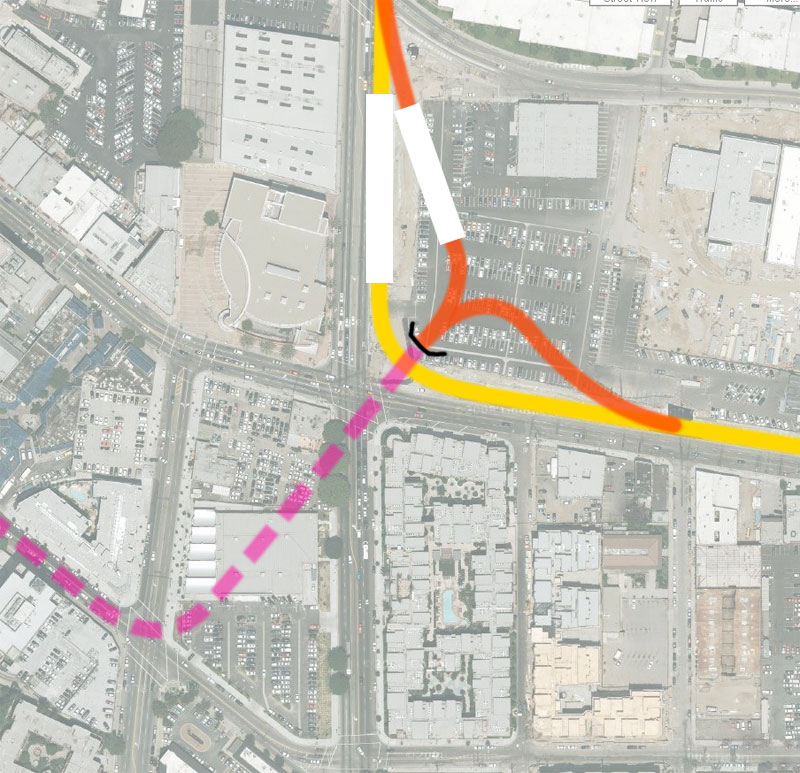 |
|
kenny
New Member

Posts: 12
|
Post by kenny on Oct 18, 2008 11:16:07 GMT -8
To allow a Little Tokyo stop in all directions, how difficult would it to build the station on the Y? Doing that it would become the LRT hub station other the other side of downtown, like 7th/Metro is now.
|
|
|
|
Post by jejozwik on Oct 18, 2008 11:44:37 GMT -8
anyone know the total cost of the little tokyo station? can it be scrapped when the regional connector is built? seems like the central point of this issue is that existing station placement....
|
|
|
|
Post by bluelineshawn on Oct 18, 2008 13:22:20 GMT -8
The new station at Los Angeles street would be only 1 block from Little Tokyo. Two blocks to that pedestrian mall that everyone goes to. Barely any farther than the current Little Tokyo stop. Maybe 100-150 yards more. I don't see the reason for all the concern.
|
|
|
|
Post by darrell on Oct 18, 2008 13:42:48 GMT -8
 Underground at Alameda was considered by Metro last spring ( February presentation, Alternatives 6 and 8), but discarded. The Blue Line currently has 11 peak trains per hour per direction. Double that with Expo and you get 44 total. Let's look at how the surface level of 1st and Alameda would likely operate: The image above shows its proposed configuration, with neither through traffic on Alameda nor left turns from 1st Street crossing the 1st Street median. So there are only two signal phases needed: Green for through traffic on 1st (Red for trains), and Green for trains crossing 1st (Red for traffic). Pedestrians would cross Alameda with the 1st Street traffic phase, and cross 1st Street with the train phase at the crosswalk indicated on the west side of Alameda (unless a pedestrian bridge is built). A standard signal has a cycle every minute, 60 per hour. That's ample for 44 trains per hour, especially since train movements will frequently overlap (eastbound and westbound together on one signal cycle). In fact, by the time the tracks reach 1st Street they've already split into two pairs: one toward Union Station and one turning onto 1st Street, each carrying 22 trains per hour, no more than the current Blue Line. Note that 11 trains/hour/direction is less than downtown Dallas (17), Portland (16), San Francisco (16), Denver (14), and San Diego (12). If the purpose of the Connector if for Long Beach and Santa Monica trains to go to Pasadena and East L.A., there may not be movements from Union Station to East L.A. In that case any train movements could overlap except East L.A. toward downtown with downtown toward Union Station. This doesn't really matter. They all will stop at the Little Tokyo subway station, and passengers could step off there and onto the next train toward Union Station if needed. |
|
|
|
Post by JerardWright on Oct 18, 2008 14:05:35 GMT -8
The new station at Los Angeles street would be only 1 block from Little Tokyo. Two blocks to that pedestrian mall that everyone goes to. Barely any farther than the current Little Tokyo stop. Maybe 100-150 yards more. I don't see the reason for all the concern. Very true, however during the presentation, Dolores (The lead Project manager) stated that they need the EIR to further refine where they place the station in the Historic Core to Little Tokyo area. So the 1st/Alameda crossing, and the Broadway to Los Angeles Street station location will be the key pieces for Metro requiring detailed analysis for the EIR. * Because if the station is closer to Little Tokyo, the extra platform at 1st/Alameda won't be needed because the subway station around Los Angeles or San Pedro Street will take care of it. * If it's moved closer to Broadway then the extra platform will be needed and could be mitigated by closing off 1st to thru traffic, shifting that traffic one block away to Temple and 2nd Street. The extra lane that is gained will be used to build the side platforms for East LA branch ridership and the elevated pedestrian bridge becomes a floating mezzanine to the whole Little Tokyo station. In fact because of the design of the Alexan Savoy complex opens more towards 2nd Street this could be done. But further refining will be needed which is why they need an EIR. (Whew) This a very good cliffhanger to sell to the Metro Board to get this approved for further refinement with an EIR. Because of a it's importance and how it all comes together for the LRT system. |
|
|
|
Post by kenalpern on Oct 18, 2008 15:44:22 GMT -8
I'm very confused, but I'm very annoyed that this isn't being done entirely underground. Corners appear to be on their way to being cut that will give Metro nightmares with the PUC.
I again decry the absolute lack of outreach (only two meetings, and only one in the evening, and nothing outside of the Downtown area).
Santa Monicans, Culver City and Mid-City L.A. residents, Eastsiders , Long Beach residents and Pasadenans ALL have a stake in this Connector.
I'd like a letter from TTC, perhaps protesting this lack of outreach. As far as I'm concerned, this is the next key effort (along with Crenshaw/Green/LAX) that Metro is doing after Expo, and I want more regions included in its planning.
In short, I want the whole damn thing underground so as not to screw up traffic. I know that they're trying to cut costs to make this favorable with the FTA, but you can be sure that the PUC will not let this happen!
|
|
|
|
Post by damiengoodmon on Oct 18, 2008 17:16:07 GMT -8
Jeremy,
If you're going to rebuild the Little Tokyo station, why not place it in a location where it allows both probable lines (Expo-Eastside and Pasadena-Blue) to serve the area, AND preserve the TOD development opportunities on the northeast 1st/Alameda corner.
I asked the project manager, why the totally underground alignment (that did not have a station near 1st/Alameda) was discarded and he said the Little Tokyo community wanted the station. The Little Tokyo community apparently was not satisfied with the 2nd St station, which as Jerard pointed out, may end up being as far east as Broadway. It was made clear in the presentation that the exact location of that 2nd/Los Angeles station is not set in stone.
Oh Darrell, bless your heart:
1) Train movements at the location are very likely to take a lot longer than 60 seconds
2) The number is 48 trains an hour (under which these systems are anticipated to operate)
3) It would be irresponsible to not design the system to handle 60 trains per hour in the future, if not more, given that 4 minute headways have been in the planning discussion for the Blue Line for over 5 years now. If they were in the planning discussion in 2003, imagine what the situation will look like in 2033. (I just don't know why the fact that these are 100 year projects is so lost on some folk.)
State what you just wrote in this forum to Melvin Clark ("a cycle every minute, 60 per hour...s ample for 44 trains per hour") and explain to him those 44 trains include the Eastside Extension, Expo and Blue Line and then see how loud he laughs. Why the "at-grade at whatever cost" advocates continue to ignore the loud concerns of the operations folk who find these type of situations (sections of at-grade track shared by more than one line) horrific is beyond me.
Three of the four lines using the connector (Eastside Extension, Expo and Blue) have significant street-running segments that jeopardize on-time performance as it is.
Additionally, east-west train movements at 1st/Alameda (Eastside to Expo and vice versa) prohibit any movements other than east-west train movements. And north-south train movements at 1st/Alameda (Pasadena to Blue and vice versa) prohibit any movements other than north-south train movements. To say nothing of currently not probable, but depending on system expansion could be likely, west-north and south-east movements.
Even just with north-south and east-west movements, only in Sim City could this intersection be choreographed so perfectly 40, 44 or 48 times an hour, 5-8 hours out of every day for the next 100 years.
In the real world these light rail systems have to operate in an environment with that, which most call "people." (Again, why this concept is so difficult for some to understand is beyond me.) "People" like:
-The operators who are slightly behind schedule because they had to pee
-The patrons who hold the doors for their friends to make the trains
-The elderly/disabled who take a little bit longer to cross the street or board the train
-The cyclists who think they can fit their bikes on one part of the train and have to instead move it to the next car because of crowding
-The motorists who come too far out into the intersection and have to backup to make way for the train; etc., etc., etc.
And speaking of the people who this system must interact with, leaving almost the entire light rail system so vulnerable to TOTAL SHUT DOWN from not just one massive accident, but from one possible fender-bender, is a level of incompetence that should cost someone their job.
Like I said I'm going to be very interested in seeing LADOT's letter, and Metro Operation's memos. There are a lot of foreseeable adverse traffic impacts at no less than 10 intersections, and it will inhibit the TOD opportunities at the site. And I can see operations just having fits about any proposed at-grade crossing on the DTC.
And finally, regarding the safety issue, when the woman from the Little Tokyo Community Council, who was concerned about pedestrian safety asked if anything like this existed anywhere else at-grade, I had to restrain myself from yelling out "There's no where on Metro's system and probably not the country."
The whole point of the connector is to eliminate transfers and provide future flexibility among our transit network. Why we'd spend a billion on something that is so restricted is beyond me.
Kenny,
Don't know if that's possible. I can't currently envision a one-platform station that allows West-north/south-east movements (current Gold Line with the Eastside Extension) AND east-west/west-east AND north-south/south-north movements.
They seem to be in two different locations, requiring two different platforms. Where those platforms are placed is another issue.
I'm thinking one platform under the property under the property on the southwest corner of 1st/Alameda for north-south/south-north and east-west/west-east movements; and another platform under 1st Street for west-north/south-east movements.
|
|
|
|
Post by damiengoodmon on Oct 18, 2008 18:12:30 GMT -8
My suggestion: 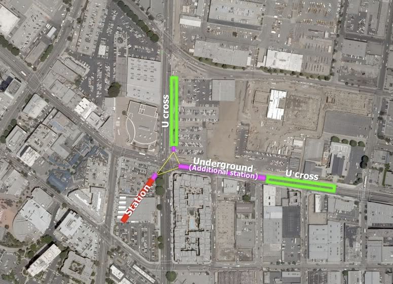 |
|
|
|
Post by spokker on Oct 18, 2008 19:21:18 GMT -8
Oh my God. They are really considering building it like that? That is insane. The connector needs to be underground, Jesus. |
|
|
|
Post by darrell on Oct 18, 2008 21:29:46 GMT -8
A 3-car Blue Line train on straight track clears an intersection from a standing start in about 15 seconds. This video shows under 30 seconds after the Washington station to the median of Washington on that sharp curve, tighter than 1st & Alameda. I should time the curve at Flower & Washington. Updated 10/26/08: It took about 30 seconds for a southbound Blue Line train from a standing start on Flower to complete the curve and clear Washington. Logically 1st & Alameda is the same as Flower & Washington with Expo, only without cars on Flower. Washington = 1st, Flower = Alameda. Same number of trains per hour on each branch. So 1st & Alameda creates no greater constraint than already exists. Ken, the PUC is fine with Flower & Washington, and 1st & Alameda is simpler. Either is fine to plan for, and, as I noted above, if Washington & Flower works at a train frequency then 1st & Alameda will too. Trains will expect to potentially queue ahead of the intersection to adjust for arrival time, waiting for their green signal. Nothing unusual for light rail. No, as I noted before, downtown -> Eastside can coincide with Eastside -> downtown or Union Station -> downtown, and Union Station -> downtown can coincide with downtown -> Eastside or downtown -> Union Station. Only Eastside -> downtown is incompatible with downtown -> Union Station. I don't know if 60-second or 90-second signal cycles would be more efficient. I'd suspect because only two phases are needed and trains can clear the interection in under 30 seconds that 60 seconds would reduce wait time. Ideally give an approaching train some signal priority so it stops less of the time.  Reposting this from March 20, this map shows how Blue Line and Expo (aqua) trains on 2-minute headways would be 2-3 blocks apart on Flower. |
|
|
|
Post by darrell on Oct 18, 2008 23:10:39 GMT -8
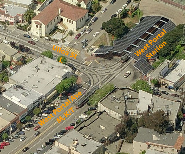 This aerial view of San Francisco Muni's West Portal station shows it has quite a bit in common with 1st & Alameda. Two Muni light rail routes converge here before entering Twin Peaks Tunnel toward downtown San Francisco: Upper left is the L-Taraval. Lower left is M-Ocean View and K/T-Ingleside (the latter diverge farther west). Peak inbound on L is 8 trains 8:00-9:00 a.m. M and K/T are 7 each, for a total of 22 trains per hour per direction, through an at-grade junction. It works fine and has for years. On the subject of capacity of a two-track tunnel, the trunk of the Muni Metro subway under Market Street carries 37* peak inbound trains per hour (8:00-9:00 a.m. at Van Ness station; *32 unique schedule times). So yes, 60 trains per hour (both directions) in the Regional Connector tunnel on two tracks has precedent. |
|
|
|
Post by Gokhan on Oct 19, 2008 0:38:21 GMT -8
Oh my God. They are really considering building it like that? That is insane. The connector needs to be underground, Jesus. It's obvious that this huge at-grade rail junction that crosses 1st St will potentially ruin the operation of all light-rail lines. Since they don't want to make any changes to the Eastside Line as soon as it opens, here is my suggestion: Why not elevate 1st St vehicle lanes over the tracks? Since Alameda is already depressed below the tracks, this will eliminate all grade crossings. Another solution is to depress 1st St below the tracks as well; although, this will require an underground signalized intersection for the vehicles. In fact, this way, a vehicle-free pedestrian zone will have been created around the station. |
|
|
|
Post by damiengoodmon on Oct 19, 2008 3:04:08 GMT -8
Darrell: I say this with as much respect for you as I can, but the more you type the more clueless you expose yourself as being to the operational difficulties of Metro light rail TODAY. Seriously man, put down the at-grade Kool-aid, step away from the table, and pick up a book, put in a public records request, or talk to someone at Metro operations.  Here are excerpts from just one of the what I like to call "HAIR ON FIRE MEMOS" from Metro regarding the shared Flower Street operation from none other than Steve Polechronis to Steven Brye in 2003: Light rail operations have been simulated with the Expo Line operating at a five-minute headway and the Blue Line operating at both a five-minute headway and a four-minute headway. As simulated with both lines operating on a five-minute headway, the delays experienced by Blue Line trains operating during the PM peak period at the Flower and Washington intersection range from zero to 80 seconds with an average of around 30 seconds.
Under the current operating conditions, as observed empirically, Blue Line trains are extremely challenged to hold schedules and maintain consistent five-minute headways during peak operations. It is not uncommon for pairs of trains to be observed entering the Metro Center Station at headways as short as 90 seconds. [NOTE: Again, dealing with the real world - not Sim City. No where in Metro's Blue Line schedule is a 90 sec. headway stated. But the REAL WORLD with street-running segments there are times when frequency is a high as 90 seconds.]
In the event that the first train in a pair of trains operating at a 90 second headway were held at the Flower and Washington intersection, the second train would be unable to advance to the platform of the Grand Station for over a minute and a half. In fact, due to the train length of approximately 270 feet, the second train would be forced to wait as far back as the Main Street intersection before proceeding. This occurrence has the potential to impact Blue Line operations along the entire portion of street running.
This scenario becomes more likely with the advent of four-minute headways operating on the Blue Line while the Expo Line maintains five-minute headways. The combination of a four-minute headway with a five-minute headway will ensure that even under the best conditions, trains will be delayed by an intersection meet approximately every 20-minutes.
On the Expo Line, with both lines operating a five-minute headway, delays experienced at the intersection are much worse than those of the Blue Line. The delays range from zero to 191 seconds with an average of 51 seconds. While traffic signal delays in street running may be routinely as long a 60 seconds, a delay of over three minutes is considered extremely long. This worst-case delay is generated when a northbound Blue Line train holds the signal and is met by a Southbound Blue Line train just after clearing the intersection. This is an occurrence that becomes more likely in the advent of four-minute headways on the Blue Line. The memo ends with a recommendation to: -SUSPEND CONSIDERATION OF THE SHARED FLOWER STREET PORTION, and suggest if it is to continue that there be further exploration of basically rebuilding 7th St/Metro, a half-grade separation at Washington for Expo (neither of which occurred). -Search for an ALTERNATIVE ALIGNMENT down Figueroa. Here's just two realities in the real world vs. Sim City: 1) A 3-car Eastside-Expo heading west would have to wait until the 3-car Blue Line heading north completely cleared the crossing to even enter the intersection. And to fit it in the 60 second window, both trains would have to be at or near the intersection ready to proceed. 2) Southbound Blue-Pasadena could not clear the intersection in the same cycle as westbound Expo-Eastside, because the trains would be heading to the same track and same single westbound platform at the 2nd St/Los Angeles station. Even if the two trains cleared in the same cycle, a minimum 40 second train delay would be imposed on the 2nd train as it waited for the 1st train to slow down, board and clear the 2nd/Los Angeles platform. I could go on and on about real world scenarios, but frankly until you put down the Kool-aid and commit to at least recognizing your addiction I'm not going to help bring you through recovery.  How rich that you've picked an example from one of the worst performing light rail systems in the country. What an absolutely great model for our lovely all important regional connector, eh? FYI Darrell, train bunching in the Market St tunnel was one of the examples people were using during scoping when IMPLORING Metro to build this right. And by now everyone should be suspicious of your use of pictures with absolutely no context to suggest analogous operations on light rail lines. All people have to do is google "West Portal" and "accident" and the results are not settling.One blog involves a car driving into the tunnel and states: "Muni Comes to a Halt After West Portal Tunnel Assault"Another of the articles begins with: "Sigh...it looks like we’ve had Yet Another Accident at the West Portal Station.'The combined three incidences mentioned in just those two articles/blog all occurred over just a 6 month span. That's not "working fine." And from a blog posted in April of last year: West Portal is another "accident waiting to happen" site. A single patrol officer could be kept busy all day tagging the scofflaws that endanger the public with illegal U-turns on that busy street.Don't distort "is fine" with "considers grade separation impracticable." PUC is not fine with Flower/Washington. It only considered the cost of grade separating the crossing impracticable, which is a legal definition that includes among other flaws cost as a consideration - frequently the overriding consideration. PUC staff took the stand and said quite clearly it always believes grade separation is the optimal solution, but it was the Commission (the 5 member appointed board) that felt otherwise. I believe you were there that day so lets stick to the facts. Put down the Kool-aid Darrell and accept 100% underground as the greater power that can restore sanity: 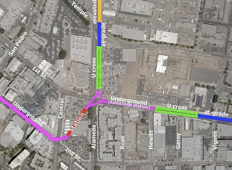 RE: The depressing 1st St alternative. 1) In general, it is more expensive to depress and elevate the street than it is to depress/elevate tracks. 2) Depressing 1st Street only creates more traffic nightmares, because it limits access to 1st St as well. For example Central and Rose and possibly Hewitt would not have access to the 1st St underpass, pushing more traffic onto 2nd and to the 1st/Vignes intersection, because 2nd does not have a bridge over the River. (Restricting access to Hewitt would really land-lock the TOD development on the 1st/Alameda northeast corner). Incidentally, 1st St is the only bride over the river between Cesar Chavez and 4th. |
|
|
|
Post by jejozwik on Oct 19, 2008 7:45:57 GMT -8
Since they don't want to make any changes to the Eastside Line as soon as it opens, here is my suggestion: Why not elevate 1st St vehicle lanes over the tracks? Since Alameda is already depressed below the tracks, this will eliminate all grade crossings. elevating 1st street would most likely raise alot of hub bub from the shops and residences around the area. Another solution is to depress 1st St below the tracks as well; although, this will require an underground signalized intersection for the vehicles. In fact, this way, a vehicle-free pedestrian zone will have been created around the station. i do however like the idea of depressing 1st street as well. it would indeed hide the cars and create a more walkable little tokyo. the new TOD wont hurt things ither Two Muni light rail routes converge here before entering Twin Peaks Tunnel toward downtown San Francisco: Upper left is the L-Taraval. Lower left is M-Ocean View and K/T-Ingleside (the latter diverge farther west). Peak inbound on L is 8 trains 8:00-9:00 a.m. M and K/T are 7 each, for a total of 22 trains per hour per direction, through an at-grade junction. It works fine and has for years. sure it has a precedent, and so do underground or elevated lines. but to put every light rail line [save green] converging at one at-grade, mildly confusing, intersection does seem to be a bit on the low end of the spectrum. also your precedent is not equal in scope. your muni line seems to be in a fairly suburban region, serving a lines that are at most 3.75 miles long. hardly the ridership of half los angeles county. not to mention that single intersection being a main artery off-ramp only a block away for a heavily used highway. and being a bottleneck river crossing. and being within the cbd... do you, in all honesty think that an at-grade solution for this horribly important project is acceptable? or are you just afraid to question what metro has provided? |
|
|
|
Post by spokker on Oct 19, 2008 8:35:33 GMT -8
I have no problem with Expo being at-grade, but this is Downtown we are talking about here, not a single line running through an intersection.
The whole point of the connector is to increase efficiency of our rail network, not turn it into even more of a giant mess. That option IS the definition of a clusterf--k if I ever saw one.
I believe the at-grade option here is indefensible for the reasons already posted by others. It should be thrown out immediately. This is definitely a case where if it can't be grade-separated it shouldn't be built at all.
|
|
|
|
Post by damiengoodmon on Oct 19, 2008 9:51:08 GMT -8
Oh yea Darrell, I forgot to point out that your calculation ignores north-south pedestrian movements at the intersection.
Standard walk time is 3-4 feet per second meaning a cycle time of at least 25-33 seconds would be required.
There's not enough time in the cycle for all the movements unless substantial train delay and/or gridlock is permitted, particularly on 1st St, but also at nearby intersections.
|
|
|
|
Post by darrell on Oct 19, 2008 12:08:13 GMT -8
I will ask Steve Brye what happened between your 2003 memo excerpt and when the Final EIS/EIR was released with this design in 2005. Yes, I also cited cases for train movements that cannot coincide. But notice how these issues are about managing the track junction, not about whether traffic is crossing at-grade between trains passing. Note also the streets at West Portal have many more traffic movements possible than are proposed on 1st Street. Ever heard of someone driving down the Blue Line portal ramp on Flower Street? No, I wasn't there for that portion, and would want to see the whole transcript, especially in light of your side's continuing mis-citation of City of San Mateo. The facts are that except for the Trade Tech driveways, since resolved, CPUC staff did not challenge any Expo Line phase 1 crossings. I heard at an earlier meeting that the new neighbors on Alameda at 1st like the idea of depressing the truck traffic. You spared yourself being wrong. |
|
|
|
Post by darrell on Oct 19, 2008 12:16:40 GMT -8
North-south pedestrian movements across 1st Street are presumably in the crosswalk visible on the west side of Alameda. It doesn't cross any tracks, and would coincide with parallel train movements.
"All the movements"? There are only two: (1) east-west traffic and pedestrians; (2) trains and north-south pedestrians. As previously discussed, some but not all train movements can coincide.
|
|
|
|
Post by kenalpern on Oct 19, 2008 22:02:26 GMT -8
Either First Street needs to be rerouted, or this needs to be underground. Inasmuch as I believe that the street-running portion of the Blue Line will need to be (at least in part) grade-separated SOMEDAY, I think we need to figure out how to avoid another slow-moving portion of the line.
I hope the community weighs in, even if it's just to make sure that the LADOT and Metro are working in tandem on this. I'm cool with this being at-grade ONLY if First Street traffic is rerouted so that lots and lots and lots of trains can move freely through this potential at-grade intersection.
|
|
|
|
Post by Gokhan on Oct 20, 2008 16:09:34 GMT -8
This is really alarming and it needs to be fixed immediately before they attempt to plan more on this ridiculous configuration that makes absolutely no sense.Solution to the underlying problem: Thinking more about this, the segment of the Eastside Line near 1st and Alameda could be taken below ground without interrupting the service. They will need to build a temporary station and a temporary spur, but that's all that is needed. See the image below. Solution to the main problem: I think we really need to push hard to have this segment of the Eastside Line taken below ground. The leaders of the Transit Coalition -- Bart, Ken, and Jerard -- can help us achieve this. What we need to do is to get this option included in the Draft Environmental Study, which will have the Conceptual Engineering in it. This is probably cheaper and much, much more efficient than taking Alameda below ground as proposed. At the end the line will be faster and therefore the project will be more cost-effective, increasing the chances for funding by FTA. Currently the project is being ranked Medium, same as Expo Phase 2, which is surprising since this project is supposed to be the Mother of all Cost-Effective Projects. 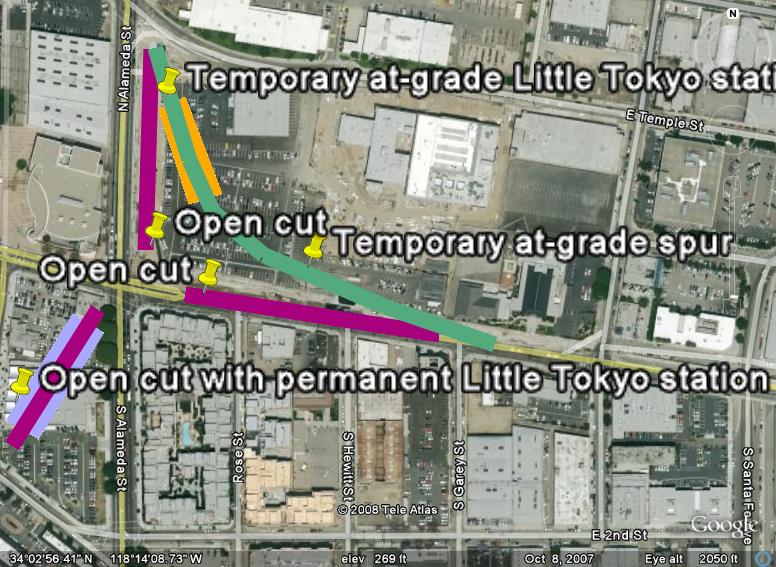 Let's also not forget that one of the factors that killed Pacific Electric was the fact that the lines in Downtown were mostly at-grade and the Downtown congestion eventually required getting rid of the lines there. So, let's learn from the history and not repeat the same mistake.
|
|
|
|
Post by Jason Saunders on Oct 20, 2008 17:40:31 GMT -8
 This image is from the same article as the grey scale one in previous post. In it is a little easier to see the proposed grade separations. Having not been to the meetings I am not sure exactly what is being proposed however from this rendering it would appear the proposal is for three to four layers of seperation: Alameda, First, Rail and Pedestrian. I am not an engineer but it seems to me separating the rail alone by subway would be less expensive then separating four levels by trench and bridge. Here is the article. There are links to two more articles. |
|


