|
|
Post by damiengoodmon on Oct 8, 2007 15:33:05 GMT -8
Downtown-to-LAX, like "Subway to the sea" is a great slogan, but when it comes down to it, there are alternatives that are simply better.
As long as the FlyAway can deliver people directly to their terminal, using HOV lanes almost the entire way, any alternative rail route will have difficulty competing and showing ridership that justifies the investment. And it will definitely beat the train if at least one transfer and 35 mph and/or mixed-flow street-running is required. If (and yes, it will likely not happen any time soon if ever) the Harbor Transitway is ever completed north, rail will never be able to compete.
And I think there's just too much political momentum building around the Wilshire extension to not think that by 2015, Purple line won't at least be under construction to La Cienega (possibly avoiding Beverly Hills altogether with a northern diversion to Cedars/Bevery Center). We have the TBMs just sitting there waiting to be used, and the entire region focused on it.
And I don't disagree that the South Bay Galleria and LAX are ridership generators. I do disagree that the longer travel time and dead zone between LAX and South Bay Galleria, makes it in anyway better or more competitive for federal funding.
Also, while the ROW seems like the path of least resistance, utilities will still need to be relocated, as we're finding with Expo. There's also a required tricky grade separation at Centinela/Florence, another required at La Brea, and maybe another at I-405.
The Prairie alignment is directly adjacent to a cemetery from the ROW to Manchester and then on completely undeveloped land from Manchester to Century. Would there be many utilities to relocate?
And about the only way to avoid extensive utility relocation is with bored tunnel.
I'd rather see the money held and focus remain on the corridor, and in the interim see the implementation of peak-hour bus-only lanes in some portions...but even that's probably a waste of money.
The previous study, I forget which, showed busway showed little travel time reduction in comparison to LRT. Same with mixed-flow LRT.
|
|
|
|
Post by kenalpern on Oct 9, 2007 11:25:44 GMT -8
Hi, Damien et al:
If I understand right, the lion's share of the utility relocation (and there will always, as you've pointed out, Damien, be some utility relocation) for Expo is Downtown where either the ROW's been paved over or the line goes off the ROW. Expand that to all of Crenshaw and it gets very cost- and technically-prohibitive...not undoable, but certainly more challenging.
We're in agreement that the Busway idea is a bad one! Do this right, or don't do it at all. Unfortunately, what I've learned over the years is that we can never, never, never presume anything (good or bad) will happen in the future.
Governmental policy also works this way, so that to start building or even planning a line that goes to Wilshire must presume we know the routing and specs of the Wilshire Subway. Do we? No. Will we? Certainly...but when will that occur?
Hence my suspicion that, in as much as I very much (adamantly) want that Purple Line connection, we might have to include that as a future "Crenshaw Phase Two". Perhaps including this Expo to Purple Line connection as a portion of the first, westward phase of the Wilshire Subway is a more practical way to ensure that this occurs in a timely and organized fashion.
A similar issue occurs with respect to the Green Line/Crenshaw Line connection at Century/Aviation. Operationally, it will be much easier to tie them together there, what with current LAX reconfiguration occurring and LAWA money to be tossed into the mix, then with a Hawthorne or Crenshaw Line south of the ROW that would probably have good ridership but might be more speculative than with utilizing the ROW.
It's all about building a network and not creating new lines that don't reliably connect with the others. By the way, do you know that LAX is considered the tenth-highest employment center in the region? Did you know that Inglewood's City Plan includes utilization of the Harbor Subdivision ROW with a station in "Downtown Inglewood"?
No one (certainly not myself) knows where this will all end up, but it will, ultimately, be the politicians and Metro planners who make the final decision, and not any of us.
|
|
|
|
Post by damiengoodmon on Oct 10, 2007 5:31:07 GMT -8
Crenshaw is a wide boulevard. I'm not sure the placement of current utilities, but we will surely find out. Tunneling could occur any where on the wide street and avoid most of them, except at the station locations. Indeed that is the major benefit of tunneling. And understand, I'm not saying don't serve Downtown Inglewood. In my first post in this thread I stated I was on the fence re the Prairie-Century-Hawthorne route and the La Brea-Hawthorne route, but lean towards the former. I'm just not in favor of using the ROW west of La Brea. The ridership and potential is south; the competitiveness, I believe, especially in light of the new New Starts criteria is not to LAX, but on the La Brea/Hawthorne corridor. Simply, a transfer will be forced unless the Crenshaw Line becomes the people mover and goes into LAX, and I don't see anyone making that suggestion (and if they did I'd question the justification given the low 42 ridership and a competing regional trip time vs. the FlyAway.) So the question is, where will that transfer to the LAX circulator be?: a) Century/Aviation to a people mover (via Crenshaw ROW route) b) Hawthorne/I-105 to a Green line that becomes the people mover (via the Prairie-Century-Hawthorne or La Brea-Hawthorne route) c) Prairie/Florence or Crenshaw/ROW (via a Harbor Sub route that becomes the people mover) I return to my initial suggestion: build the southern route, and through the EIR, get clearance to extend the Green Line. And as part of the LAX renovation, build the Century/Aviation station and LAX connector keeping the Harbor Sub route in mind. Additionally, if the Green Line is extended as the people mover, LAWA would be forced to pay ALL (or at least half) of the extension cost. The Green Line could operate as the people mover for a few years, and turn the service from Sepulveda/Aviation into the LAX over to a Harbor Sub line, when that comes online. At that point the Green Line can break off up Lincoln. I just think that is a better master plan for LAX-South Bay transit. Also, the question is not to serve or not to serve Downtown Inglewood, the question is how and when, and what brings that struggling city maximum benefit. And I'm thinking in 25-year terms, not 5 or 10. (that's the benefit of youth  ) The long-term vision has the ROW served by a route coming from the east to LAX. I support that, and lean towards LRT, due to the high density and the absence of any east-west rail line through the dense/transit-dependent South LA areas between Expo and the Century Fwy (a distance of 70-80 blocks). So why have two lines duplicate service on the ROW, neglecting the existing need and potential development of a southern route (Prairie-Hawthorne or La Brea-Hawthorne), especially when the ROW route makes the project less competitive for federal funding? The many possibilities of multiple hotels and Howard Hughes Promenade type development with thousands of dwellings have all been floated for the Forum and Hollywood Park sites. That's money for Inglewood schools and cops and revitalization that I just don't think the ROW can offer. Regarding Wilshire. When (not if) the Wilshire subway is extended there will be a station at Wilshire/La Brea. Whether the Crenshaw Line will operate that station alone for 2 years or 20 years, it's better to plan for it, than to plan without it. |
|
|
|
Post by JerardWright on Oct 10, 2007 6:46:58 GMT -8
I didn't take a future South Bay extension into consideration due to the way the track interchange at Aviation was designed; any trains coming in from the northern spur would have to join the Norwalk-bound tracks due to the location of the switch. Actually from the design of the wye at Aviation, routing service to the South Bay is quite possible. Maybe I'm wrong.  |
|
|
|
Post by JerardWright on Oct 10, 2007 7:04:32 GMT -8
Also, while the ROW seems like the path of least resistance, utilities will still need to be relocated, as we're finding with Expo. There's also a required tricky grade separation at Centinela/Florence, another required at La Brea, and maybe another at I-405. True, but it's easier to relocate the utilities and build the aerial grade separations on an existing unused railroad. For the Centinela/Florence area all that maybe required is to remove the existing at-grade track and bore the column structure for the elevated all while preserving the trees/bushes along the right of way next to the park and utilize precast elevated concrete guideways that can be fabricated in a staging area next to the right of way in the zoned industrial. La Brea will require the acqusition of properties simply because it will be a station built. The grade separation over the 405 since it's zoned industrial can be a straight forward steel beam and concrete deck bridge with added cosmetic cues to make it visually attractive Yes, but there lies the next point that though boring a tunnel will mitigate this problem, the ridership and existing density doesn't justify it, unless the developer and the City of Inglewood comes up with a very dense zoned master plan for those sites that can counter the costs of the tunneling or in some cases the developer can build the grade separated right-of-way, probably a trench cause it's cheaper to dig that land and re-use it as fill on another part of the site as a park or playground, until then...save boring tunnels for areas with the existing density already in place such as Vermont, Santa Monica/Sunset. |
|
|
|
Post by JerardWright on Oct 10, 2007 7:53:42 GMT -8
And understand, I'm not saying don't serve Downtown Inglewood. In my first post in this thread I stated I was on the fence re the Prairie-Century-Hawthorne route and the La Brea-Hawthorne route, but lean towards the former. I'm just not in favor of using the ROW west of La Brea. The ridership and potential is south; the competitiveness, I believe, especially in light of the new New Starts criteria is not to LAX, but on the La Brea/Hawthorne corridor. The long-term vision has the ROW served by a route coming from the east to LAX... So why have two lines duplicate service on the ROW, neglecting the existing need and potential development of a southern route (Prairie-Hawthorne or La Brea-Hawthorne), especially when the ROW route makes the project less competitive for federal funding? The many possibilities of multiple hotels and Howard Hughes Promenade type development with thousands of dwellings have all been floated for the Forum and Hollywood Park sites. That's money for Inglewood schools and cops and revitalization that I just don't think the ROW can offer. Personally, I see the exact opposite because of it's proximity to LAX, Inglewood and the ROW as a transit conduit as greater potential for that style Howard Hughes/Promenade development. In addition the existing layout of Downtown Inglewood/Market Street is already set up as a town center promenade all it needs is a good anchor to support it. Transit in the form of this connection is one of those anchors. As for the Airport and Downtown Connection, I don't see this line as serving that purpose. I see it more as a conduit for the region and residents within it to access the Crenshaw/Leimert Park/Inglewood areas. In addition the duplication of lines serving a defined concentrated area and then spreading out to serve a greater region is the reason why this would have a great chance of getting new starts funding because it has a greater bang for the $$$. That might be the reason why the Downtown Connector was LACMTA's most effective project and if it went up for Federal New starts money against a Wilshire Subway, the Wilshire subway would not even get a consideration until after the Connector was built. Again this isn't an either or the other in fact getting the right-of-way built up quickly provides the opportunity to create an Inglewood/Hawthorne/Airport Loop within those areas. The right-of-way corridor gets built first then the Prairie/Hawthorne segment next. And with all of these large parcels of land that is being mentioned who says that it all has to be built underground, why not have a parkway with an elevated guideway or the denser housing anchored along the guideway and the lower height/density townhomes built farther out. One further thing that would certainly help the right of way portion, where are the LRV's coming from? Will a new maintenance facility have to be built on the land that is slated for housing? Will this and can this eat up a 1/4 chunk of the large area slated for this new town/village center because there's no cost effective way to get the trains from the route onto the mainteneance facilities. The right-of way will provide a direct connection to those facilities at the same cost that would take to build one wye from the Green Line freeway tracks onto the Prairie/Hawthorne segment. |
|
|
|
Post by damiengoodmon on Oct 10, 2007 12:09:46 GMT -8
Downtown Inglewood/Market Street doesn't offer the globs of land and single ownership, like the Forum and Hollywood Park. Acquisition and purchase of the Downtown Inglewood properties would involve negotiation with dozens of land owners, a coordinated implementation plan, and destruction of properties directly adjacent to residential areas with not a lot of room to maneuver. Not saying it's not possible, just that it is comparatively a much more difficult to do, and likely more difficult to sell to the feds, than building on currently undeveloped land that measures one mile by one-half mile. This is Downtown Inglewood: 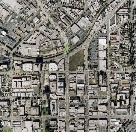 This is the Hollywood Park/Forum area, and the track will be taken out: 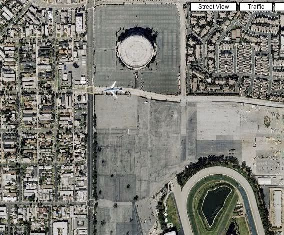 The open land at Hollywood Park is so vast it doesn't even fit in the box. In the previous studies, the density assumed from the projects was so great, some suggested 3 stops were suggested the 1 mile length from Manchester/Prairie to Century/Prairie. And is there any reason to believe the City of Inglewood would not (or has not) adopt the type of zoning necessary to make the Hollywood Park upgrade profitable and attractive for a transit station? The site is frequently mentioned in the press, and I assumed to this point, within the council as the location for that type of high density zoning and commercial and hotel center to attract LAX patrons. Hollywood Park wasn't bought for $260M just for the land owners to sit on it. This is what they did with another racing track they purchased: link. They're going to want to build, and build a lot. And the entire Inglewood revitalization efforts, which have proven difficult on Market Street, would be greatly aided by their success. $2 to 4 billion in development (at the Forum and Hollywood Park) in just one city, directly adjacent to existing transit dependent population, coupled with the annual tax returns from a major commercial/entertainment/hotel center is far more persuasive. Additionally, with two trains on that corridor, it would grade separation a logical requirement at each of the crossings, as opposed to possibly just three, losing all savings in construction cost compared to the southern diversion. It wouldn't be wise to make the same mistake we have on Expo between Washington and the Flower Street tunnel. I agree. I just see it occurring the other way around. And I think it's easier to get political support, fed dollars, and revitalize the Inglewood economy by going Prairie-Hawthorne first. I see this as Phase 1: -Prairie/Hawthorne with Green Line extension into the airport. 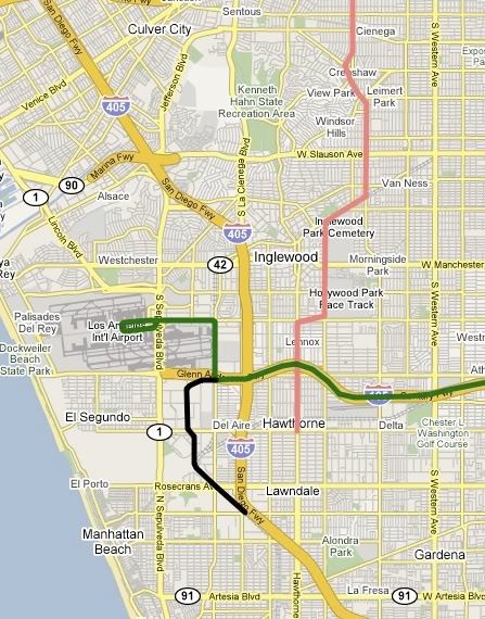 Phase 2: -Harbor Sub taking over the people mover with Green Line to Playa Vista and Hawthorne line extension to the South Bay Galleria. 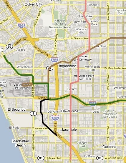 And past studies had (through tunneling) alignments considered servicing both Downtown Inglewood and the Hollywood Park/Forum area. So maybe you can get both with this alignment. as part of phase 1: 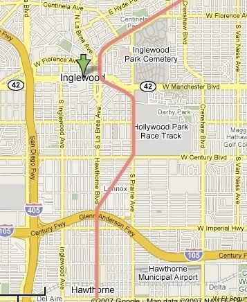 |
|
|
|
Post by JerardWright on Oct 10, 2007 13:26:07 GMT -8
I read the study included a stop at Hollywood Park and Casino. Now I pose a hypothetical question now that facility is removed would a stop still be needed?
Three words. Super Wal-Mart
If that is the case why doesn't the line turn west down Century Blvd right into LAX? From what I remember the problems were trying to squeeze a big box retailer (notice the increase along Century Blvd) chain in an area that had all of the small businesses pissed because of the direct competition. Now a hotel/conference center right off a line serving the airport would help the businesses and be a major factor into the revitalization as a business village.
As for the routing of through service into the airport, that is entirely possible and can be suggested (and is suggested by TTC on the Green Line to LAX powerpoint that we've presented to officials) by specifying that the People Mover trains/guideways are built to the same standards as our LRV's so that trains can potentially run through the airport. JFK Airtrain did that so that in the future the Subway or LIRR trains could go directly into the JFK terminals and on to the City with that simple specification.
|
|
|
|
Post by kenalpern on Oct 11, 2007 5:18:59 GMT -8
Damien, I think that you and Jerard/myself have similar goals, but different ways of approaching them. I don't want to give away too much of what the Green Line Interagency Task Force has been discussing, but:
1) Your approach of including Hawthorne Blvd. (or some adjacent north/south corridor) sooner, and not later, creates a situation where there are too many wyes and not enough loops, and the Green and Crenshaw Lines remain two lines instead of one long one
2) Every concept to date of having regional rail lines go into the airport loop prove too costly and operationally-difficult; at this point, it appears that airport-related commuters will need to be separated from regional commuters (i.e., those who will go by/through LAX, but not to LAX) via a People Mover/MetroRail interface at Century/Aviation
On another note, Damien, I have heard some local/Metro planners suggest that the Forum and Racetrack are not the big destinations that once they were--your information may be different than mine, but that's one of the main reasons that the Harbor Subdivision ROW has been discussed--much more than the Hawthorne, Prairie or La Brea approaches you describe--over the past few years.
Hence my recommendation that the Crenshaw and Harbor Subdivision Major Investment Studies be more linked to each other as an appropriate long-term strategy for South L.A., LAX linkage and the South Bay:
1) Create a Green Line/Crenshaw Line/LAX People Mover hub at Century/Aviation that opens the door for both MetroRail, Metrolink and Metrolink-compatible DMU service on the Harbor Subdivision ROW
2) Establish a future "Crenshaw/South Bay MetroRail project that creates a loop via the South Bay Galleria extension that proceeds to Hawthorne and turns back north to "Downtown Inglewood", and I strongly recommend that TTC meets with that city's planners some time soon
3) LAWA money can legally only go towards the creation of rail that directly acceses LAX--a Crenshaw route that links to LAX via the Harbor Subdivision ROW might enjoy LAWA funds for a Century/Aviation Crenshaw station, but won't get a penny for a route that misses it altogether (such as Hawthorne/Prairie)
|
|
|
|
Post by JerardWright on Oct 11, 2007 8:26:20 GMT -8
"I presented the Get LA Moving Plan to the SCAG planners a couple of weeks ago. One of the questions was, why despite a (conservatively speaking 33%) reduction in tunneling cost why Metro wasn't more heavily considering single-bored twin-track tunneling. It was the only question I couldn't answer."
It's the same reason why in DC the Silver Line in Tysons wasn't considered for a single bore tunnel in it's plans. Bureaucracy. If LA were to build Single Bore tunnels we would have to pay for it ourselves.
|
|
|
|
Post by Tony Fernandez on Oct 11, 2007 8:55:50 GMT -8
What's the problem with the single bore tunnel and why would it not get funding?
|
|
|
|
Post by antonio on Oct 11, 2007 22:28:30 GMT -8
I second that. Even though there is bureacracy, I can't imagine the feds with all their debt not looking for a way to cut costs. If everything Damien tells us is true then single-bore tunneling is very cost-effective. The answer to Tony's question may be that it doesn't get funding because its too logical. Low cost=less money feds have to give out but of course the feds never do ANYTHING logical
|
|
|
|
Post by JerardWright on Oct 12, 2007 5:07:50 GMT -8
Actually, there are no problems with it, the Feds may use the excuse of safety and problems if one tunnel gets damaged via fire or a train derails and crashes into the wall.
That can be alleviated with a simple design of a 2' concrete wall between the two tracks inside the single bore tunnel for damage/fire control and to help operators not get blinded by other trains headlights whizzing by at 55mph inside the dimly lit tunnel.
Also through many designs of newer subway systems they've gone with the two smaller tubes, one for each track. My guess is that there maybe more soil/spoli removed with the single bore but we may use less concrete/rebar overall inside the tube, that figure would have to be figured out because that is a factor in the costs of construction.
|
|
|
|
Post by damiengoodmon on Oct 12, 2007 13:43:46 GMT -8
Without repeating what has already been said, let me address the new comments. As I've alluded to in previous post in the thread, the number of stations needed there is hard to figure, since it would have a lot to do with what the City and landowners come up with. But to be clear, the goal of the prairie route is NOT to serve those two venues (Hollywood Park and the Forum). It is to serve the massive development that would and could occur there, and I don't see how any person or modeler or the feds can ignore that. Just think comparatively to the recently announced NBC studio move to Universal City station, and NoHo redevelopment. Below is the size of those two properties from the same elevation: NBC Studios at Universal City station: 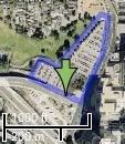 NoHo Art Wave NoHo Art Wave at North Hollywood station: 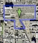 Now, here's the size of the land at Hollywood Park/The Forum from the same elevation: 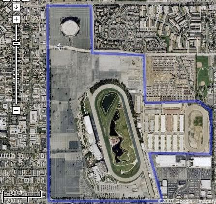 NoHo Art Wave is a billion dollar venture. The NBC studios move is a multi-billion dollar venture. It's just not logical to think that the land isn't poised for a multi-multi-billion dollar development that will be a cash cow for the city of Inglewood, and tremendously contribute to the ridership and thereby competitiveness of the Crenshaw Line. Which was rejected by Inglewood voters, due to the anti-Wal-Mart sentiment. And remember, that was just for the Forum lot. Between Hollywood Park and the Forum there's enough land to fit a half-dozen to dozen Super Wal-Marts and their parking lots. Even in keeping the race track, there's still multiples more land to develop than the combined land used for the NoHo and Universal City station ventures. Should be studied. But keep in mind, all studies I've seen - and I'm reviewing them all again now - have shown more ridership with the line going down Hawthorne than into the airport, due to the residential density and transit dependent ridership and favorable land use. Those numbers must have only increased since then. For example, immediately north of El Segundo Blvd is the old Hawthorne Mall, which is partially or completely owned by the County, and sits almost completely vacant (they want to develop it). Too many wyes? You have one regardless: Crenshaw/Expo. The second is at Imperial/Aviation with a Green Line connection (or possibly - and I know it wouldn't be cheap - at I-105/Hawthorne). I'm saying build the second one, at Imperial/Aviation, just AFTER the Prairie-Hawthorne alignment comes online, as part of the Harbor Subdivision project. The difference is Crenshaw is in the constrained plan and HAS a realistic funding plan through various dedicated revenue sources, that don't include LAWA funds. The Green Line extension is NOT in the constrained plan, an EIR is necessary and it has no funding plan. What I've proposed is to study the Green Line extension through the Crenshaw EIR and building the Green Line extension as the people mover. It allows the extension to pass environmental clearance AND forces LAWA to pay for it. It would seem that would be an easier route to go towards getting the extension built in the near-term. That is not the reason. It was all politics, not engineering. Dragados (the single-bored tunneling Spanish contractors) didn't get into the game until after the Virginia's governors office was bought off...I mean, the decision was made to go elevated with Bechtel. I'm not saying the wall is a bad idea, but I think the argument that the feds would reject single-bore twin-track tunneling for those reasons are stretches. Feds reject any cut-and-cover proposals lately on the basis of glare or derailment? I don't know, but I seriously doubt it. And why would they readily approve box tunnels that have no concrete wall separation and not bored tunnel? Additionally, we are going to be studying large bored twin-track tunneling with the Wilshire Line extension. And again, I've always said trenches are possible in a lot of locations and my goal is to get the trench-cut-and-cover combo seriously studied. The conservative estimate is a 33-40% reduction in cost. The reduction is even greater when economies of scale is taken into account and open-cut stations are built in place of cut-and-cover stations. It's only a matter of time before we wise up to the facts understood in Europe and Asia: it's cheaper, faster and easier to tunnel. I just want this realization to happen sooner rather than later, so we can produce some good lines. |
|
|
|
Post by JerardWright on Oct 12, 2007 15:04:46 GMT -8
Should be studied. But keep in mind, all studies I've seen - and I'm reviewing them all again now - have shown more ridership with the line going down Hawthorne than into the airport, due to the residential density and transit dependent ridership and favorable land use. Those numbers must have only increased since then. Based on the 2003 MIS, there is close to 14,000 more riders on the LAX segment (38,500) than Prairie (24,500), that is because the job density -which wasn't shown on the map- along the right of way is greater around the airport and Inglewood Civic Center. Build the second one? That one at Aviation/Imperial already has the provision for it, where's the provisions at Hawthorne/105? Where are these vehicles are going to be maintained and stored? For the cost of building a wye at Hawthorne/105 we might as well build the LAX section of this project and still have some money left. Hey, I have a great idea! We could use that large Hollywood Park parcel and take up about 1/4 of that lot for this purpose and thus cause the surrounding zoning to change dramatically where the investment wouldn't be as large or robust as it could because we can't wait another 3 years to build a place to store and do maintenance on trains.So based off that logic of waiting until the Prairie portion becomes online to build it almost makes the argument for the Harbor Sub portion first, then tying that into Prairie next, which could have a wye built in at Prairie/R-O-W. I don't quite follow. Which section of the Green Line? Is this the Lincoln/Sepulveda extension? From Century/Aviation to Lincoln/Sepulveda than yes you're right that could work, but that sounds like it is dependent on the Harbor-sub segment being built first. The reason why I'm asking is the logic behind it and the reasons aren't congruent. What in the world is Bureaucracy? Maybe I've got to talk to my old profs who use politics and bureaucracy as interchangable pieces. The main reason over looked was fire protection and in case the train crash into the tunnel walls. In case of a fire smoke will rise to top of the tunnel and in the case of a single bore delay not just one direction but both directions. I said as merely a guess and "logic" as they would try to use to justify not doing anything that would actually make sense. Where is this value from? Is it material or labor? Does that include all of the "safety" precautions such as fire sprinklers and believe it or not HVAC inside the tunnels? I would like for that to happen very soon too, it just needs enough of those questions answered and even a locally built project to suggest that this works and is the way to go so that the feds use it as a model. Maybe we can build the Downtown Connector in this fashion as a test study in this efficency. It's small enough (1.5 miles) that it wouldn't break the bank but also tests the limits of this in a dense environment to simulate how this could work for Wilshire or Vermont corridors. |
|
|
|
Post by damiengoodmon on Oct 12, 2007 16:03:05 GMT -8
The 24K was the result of the median-street running that would have drastically increased trip time.
From the MIS:
Utilization of the former railroad right-of-way offers a unique opportunity for LRT service in the Crenshaw-Prairie Corridor by allowing 63 percent of the proposed Crenshaw/Metro Green Line Alignment Alternative to operate in a dedicated right-of-way minimizing traffic and parking impacts, while providing higher travel speeds for LRT patrons. Approximately 17 percent of the Crenshaw/Hawthorne Alignment Alternative would operate on the former railroad right-of-way.
From ROW/Prairie to Hawthorne/I-105 the Prairie-Hawthorne trains would have been going 35mph while from ROW/Prairie to LAX the ROW-LAX trains would have been going 55mph. Of course its going to show higher ridership under those conditions. It's an apples to oranges comparison.
Every study that has evaluated grade separated to airport compared to grade separated into Hawthorne has shown the Hawthorne route produces more daily ridership, even without including Forum or Hollywood Park events, even without including massive development on the lots.
The '94 study put 2010 projections in the high 30s. I have to think that the same studies out to 2035 would be in the high 40s/low 50s. With development at Holly Park/Forum in the high 50s at least. With a La Brea/Wilshire Purple line connection, you're looking at a line at least in the high 70s.
Green Line operating as the people mover. When the Harbor Sub comes online it takes over the people mover duties, with the Green Line branches off at Sepulveda to continue up Lincoln. Phase 1 and phase 2 maps are in the thread somewhere.
|
|
|
|
Post by JerardWright on Oct 13, 2007 6:27:15 GMT -8
It's not actually apples and oranges, it's more the difference between Granny Smith's and Fujis, How many stops are in that stretch of Prairie? It's not the usual a stop every mile it looks like every 2-3 stops a mile, so even with Grade separation we're looking at 35mph because the trains can't accelerate to 55 mph and decelerate to 55 mph like a car would. So tops you'd shave a minute from the running time because the section that really needs that grade separation is through Centinela Hospital. So despite all those activity centers and density along the line, the route will only move 25,000 riders, 14,000 less than the Aviation/LAX alignment.
The type of development opportunities are greater for Downtown Inglewood because it would directly serve the Airport area and the transit corridor becomes a development magnet for business marketing. That caters to middle to upper class clientle with nice sit-down resturants while being very close to LAX and the City.
Let's look at the site conditions shall we. An existing Green Line, an existing below grade freeway that climbs in elevation to a above grade freeway at Inglewood Avenue, R1.5 zoned next to freeway, a definite transfer station.
First what configuration would you have this line in?
Now if this were an elevated it would require more concrete to build the elevated flyovers and thicker and deeper columns on the depressed freeway section. This would also require more right-of-way space from the freeway in order to make room for one or two of these flyovers. In addition since a transfer station will be located there, this adds a considerable amount of complexity because now we have to find a reasonable location to allow transfers to occur while allowing the wye/flyover to be tied in.
More than likely this could be a single bore tunnel. This would require deeper tunnelling to go under the freeway and the switch from single bore to double bore for safe crossing between the freeway right of way and tunnel. In addition this would still require freeway widening and re-striping of lanes to allow the portal to be built so that the underground flyover comes to the freeway right of way. Double that if we're building two underground flyovers one at each end of Hawthorne station. Now you may ask, where are all the costs and headaches coming from? The answer, the widening of the freeway which will require reconfiguration of the on-off ramps because at that location, it begins it's transition for drivers to merge onto the 405 and LAX airport area and now we're dealing with Caltrans. In addition the elevation of the freeway changes from below grade to above grade again for the transition with the LAX and 405 freeway so below grade configuration would require a steep incline to meet with the Green Line right-of-way or more land to open up to a portal.
In addition the grade separations at the right-of-way segments can be done with precast elevated guideways between Centinela and La Brea to prevent a possible roller coaster or even a pour in place concrete away from the freeway at Aviation/Imperial with land, caissons and configuration already mapped out and provided on the existing guideway for a future provision which would add $15-30 M a piece, I'll add $30 million more for the La Brea and Century Stations, $50M for the LAX trench so we're talking about $140 M for grade separations -most of which can be paid for by other sources- to that 2.5 miles of at-grade railroad portions of which are already grade separated via cul-de-sac with $60M/mile , That's $290 M. The cost of the flyover in whatever configuration, the freeway widening and cases reconfiguration of lanes, especially the carpool lanes and the transfer station which is a big factor add the costs will start at $275M.
|
|
|
|
Post by damiengoodmon on Oct 14, 2007 8:18:01 GMT -8
I don't see it anywhere near as complicated, and maybe it's because you see the station as east of the existing platform, whereas I see it as west. 1) From my observation, at about 20-30 feet between the current tracks, the ROW is wide enough for a wye to be constructed without needing to alter the freeway lanes. But lets take worst case scenario and say the 20-30 feet isn't enough, still there's plenty of space for re-stripping the lines without requiring any property takes or major reconfigurations. 2) With the station just below the freeway floor, the wye wouldn't be steep, it would actually be much more shallow than the Rosa Parks wye. 3) The portal would be on the Metro property directly northwest of Freeway/I-105. 4) With a single-bored tunnel the station can be built in the tunnel, not requiring a box-cut station. The box-cut method would only be necessary to construct the pedestrian transfer to the Green Line platform and wye. And there only needs to be one wye, not two, as the wye is for connectivity not service. Excavating the box would simply take one long weekend (Friday night to early Monday morning, and constructing and paving the SHALLOW incline within the Green Line ROW could occur during off peak hours. Here's the overview, with the aqua box being the station portal, the yellow the box-cut for the wye and pedestrian transfer: 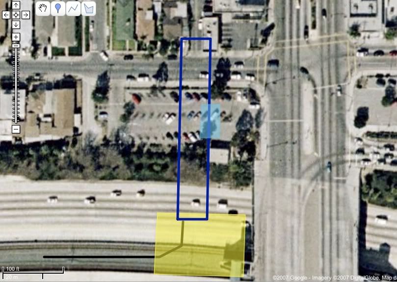 There is a dramatic incline at Centinela/Florence, where an elevated property would be directly adjacent to the commercial properties south of the ROW and tower the residential properties north of it. And you didn't tack on the cost of the wye and elevated grade separation at Imperial/Aviation. And does the Century bridge need widening? |
|
|
|
Post by JerardWright on Oct 14, 2007 9:29:04 GMT -8
I don't see it anywhere near as complicated, and maybe it's because you see the station as east of the existing platform, whereas I see it as west. 1) From my observation, at about 20-30 feet between the current tracks, the ROW is wide enough for a wye to be constructed without needing to alter the freeway lanes. But lets take worst case scenario and say the 20-30 feet isn't enough, still there's plenty of space for re-stripping the lines without requiring any property takes or major reconfigurations. It isn't. Here's a question, where are the concrete trucks going to be stationed to pour the concrete and rebar cages needed to excavate and construct this wye? Where are we going to move the cantenary poles during this construction process so that they are not damaged and affect Green Line operations? Also what is the maximum operating speed of this wye, will it be used for maintenance or operational purposes? The majority of the costs will be labor hours to do the reconfiguring rather than material costs, Because we have that landscaped portion tht can be removed it helps matters but it would still require that construction and because of the proximity to a on/off ramp will require some good construction choreography. How far below the freeway floor? How are we going to construct that below the freeway floor without disrupting the freeway? I have no problems with that the lightly used parking facility can be an asset to the station, but this "wye" it's no longer a wye but a transfer track, since there's only one will need to be positioned so that both Hawthorne/Prairie train directions can use it, that may effect the straight forward path of this transfer station for passengers transfering between the Green Line because now another level is added. Unless a track diagram can be drawn explaining how this wye or transfer track would work that's the bulk of this discussion. But how deep are we underneath the freeway lanes? That sounds like would take more than one long weekend for excavation. It's possible for that but then Labor $$$ go up considerably. I know and given that the commercial properties in question are some auto body shops or things that have been closed for a while actually helps the case for this grade separation. The change in elevation actually softens and reduces the extreme high heights of an elevated on the northern section. It also helps that the industrial parcels are adjacent north of the ROW. I did, actually, because provisions are already made for it, it reduces the costs and the fact that it doesn't even touch the freeway further reduces costs, it will travel under the freeway with no excavation neccessary, because the freeway is about 40' in the air. Yes, Century Blvd will require widening but that is included into the station costs which is the main reason why it's being widened, in a sense with the Aviation/Imperial elevated, tied into the trench tied into the Century Blvd area that is about $90-100M alone for that piece money that could come from other sources like the Airport. Prairie Corridor needs the master plan from the developer to look at how this right of way is put together so they can develop a funding scheme based off of the land-uses. |
|
|
|
Post by kenalpern on Oct 14, 2007 11:14:11 GMT -8
Well, these are interesting questions that will be well-put to the Crenshaw project planners, and perhaps the two of you should directly pose these to these planners at the next several meetings this next week.
What do you think of service south of the 105 freeway? I still believe the usage of ROW to the Galleria mall, with a loop back north up the Hawthorne ROW would be a good idea, but what are your thoughts?
By the way, calculations of the Green Line extensions to the Westside and South Bay have been, unfortunately, dedicated in the latest Metro LRTP update solely to full extensions to either the Expo Line in the north of the Del Amo Mall/PCH in the south. I think extensions to the previously-approved EIR's to Marina Del Rey and Galleria Mall should have been included instead, or in addition to, these long and mega-expensive projects.
I still believe that the Green Line and Crenshaw Line should be combined into one project, perhaps with a loop or two, rather than two projects that will be more difficult to construct and certainly more difficult and expensive to operate.
|
|
|
|
Post by kenalpern on Oct 15, 2007 20:50:31 GMT -8
Did anyone go to the Crenshaw project meeting tonight? How did it go?
|
|
|
|
Post by militantangeleno on Oct 19, 2007 22:20:34 GMT -8
The Militant heard about this discussion from Transit Rider LA. Very interesting. Good to know different people here have very creative ideas for rail alignments.
|
|
|
|
Post by whitmanlam on Oct 20, 2007 8:02:38 GMT -8
Yes, we are all very transit minded, sometimes transit obsessed. But we never make self reference in the form of third person... always "I" or "We" pronouns.
|
|
|
|
Post by bluelineshawn on Dec 29, 2007 19:22:46 GMT -8
I've skimmed through this thread and thought that I'd point out that it doesn't appear that the LACMTA is giving any thought to a subway under Crenshaw. This will be either an at-grade BRT or an at-grade LRT. Those and the no build option are apparently the only choices. Here's the presentation with all of the options. I favor alignment 7 since as Ken mentioned way back it will tie together several existing and future rail projects. |
|
|
|
Post by masonite on Dec 29, 2007 21:19:41 GMT -8
I've skimmed through this thread and thought that I'd point out that it doesn't appear that the LACMTA is giving any thought to a subway under Crenshaw. This will be either an at-grade BRT or an at-grade LRT. Those and the no build option are apparently the only choices. Here's the presentation with all of the options. I favor alignment 7 since as Ken mentioned way back it will tie together several existing and future rail projects. Interesting. I know little about this corridor, but I must say I favor Alignment #7 as well in looking at this on the surface. It seems like it would be cheaper and faster to use the ROW (as I assume it would be almost wholly grade separated here). I wonder what the expected ridership for this line would be. The Crenshaw portion I imagine would be very difficult to build and may derail this whole thing, which wouldn't upset me too much as I believe the DTC and Purple Line extension are better projects. Also, I noticed the map contemplated the line terminating before it reaches the current Green Line (one station short) in a potential terminus. That seems ridiculous to me. What am I missing. |
|
|
|
Post by kenalpern on Dec 29, 2007 22:59:33 GMT -8
You're not missing anything, masonite, although I'm hoping that--despite Supervisor Burke's short-sighted opposition to the Green Line/LAX extension--a Green Line extension would allow for a future Crenshaw LRT tie-in that would create a light rail that connects the Green, Expo and Wilshire Lines in a key north-south rail project.
I suspect that, as more time and study and feedback occurs with this study, we'll see trenched, elevated and even subway portions of the line. The subway portion will likely be north of the Expo Line, or thereabouts.
|
|
|
|
Post by JerardWright on Feb 15, 2008 15:21:46 GMT -8
Metro to Update Community on Crenshaw-Prairie Transit Corridor Study During Public MeetingsThe Los Angeles County Metropolitan Transportation Authority (Metro) will be conducting several upcoming meetings to update the public on the agency’s Crenshaw-Prairie Transit Corridor Study. The study evaluates alternatives to improve mobility in the Crenshaw/Prairie Transit Corridor which extends approximately 10 miles north to south from Wilshire Boulevard in the north, south to El Segundo Boulevard, between Arlington Avenue on the east and Sepulveda Boulevard and La Tijera Boulevard/La Brea Avenue on the west. The study area includes the cities of Los Angeles, Inglewood, Hawthorne, El Segundo and portions of unincorporated Los Angeles County. The following public meetings to review the study update are scheduled as follows: Wednesday, Feb. 20, 6:30 p.m. to 8 p.m., Darby Park, 3400 W. Arbor Vitae St., Inglewood. (Served by Metro Bus line 210) Thursday, Feb. 21, 6:30 p.m. to 8 p.m., US Bank Community Room, 5760 Crenshaw Blvd., Los Angeles. (Served by Metro Bus lines 40, 108/358, 210, 710, 740) Saturday, Feb. 23, 10 a.m. to 11:30 a.m., Nate Holden Performing Arts Center, 4718 W. Washington Blvd., Los Angeles. (Served by Metro Bus line 35) Monday, Feb. 25, 6:30 p.m. – 8 p.m., Wilshire United Methodist Church, 4350 Wilshire Blvd, Los Angeles. (Served by Metro Line: 20, 210, 710, 720) Metro held three public scoping meetings in October 2007 to obtain community input on the scope of the alternatives to be studied and to help guide the development of alternatives to address the need for regional transit accessibility. Based on feedback from these meetings as well as more detailed technical analysis, some potential routes or alignments have been eliminated from further consideration and others have been added. Metro has reviewed all public comments and, based on this feedback, has developed a number of alternatives for further analysis including various modes and alignments. These upcoming meetings will update the public about the results of the scoping process and next steps in the study’s progress. A project update presentation is scheduled for the beginning of each session, followed by a questions and answers session for the remainder. An initial analysis of alternatives is the first step in the environmental clearance process. The Metro Board of Directors will determine how to move the project forward to subsequent environmental review stages with input from the community. For additional information or questions, please visit Crenshaw-Prairie Transit Corridor Study at www.metro.net/crenshaw or contact the project information line at (213) 922-2736 Metro-018
|
|
|
|
Post by kenalpern on Feb 21, 2008 7:15:57 GMT -8
Having attended last night's meeting, the Crenshaw Corridor project has as its preferred alternative a LRT that (to the best of my recollection), starts at-grade at Crenshaw/Exposition, has a trench around Leimert Park, proceeds down Crenshaw to the Harbor Subdivision ROW, has an aerial transition to that ROW, and has a few aerial separations around the 405 freeway and merges with Green Line/LAX efforts to terminate at Aviation/Imperial.
|
|
|
|
Post by bluelineshawn on Feb 21, 2008 11:39:06 GMT -8
Nothing about the Expo to purple line segment?
|
|
|
|
Post by kenalpern on Feb 21, 2008 12:34:36 GMT -8
There WAS interest mentioned in that, in particular with a Wilshire/LaBrea terminus, but because of the expense, the need for tunnelling and all the other unanswerable questions, it was suggested that that would be a good future project but to focus on Expo/Crenshaw as the immediate northern terminus.
Still, there were a few slides that addressed that very segment, and I think it would be a mistake to suggest that Expo/Crenshaw is as far north as this line is desired by Metro to go.
|
|


 )
)
