|
|
Post by Dan Wentzel on May 12, 2010 13:57:30 GMT -8
That's a nice map, but there is no chance the MTA will choose the a San Vicente or La Cienega alignment that goes up to the western Sunset Strip instead of Santa Monica Blvd. The western Sunset Strip is in West Hollywood, which wants the alignment on Santa Monica Blvd., not Sunset. (not to mention the empty buses that run through that section of the Strip as opposed to the full Santa Monica Blvd. buses).
The alignment that is missing in the map is one that runs north up Fairfax to Sunset and then over. That "might" be possible -- a stop at Sunset near Gardner after running up Fairfax. But any stop in the western Sunset Strip is D.O.E.
|
|
|
|
Post by jdrcrasher on May 13, 2010 16:12:08 GMT -8
|
|
|
|
Post by rajacobs on May 13, 2010 16:34:44 GMT -8
I think I can make out an old ROW as far as Genesee on the west and Hollywood and La Brea on the east, but by appearance it's really old and I doubt would have much potential applicability to a solution now.
Regarding linkage between West Hollywood and the Purple Line. It's too bad the old ROW though Beverly Hills seems to be verbotten. I can't imagine having to skirt Santa Monica Bl. through that stretch and detour into the heart of the commercial district (Wilshire) in order to gain access to the west.
|
|
|
|
Post by metrocenter on May 13, 2010 17:43:34 GMT -8
I am not anxious to combine the two lines (Crenshaw and Pink) into one line. I'd rather see both lines built. That's one reason I prefer that Metro plan for building Crenshaw in a fairly straight shot, up La Brea (or maybe Fairfax) as opposed to La Cienega.
|
|
|
|
Post by Justin Walker on May 13, 2010 21:00:38 GMT -8
With that in mind it's time to upload something I created earlier today, which was to id possible alignments from Crenshaw at Exposition to Hollywood at Highland. Metro seems to agree with your general choices for possible Crenshaw Corridor extensions. (Here is a map from their Crenshaw North feasibility study 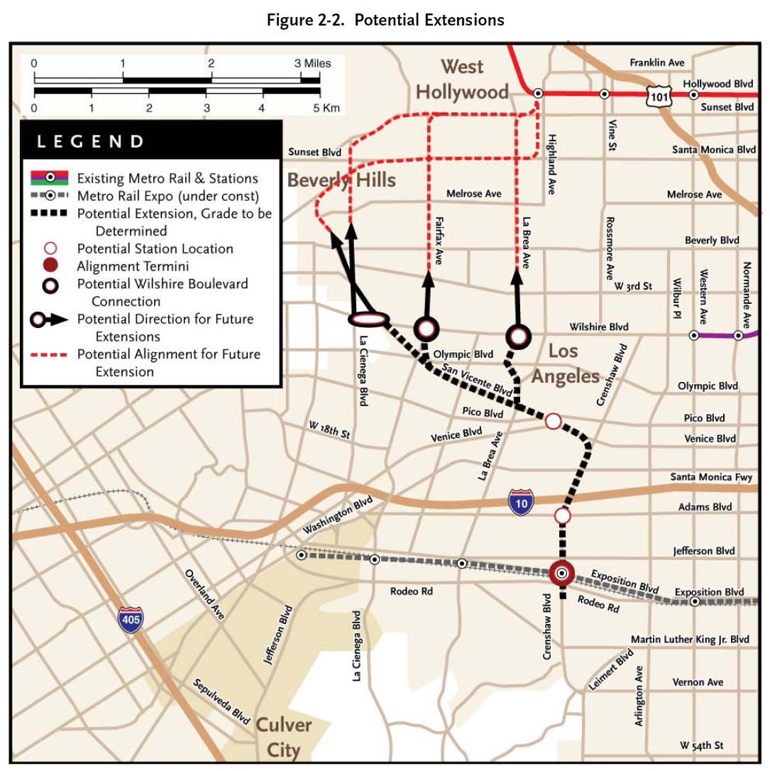 |
|
|
|
Post by trackman on May 14, 2010 4:27:50 GMT -8
That is interesting. I suppose there are not many options if one were to remain in the right of way.
|
|
|
|
Post by Dan Wentzel on May 14, 2010 8:29:03 GMT -8
If Metro commits to the Pink Line, then the most likely scenario is a straight shot up LaBrea.
However, if Metro gives up on a Santa Monica Blvd. connector as a part of the Westside subway extension, the most likely scenario would be a SanVicente/Santa Monica line extension of the Crenshaw Line.
I was speaking to a Metro representative at the last community forum for the Westside Subway Extension at the Pacific Design Center and asked off the record about the worst case scenario for the Pink Line should Metro eventually decide not to do it as part of the Westside Subway Extension.
This representative pointed to the Crenshaw maps showing new possible alignments for the northern extension of the Crenshaw line instead of LaBrea and stated that Metro would have already invested significant time, money and resources studying and planning for a Santa Monica Blvd. alignment, and that is the alignment the community and civic leaders are already invested in.
Personally, I think the second choice would be a Fairfax alignment as Fairfax was the originally planned northbound Red Line route before Vermont.
If the Pink Line is not done, I don't see a simple straight shot up LaBrea as the Crenshaw northern extension, because then you miss BOTH the high ridership points of the Beverly Center area and the Grove/Farmer's Market area. LaBrea isn't considered "westside" and you'd miss out higher ridership opportunities.
I would like to see both the Pink Line built and a Crenshaw Line going up Fairfax, with a transfer station at Santa Monica & Fairfax. Both the Beverly Center area and the Grove area would be served as well. But if the Pink Line is built, I see the La Brea alignment happening. If not, then I expect a Fairfax or San Vicente alignment.
|
|
|
|
Post by metrocenter on May 14, 2010 10:05:42 GMT -8
The La Cienega route is best if the primary goal is expanding coverage. The La Brea route is best for a straight, fast crosstown train. The Fairfax route is a compromise that hits destinations (but not West Hollywood) and is more direct (but not as direct as the La Brea route).
I'm leaning more and more toward the La Brea route. Even though it has fewer destinations, it will provide a very fast ride from the Red Line to LAX, and from Crenshaw into Hollywood.
|
|
|
|
Post by erict on May 14, 2010 10:17:42 GMT -8
I think that the further west the line goes the better, San Vicente or Fairfax, but not LaBrea, that is if CS2 is actually replacing the Pink line.
|
|
|
|
Post by Dan Wentzel on May 14, 2010 10:29:33 GMT -8
I'm leaning more and more toward the La Brea route. Even though it has fewer destinations, it will provide a very fast ride from the Red Line to LAX, and from Crenshaw into Hollywood. It all depends on the Santa Monica Blvd. alignment staying in the Westside subway extension. A Fairfax alignment would be nearly as fast as a LaBrea alignment and would have higher ridership potential. |
|
|
|
Post by metrocenter on May 14, 2010 10:59:13 GMT -8
Here is a map with Crenshaw Line on La Brea, plus the Pink Line through WeHo. 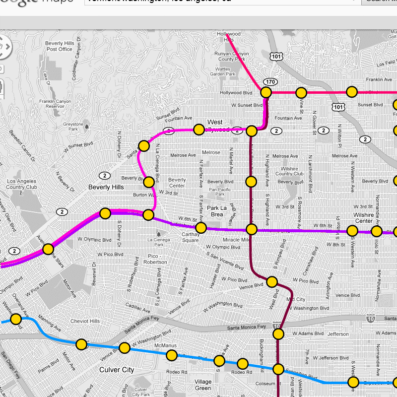 |
|
|
|
Post by Jason Saunders on May 14, 2010 12:49:43 GMT -8
Here is a map with Crenshaw Line on La Brea, plus the Pink Line through WeHo.  I like this the best but I don't think they'll be using the same track between Hollywood and Santa Monica, due to power source and platform widths. If they were to choose this alignment would a tunnel large enough to support both tracks be the way to go or separate tunnels? Four tunnels? Also, as long as they are tunneling that area between Wilshire and Adams can be straightened out and I would consider moving the San Vicente/Venice station to La Brea/Venice. |
|
|
|
Post by metrocenter on May 14, 2010 14:22:38 GMT -8
Also, as long as they are tunneling that area between Wilshire and Adams can be straightened out and I would consider moving the San Vicente/Venice station to La Brea/Venice. That's a good point, I hadn't thought about the possibility of a station at La Brea/Venice. But you'll still have one (two actually), due to the imperfect angle of La Brea, and the fact that it'll probably need to cross the 10 Freeway under Crenshaw Blvd. 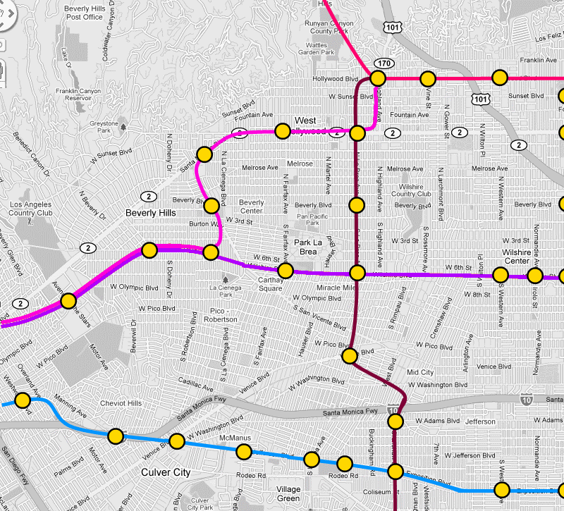 I wonder, though, how valuable it is to have a station at La Brea/Venice. La Brea is already well-served by this line, whereas in this option San Vicente gets no station at all. |
|
|
|
Post by James Fujita on May 14, 2010 18:02:29 GMT -8
Mid-City isn't my forte, but it looks like the LaBrea/ Venice station, as pictured above, would be on a curve.
It also looks like Venice, Pico and San Vicente are awfully close together at that point. An underground station might be able to split the difference between a couple of those streets.
|
|
adamv
Junior Member
 
Posts: 51
|
Post by adamv on May 14, 2010 22:28:20 GMT -8
Mid-City isn't my forte, but it looks like the LaBrea/ Venice station, as pictured above, would be on a curve. It also looks like Venice, Pico and San Vicente are awfully close together at that point. An underground station might be able to split the difference between a couple of those streets. Actually, I think what they're planning with this is a stop very close to the Pico/Rimpau transit center: www.transitunlimited.org/Pico/Rimpau_Transit_CenterWhen Crenshaw was first suggested, I thought that it would go at LEAST as far as this location, since it's such a nexus for a lot of people - PLUS, it's across the street from a future Lowe's-anchored shopping center that'll be opening in a year or two (I think, there have been countless delays). It's very close to where Pico and Venice cross, walking distance to La Brea, there's a fair amount of real estate to build. It's also (ahem) about 8 blocks from my house, so I'm salivating at the idea. Expo isn't far, but having a trip to LAX within walking distance is incredibly exciting. |
|
|
|
Post by jeisenbe on May 14, 2010 22:55:17 GMT -8
The mid-city station should be between Venice and Pico at San Vincente. Remember that many or most riders will be transferring from buses or other trains on this cross-town line. San Vincente has a local bus and an express (freeway) bus. Venice has buses every 10 to 12 minutes during the day, local and limited-stop (better than some Rapid routes). Pico has a BBB and Metro Rapid, and frequent local buses; in fact, the infamous Rimpau transfer center is right where San Vincente meets Pico, just north of Venice (Bus riders have to transfer from Metro to the Big Blue Bus here to continue east or west, due to history and inertia). (Metro needs to get its maps off of pdf. I wish I could link them more easily: www.metro.net/around/maps/ ) La Brea also has pretty good bus service, but the east-west transfers will be much more important on this route. A 100 to 200 meter long station would fit nicely between Pico and Venice, with portals at both ends. The satellite image on google maps shows an undeveloped lot; I hope this land is still available for a station: 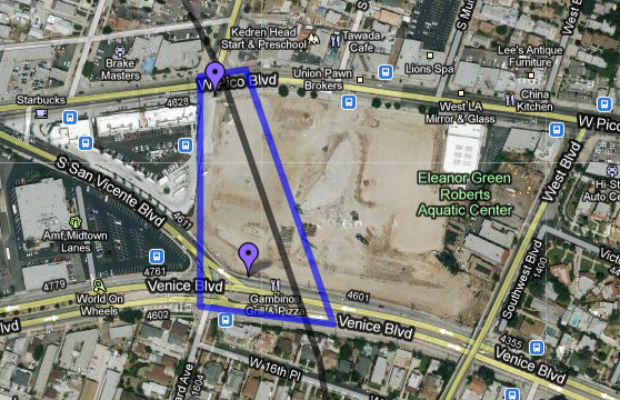 |
|
|
|
Post by jeisenbe on May 14, 2010 23:03:21 GMT -8
If both lines are built, Metro should consider where the "Pink Line" might go after Wishire/La Cienega. Sharing tracks with the Purple Line will require a junction and will limit capacity on this major route, which may very well need trains every 2 minutes at rush hour, some day. Since Metro has no plans to run Pink Line trains to North Hollywood, light rail would be reasonable. In this case, I don't see why Metro would build two different routes from La Brea & Santa Monica and Hollywood & Highland; instead, the two routes could share tracks and a station: 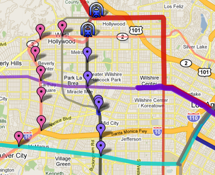 As an alternative, the Pink Line could instead continue east on Santa Monica, eventually going all the way to East Hollywood, Silverlake, and then Union Station. If both routes are built there is less need for travelers from The Valley to get to the Pink Line directly, since the Crenshaw line would be the quickest route to Wilshire (unless the Pink Line shares tracks further west, which would save one transfer and make up for the less direct route). See the full map by opening up both these maps: 1) Metro in 2014: maps.google.com/maps/ms?ie=UTF8&hq=&msa=0&msid=102764232639575421873.00046b0a527ac3df4da27&ll=34.076834,-118.3255&spn=0.136213,0.265388&z=12 2) 2050 plans?: maps.google.com/maps/ms?ie=UTF8&hl=en&msa=0&msid=102764232639575421873.000478eb6d5e55331db2b&ll=34.078256,-118.304901&spn=0.136211,0.265388&z=12 |
|
|
|
Post by James Fujita on May 15, 2010 16:57:07 GMT -8
The mid-city station should be between Venice and Pico at San Vincente. Remember that many or most riders will be transferring from buses or other trains on this cross-town line. San Vincente has a local bus and an express (freeway) bus. Venice has buses every 10 to 12 minutes during the day, local and limited-stop (better than some Rapid routes). Pico has a BBB and Metro Rapid, and frequent local buses; in fact, the infamous Rimpau transfer center is right where San Vincente meets Pico, just north of Venice (Bus riders have to transfer from Metro to the Big Blue Bus here to continue east or west, due to history and inertia). (Metro needs to get its maps off of pdf. I wish I could link them more easily: www.metro.net/around/maps/ ) La Brea also has pretty good bus service, but the east-west transfers will be much more important on this route. A 100 to 200 meter long station would fit nicely between Pico and Venice, with portals at both ends. The satellite image on google maps shows an undeveloped lot; I hope this land is still available for a station:  From what I understand, the property outlined on that map is destined to become a Lowe's. Which is unfortunate, because I can think of few retailers, other than auto-related businesses, that would be less transit-friendly than home improvement stores. People aren't apt to buy cans of paint, lumber or powertools and take it home with them on the bus or on the train. The situation sort of reminds me of the Home Depot in Little Tokyo; great location for transit, horrible existing use for it. (I'm not opposed to home-improvement stores except when they pop up in potential TODs.) |
|
|
|
Post by trackman on May 15, 2010 21:57:44 GMT -8
If both lines are built, Metro should consider where the "Pink Line" might go after Wishire/La Cienega. Sharing tracks with the Purple Line will require a junction and will limit capacity on this major route, which may very well need trains every 2 minutes at rush hour, some day. Since Metro has no plans to run Pink Line trains to North Hollywood, light rail would be reasonable. In this case, I don't see why Metro would build two different routes from La Brea & Santa Monica and Hollywood & Highland; instead, the two routes could share tracks and a station:  As an alternative, the Pink Line could instead continue east on Santa Monica, eventually going all the way to East Hollywood, Silverlake, and then Union Station. If both routes are built there is less need for travelers from The Valley to get to the Pink Line directly, since the Crenshaw line would be the quickest route to Wilshire (unless the Pink Line shares tracks further west, which would save one transfer and make up for the less direct route). See the full map by opening up both these maps: 1) Metro in 2014: maps.google.com/maps/ms?ie=UTF8&hq=&msa=0&msid=102764232639575421873.00046b0a527ac3df4da27&ll=34.076834,-118.3255&spn=0.136213,0.265388&z=12 2) 2050 plans?: maps.google.com/maps/ms?ie=UTF8&hl=en&msa=0&msid=102764232639575421873.000478eb6d5e55331db2b&ll=34.078256,-118.304901&spn=0.136211,0.265388&z=12 Something like that Pink Line dashed down to Venice and southwesterly entered my thoughts too. And, so long as we're exploring ideas, below (hopefully) is a map done showing something similar plus Crenshaw extended up to Hollywood/Highland via La Brea/Santa Monica. A line from Venice and through West Hollywood and along Santa Monica is appealing to me. I suppose Washington is another choice versus Venice. Other than that, I assume it's almost exclusively underground and light rail and having stations closer together as compared to the Red Line. A couple more key elements, the Venice Line could have a shared station at Santa Monica between La Brea and Highland and perhaps continue through the hills to Glendale or down Sunset by Dodger Stadium and to Union Station. It's big, hopefully will show up. And, the link. yfrog.com/j8bigwestsidewfullj Map modified to be smaller |
|
|
|
Post by jeisenbe on May 15, 2010 22:34:07 GMT -8
You might want to resize that image.
I'm stealing these ideas from Damien Goodmon, of all people. ;-)
He suggested a "silver line" from Venice, thru West Hollywood, down Sunset to Union Station, and eventually east along the Gold Line Eastside extension, then south down Atlantic all the way to Artesia Transit Center. Whew!
I'm not sure where such a line should continue further east, or south, from Union Station, but there are several corridors in that area that have been considered. Going north-east to Glendale would also be a good idea, though I think a north-south line from Burbank to Glendale and then Union Station would be the first priority in that area.
|
|
|
|
Post by trackman on May 15, 2010 22:58:36 GMT -8
You might want to resize that image. I'm stealing these ideas from Damien Goodmon, of all people. ;-) He suggested a "silver line" from Venice, thru West Hollywood, down Sunset to Union Station, and eventually east along the Gold Line Eastside extension, then south down Atlantic all the way to Artesia Transit Center. Whew! I'm not sure where such a line should continue further east, or south, from Union Station, but there are several corridors in that area that have been considered. Going north-east to Glendale would also be a good idea, though I think a north-south line from Burbank to Glendale and then Union Station would be the first priority in that area. It's now smaller. Then, people are thinking alike, tho, this is largely fantasy thinking and for just fun. |
|
|
|
Post by jeisenbe on May 16, 2010 13:21:23 GMT -8
Thanks, trackman.
I think your route for Crenshaw Phase 2 has too many stations. In an ideal transit system, stations every 1/2 mile would be great, but with the cost of cut-and-cover stations and bored tunnels, stations 1 mile apart are more realistic. Fortunately, the major bus routes are also spaced 1 mile apart in most of the route (with Washington being an unfortunate exception; Pico and Venice are also both important routes, but are close enough to be served by 1 station.
The "Pink Line" extension to Venice and East Hollywood might be able to have stations every 1/2 to 3/4 along Santa Monica and Venice Blvd (as shown on your map), if those sections could be at-grade or elevated rather than underground. The north-south section of that line between Beverly Hills and Culver City would almost certainly be bored tunnel subway, unless we have a dictator force thru an elevated route via imminent domain. With a realistic subway option, you get stations at Pico, Wilshire, Beverly and Santa Monica west of La Cienega, two stations less than your map.
There is some advantage to increased station spacing; 1/2 mile spacing results in 25 mph average speeds (since you can only get to 60 mph with 2 mph per second (1 m/s^2)a acceleration and deceleration), while 1 mile spacing can get you up to 35 mph average speeds, with new trains capable of 90 mph in tunnels.
(Math: 20 seconds average stop time per station, 40 seconds to accelarate to 90 mph (40 m/s), 40 seconds to decelerlate = 100 seconds per mile, = 35 mph. Google Maps confirms the current purplel line manages just under 24 mph for the section with stations every 1/2 mile or so)
For a trip from 4th st, Santa Monica, to 7th St / Metrocenter in LA, that would save 10 minutes; optimal times are 27 minutes versus 37 minutes. If the subway-to-the-sea is finished with the planned number of stations and the current 70 mph max speed, it could take about 33 minutes from Metrocenter to 4th street; assuming 30 mph average for the 12 mile-long new section (due to wide station spacing, but 70 mph max; also, Hollywood / Vine to Wilshire / Western currently averages 30 mph), and using the current 8 minute time from Wilshire/Western to Metrocenter.
The bus plus subway takes 1.5 hours on this route today.
|
|
|
|
Post by trackman on May 16, 2010 13:46:57 GMT -8
^^^ Thanks. I was less motivated by station spacing than routing. And, I honestly did fret over how many stops and their spacing, but instead selected more knowing that trip times would be longer. But, it is just for fun, right?
Using the screen capture and paint is new to me too, so I was learning as I was going. I've tried using the Google Maps, mymaps tools, but found them too limiting. However, those are more easily sharable.
|
|
|
|
Post by jeisenbe on May 16, 2010 13:47:22 GMT -8
When considering the best station spacing, don't forget that a rapid bus (or streetcar?) can average up to 20 mph with stops, when traffic is light. Try the calculation with 15 m/s max speed (35 mph), 1 m/s acceleration (2 mph/s), and 800 meters (1/2) mile between 20 second stops. Of course, once you have more than a few people on the bus or if you run into traffic the speed is soon down to 15 mph or less. But with improvements like rush-hour bus lanes or queue jump lanes, signal priority, near-level boarding, proof-of-payment and all-doors boarding, 20 mph average speeds should be possible on "BRT" routes. Light rail at grade can also average 20 mph, if given signal preemption, even with stations every 1/2 mile and 35 mph max speeds.
If Wilshire or another street is going to get good rapid buses, then it makes more sense to design a 30 or 35 mph subway with stations every 1 mile than a 20 to 25 mph subway with frequent stops. It will cost more to operate the buses, but subway stations are hugely expensive, outweighing any operations savings costs, unless capital funding is limitless.
|
|
|
|
Post by trackman on May 16, 2010 15:07:49 GMT -8
^^^ Yes, I agree. Thanks.
|
|
|
|
Post by metrocenter on May 17, 2010 9:39:52 GMT -8
Let's not overestimate the importance of close station spacing. Much more important is the design of the street, the presence of local transit, and the configuration of the neighborhood around the station.
There are many great examples around the world of subway corridors that really made the most of their subway stations. Examples include Market Street in San Francisco, Broadway in NYC, Blvd Maisonneueve in Montreal, Charing Cross Road in London, etc. Even in places where stations are a full mile apart, the distance can be acceptable as long as (1) the streetscape is well-designed and walkable, and (2) there are other surface modes of transit (through buses, circulator buses and taxis, for example) to supplement the subway.
Unfortunately, our streets and transit systems in L.A. are not designed holistically like this. Instead, we build a subway and hope that everything else will come together by magic.
A perfect example is Wilshire between Western and Vermont. Three subway stations within a mile, plus high-rise office towers surrounded by ultra-dense residential. But even with all that, where are the taxis, where are the local circulators to take advantage of that density? How about maps of the neighborhood showing what is nearby and how to get there? Compared to the cost of an extra subway station, these basic features are all ultra-cheap, yet for some reason they are still missing from our subway neighborhoods after all this time.
|
|
|
|
Post by tobias087 on May 18, 2010 1:20:55 GMT -8
Well, they do have these maps at most of the stations, including the purple line. (On an aside, I hadn't known about the odd curve of the Purple line until I looked at the Vermont station map) www.metro.net/around/maps/rail-connections/ |
|
|
|
Post by wad on May 18, 2010 4:11:41 GMT -8
The situation sort of reminds me of the Home Depot in Little Tokyo; great location for transit, horrible existing use for it. Isn't that the Office Depot on that block of 1st, Alameda, 2nd and Central? |
|
|
|
Post by metrocenter on May 18, 2010 9:50:58 GMT -8
Well, they do have these maps at most of the stations, including the purple line. (On an aside, I hadn't known about the odd curve of the Purple line until I looked at the Vermont station map) www.metro.net/around/maps/rail-connections/Yes, maps at the stations. But no maps along the route, like for example near the bus stops. |
|
|
|
Post by jeisenbe on May 20, 2010 1:11:38 GMT -8
Well, they do have these maps at most of the stations, including the purple line. (On an aside, I hadn't known about the odd curve of the Purple line until I looked at the Vermont station map) The curve of the Purple Line west of Vermont should allow the Vermont subway to be continued south, with cross-platform transfers at Wilsher/Vermont. If both lines came together heading straight east-west it would be hard to go south again. At least this is one place where there was good planning for the future. |
|