|
|
Post by darrell on Mar 27, 2009 19:13:22 GMT -8
Good update, Gokhan. Here are two photos today of the deck of the Ballona Creek bridge looking ready to pour concrete. Note the track the yellow structure rides on. I presume that's how they'll pump the concrete across the deck. 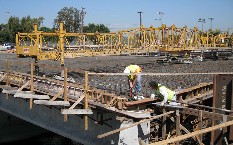 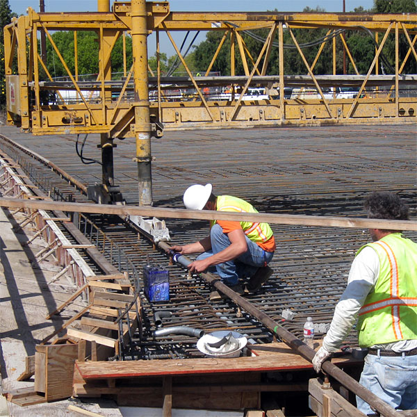 Here's the whole photo gallery so far. |
|
|
|
Post by darrell on Apr 3, 2009 14:38:56 GMT -8
On Wednesday (March 31) the new Ballona Creek concrete bridge deck was covered for curing. 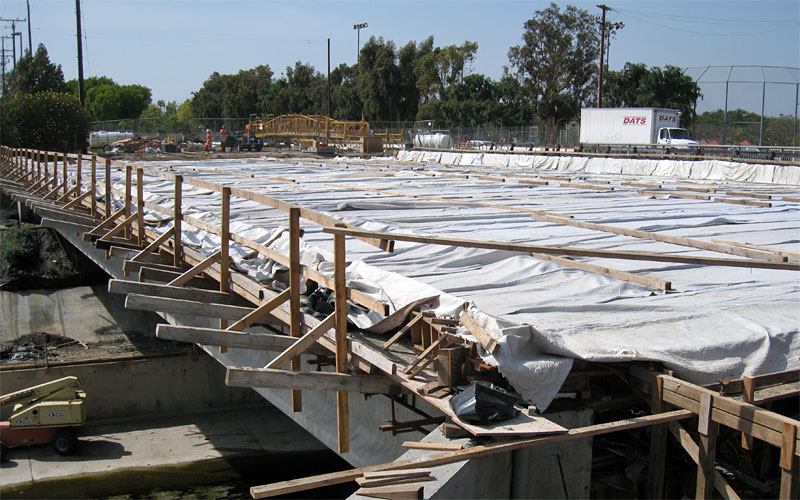 And the falsework for the La Brea bridge had a number of the supporting steel girders up. Note the lower levels on the sides for the track bridges and the higher level in the center for the station platform. 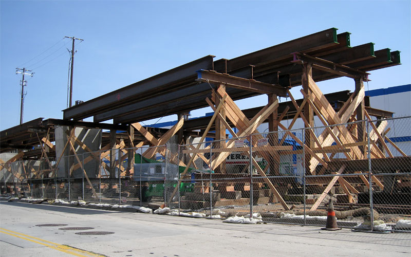 |
|
|
|
Post by Gokhan on Apr 3, 2009 14:44:50 GMT -8
^^
I beams seem to greatly ease and speed up the construction of these bridges; so, hopefully, this will be fast.
|
|
|
|
Post by kenalpern on Apr 3, 2009 16:28:46 GMT -8
Can anyone give us a concise explanation of "falsework" for those of us laypeople?
I usually refer to that term when my wife and I seem to do a lot of work around the house but yet nothing gets done...but I suspect there's another definition here!
|
|
|
|
Post by Gokhan on Apr 3, 2009 17:12:23 GMT -8
^^
falsework (circa 1874): temporary construction work on which a main work is wholly or partly built and supported until the main work is strong enough to support itself
I think we might see this bridge coming to life by the summer.
Meanwhile they are starting to drill the CIDH (cast-in-drilled-hole) foundations of the Venice/Robertson structure, on which Fix Expo are threatening their April 24 nuclear attack.
|
|
|
|
Post by Gokhan on Apr 4, 2009 11:47:33 GMT -8
Here are the latest pictures from the La Brea Station, as of 7:30 PM yesterday. It looks like the placement of the I bars on the east side is complete. They should soon start the rebar cages for the crowns and casting afterwards. On the west side, you can see a crane working. One of the supports is already erected there as well. This was delayed by the LADWP removal of the aerial power lines. This is still delaying the east side of the La Cienega station, where two supports next to La Cienega are waiting to be built. 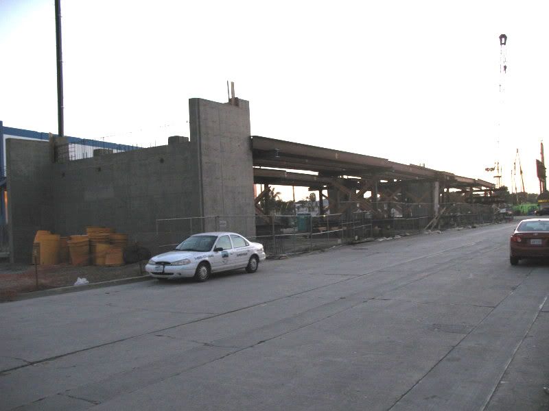 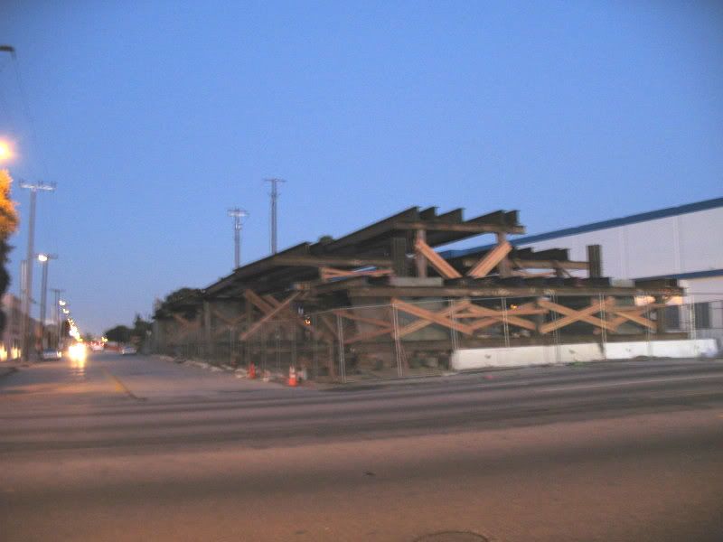 |
|
|
|
Post by darrell on Apr 6, 2009 21:52:34 GMT -8
I noticed short lengths of rail are being welded into long ones on the right-of-way east of La Brea.
|
|
|
|
Post by Gokhan on Apr 6, 2009 22:16:15 GMT -8
I noticed short lengths of rail are being welded into long ones on the right-of-way east of La Brea. This is great! This obviously means they are starting to lay tracks. |
|
|
|
Post by Gokhan on Apr 7, 2009 10:23:39 GMT -8
Expo track installation has begun!In-your-face, NIMBYs!  The tracks are being installed by Balfour Beatty. The pictures below are taken near Harcourt Ave, west of Farmdale Ave. Here is the welding of continuous track. 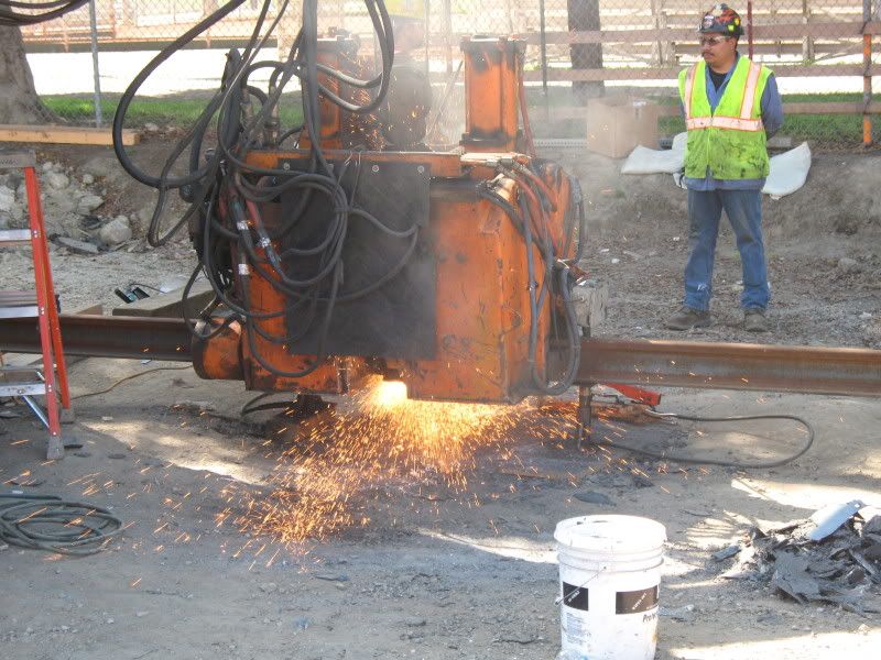 Here is the grinding of the welding joints for the continuous track. 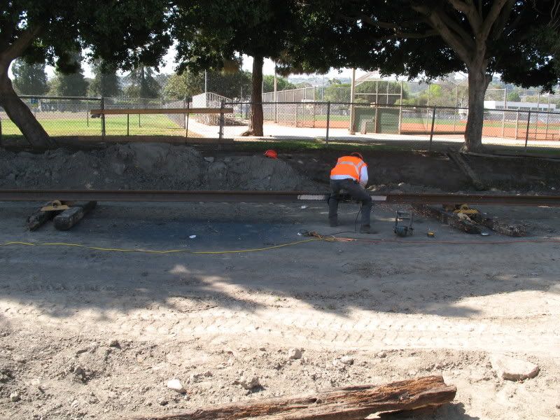 Timing of the track installation can't be any more perfect with Fix Expo's April 24 nuclear attack aimed at destroying Metro and all public transit in LA approaching.
|
|
|
|
Post by kenalpern on Apr 7, 2009 13:55:08 GMT -8
Great photos, Gokhan! Remember that an easy rearrangement of the word "nuclear" is "unclear", and it's certainly unclear what the "attack" will accomplish.
|
|
|
|
Post by Gokhan on Apr 7, 2009 14:56:25 GMT -8
^^ Perhaps they said "unclear," not "nuclear" when they announced this at the Expo board meeting and I heard it wrong. LOL But, regardless, this is great free entertainment! |
|
|
|
Post by darrell on Apr 7, 2009 17:49:55 GMT -8
Here is the welding of continuous track. Great photos, Gokhan! Do you know any details about how it's done? Electric arc welding? |
|
|
|
Post by Gokhan on Apr 7, 2009 19:25:12 GMT -8
^^ It's definitely electric welding. They are basically passing very large currents through the rails to melt them and form a perfect joint. Note that this is much better than thermite welding in which molten iron is poured into the joint. Here is the high-resolution picture. Here is info on Wikipedia. And here is some more info by Holland Co, the company who is doing the rail welding for Expo. Flash-butt welding, the state-of-the-art technology, is what is being used for the Expo Line. The Expo tracks are being installed by Balfour Beatty Rail. The rail was made by in Pennsylvania last year. |
|
|
|
Post by darrell on Apr 8, 2009 12:37:31 GMT -8
These new images are a teaser to visit the refreshed Friends 4 Expo website. It is simplified and updated to reflect the Expo Board's 4/2/09 preferred alignment, plus new and larger photos of the Expo corridor and light rail. Enjoy!  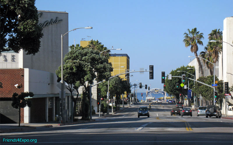 |
|
|
|
Post by stuckintraffic on Apr 8, 2009 15:38:26 GMT -8
How is turning the sears building into a parking lot promoting pedestrianism?
|
|
|
|
Post by Justin Walker on Apr 8, 2009 15:50:15 GMT -8
Wow, it is great to see finally see that! |
|
|
|
Post by darrell on Apr 8, 2009 21:25:49 GMT -8
How is turning the sears building into a parking lot promoting pedestrianism? The City of Santa Monica agrees with your point and is seeking alternatives to a typical park and ride lot at the Sears site. Here's what the City Council staff report says about station parking: Recommended Action
Staff recommends that City Council
...
5. Direct City staff to analyze any additional parking needs (i.e. park-and-ride, kiss-and-ride and bike parking) for each station as part of the City’s station area planning activities and bring back recommendations to City Council before the Expo Authority has finalized parking recommendations.
6. Direct City staff to work with Metro to obtain a waiver or a revised policy so that riders pay for the use of any parking near rail stations within the City of Santa Monica. The current policy of no charge for park-and-ride will encourage people to drive and park at stations.
7. Direct City staff to work with the Expo Authority and the bicycling community to resolve the Expo Bike Path routing and address bike access to the stations.
Parking Needs at Stations: The DEIR includes 225-250 surface park-and-ride spaces on the City’s Sears Automotive site. A better strategy for Downtown would be shared use of the combined pool of parking for the Downtown and Civic Center Area, and possibly some parking as part of a transit-oriented development (TOD) at the station. Staff is currently undertaking a comprehensive analysis of parking for the entire area and will bring the findings to City Council for further consideration in the near future. Staff also plans to analyze the parking assumptions and needs at the other two stations through station area planning efforts. Currently the DEIR assumes approximately 70 spaces at the 17th Street Station for the Colorado alignment and no spaces at the Bergamot Station. Staff will bring back recommendations to City Council before the Expo Authority has established parking recommendations as part of the “Final” project.
Parking Charges at Stations: Staff will work with Metro, the future rail operator, to seek a waiver or revision to the current policy of providing park-and-ride spaces free of charge. Free parking will encourage people to drive to the stations and increase auto traffic near the stations. The issue of free parking is only applicable where spaces are built and owned by the regional agencies rather than the City of Santa Monica. Pricing for City-owned spaces would be determined by the City. To encourage patrons to access stations through alternative means, Santa Monica intends to serve the stations through enhanced Big Blue Bus community transit service, bicycle and pedestrian amenities. Station area planning will also explore the accommodation of “kiss-and-ride” drop-off locations. |
|
|
|
Post by kenalpern on Apr 8, 2009 22:00:55 GMT -8
I couldn't give a rip whether it's free or paid parking at this site. There is no Metrolink in the area and this Expo Line will serve that need to some degree. Bikes, buses and parking will ALL be needed to make sure that everyone, with their own individual situations and preferences, will enjoy access to the Expo Line and ensure peak ridership in a few years.
|
|
|
|
Post by stuckintraffic on Apr 8, 2009 23:24:30 GMT -8
About the plans for the Sears site -- that's terrific. The drawings of the site used for comparison of Olympic and Colorado alignments had it looking like a very boring surface parking lot a la the Orange line terminus at NoHo. This site needs a TOD... it could be cool -- the train could pull into a garage-like station under retail, office, etc.
Related to that -- has anyone proposed running the train on the south side of Colorado instead of in the middle? Renderings show the train operating in the middle of the street with 1 lane on one side and 1 lane of traffic and 1 lane of parking on the other, but if they ran it on the south side, it would eliminate the need for the train to cross traffic as it turns out from 4th/Colorado station to Colorado Ave.
The main reason I liked the Olympic option is because it minimized at-grade crossings. If they ran the train on the south side of Olympic, there would be 1 fewer at grade crossing (actually 2 if you count the train having to cross traffic to get into the middle of the boulevard over by 17th street)
|
|
|
|
Post by metrocenter on Apr 9, 2009 7:29:14 GMT -8
The City of Santa Monica wants to discourage parking at the downtown station, for the same reason L.A. wouldn't want parking for transit at Metro Center. Downtown SM is very dense with lots of traffic, and adding transit parking would be counterproductive to the goal of reducing the number of cars in Downtown SM.
People driving to Expo should be directed to 17th Street or Bergamot. Those are more appropriate locations for transit parking.
|
|
|
|
Post by darrell on Apr 9, 2009 9:08:49 GMT -8
Related to that -- has anyone proposed running the train on the south side of Colorado instead of in the middle? I expect the reason not to is the private driveways on the south side of Colorado, and perhaps difficulties with right turns off of Colorado. On the configuration of Colorado, did you see the part about Santa Monica seeking to narrow the trackway in order to retain street parking on both sides? Wires would span from side poles rather than center pole catenary, and it requires a CPUC waiver. |
|
|
|
Post by Gokhan on Apr 9, 2009 10:45:44 GMT -8
On the configuration of Colorado, did you see the part about Santa Monica seeking to narrow the trackway in order to retain street parking on both sides? Wires would span from side poles rather than center pole catenary, and it requires a CPUC waiver. To me it looks like City of Santa Monica is trying to micromanage the project. Micromanagement usually results in inferior outcomes. Do you know what distance they are asking for between the centers of the tracks? I want to calculate how much space will be left between the two trains. I'm worried that in such a pedestrian zone, people could get squeezed between the two trains. Inferior design that lacked necessary safety considerations at the pedestrian crossings is what resulted in the high Blue Line death toll; so, this is something that needs to be taken seriously. |
|
|
|
Post by darrell on Apr 9, 2009 12:00:01 GMT -8
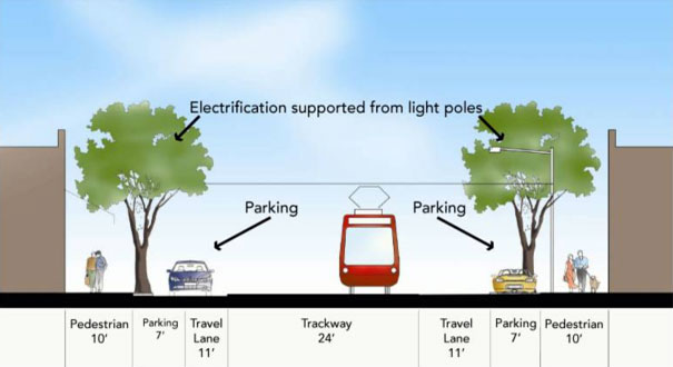
Do you know what distance they are asking for between the centers of the tracks? In the 2005 Phase 1 Final EIS/EIR (Chapter 2) the track center-to-center dimension with center catenary poles was 14 feet. But on the Hill Street section with span wire across the street, and in sections along Exposition Blvd. where the poles are on the side of the median, it was only 11'-2" between track centers. This is what that same City Council staff report said on this subject (but no dimensions): Explore Possible Narrowed Rail Cross-Section for Colorado Alignment: The City’s transportation expert has analyzed at-grade street sections with narrower track-way widths in other California cities and believes that a narrower configuration could work on Colorado Avenue, so that parking could be maintained on both sides. The photo below shows the Judah Street light rail line in San Francisco, which is the same width as Colorado Avenue and has parking on both sides. This configuration would also better facilitate truck turning radius requirements. The California Public Utilities Commission (CPUC) would have to approve a narrower cross-section. Staff can explore this proposal with the CPUC and the Expo Authority.
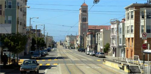
Colorado could have the same transit-way configuration as Judah Street in San Francisco
Judah Street is also 80’ wide and has parking on both sides of the street
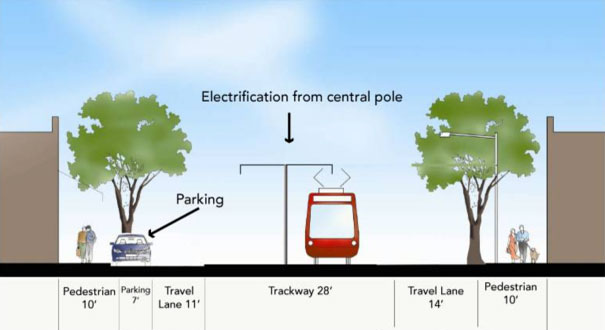
The earlier February 10 City Council staff report gave more information. First, the original Colorado proposal with a 28-foot median, then the proposal for a narrowed 24-foot median: Exhibit D: Colorado Alternative Cross-Section
...
Parking Impact: The proposed cross-section for the street-running portion of the Colorado alignment preserves on-street parking on the north side of the street. The Expo Authority has identified removal of approximately 75 spaces on the south side but also has identified potential replacement parking. The Expo Authority has said that they will continue to work with the City to develop a feasible replacement strategy.
The City’s transportation expert prepared an alternative street/LRT section on Colorado Avenue from 5th to 16th Streets which would reduce the track-way width to 24’ (similar to other cities) with parking maintained on both sides. The proposed alternative replaces the center power catenary poles between the tracks with a support system utilizing the street lights on either side of the street. This configuration would also better facilitate truck turning radius for driveway, alley and cross street access. The DEIR does not recommend this alternative, however staff believes it is a preferable solution and worthy of continued discussion with the Expo Authority. This configuration is successfully used in other California Cities.
Exhibit J: Proposed Alternative Cross-Section for Colorado with Parking on Both Sides
|
|
|
|
Post by Gokhan on Apr 9, 2009 13:51:07 GMT -8
^^ Thanks for the layouts. This is what happened when City of Santa Monica brought the tracks closer than the standard on their monorail:  OK, that was actually City of Seattle. LOL The dynamic width of the trains is 11.2 ft. Dynamic width accounts for the shakings as well as turns. The static width is 8.7 ft. I don't think it includes the mirrors or other protrusions though. The walkway in the center is equal to (Distance between the centers of the tracks) - (Width of one train). For 11.2 ft separation, you get 11.2 - 11.2 = 0 ft distance between two dynamic trains (at curves). So, this is the absolute minimum, the trains almost barely touching each other at curves, with no space in between. The standard walkway is 2.5-ft-wide. Usually a walkway both to the left, to the right, and at the center is left. Using the dynamic widths and these, you get 2.5 + 11.2 + 2.5 + 11.2 + 2.5 = 29.9 ft. This is the standard right-of-way width for light-rail transit. This was used exactly (29.9 ft) for the USC trench. Let's now squeeze the two trains closer. If we ignore the dynamic widths and use static widths, you would need a minimum right-of-way width of 2.5 + 8.7 + 2.5 + 8.7 + 2.5 = 24.9 ft. Therefore, 24.9 ft is the absolute minimum you can have without serious risks to pedestrians and vehicles. Note also that perhaps by coincidence this configuration corresponds to the minimum track spacing possible with the dynamic considerations I described above: 8.7/2 + 2.5 + 8.7/2 = 11.2/2 +11.2/2 = 11.2 ft = dynamic width of a train. So, 24 ft no but 24.9 ft perhaps OK. Incidentally the box structure under the Santa Monica Freeway near Motor Ave is 25.0-ft-wide. But this doesn't fully account for the dynamic width of the trains for safety, and you would need wider spacing where there are turns or high-speed operations. But, again, 24.9 ft is perhaps sufficient for straight-track and 35 MPH segments. |
|
|
|
Post by Gokhan on Apr 9, 2009 15:55:26 GMT -8
Check this out: Fed-up residents to finish Expo Line in six months and for freeOK, it's not really about the Expo Line. The government told them it would cost $4 million and it would take years to repair the road. The fed-up residents did it themselves in eight days for free. This is how I feel about the Expo Line dragged by the NIMBYs and inflated by the ever-rising design - build costs. |
|
|
|
Post by davebowman on Apr 10, 2009 10:34:38 GMT -8
When I went to the informational meeting at the Santa Monica Civic Center a few weeks ago, the transit expert for SM explained why they think they can have the narrower alignment along Colorado to preserve parking but still avoid safety issues. If I understood him correctly, I think they basically want to fence off the median ROW along Colorado so the only pedestrian access points are the intersections. In my opinion the SM City Council has been a bit schizophrenic about light rail, strongly endorsing it but not wanting to give up any parking, opposing the Stewart Street yard, etc.
|
|
|
|
Post by Gokhan on Apr 11, 2009 16:44:20 GMT -8
Here is the latest list of Expo stations after the Phase 2 DEIR. Note that with the Washington/National Station now replaced by the Venice/Robertson Station, Phase 1 became 8.7 miles and Phase 2 became 6.5 miles, the total length of the project using the chosen Pacific Electric Santa Monica Air Line right-of-way and Colorado alignment being 15.2 mile, about 0.1 miles shorter than an Olympic alignment. If the Venice/Sepulveda diversion was chosen, the line would be 1.0 mile longer. 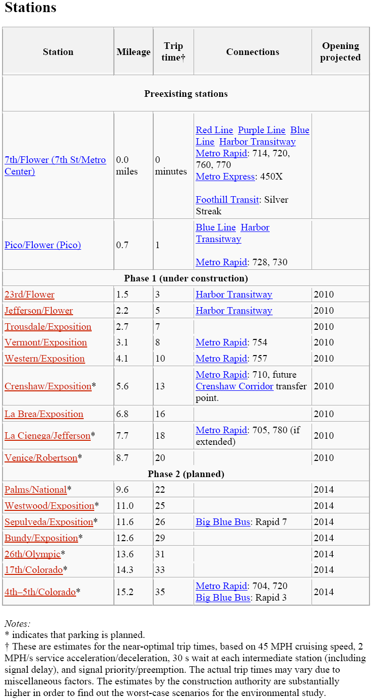 Note that the trip times represent the best-case scenarios with fast LRVs (meaning acceleration and deceleration of 2 MPH/s or more) and signal priority. Otherwise, they could be up to about 5 min more. Also note that the same formula used gives the correct result for the Blue Line 7th St - Willow St trip time as well as the Gold Line Union Station - Sierra Madre Blvd trip time. |
|
|
|
Post by Gokhan on Apr 21, 2009 14:38:21 GMT -8
These meetings are by far the best way of learning about the details and inside information on Expo Phase 1. You get to meet people who work for the design - build, as well as Expo. And Fix Expo make sure bring their cynicism to these meetings, in this particular one their gloom on the eve of the nuclear attack.  Thursday, 4/23/09 6:30pm Downtown & Mid-Corridor Project Status Update MeetingHolman United Methodist Church White Hall Room 3320 W Adams Boulevard Los Angeles CA 90018 (On-site free parking is available) Notice |
|
|
|
Post by Jason Saunders on Apr 21, 2009 20:37:01 GMT -8
These meetings are by far the best way of learning about the details and inside information on Expo Phase 1. You get to meet people who work for the design - build, as well as Expo. And Fix Expo make sure bring their cynicism to these meetings, in this particular one their gloom on the eve of the nuclear attack. Thursday, 4/23/09 6:30pm Downtown & Mid-Corridor Project Status Update MeetingHolman United Methodist Church White Hall Room 3320 W Adams Boulevard Los Angeles CA 90018 (On-site free parking is available) NoticeThanks Gokhan, This is super close to me. I'll be there. 6'1 white guy dressed in black and a red tie. Anyone who would like to please say hello. |
|
|
|
Post by Gokhan on Apr 23, 2009 19:19:16 GMT -8
I was at the meeting tonight and got to talk to Roland and Joel, Chief Expo Architect and Expo Phase 1 Director, respectively.
They are hoping to open to Crenshaw in Fall 2010 and to Venice/Robertson in Summer 2011.
Note that Farmdale Ave is what is delaying the west end of the project. They can't build rail across Farmdale; they can't even start designing the pedestrian bridge, until CPUC approval takes place, which is still months away. They need to finish the environmental, receive the public comments, and apply to CPUC in order for the approval to happen. There is also the ongoing discussion right now whether the Farmdale bridge will have elevators or a cascade of ramps for ADA access. Also note that Farmdale Ave is complicating the testing of the trains and opening of the project to Crenshaw only in segments.
Western and Crenshaw station platforms are being built. They will install the grade crossing at Crneshaw.
Note that in the pictures posted a few weeks ago, you can see the curbs on the sides of the right-of-way. It turns out that these are the ballast-retaining curbs, not the street curbs. The ballast will be installed flush with these curbs. The ballast and pole installation should start in a few months.
Venice/Robertson Station has now been completely designed and submitted, just yesterday or so.
LADWP is asking for another two months or so to relocate the power lines on the east side of La Cienega. That's when the construction can proceed there. La Brea power lines have already been relocated.
No sign of Fix Expo at the meeting. Perhaps they are preparing for the April 24 nuclear attack?
|
|


