|
|
Post by jejozwik on Sept 10, 2008 17:11:42 GMT -8
The job density in the Wilshire corridor (as evident from the traffic on I-10 flowing from east to west in the morning and west to east in the evening) justifies the need for heavy-rail there. its not even about the 10 freeway. wilshire blvd is a cluster %^(# all day long, and has some of the heaviest used buses in the county. that and the fact that any other modality would cause a time wasting transfer and/or acquisitions of property or traffic lanes |
|
|
|
Post by Jason Saunders on Sept 10, 2008 21:59:53 GMT -8
Eastside Subway: Union Station, County USC and Cal State L.A. lay roughly in a straight line and are only a few miles a part. This would be a great extension of the Red/purple lines into East L.A.
Santa Monica desirous of at grade: I suspect this has a lot to do with the advocacy of Darrell Clarke. Suffice it to say there will be no crossings similar to that of Dorsey H.S. at Farmdale.
|
|
|
|
Post by Transit Coalition on Sept 10, 2008 22:15:58 GMT -8
Eastside Subway: Union Station, County USC and Cal State L.A. lay roughly in a straight line and are only a few miles a part. This would be a great extension of the Red/purple lines into East L.A. Santa Monica desirous of at grade: I suspect this has a lot to do with the advocacy of Darrell Clarke. Suffice it to say there will be no crossings similar to that of Dorsey H.S. at Farmdale. Uh, I am not sure why this suggestion is being made.. The last time I looked, these points are served directly by the El Monte Busway and also Metrolink to Cal State LA. Why would there need to be a subway extension? (Note: Metrolink stops at CSULA, not the hospital!). |
|
|
|
Post by darrell on Sept 10, 2008 23:16:35 GMT -8
Santa Monica desirous of at grade: I suspect this has a lot to do with the advocacy of Darrell Clarke. No, I'd assumed it would go with the proposal in the 2001 Draft EIS/EIR for at-grade next to the landscaped Olympic Blvd. median, before going aerial along the freeway from 11th to 4th.   City of Santa Monica planning staff recommended the Colorado alternative last fall, developed by consultant Robert Odermatt, who was involved in the design of light rail in downtown Portland and San Jose (photos below). 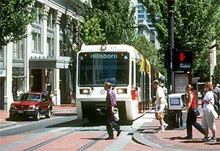 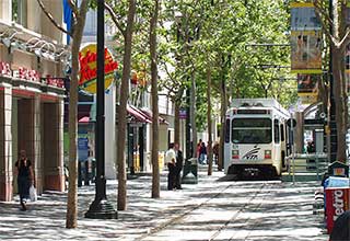 The 10/23/07 staff report to the City Council noted, with the sketch below, “On-grade light rail corridors provide greater opportunities over time for retail businesses, enhanced pedestrian environments and walkable connections to the neighborhoods.”  It came as a surprise to me, but I prefer it for the reasons given. Suffice it to say there will be no crossings similar to that of Dorsey H.S. at Farmdale. Actually there will be both gated (20th Street) and signal-controlled (17th Street) crossings within a half block of school campuses in Santa Monica. |
|
|
|
Post by Jason Saunders on Sept 11, 2008 1:37:51 GMT -8
Darrell, I was wrong on all accounts. My apologies and thank you for informing me.
Bart: You are incorrect to say that there is a Metrolink stop at County USC. There is an expressway stop but it is located in a freeway median away from the hospital. There is a Metrolink stop at Cal State L.A. however just because there are other transportation options available does not mean a major destination center with over 21,000 students should be ruled out.
Additionally, Metrolink serves a different constituency; long distance commuters. The El Monte Expressway too serves long distance commuters. It has exactly two stops in it's eleven mile trek between El Monte and Union Station: County USC and Cal State L.A.. A subway unlike both of these commuter options has much more frequent local stops and serves a much broader spectrum of patrons.
If the subway was to be extended to the East side from Union Station, which it will not anytime soon, those would be two very logical stops to include in the Metro rail network.
|
|
|
|
Post by kenalpern on Sept 11, 2008 5:30:57 GMT -8
I'm grateful, SAUNDERS, that you both:
1) Acknowledged that it wasn't Darrell but the City of Santa Monica who pushed for the at-grade design (and probably caught both of us unawares), since Darrell (who's worked with me for Green Line/LAX advocacy for years) has never had a problem encouraging elevated or trenched light rail when it was indicated. Some folks out there are at-grade or grade-separation "true believers", but Darrell and Bart and myself are all open to (and frequently debate each other) all options.
2) Came up with as excellent an idea as any for an Eastside Red/Purple Line extension. As with the Westside, there will be a need for more than one east-west rail line, and the El Monte Busway and the Metrolink service we now have just doesn't meet all the local needs that the Eastside has and will someday need.
|
|
|
|
Post by Gokhan on Sept 11, 2008 13:43:02 GMT -8
Well, Santa Monica is home to many intellectuals, who were able to move there in those days when the housing was affordable there (not any more!), and apparently Darrell and other Santa Monica intellectuals think the same way and appreciate the image at-grade light-rail will bring to their community. This is in sharp contrast to the people of the Cheviot Hills and similar Westside areas.
|
|
|
|
Post by metrocenter on Sept 11, 2008 15:29:24 GMT -8
Yes, who oh who will save those poor students at Santa Monica Montessori School at 19th and Colorado?
Parents need to teach their kids to take responsibility for their own safety. That goes for safety around trains, around traffic, etc. If their kids are too young, or are otherwise incapable of being responsible in public on their own, then the parents should walk or drive the kids to school.
It's really as simple as that. People need to get into the habit of taking responsibility for themselves, rather than always looking to others for protection or blame.
|
|
|
|
Post by erict on Sept 12, 2008 11:30:14 GMT -8
If all light rail crossing should be 100% grade-separated at all schools, I propose that all vehicular roads as well be 100% grade separated. Cars are dangerous too. Also, people are very dangerous. No sidewalks should come near schools - they should also be grade separated as well.  |
|
|
|
Post by jejozwik on Sept 12, 2008 17:22:51 GMT -8
If all light rail crossing should be 100% grade-separated at all schools, I propose that all vehicular roads as well be 100% grade separated. Cars are dangerous too. Also, people are very dangerous. No sidewalks should come near schools - they should also be grade separated as well. oddly enough they have these really interesting grade seperate crosswalks on busy streets in china   proper link: Pedestrian Bridge over the Nanjing RoadPedestrian Bridge in Guangzhou |
|
|
|
Post by damiengoodmon on Sept 13, 2008 7:08:39 GMT -8
Interesting how Santa Monica came to a completely different determination than Culver City. Not really though. Santa Monica's main opposition to the elevated alignment is it's proximity to land available for development and the "aesthetic impacts." Elevated over the freeway or straight down Colorado Blvd. This elevated structure at the entrance to downtown could detract significantly from the City’s character, scale and desired pedestrian environment. This spin about at-grade light rail being a catalyst for redevelopment while grade separated is not is so contrary to every study that's ever been conducted on the subject it's not even worth addressing. Just do a google search. And again, Santa Monica like so many others confuse a trolley line with the Expo. If they want a trolley line they should build one. |
|
|
|
Post by Gokhan on Sept 13, 2008 10:01:38 GMT -8
Interesting how Santa Monica came to a completely different determination than Culver City. Not really though. Santa Monica's main opposition to the elevated alignment is it's proximity to land available for development and the "aesthetic impacts." Elevated over the freeway or straight down Colorado Blvd. This elevated structure at the entrance to downtown could detract significantly from the City’s character, scale and desired pedestrian environment. This spin about at-grade light rail being a catalyst for redevelopment while grade separated is not is so contrary to every study that's ever been conducted on the subject it's not even worth addressing. Just do a google search. And again, Santa Monica like so many others confuse a trolley line with the Expo. If they want a trolley line they should build one. Goodness, Damien, why don't you get it right for at least once for God's sake? Yes, grade-separated rail is usually more pro-development. But Santa Monica chose at-grade because they wanted to make it "pedestrian friendly", not "car friendly." Also a trolley is a train that shares lanes with cars. Where does the Expo Line share lanes with cars? In the Colorado Blvd median, it will have its own dedicated right-of-way. Perhaps you are the one who "confuses a trolley line with the Expo." |
|
|
|
Post by hooligan on Sept 13, 2008 11:20:24 GMT -8
Interesting how Santa Monica came to a completely different determination than Culver City. Not really though. Santa Monica's main opposition to the elevated alignment is it's proximity to land available for development and the "aesthetic impacts." Elevated over the freeway or straight down Colorado Blvd. This elevated structure at the entrance to downtown could detract significantly from the City’s character, scale and desired pedestrian environment. This spin about at-grade light rail being a catalyst for redevelopment while grade separated is not is so contrary to every study that's ever been conducted on the subject it's not even worth addressing. Just do a google search. And again, Santa Monica like so many others confuse a trolley line with the Expo. If they want a trolley line they should build one. Goodness, Damien, why don't you get it right for at least once for God's sake? Yes, grade-separated rail is usually more pro-development. But Santa Monica chose at-grade because they wanted to make it "pedestrian friendly", not "car friendly." Also a trolley is a train that shares lanes with cars. Where does the Expo Line share lanes with cars? In the Colorado Blvd median, it will have its own dedicated right-of-way. Perhaps you are the one who "confuses a trolley line with the Expo." Regardless though doesn't it help that Santa Monica is the end of the line so running it in the middle of the street works( similar to long beach) and is cheaper then grade seperating it. Seems like the blue line part 2 to me. Its not like Santa Monica isn't already pedestrain friendly and developed. |
|
|
|
Post by damiengoodmon on Sept 13, 2008 13:16:42 GMT -8
Regardless though doesn't it help that Santa Monica is the end of the line so running it in the middle of the street works( similar to long beach) and is cheaper then grade seperating it. Seems like the blue line part 2 to me. Its not like Santa Monica isn't already pedestrain friendly and developed. Depends on the project length, the ridership profile, proximity to destinations and all that jazz. Generally, I think I'm inclined to agree that if you're going to have slow segments it's better to have them at the terminis rather than in the middle. Regardless, I think you'll find a lot of people who would have rather seen the Blue Line enter a tunnel under Pine, and call for that modification today, than the current alignment in Long Beach. |
|
|
|
Post by darrell on Nov 15, 2008 14:42:26 GMT -8
(Cross-posting from the Half-cent sales tax thread) The current Expo phase 2 schedule (from the 11/13/08 Expo Board presentation) is: Administrative Draft EIS/EIR to FTA -- Nov-08
Start Public Hearings on Draft DEIS/DEIR -- Winter-09
Board Adoption of LPA [route decision] -- Winter-09
Request to enter Preliminary Engineering (PE) -- Winter-09 Add another year to complete PE and the Final EIS/EIR -- 2010 Attempts to challenge Final EIS/EIR in court -- 2010 Begin final design and construction -- 2010 Phase 1 was here in early 2006. Thus opening in 2014 is about the earliest we can expect. |
|
adamv
Junior Member

Posts: 51
|
Post by adamv on Nov 15, 2008 15:23:34 GMT -8
I'll take 2014 or 2015 anyday, especially if the Crenshaw line is accelerated.
|
|
|
|
Post by bluelineshawn on Nov 15, 2008 16:23:35 GMT -8
Expo Phase 1 broke ground September 2006. If that can be done in 4 years I would think that 2014 would be the latest for Phase 2 (assuming a normal best case scenario- no lawsuits, major delays, etc.). It seems at least possible that it could be done quicker given that everyone is talking about an "accelerated" schedule because of Measure R.
When I look at the construction of Expo and the gold line extension I'm struck by how few construction workers are actually out there at any one time. If that's the bottleneck and not the engineering then we should be able to greatly accelerate the timeframe. If it's the engineering that slows things down then maybe we're stuck with Phase 2 being constructed at the same pace.
|
|
|
|
Post by Gokhan on Nov 16, 2008 3:33:54 GMT -8
Actually the ground breaking in September 2006 was symbolic. Nothing happened for many months after that.
The initial Expo construction started on May 14, 2007, with some minor utility relocation near USC. The real construction started on July 17, 2007, with the drilling for the CIDH piles for the USC trench.
Phase 1 is 7.5 miles (not counting north of Washington) and Phase 2 is 1 mile shorter at 6.5 miles.
Phase 1 has the following heavy structures: USC trench (0.5 miles long without station), La Brea bridge (0.3 miles long with station), and La Cienega/Ballona viaduct (0.6 miles long with station), and Culver City viaduct (0.5 mile with station). In addition perhaps the pedestrian bridges at Farmdale and Harvard.
Total length of viaducts: 1.4 miles
Total number of viaduct stations: 2
Total length of trenches: 0.5 miles
Total length of at-grade sections: 5.6 miles
Total number of at-grade stations: 6
Estimated time for opening to service after start of construction: 3 years and 3 months = 3.25 years
Phase 2 will have the following heavy structures:
Venice/Robertson bridge (0.2 miles, no station), Palms/National bridge (0.3 miles with station), Motor bridge (0.3 miles, no station), Pico/Sawtelle viaduct (0.4 miles, no station), Bundy bridge (0.3 miles with station), Olympic/Cloverfield viaduct (0.3 miles, no station).
Total length of viaducts: 1.8 miles (130% of Phase 1 effort)
Total number of viaduct stations: 2 (100% of Phase 1 effort)
Total length of trenches: 0.0 miles (0% of Phase 1 effort)
Total number of at-grade stations: 5 (83% of Phase 1 effort)
Total length of at-grade sections: 4.7 miles (84% of Phase 1 effort)
Total Phase 2 construction effort ~ 75% of Phase 1 construction effort
Estimated Phase 2 construction time (including testing) ~ 2.5 years
Estimated Phase 2 construction start time: Late 2010 or Early 2011
Estimated time Phase 2 goes into service: Summer 2013
|
|
|
|
Post by darrell on Nov 16, 2008 10:02:52 GMT -8
Good analysis, Gokhan.
Although I think the Palms station is west of the actual bridge structure, not on it, and Overland may also have a bridge (without station), neither would significantly change the timeline.
I'd add a sense of the duration of critical path projects. On phase 1 that would be final design work necessary to begin actual construction, the year-long construction of the Flower-Figueroa underpass, and apparently extensive utility relocation along Flower.
Without any underground sections on phase 2 it would be as if phase 1 construction began only last February with the clearing of the right-of-way.
And there's less street work than phase 1, only Colorado from 17th to 4th in Santa Monica, if that's the alternative chosen.
|
|
|
|
Post by Gokhan on Nov 16, 2008 10:45:50 GMT -8
The reason I considered the Palms Station as elevated was because the right-of-way there is too narrow to have a station lying above the street without retaining walls and there was talk of parking under the station structure there. Both Flower and Colorado segments are exactly 1.0 mile, but one can also consider part of Exposition Blvd segments as street running with a lot of utility relocation. I also forgot the Flower St bridge widening over the freeway for Phase 1, which is taking considerable time as well. I forgot the National Blvd creek bridge as well, which is another piece of major construction. In any case Phase 2 is considerably less work than Phase 1. I believe it could be completed for about $750 million and in less than three years. The main factor that will slow the progress in Phase 2 will be the Expo Authority themselves (ignoring the NIMBYs), and that's why we need to keep pushing them. They like to take their time.  2013 it is! 2013 it is! 2014 or 2015 is $$$,$$$,$$$ in inflation and legal costs and lost transit benefits. |
|
|
|
Post by darrell on Jan 27, 2009 14:02:38 GMT -8
Just received this in the mail: EXPOSITION METRO LINE CONSTRUCTION AUTHORITY
PUBLIC NOTICE OF AVAILABILITY
OF A DRAFT ENVIRONMENTAL IMPACT REPORT FOR THE
EXPOSITION CORRIDOR TRANSIT PROJECT - PHASE 2
...
Availability of the Draft EIR documents: The DEIR for this project may be reviewed online at BuildExpo.org. A hardcopy may also be reviewed at the following locations. [Expo office and 7 libraries]
Review Period: The comment period on this DEIR will extend for 45 days beginning Wednesday, January 28, 2009 and ending Friday, March 13, 2009. Comments that will be addressed and included in the Final EIR must be submitted in writing ... or submitted at the public hearings described below. ...
Public Hearing Schedule: The Expo Authority will also accept comments onthe DEIR at the following dates, times, and locations (please note that there will be a time limit per commenter):
February 18, 2009 - 5:00 to 8:00 PM - Santa Monica High School, Cafeteria, 601 Pico Boulevard, Los Angeles 90405
February 23, 2009 - 5:00 to 8:00 PM - Vista Del Mar Child and Family Services, Gymnasium, 3200 Motor Avenue, Los Angeles 90034
February 25, 2009 - 5:00 to 8:00 PM - Webster Middle School, "Daniel's Den", 11330 W. Graham Place, Los Angeles 90064 |
|
|
|
Post by Gokhan on Jan 27, 2009 14:36:55 GMT -8
Here is the link for the Expo Phase 2 draft study (DEIR). Enjoy!  Right-click on the following PDF files (skip the 1 kB lock files) and use Save Target As to save them: |
|
|
|
Post by jejozwik on Jan 27, 2009 15:25:20 GMT -8
woah woah woah, Colorado/4th Street Station would be above grade?
ch3-sec3-page46
|
|
|
|
Post by Gokhan on Jan 27, 2009 16:13:28 GMT -8
woah woah woah, Colorado/4th Street Station would be above grade? ch3-sec3-page46 Yes, but only in the Olympic alternative, which was already known. |
|
|
|
Post by darrell on Jan 27, 2009 16:16:51 GMT -8
woah woah woah, Colorado/4th Street Station would be above grade? ch3-sec3-page46 Yes for the Olympic option, no for the Colorado option. This is what the Draft EIR says about why they dropped the 2nd Street terminus station option (pages 2-62--2-63): Colorado Avenue—Colorado/2nd Street Station—Segment 3a: Colorado
An optional terminus arrangement with an on-street station between 2nd Street and 4th Street was examined at the request of the City of Santa Monica. The proposed station would be at grade and would have a 270-foot-long, 23-foot-wide center platform stretching between just west of 4th Street to just east of 2nd Street. Approximately 225 surface parking spaces would be located on the commercial block bounded by 4th Street, 5th Street, and Colorado Avenue, and vehicular access would be from 5th Street. This block would also serve as the location of a train storage track.
This on-street station would require the closing of Main Street at Colorado Boulevard as the at-grade station platform would span the intersection. Additionally, the eastbound side of Colorado Boulevard would be permanently closed to traffic between 4th Street and 2nd Street due to the narrow public right-of-way. The proximity of the Sears retail building to the street precludes the practical possibility of expanding the right-of-way. Additionally, the difficult rail geometry of this station would create a slow and potentially unreliable transit operating environment with 5 mph speed restrictions for the LRT. For this reason, the Colorado/2nd Street station was not retained for evaluation in this DEIR. |
|
|
|
Post by jejozwik on Jan 27, 2009 16:40:00 GMT -8
Yes, but only in the Olympic alternative, which was already known. apparently not to everyone... |
|
|
|
Post by Gokhan on Jan 27, 2009 19:50:45 GMT -8
Yes, but only in the Olympic alternative, which was already known. apparently not to everyone... Sure, now it's a great time to go through the DEIR and fully learn about the project. I'm certainly one of those who have followed the project as close as it could be possible but even I wasn't aware that they eliminated the 2nd St Station option until today. And the details are what matter most. So, make sure to comment on these details to the Expo Authority. |
|
|
|
Post by bluelineshawn on Jan 27, 2009 21:16:54 GMT -8
Thanks for the links Gokhan.
|
|
gregd
New Member
Posts: 17
|
Post by gregd on Jan 28, 2009 21:58:19 GMT -8
First, I'd like to say hello to everyone. I found the site via citydata and have been reading all the great information for a couple of days now.
This new expo line looks like a great start to linking the city together.
I am curious if there are any models on display showing the couches that will be used and various designs of the stations, elevated lines etc.
Also, with regards to the Sepulveda station then Sawtelle, & Pico Intersections, it looks like they are going to go above grade, but will there be enough room to fit it under the 405 overpass and still allow bigrigs to drive on Sawtelle? and can the rail accomodate more bends or is it like a traditional railroad line where you have to plan well in advance for a curve.
I see a lot of possibilities with this line being copied all over the city.
|
|
|
|
Post by darrell on Jan 28, 2009 23:08:07 GMT -8
First, I'd like to say hello to everyone. I found the site via citydata and have been reading all the great information for a couple of days now. Welcome, Greg! Here are three phase 1 simulated images by the Expo Authority via the Friends 4 Expo Phase 1 webpage (click both links for more):  Trousdale station between USC and Exposition Park 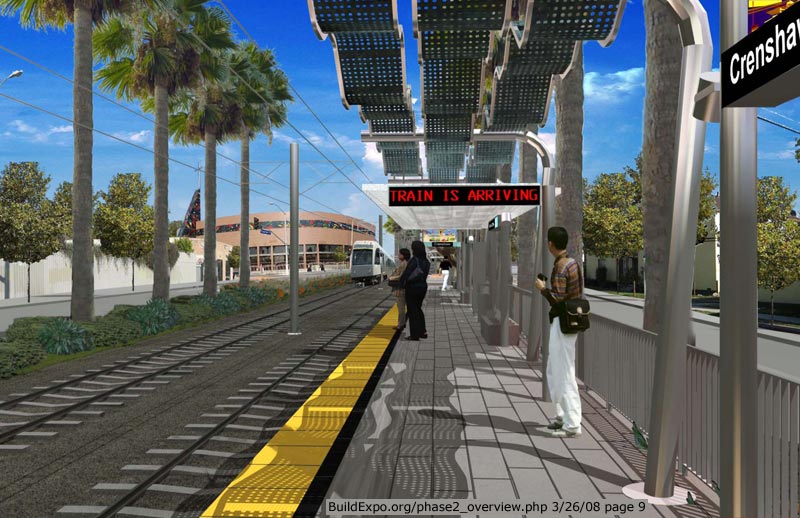 Typical at-grade station west of Crenshaw  La Brea aerial station 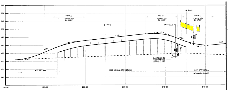 Here's a detail from 2000 that shows how the Expo bridge can fit over Sawtelle and under the 405 freeway (yellow), as long as Sawtelle is lowered 3 feet. The new Draft EIR Appendix E page T-005 shows about the same thing, but not as clearly. Most of Expo is pretty straight. Tight curves are possible, like on the Blue Line at Flower and Washington, but they slow the trains down. |
|


