|
|
Post by bluelineshawn on May 27, 2011 13:51:55 GMT -8
^I have to disagree. You can't judge future densification based on current buildup. Just because there are buildings on every lot, doesn't mean they can't be torn down and replaced with something more dense. The biggest impediment to densification on valuable land is zoning, and zoning changes are constrained by the wishes of the local population. I see opportunities for redevelopment at Vermont, Crenshaw, La Brea and La Cienega. Yes, all of those have existing uses, but those uses can and will be uprooted if there is money to be made. The quality of the redevelopment will primarily be limited by the city's ability to optimize the zoning near the station (as well as by the strength/weakness of the real estate market). Western, on the other hand, is not surrounded by valuable land, and won't be for the foreseeable future unless something drastic is done to the neighborhood. The only thing I know of going on at Western is Metro's planned removal of the used car lot on the northeast corner, to add parking and a "safety zone". I pretty much agree with this. The area that I expect to change the most and the fastest is the Figueroa (Flower too) corridor between downtown and USC. But pretty much every station will see something. Some sooner than others, but I really think that the view riding Expo in 2022 will be significantly different than the view in 2012. Here's a NY Times article from 2010 that's still relevant. |
|
Deleted
Deleted Member
Posts: 0
|
Post by Deleted on May 27, 2011 15:55:50 GMT -8
The difference being not what should the city do, but what will the city do. I'm all for upzoning and such, but with each passing year it becomes less politically viable to actually do it in existing SFR neighborhoods. Who knows, maybe I'll be wrong. We shall see.
|
|
|
|
Post by erict on May 27, 2011 18:58:48 GMT -8
From what I have seen around the Red line stations, the city has already changed the zoning laws and everything is in place for higher density development with less parking requirements. It did take a lot of time to establish. Maybe the same will be true of the Expo line.
But the real estate market is in the second great depression - everything is at a standstill until this passes.
|
|
|
|
Post by bzcat on May 27, 2011 19:14:19 GMT -8
The big variable in Expo redevelopment is how soon will USC students embrace living "west of Vermont". I put that in quotes because it is a mental barrier that historically has been the line drawn in the sand about where student housing ends and where the "community" starts. If Expo is successful in wooing USC students to live in Baldwin Hills or Culver City than I think there will be a lot of push from developers to rezone all the areas next to line between LaBrea and Vermont.
And once these students graduates from USC, maybe they will stick around in these station adjacent neighbors because of the easy commute to Santa Monica and Downtown LA where the jobs are.
I have no doubt that 15 years from now, there will be lots of high density mid rise condos all along the Expo line.
|
|
|
|
Post by thanks4goingmetro on May 28, 2011 2:43:12 GMT -8
Though there should be some upgrades put in place to make the place more walkable like, like curb cuts south of Jefferson on La Cienega for I have to in many cases dismount my bike to cross streets. Are you riding your bike on the sidewalk in this area? You must be looking forward to the bike path/lanes along the Expo Line! The new Los Angeles city bike plan suggests bike lanes on La Cienega, someday... I ride my bike on LaCienega between Santa Monica Blvd (West Hollywood) and Rodeo Rd. Bike lanes would be super! Riding on the sidewalk is a bad idea, a lot of pedestrians and bus shelters and broke up walkway. I already ride the bike lane on Exposition Blvd, going east is very nice. |
|
|
|
Post by metrocenter on Jun 4, 2011 9:32:56 GMT -8
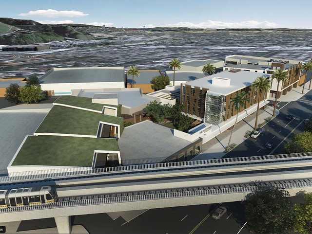
I'll mention the following projects, since I haven't seen them yet on this forum (I could be wrong). They are all in Culver City next to Culver City station: - The Platform - 40,000 sq ft retail/restaurant/entertainment complex by the Runyon Group. Located at the location of the old Mazda dealership (8840 Washington), south side of Washington between the ROW and Landmark Street. Developer plans to submit plans by the end of the year. Expected completion: 2013. (More info in this brochure.)
- Legado Crossing, a four-story mixed-use development by Legado Companies, including 115 apartments and 32,000 sq ft of retail (including a grocery store and drug store) on two acres near the station. Located at east corner of Washington/National (8770 Washington), old site of Spartan Supply. Construction to begin later this year.
[url= An article in la.curbed.com provides a brief summary of these projects. The curbed article also mentions an additional TOD concept being pursued by the Culver City Redevelopment Agency, on a six-acre parcel near the station. Culver City is also planning a special tax district for the area, to fund station area improvements. (If only the City of Los Angeles could give the area a little attention.) Here are some images of The Platform:   And here are images of Legado Crossing:   |
|
|
|
Post by metrocenter on Jun 4, 2011 10:51:58 GMT -8
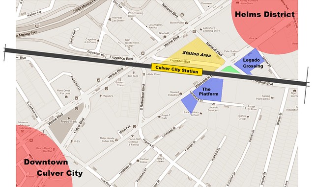
Here's a map of the two projects, in relation to their surroundings. Notice that these projects won't really extend the station area toward Downtown. If anything, they will fill in the dead area along Washington to the south and east, and in so doing will expand the Helms District (Father's Office, Dijonaise), extending it westward along Washington Blvd. to the station.  |
|
|
|
Post by bzcat on Jun 6, 2011 15:48:57 GMT -8
You are looking at future USC student housing right there...
|
|
|
|
Post by wad on Jun 7, 2011 4:27:43 GMT -8
That little Exposition Boulevard would make a great transit mall for buses.
|
|
|
|
Post by carter on Jun 7, 2011 12:18:46 GMT -8
That little Exposition Boulevard would make a great transit mall for buses. Are you referring to the stretch between Washington and Venice? If so, that's a good point. Could be a good option for the proposed new BBB 12, Culver City buses and the proposed shuttle to DTCC. |
|
|
|
Post by metrocenter on Jun 7, 2011 12:58:53 GMT -8
I need to update my map image (above). The station area does not extend all the way east to National Blvd, as shown in yellow on my image. The land between Exposition and National is actually owned by the Culver City Redevelopment Agency.
Really, the "station plaza" consists only of that land directly beneath the station structure. And the "station area" (controlled by Metro) only extends as far east as Exposition.
Expo is building a parking lot on most of the "station area". This lot will have two vehicle entrances: one on Robertson south of Venice, and one on Washington west of National.
There will also be another parking lot on the little south corner of Washington/National.
I want to believe that Exposition between Venice and Washington would be reserved for buses. That makes the most sense to me.
|
|
|
|
Post by wad on Jun 8, 2011 3:59:04 GMT -8
That little Exposition Boulevard would make a great transit mall for buses. Are you referring to the stretch between Washington and Venice? Yes, next to the station and shaded in yellow. The odd triangular street grid could actually help buses turn around quicker. |
|
|
|
Post by rajacobs on Sept 22, 2011 22:55:15 GMT -8
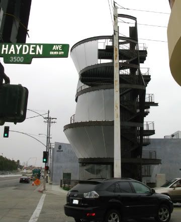
They were testing the Samitaur Tower  at Hayden tonight, 22 Sept.--sorry I don't have any pictures.  Wavy blue fields were projected on the plexiglass panels. I spoke with one of the system engineers who told me that the installation would be used only for projecting artwork. he said that under an agreement with Culver City, there would be no advertisement. Additionally, Samitaur reports on its website, www.samitaur.com/railLine.html, that there will be an additional 6 towers along the Expo Line.  "These Towers (marked by stars) will be constructed between the train stations, bringing the arts, sciences and humanities to a built-in audience of 27,000 passengers who will ride the train each day." "Each of the additional Towers will feature a unique iteration of the first Samitaur Tower design, incorporating the elements of projection screens, entertainment and exhibit space, and the Towers website. They will be connected, however, by the content on the various Tower screens, through chronological, serial, thematic and other carefully defined relationships." |
|
|
|
Post by bzcat on Nov 1, 2011 10:13:02 GMT -8
So they are going to build an elevated walkway to the pier? I doubt it...
|
|
|
|
Post by Gokhan on Nov 1, 2011 11:49:13 GMT -8
So they are going to build an elevated walkway to the pier? I doubt it... No... Santa Monica would never let anything elevated built there. High Line is an abandoned elevated freight line in New York, which was converted into a park. |
|
|
|
Post by carter on Nov 1, 2011 14:52:07 GMT -8
So they are going to build an elevated walkway to the pier? I doubt it... No... Santa Monica would never let anything elevated built there. High Line is an abandoned elevated freight line in New York, which was converted into a park. I think bzcat's point was that Expolinefan's analogy was, well, completely wrong. A better one is that 4th Street is going to look a lot like 4th Street Promenade, with maybe some limited vehicle access. |
|
|
|
Post by metrocenter on Nov 1, 2011 15:55:42 GMT -8
No... Santa Monica would never let anything elevated built there. High Line is an abandoned elevated freight line in New York, which was converted into a park. I think bzcat's point was that Expolinefan's analogy was, well, completely wrong. A better one is that 4th Street is going to look a lot like 4th Street Promenade, with maybe some limited vehicle access. The link from expolinefan was confusing, since he made no connection in his post between the topic (Santa Monica) and the links (NYC's High Line Park). And I think you meant to say: A better [analogy] is that Colorado Avenue is going to look a lot like 3rd Street Promenade, with maybe some limited vehicle access. |
|
|
|
Post by carter on Nov 1, 2011 16:30:28 GMT -8
Gotcha! Glad we're all on the same page  |
|
|
|
Post by joshuanickel on Nov 1, 2011 20:49:05 GMT -8
What I ment to Show is what the Design Group did in NYC that was Picked by Santa Monica for there pedestrian mall from 4th to the Pier I Never stated it would be Elevated this was just to show an example of the Design teams work James Corner designed the high line. He is the one designing the park across from city hall in Santa monica: www.smciviccenterparks.com/The city has hired Peter Walker to design the pedestrian esplanade not James Corner. Peter Walker is the one who designed the 9/11 memorial at the World Trade Center Site. Here is a link to the website that describes the project: www.smgov.net/bebp/project.aspx?id=26286 |
|
|
|
Post by metrocenter on Nov 9, 2011 10:13:22 GMT -8
|
|
|
|
Post by rajacobs on Nov 9, 2011 11:42:32 GMT -8
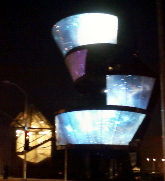
The Media Tower between La Cienega and Culver Station was under full test last night. The photo is blurry, but captures its capability. An engineer confirmed that no ads are planned for the installation, only artwork.  |
|
|
|
Post by davebowman on Jan 5, 2012 16:27:11 GMT -8
|
|
|
|
Post by rubbertoe on Feb 7, 2012 10:31:50 GMT -8
|
|
|
|
Post by carter on Feb 7, 2012 13:40:16 GMT -8
Those 1500 proposed parking spaces are a huge red flag though. |
|
|
|
Post by James Fujita on Feb 7, 2012 16:01:33 GMT -8
I don't think the parking spaces are necessarily a red flag.
You have to consider that the parking spaces will be underground and there will undoubtedly be park-and-ride Expo Line commuters from surrounding areas beyond the walkable reach of the light rail station. Los Angeles is still much bigger than its bus and rail network, and not all communities are equally transit-friendly.
|
|
|
|
Post by Gokhan on Feb 7, 2012 16:49:14 GMT -8
Any opinions about this being built by a private developer rather than a redevelopment agency, which was dissolved thanks to new state legislature?
I thought a redevelopment agency could do a better work. I am a little skeptical about a private firm building something nice here. I hope I am wrong.
|
|
|
|
Post by LAofAnaheim on Feb 7, 2012 17:25:56 GMT -8
I don't think the parking spaces are necessarily a red flag. You have to consider that the parking spaces will be underground and there will undoubtedly be park-and-ride Expo Line commuters from surrounding areas beyond the walkable reach of the light rail station. Los Angeles is still much bigger than its bus and rail network, and not all communities are equally transit-friendly. James, what people fail to consider is the COST of building parking spaces. For a single underground spot, the average is around $50,000. $50,000 x 1,500 spaces = $75,000,000. Just think about that. That's a HUGE prohibitive when building true dense development. This is the reason lot of people drive in LA.......our parking is too convenient. It took 14 years to build the Walt Disney Concert Hall.......why? b/c it took 10 years and a near bankruptcy to build the underground parking structure. For a Metro station.....1,500 is ludicrous and hurts the pedestrian vibe of an area. Imagine if its 10 pm, people will be like "why take Metro, there's hundreds of parking spots below". That's our problem. |
|
|
|
Post by James Fujita on Feb 7, 2012 18:56:33 GMT -8
Culver City isn't downtown Los Angeles. The situation is totally different.
I suspect that this station will be more like some of the other park-and-ride stations on the Blue Line and elsewhere on the Metro Rail network. Yes, people will drive to the station and use the parking at the TOD. The cost is the price to pay for extending the reach of the station.
Congratulations to those who can live near the Washington/ National crossing, but there are plenty of people who may support rail transit but who live further away from the station. I see nothing wrong with driving a couple of miles and using the Expo Line for the rest of the trip to USC, the convention center or downtown Los Angeles.
It's not a question of "why take the train when there is cheap parking" it is a question of "why drive all the way downtown when I can leave my car behind in Culver City"
=
EDIT: Gokhan, I suppose it depends on if you prefer L.A. Live (AEG + CRA), Hollywood and Highland (Trizec + CRA) or the Grove (Caruso)
|
|
|
|
Post by Gokhan on Feb 7, 2012 20:28:31 GMT -8
EDIT: Gokhan, I suppose it depends on if you prefer L.A. Live (AEG + CRA), Hollywood and Highland (Trizec + CRA) or the Grove (Caruso) They are all very impressive entertainment complexes. Perhaps LA Live and Hollywood & Highland are more sophisticated and substantial than the Grove. Now, my new question is, is there any chance that we will see anything somewhat of a similar caliber at the Culver Junction -- which is also the name I prefer for this venue -- or will it be some mediocre commercial and residential establishment -- more like the Target Casden Properties will build at Exposition and Sepulveda in place of the cement plant. PS: The cement-plant land cost about three times as much as the Culver Junction land -- $75 million vs. $25 million. |
|
|
|
Post by James Fujita on Feb 8, 2012 16:22:23 GMT -8
Well, we are in the middle of an economic recovery. Lowe Enterprises has to keep that in mind. Also, Lowe and Culver City can reach out to any number of retailers, restaurant chains or entertainment businesses, but <insert name of favorite store here> can still say no.
It does sound like Lowe will keep in mind what Culver City wants. Ultimately, the community needs to get what the community wants, even if that's not the Grove or L.A. Live.
To quote: "a mix of housing, office, retail and restaurant use surrounding a large central open space amenity and connect seamlessly with the new station and the emerging Washington National Transit Oriented Development District"
Sounds pretty good to me.
|
|