|
|
Post by Gokhan on Dec 31, 2013 7:21:45 GMT -8
It looks like if they could build the bike path immediately adjacent to the northern track fence at the track level, they could avoid both retaining walls and removal of mature trees and landscaping.
The original plans were to build the bike path on the northern slope of the trench on a step higher from the tracks, which would require expensive retaining walls and removal of all existing trees and landscaping. An alternative plan is to take the southern section of Northvale Road to build a Class 1 bike path there but that will also require the removal of the existing landscaping.
|
|
|
|
Post by joemagruder on Dec 31, 2013 10:31:37 GMT -8
My gut doesn't like the removal of trees, but I have been reminded that one of the costs of planting lots of trees in urban areas - a good in my book - is that some will have to be removed in the future when the land is repurposed.
|
|
|
|
Post by jamesinclair on Jan 2, 2014 23:37:41 GMT -8
It looks like if they could build the bike path immediately adjacent to the northern track fence at the track level, they could avoid both retaining walls and removal of mature trees and landscaping. The original plans were to build the bike path on the northern slope of the trench on a step higher from the tracks, which would require expensive retaining walls and removal of all existing trees and landscaping. An alternative plan is to take the southern section of Northvale Road to build a Class 1 bike path there but that will also require the removal of the existing landscaping.No, its not required. One could remove a lane, instead. Which seams like the prudent thing to do for a TRANSIT project. |
|
|
|
Post by Gokhan on Jan 3, 2014 3:54:56 GMT -8
It looks like if they could build the bike path immediately adjacent to the northern track fence at the track level, they could avoid both retaining walls and removal of mature trees and landscaping. The original plans were to build the bike path on the northern slope of the trench on a step higher from the tracks, which would require expensive retaining walls and removal of all existing trees and landscaping. An alternative plan is to take the southern section of Northvale Road to build a Class 1 bike path there but that will also require the removal of the existing landscaping.No, its not required. One could remove a lane, instead. Which seams like the prudent thing to do for a TRANSIT project. Except, Northvale Road right-of-way is only 46-to-50-ft-wide. There is not much space there for a 12-ft-wide bike path, one 12-ft-wide car lane in either direction, a sidewalk, and parking lane on the north side of the road. In fact, you can measure on Google Earth that there is 30 ft or less of space between the parked cars on the north and the fence on the south. Subtract a minimum of 12 ft for the bike path from that, you only have 18 ft left for the cars -- awfully narrow. So, as I said before, it's not an easy fit at all and no option is easy here. |
|
|
|
Post by rajacobs on Jan 3, 2014 10:52:55 GMT -8
There is not much space there for a 12-ft-wide bike path, one 12-ft-wide car lane in either direction, a sidewalk, and parking lane on the north side of the road. True, but if you subtract the parking lane on the north side, it's no problem. That is, eliminate parking on the north side of the road. I've never understand why in Los Angeles, on streets that barely support bi-directional traffic, parking on both sides of the road are allowed. That wasn't the case on the street I grew up on or surrounding residential streets. Northvale would seem to qualify as such a low-use street ...unless construction of the path + proximity to a station changes the equation. |
|
|
|
Post by Gokhan on Jan 3, 2014 13:24:42 GMT -8
There is not much space there for a 12-ft-wide bike path, one 12-ft-wide car lane in either direction, a sidewalk, and parking lane on the north side of the road. True, but if you subtract the parking lane on the north side, it's no problem. That is, eliminate parking on the north side of the road. I've never understand why in Los Angeles, on streets that barely support bi-directional traffic, parking on both sides of the road are allowed. That wasn't the case on the street I grew up on or surrounding residential streets. Northvale would seem to qualify as such a low-use street ...unless construction of the path + proximity to a station changes the equation. You mean eliminate parking on both sides of Northvale Road, even on the north side (houses side)? The alternative would already eliminate parking on the south side. With that, there is 18 ft or less of space for the car lanes without landscaping removal, which is really narrow. If they eliminated parking on both sides, there would be more space, but that would decrease the quality of life of the neighborhood. I'm sure most people would like to have some street parking on their street for their guests, deliveries, extra cars, etc. |
|
|
|
Post by rajacobs on Jan 3, 2014 14:50:44 GMT -8
Got it... I read the post to refer to the north side of the tracks, not the road. Parking on the housing side is essential.
|
|
|
|
Post by fissure on Jan 4, 2014 12:33:28 GMT -8
Except, Northvale Road right-of-way is only 46-to-50-ft-wide. There is not much space there for a 12-ft-wide bike path, one 12-ft-wide car lane in either direction, a sidewalk, and parking lane on the north side of the road. In fact, you can measure on Google Earth that there is 30 ft or less of space between the parked cars on the north and the fence on the south. Subtract a minimum of 12 ft for the bike path from that, you only have 18 ft left for the cars -- awfully narrow. So, as I said before, it's not an easy fit at all and no option is easy here. Is it really necessary to have freeway-width lanes on a neighborhood street? Heaven forbid people have to slow down in the rare event that two cars pass each other. Or if they're SUVs instead of sedans one can always duck into a curb cut while the other passes. With Manning a block away, you could even turn it into a one-way street and allow parking on both sides without disturbing the flow of traffic much. There's plenty of space if you're willing to sometimes add an extra ten seconds to someone's trip. |
|
|
|
Post by Gokhan on Jan 4, 2014 18:16:44 GMT -8
Except, Northvale Road right-of-way is only 46-to-50-ft-wide. There is not much space there for a 12-ft-wide bike path, one 12-ft-wide car lane in either direction, a sidewalk, and parking lane on the north side of the road. In fact, you can measure on Google Earth that there is 30 ft or less of space between the parked cars on the north and the fence on the south. Subtract a minimum of 12 ft for the bike path from that, you only have 18 ft left for the cars -- awfully narrow. So, as I said before, it's not an easy fit at all and no option is easy here. Is it really necessary to have freeway-width lanes on a neighborhood street? Heaven forbid people have to slow down in the rare event that two cars pass each other. Or if they're SUVs instead of sedans one can always duck into a curb cut while the other passes. With Manning a block away, you could even turn it into a one-way street and allow parking on both sides without disturbing the flow of traffic much. There's plenty of space if you're willing to sometimes add an extra ten seconds to someone's trip. Freeway-width lane is 12-ft-wide. About 10-ft-wide is OK for some streets. Here, it would be only about 8-ft-wide, somewhat dangerously narrow. Again, it's not an easy fit at all. |
|
|
|
Post by jamesinclair on Jan 9, 2014 1:01:18 GMT -8
No, its not required. One could remove a lane, instead. Which seams like the prudent thing to do for a TRANSIT project. Except, Northvale Road right-of-way is only 46-to-50-ft-wide. There is not much space there for a 12-ft-wide bike path, one 12-ft-wide car lane in either direction, a sidewalk, and parking lane on the north side of the road. In fact, you can measure on Google Earth that there is 30 ft or less of space between the parked cars on the north and the fence on the south. Subtract a minimum of 12 ft for the bike path from that, you only have 18 ft left for the cars -- awfully narrow. So, as I said before, it's not an easy fit at all and no option is easy here. 12ft bike 10 ft car 10 ft car 8 foot parking 6 foot sidewalk = 46 7 foot parking is also acceptable. Feel free to allocate the extra space as needed. |
|
|
|
Post by Gokhan on Jan 9, 2014 8:08:29 GMT -8
Except, Northvale Road right-of-way is only 46-to-50-ft-wide. There is not much space there for a 12-ft-wide bike path, one 12-ft-wide car lane in either direction, a sidewalk, and parking lane on the north side of the road. In fact, you can measure on Google Earth that there is 30 ft or less of space between the parked cars on the north and the fence on the south. Subtract a minimum of 12 ft for the bike path from that, you only have 18 ft left for the cars -- awfully narrow. So, as I said before, it's not an easy fit at all and no option is easy here. 12ft bike 10 ft car 10 ft car 8 foot parking 6 foot sidewalk = 46 7 foot parking is also acceptable. Feel free to allocate the extra space as needed. So, you're advocating to reduce the existing sidewalk width? Not to mention the inconvenience it would create for the pedestrians and cutting many dozens of trees, it would cost perhaps 20 million dollars or more to reconstruct the sidewalk for such a long section, comparable to the whole budget for the bike path. |
|
|
|
Post by Gokhan on Jan 30, 2014 10:23:42 GMT -8
Expo Line Phase 2 bike and pedestrian path, looking west from Venice Blvd: 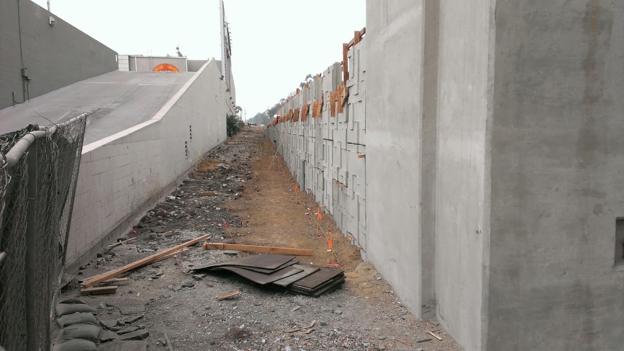 An embankment, instead of a wall, is being built on the other side of the bridge. Expensive, useful, valuable, scarce land is wasted thanks to rather mindless cost cutting. This area also could have been a walkway and bike path or even a small commercial strip. They wasted millions of dollars in order to save a hundred thousand. This is because of the poor supervision of Expo Authority by Metro and poor supervision of the design - build contractor by Expo Authority:  |
|
|
|
Post by Gokhan on Apr 24, 2014 10:21:55 GMT -8
Everything you want to know about Expo bicycle and pedestrian path: March 2014 Bicycle Advisory Committee presentation (PDF file)Phase 1 - Phase 2 interface is nonexistence -- two separate bike paths with no easy way to get to one from the other -- and Expo Authority isn't assuming responsibility for it. Pico/Gateway/Sawtelle crossing is horrendous. They should have really put the bike and pedestrian path on the bridges wherever it was needed. Continuing the platform on the Venice Blvd bridge to the north of Venice Blvd was also a no-brainer but they didn't do it. |
|
|
|
Post by RMoses on Apr 24, 2014 11:25:44 GMT -8
Everything you want to know about Expo bicycle and pedestrian path: March 2014 Bicycle Advisory Committee presentation (PDF file)Phase 1 - Phase 2 interface is nonexistence -- two separate bike paths with no easy way to get to one from the other -- and Expo Authority isn't assuming responsibility for it. Pico/Gateway/Sawtelle crossing is horrendous. They should have really put the bike and pedestrian path on the bridges wherever it was needed. Continuing the platform on the Venice Blvd bridge to the north of Venice Blvd was also a no-brainer but they didn't do it. Crosswalks, mid block on Olympic, under the bridge - accidents just waiting to happen. |
|
|
|
Post by bzcat on Apr 24, 2014 15:40:48 GMT -8
Crosswalks, mid block on Olympic, under the bridge - accidents just waiting to happen. I see that and raise you the 3 stages single side crossing at Pico/Gateway  or the East bound Venice Blvd crossing in front of the freeway offramp...  |
|
|
|
Post by rajacobs on Apr 25, 2014 0:22:20 GMT -8
I think all of us saw this coming a long time ago...
|
|
|
|
Post by Gokhan on Jun 27, 2014 11:23:34 GMT -8
Interesting Expo Bike Path development:
No pictures, but I saw that they were painting the bike crossing at Exposition/Rodeo/Gramercy green. A very good idea!
|
|
|
|
Post by Gokhan on Jul 9, 2014 12:10:09 GMT -8
Here it is:  |
|
|
|
Post by Alexis Kasperavičius on Oct 27, 2014 6:45:05 GMT -8
Here's a nice video tour of the Culver City end of the bike path now that some time has passed since opening:
|
|
|
|
Post by Gokhan on Feb 10, 2015 13:30:17 GMT -8
It looks like the Expo Line Phase 2 bike & pedestrian multiuse path will be concrete. There is a tiny landscaping strip in this section at Bagley Avenue.  |
|
|
|
Post by Philip on Feb 10, 2015 14:07:25 GMT -8
It looks like the Expo Line Phase 2 bike & pedestrian multiuse path will be concrete. Was there ever a question that it wouldn't have been? |
|
|
|
Post by Gokhan on Feb 10, 2015 15:38:27 GMT -8
It looks like the Expo Line Phase 2 bike & pedestrian multiuse path will be concrete. Was there ever a question that it wouldn't have been? Expo Line Phase 1 bike path is asphalt. |
|
|
|
Post by Philip on Feb 10, 2015 17:15:02 GMT -8
Ah, gotcha. Thank you for clearing that up!  |
|
|
|
Post by Gokhan on May 12, 2015 15:08:12 GMT -8
First Expo Line Phase 2 bike lanes, looking east from Clarington Ave. Note that there will be a gap between Clarington Avene and Putney Road.  |
|
|
|
Post by johanragle on May 12, 2015 16:25:28 GMT -8
Expo Line Phase 1 bike path is asphalt. The only Phase 1 section that's asphalt is the short bit behind the MSE wall between La Cienega/Jefferson and National Blvd (and even that's confusing since there are sharrows marked along Jefferson as well for that segment). From National to Culver City it's all concrete, and from USC to La Cienega it's just bike lanes in the street. |
|
f ron
Full Member

Posts: 222
|
Post by f ron on May 12, 2015 17:03:54 GMT -8
Expo Line Phase 1 bike path is asphalt. The only Phase 1 section that's asphalt is the short bit behind the MSE wall between La Cienega/Jefferson and National Blvd (and even that's confusing since there are sharrows marked along Jefferson as well for that segment). From National to Culver City it's all concrete, and from USC to La Cienega it's just bike lanes in the street. Looks like the segments between Overland and Sepulveda will be a combination of concrete and asphalt. After that concrete to the Santa Monica city borders where it reverts to asphalt again. God help us cyclists when it comes to the Pico crossing. It's shaping up to be pretty dismal compared to the effort put into everything else. |
|
|
|
Post by joshuanickel on May 12, 2015 18:47:31 GMT -8
Expo Line Phase 1 bike path is asphalt. The only Phase 1 section that's asphalt is the short bit behind the MSE wall between La Cienega/Jefferson and National Blvd (and even that's confusing since there are sharrows marked along Jefferson as well for that segment). From National to Culver City it's all concrete, and from USC to La Cienega it's just bike lanes in the street. The segment from National to Culver City is asphalt except for the balona creek bridge and the very end where it merges with the sidewalk. Here is a pic of that segment: 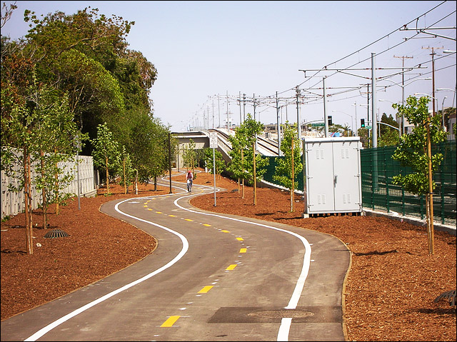 |
|
|
|
Post by johanragle on May 12, 2015 19:32:29 GMT -8
Derp. I've ridden that path plenty of times but for some reason I thought it was concrete all the way.
Might have stuck in my mind that way because the hidden path behind MSE wall is unpainted while the rest is painted...
|
|
|
|
Post by Gokhan on May 19, 2015 12:48:35 GMT -8
I haven't been able to find any news on the final routing through the Northvale area. Is it still up in the air? la.streetsblog.org/2015/05/18/expo-phase-ii-bike-path-will-open-with-light-rail-in-2016/Expo: Phase II Bike Path Will Open with Light Rail in 2016 by Damien Newton The Expo Bike Path near Military Avenue in Westwood. All images via the Expo Construction Authority. Last week, in a short article celebrating that LADOT was beginning its portion of the bikeway that will run parallel to the Expo Line in West L.A., I stated that the separated bike path portion of the route was not under construction. I couldn’t have been more wrong. Via the Expo Construction Authority comes word that not only is the bike path under construction, it should open with the light rail line in early 2016. The bike path is well under construction, and the plan is to open the bike path along with the light rail line. Currently there is grading, lighting, irrigation, and drainage work throughout, and approximately one mile has already been paved. The largest stretch of paving is between Centinela and the 26th Street/Bergamot station, and the sections from Olympic to 20th Street and from Westwood to Military have also been paved. There are still some issues to be worked out, most notably the routing of the bike path in the area surrounding Westwood Station where there are also plans for a greenway and water park. However, the good news is that both Metro’s separated bike path and the bike lanes being painted by LADOT to provide easy access from downtown Culver City to downtown Santa Monica are currently under construction/paint and the full route should be ready for a ribbon cutting with the train. My apologies to both the Construction Authority and our readers for getting it wrong. There are two more pictures of Expo Bike Path as it is today, after the jump. The section between Clarington Avenue and Putney Road is not part of the current bike and pedestrian multiuse path. It's not being built by Expo Authority and/or Skanska/Rados. It will be built by the City of Los Angeles a few years later. It's at the design stage. Yes, the rest of the bike path has been making good progress. |
|
|
|
Post by Gokhan on May 30, 2015 10:34:24 GMT -8
|
|